20200202-003b: Springdale Green PUD, C814-2020-0104 backup packet 1 of 2 — original pdf
Backup
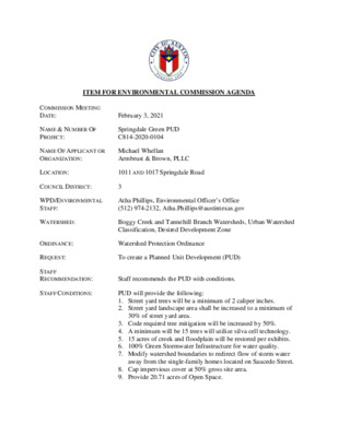
ITEM FOR ENVIRONMENTAL COMMISSION AGENDA COMMISSION MEETING DATE: February 3, 2021 NAME & NUMBER OF PROJECT: Springdale Green PUD C814-2020-0104 NAME OF APPLICANT OR ORGANIZATION: Michael Whellan Armbrust & Brown, PLLC LOCATION: 1011 AND 1017 Springdale Road COUNCIL DISTRICT: 3 WPD/ENVIRONMENTAL STAFF: Atha Phillips, Environmental Officer’s Office (512) 974-2132, Atha.Phillips@austintexas.gov WATERSHED: Boggy Creek and Tannehill Branch Watersheds, Urban Watershed Classification, Desired Development Zone ORDINANCE: Watershed Protection Ordinance REQUEST: To create a Planned Unit Development (PUD) STAFF RECOMMENDATION: Staff recommends the PUD with conditions. STAFF CONDITIONS: PUD will provide the following: 1. Street yard trees will be a minimum of 2 caliper inches. 2. Street yard landscape area shall be increased to a minimum of 30% of street yard area. 3. Code required tree mitigation will be increased by 50%. 4. A minimum will be 15 trees will utilize silva cell technology. 5. 15 acres of creek and floodplain will be restored per exhibits. 6. 100% Green Stormwater Infrastructure for water quality. 7. Modify watershed boundaries to redirect flow of storm water away from the single-family homes located on Saucedo Street. 8. Cap impervious cover at 50% gross site area. 9. Provide 20.71 acres of Open Space. 10. Remove existing impervious cover from the critical water quality zone and restore with native vegetation. 11. Capture rainwater and condensate to reduce landscape water usage by 50%. 12. Meet 3-Star green building rating for all buildings on-site. Page 2 of 2 Springdale Green PUD C814-2020-0104 Atha Phillips Environmental Officer’s Office Site Location Austin ETJ Austin City Limits Edwards Aquifer Recharge Zone Edwards Aquifer Contributing Zone North Site Location North Background: • 30.18 acres • Boggy Creek and Tannehill Branch Watersheds • Urban Watershed Classification • Desire Development Zone • Brown Field site • Proposed Use: Office • Council District: 3 1987 Aerial – Tank Farm Site Location North Boggy Creek Watershed Tannehill Branch Watershed Boundary Site Location North Boggy Creek Watershed Tannehill Branch Critical Water Quality Zone Site Location North View from Springdale View from Airport Blvd. Required Open Space: 6.04 acres Provided: 19.82 acres Open Space Plan Restoration Plan Comparison: Existing Code Proposed PUD 100% capture volume or payment in lieu 100% Green Stormwater Infrastructure Water Quality Drainage No adverse impact No adverse impact. Site will modify watershed boundaries to pull flow of storm water away the single-family homes located on Saucedo Street Impervious Cover 90% Commercial Less than 50% Open Space 20% of non-residential tracts (Tier 1) Additional 20% (Tier 2) 6.04 acres 20.71 acres Floodplain & CWQZ Restoration Restored as required in the ECM. Open space areas and critical water quality zones shall be restored with appropriate native vegetation outlined in the PUD. Restoration goes beyond what is required by code. CWQZ Commercial impervious cover is not allowed within the buffer. PUD will remove existing impervious cover and restore the creek buffer with native vegetation. Comparison: Critical Water Quality Zone Critical Water Quality Zone Existing Code Proposed PUD Trails within the buffer are limited to 12’ Staging within the CWQZ buffer Landscape Irrigation Potable water Landscape Trees Current code Current code including Heritage Tree ordinance Trails within the CWQZ will be wider in some places and should match the Open Space exhibit. Temporary staging will be allowed within the CWQZ during construction in the areas designated on the plan. After construction, the site will be de-compacted and restored per the restoration plan. Capture rainwater and condensate to reduce water usage by 50% -Will provide silva cells for a minimum of 15 trees Will provide 50% greater mitigation than -Street yard trees increased by ½” caliper code requires -Will provide trees and vegetation for 30% of street yard Dark Sky Initiative Green Building Full cut-off or shielded per Subchapter E Full cut-off or shielded per Subchapter E 2-Star Certified 3-Star Certified Environmental Code Modifications 25-8-261 Critical Water Quality Zone Development 1. 25-8-261(B)(3)(C) is modified to allow a trail wider than 12 feet as shown on the Creek Plan. 2. 25-8-261 is modified to allow temporary construction staging within the CWQZ buffer per the Construction Laydown and Staging Limits exhibit. Recommendation Recommended with the following conditions: 1. Street yard trees will be a minimum of 2 caliper inches. 2. Street yard landscape area shall be increased to a minimum of 30% of street yard area. 3. Code required tree mitigation will be increased by 50%. 4. A minimum will be 15 trees will utilize silva cell technology. 5. 15 acres of creek and floodplain will be restored per exhibits. 6. 100% Green Stormwater Infrastructure for water quality. 7. Modify watershed boundaries to redirect flow of storm water away from the single-family homes located on Saucedo Street. 8. Cap impervious cover at 50% gross site area. 9. Provide 20.71 acres of Open Space. 10. Remove existing impervious cover from the critical water quality zone and restore with native vegetation. 11. Capture rainwater and condensate to reduce landscape water usage by 50%. 12. Meet 3-Star green building rating for all buildings on-site. Questions? Atha Phillips Environmental Officer’s Office (512) 974-2132 Atha.Phillips@austintexas.gov