20201202-002b: 1514 W Koenig Lane Office Building, SP-2019-0027CT variance packet — original pdf
Backup
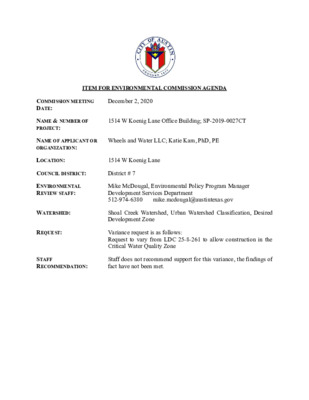
ITEM FOR ENVIRONMENTAL COMMISSION AGENDA December 2, 2020 1514 W Koenig Lane Office Building; SP-2019-0027CT Wheels and Water LLC; Katie Kam, PhD, PE COMMISSION MEETING DATE: NAME & NUMBER OF PROJECT: NAME OF APPLICANT OR ORGANIZATION: LOCATION: 1514 W Koenig Lane COUNCIL DISTRICT: District # 7 ENVIRONMENTAL REVIEW STAFF: Mike McDougal, Environmental Policy Program Manager Development Services Department 512-974-6380 mike.mcdougal@austintexas.gov WATERSHED: REQUEST: Shoal Creek Watershed, Urban Watershed Classification, Desired Development Zone Variance request is as follows: Request to vary from LDC 25-8-261 to allow construction in the Critical Water Quality Zone STAFF RECOMMENDATION: Staff does not recommend support for this variance, the findings of fact have not been met. Development Services Department Staff Recommendations Concerning Required Findings Project Name: Ordinance Standard: Watershed Protection Ordinance Variance Request: 1514 W Koenig Ln Office Building SP-2019-0027CT Request to vary from LDC 25-8-261 to allow construction in the Critical Water Quality Zone Include an explanation with each applicable finding of fact. A. Land Use Commission variance determinations from Chapter 25-8-41 of the City Code: 1. The requirement will deprive the applicant of a privilege available to owners of similarly situated property with approximately contemporaneous development subject to similar code requirements. Yes. The applicant proposes to demolish the original single family structure built in 1952 and construct an office building. The proposed project is located on Koenig Lane between Burnet Road and North Lamar Boulevard (see Staff Exhibit 1 – Vicinity Map). Most properties fronting this segment of Koenig Lane consist of single family residences that have been expanded for or replaced with commercial use. The existing impervious cover is 35.5% (approximately 2600 square feet); the proposed impervious cover is 70% (approximately 5000 square feet). Adjacent properties on Koenig Lane have existing impervious cover ranging from 19% to 91%. The proposed project is generally consistent with other development located along Koenig Lane. 2. The variance: a) Is not necessitated by the scale, layout, construction method, or other design decision made by the applicant, unless the design decision provides greater overall environmental protection than is achievable without the variance; No. The entire property is located within the Critical Water Quality Zone. The proposed project represents a design decision that does not provide greater overall environmental protection than is achievable without the variance. Is the minimum deviation from the code requirement necessary to allow a reasonable use of the property; Yes. The Critical Water Quality Zone associated with the adjacent creek (the Hancock Branch of Shoal Creek) is approximately 400 feet wide. The entire lot is located within the Critical Water Quality Zone. There is not opportunity to adjust construction to be located outside of the Critical Water Quality Zone (see Staff Exhibit 2 – Property Location and Characteristics). Increasing the impervious cover is necessary to allow for the property to be converted to a commercial use with on-site parking. The applicant has minimized the proposed impervious cover by reducing the on-site parking from 15 to 10 spaces. This has been achieved by providing offsite parking and through parking alternatives, including an urban core reduction and by providing on-site shower facilities to promote alternative commuting options. Does not create a significant probability of harmful environmental consequences. No. The project as currently proposed increases pollutant load due to the additional impervious cover. Development with the variance will result in water quality that is at least equal to the water quality achievable without the variance. No. The additional impervious cover will increase pollutant load over existing conditions. b) c) B. The Land Use Commission may grant a variance from a requirement of Section 25-8- 422 (Water Supply Suburban Water Quality Transition Zone), Section 25-8-452 (Water Supply Rural Water Quality Transition Zone), Section 25-8-482 (Barton Springs Zone Water Quality Transition Zone), Section 25-8-368 (Restrictions on Development Impacting Lake Austin, Lady Bird Lake, and Lake Walter E. Long), or Article 7, Division 1 ( Critical Water Quality Zone Restrictions ), after determining that:: The criteria for granting a variance in Subsection (A) are met; No. The criteria for granting a variance in Subsection A have not been met. The requirement for which a variance is requested prevents a reasonable, economic use of the entire property; Yes. The entire property is located within the Critical Water Quality Zone. There is no opportunity to shift construction to avoid the Critical Water Quality Zone on this lot. Koenig Lane is a TxDOT roadway, but equates generally to a City of Austin minor arterial roadway. As such, single family residential represents an unsuitable use and most single family properties along Koenig Lane have been converted to commercial / office use. Any commercial use for this property requires construction in the Critical Water Quality Zone with a development footprint larger than the original single family development. The entire property cannot be reasonably used without construction in the Critical Water Quality Zone. 3. 1. 2. 3. The variance is the minimum deviation from the code requirement necessary to allow a reasonable, economic use of the entire property. Yes. The entire lot is located within the Critical Water Quality Zone. There is not opportunity to adjust construction to be located outside of the Critical Water Quality Zone. The applicant has minimized the proposed impervious cover by reducing the on-site parking from 15 to 10 spaces. This has been achieved by providing offsite parking and through parking alternatives, including an urban core reduction and by providing on-site shower facilities to promote alternative commuting options. The development footprint must be expanded beyond the existing development in order to use the property for commercial purposes. Staff Determination: Staff determines that the findings of fact have not been met. However, Staff would recommend the following condition if the variance is approved: The applicant will provide on-site water quality treatment to reduce pollutant load for the proposed project below existing conditions in addition to providing a water quality fee-in-lieu payment. Environmental Review Manager (DSD) ____________________________ Mike McDougal Date 11/17/2020 Environmental Officer (WPD) ____________________________ Chris Herrington Date ________ 11/17/2020 Staff Exhibit 1 – Vicinity Map North Staff Exhibit 2 – Property Location and Characteristics Waterway Centerline 1514 W Koenig Ln Critical Water Quality Zone North Wheels & Water LLC Austin, Texas 78723 Texas Registered Engineering Firm F-19740 http://www.wheelsandwaterllc.com July 13, 2020 Mike McDougal Environmental Policy Program Manager City of Austin Watershed Protection Department 505 Barton Springs Road Austin, Texas 78704 Re: Environmental variance requests for 1514 W. Koenig Lane Office Building, Austin, Texas 78756 Case: SP-2019-0027C To Mr. McDougal: Per staff’s determination, site plan case SP-2019-0027C must go to the Environmental Commission for a variance from Austin Land Development Code (LDC) section 25-8-261 because of the proposal to develop a three-story office building (the “proposed development”) at 1514 West Koenig Lane within the Critical Water Quality Zone (CWQZ) of the Hancock Branch of Shoal Creek. LDC section 25-8-261 states the following: In all watersheds, development is prohibited in a critical water quality zone except as provided in this Division. Development allowed in the critical water quality zone under this Division shall be revegetated and restored within the limits of construction as prescribed by the Environmental Criteria Manual. The purposes of this letter are to 1) explain why staff’s determination that this case needs a variance should be reconsidered, and 2) to request approval of the variance and describe findings of fact if there continues to be a determination that the variance is needed. Determination for Variance A request was made for staff to not apply the CWQZ to the property per LDC 25-8-92 (C) (2), which states: Notwithstanding the provisions of Subsection (C)(1), a critical water quality zone does not apply to a previously modified drainage feature serving a railroad or public roadway right-of-way that does not possess any natural and traditional character and cannot reasonably be restored to a natural condition. The last phrase “restored to a natural condition” indicates that the drainage feature referred to in LDC 25- 8-92 (C) (2) is intended to be a feature that at one point was a natural drainage feature with natural condition. The Hancock Branch of Shoal Creek was clearly modified in the construction of the subdivision to be a drainage feature to serve the Arroyo Seco roadway withing the public roadway right-of-way (Figure 1). The creek is hemmed in between the two Arroyo Seco roadways; therefore, not able to naturally meander (Figure 1 and Figure 2). Curb inlets from the street to the creek (Figure 2) indicate Hancock Branch was made to be the drainage feature for Arroyo Seco. Thus, this project should have been exempt Page 1 of 9 from the CWQZ regulations and not subject to requirement to go to the Environmental Commission for variance approval. The intention of establishing a CWQZ is to create an area free of development to preserve the natural and traditional character of the waterway and for the treatment of water through natural means (e.g., flowing and infiltrating within the CWQZ). As can be seen in Figure 1, the CWQZ for the Hancock Branch north of Koenig Lane consists mostly of the paved Arroyo Seco roadway; therefore, for many decades, the Hancock Branch has not had a preserved CWQZ. The zone has consisted of primarily roadway pavement, with the road and surrounding development pre-dating the City’s watershed protection ordinances. For the CWQZ within the orange circle shown within Figure 1, Table 1 shows that about 50% of the CWQZ near the subject property is currently paved with impervious cover and 27% of the CWQZ at that intersection consists of roadway. Water quality controls do not exist for the roadways and the development. Figure 2 shows photos of the creek consisting mostly of vegetation that is periodically mowed down for maintenance. There are no plans to remove Koenig Lane, Palo Duro Canyon, and Arroyo Seco roadways and the existing commercial and residential impervious cover to restore the CWQZ to a natural condition. An open records request to identify what projects have received the LDC 25-8-92 (C) (2) exemption revealed that staff does not keep records on what properties did not have the CWQZ applied, therefore there is no way of knowing the consistency by which staff applies LDC 25-8-92 (C) (2). Figure 1. 1514 Koenig Lane Location within Critical Water Quality Zone (Source: Austin FloodPro website) Page 2 of 9 Figure 1, continued Page 3 of 9 Figure 2. Photos of Hancock Branch at Arroyo Seco and Koenig Lane Page 4 of 9 Variance Findings of Fact Per LDC section 25-8-41 (land use commission variances), a variance from LDC 25-8-261 requires consideration of the following items (in italics): (A) It is the applicant's burden to establish that the findings described in this Section have been met. Except as provided in Subsections (B) and (C), the Land Use Commission may grant a variance from a requirement of this subchapter after determining that: (1) the requirement will deprive the applicant of a privilege available to owners of other similarly situated property with approximately contemporaneous development subject to similar code requirements; The proposed development consists of an office use and 70% impervious cover (maximum allowed by zoning). As can be seen from Table 1, the use and amount of impervious cover is similar to that of other office/commercial properties along Koenig Lane. Table 1. Impervious Cover within Hancock Branch CWQZ Impervious Cover (sf) Land Use % of Property Address/Feature 1517 Palo Duro Canyon 1513 Palo Duro Canyon 1511 Palo Duro Canyon 1509 Palo Duro Canyon 1507 Palo Duro Canyon 1518 Koenig Lane 1516 Koenig Lane 1514 Koenig Lane 1512 Koenig Lane 1510 Koenig Lane 1525 Koenig Lane 1523 Koenig Lane 1521 Koenig Lane 1519 Koenig Lane 1517 Koenig Lane 1515 Koenig Lane Single-family residential Single-family residential Single-family residential Single-family residential Single-family residential Office/Commercial Office/Commercial Office/Commercial Office/Commercial Office/Commercial Office/Commercial Office/Commercial Office/Commercial Office/Commercial Office/Commercial Office/Commercial 1520 Ullrich Avenue 1518 Ullrich Avenue Single-family residential Single-family residential 2,579 283 Palo Duro Road east side Palo Duro Road west side Arroyo Seco east side Arroyo Seco west side Arroyo Seco south side Koenig Lane Roadway Roadway Roadway Roadway Roadway Roadway Total Roadway in CWQZ Total Impervious Cover in CWQZ Total CWQZ Area (2) the variance: 2,494 2,027 2,582 2,197 2,180 7,893 5,926 5,045 1,778 2,045 5,795 7,362 4,588 1,066 1,692 1,697 16,190 3,389 9,706 10,655 9,024 18,686 67,649 126,876 254,245 31% 23% 34% 21% 27% 69% 60% 70% 25% 33% 91% 61% 79% 19% 27% 28% 27% 50% (a) is not necessitated by the scale, layout, construction method, or other design decision made by the applicant, unless the design decision provides greater overall environmental protection than is achievable without the variance; The proposed development consists of the building and parking deck elevated above the 100-year floodplain elevation, such that there is no impervious cover directly on the ground (except for structural supports) and no volumetric impact on the floodplain; the 25-year floodwater is free to flow throughout the property on pervious ground. For the design of the site, major reductions to on-site parking were pursued (shower facilities, off-site parking, urban core reduction), resulting in a reduction of on-site parking from the 15 required to a total of 10 spaces provided. The site already consists of 35.5% impervious cover from the existing house, garage, sidewalks, and compacted driveway. The proposed development consists of 70% impervious cover, for a net increase of impervious cover of 2,657 sf. LDC 25-8-211 states that development is required to provide water quality controls when the total of new and redeveloped impervious cover exceeds 8,000 sf. The proposed Page 5 of 9 development is not required to provide water quality controls since total impervious cover proposed (5,055 sf) is less than 8,000 sf. In addition, LDC 25-8-261 (H) (see below) states that water quality controls within the CWQZ are not permitted within the 100-year floodplain. is the minimum deviation from the code requirement necessary to allow a (b) reasonable use of the property; and The variance to LDC 25-8-261 is required because the proposed development is located within the CWQZ for Hancock Branch. Under the LDC, development is not allowed within the CWQZ. A variance is required to have any use of the property (other than continuation of the existing use, which does not comply with current floodplain regulations). The proposed development consists of an elevated office building and parking deck with reduced parking. The increase of impervious cover from 2,399 sf to 5,055 sf is minimal deviation considering the entire development is elevated above the ground and does not trigger water quality control requirements per the previously mentioned LDC 25-8-211. (c) does not create a significant probability of harmful environmental consequences; and LDC 25-8-211 states that development is required to provide water quality controls when the total of new and redeveloped impervious cover exceeds 8,000 sf. The proposed development’s total impervious cover proposed (5,055 sf) is less than 8,000 sf. Presumably, the LDC uses 8,000 sf as the threshold based on assessment of the environmental consequences for impervious cover that exceeds 8,000 sf. In addition, the building and parking deck are elevated, such that the site is pervious to the 25-year floodwaters. (3) development with the variance will result in water quality that is at least equal to the water quality achievable without the variance. The proposed development results in an increase in impervious cover; however, the increase in impervious cover is still below the LDC 25-8-211 threshold for the requirement to provide on-site water quality controls. Staff recommends that water quality controls be provided on the property as a condition for a supportive staff recommendation to construct the proposed development on the property. However, LDC 25-8-261 (H) does not permit water quality controls within the CWQZ since the property is within the 100-year floodplain: (H) In the urban and suburban watersheds, vegetative filter strips, rain gardens, biofiltration ponds, areas used for irrigation or infiltration of stormwater, or other controls as prescribed by rule are allowed in the critical water quality zone if: (1) in an urban watershed and located not less than 50 feet from the centerline of a waterway, or in a watershed other than urban and located no less than 50 feet from the centerline of a minor waterway, no less than 100 feet from the centerline of an intermediate waterway, and no less than 150 feet from the centerline of a major waterway; (2) located not less than 50 feet from the shoreline of Lady Bird Lake and Lake Walter E. Long, as defined in Section 25-8-92; (3) located not less than 100 feet from the ordinary high water mark of the Colorado River downstream from Longhorn Dam; (4) located outside the 100-year floodplain; and Page 6 of 9 (5) located outside the erosion hazard zone, unless protective works are provided as prescribed in the Drainage Criteria Manual. To comply with staff’s recommendation to provide on-site water quality controls requires a variance from LDC 25-8-261 (H). If the property must comply with staff’s requests, the proposed development can include an on-site water quality control provided by a rain cistern that will collect rainwater off the roof of the proposed building (to capture the water quality volume, WQV). The WQV can then be used for irrigation of the northeast portion of the site. Because the area available on the site is up from the location of the rain cistern (at higher elevation), the option to gravity drain to the vegetated area for infiltration is not available. The water quality control will require an irrigation pump system. Since water quality controls are currently not required or provided for the existing development, the WQV captured by the rain cistern from the proposed building roof will result in a gain in WQV captured (278 cf) above existing conditions (0 cf of WQV), which results in 5 cf more of WQV captured compared to if WQV was captured for the existing development. If the proposed development does not provide water quality controls, the total untreated water quality volume would equal 278 cf (about 2,078 gallons). Impervious Water Quality Volume Table 2. Water Quality Volume Summary Table Existing Development WQV Existing Development Provided WQV Proposed Building Provided WQV Proposed Non-Building WQV Proposed Non-Building Provided WQV Proposed (533 cf) – Existing (260 cf) WQV Provided WQV (278 cf) – Existing WQV (273 cf) Cover 2399 sf 2573 sf 2357 sf (WQV) 260 cf 0 cf 278 cf 255 cf 0 cf 273 cf 5 cf Table 3 presents the Appendix R calculations for the rain cistern capturing building roof runoff. The area to be irrigated by the WQV is in the northeast corner of the site. For this property, water quality controls are not permitted in the 100-year floodplain, water quality controls are not required for the amount of impervious cover proposed, and the site is pervious to the 25- year floodwaters. If the Commission chooses to require water quality controls, a rain cistern and irrigation system have been proposed. Page 7 of 9 Table 3. Appendix R Calculations for Rain Cistern Capturing Building Roof Runoff APPENDIX R RAIN HARVESTING WATER QUALITY CONTROL RAIN CISTERN FOR ROOF AREA DRAINAGE DATA Drainage Area to Control (sf) Drainage Area to Control (DA) Drainage Area Impervious Cover Minimum Capture Depth Impervious Cover Above 20% Divide by 10 Additional Depth (0.1in /10% IC above 20%) Total Capture Depth (CD) WATER QUALITY CONTROL CALCULATIONS Required Water Quality Volume (WQV) Provided WQV Provided WQV (gallons) Provided WQV (inches) OPTION B : Irrigate Vegetated Area Soil Permeability Drawdown Time (DDT) Irrigation Rate Irrigation Area Required Irrigation Area Provided WATER QUALITY CREDIT Impervious cover (total site area) Impervious cover (water quality DA) Impervious Area Factor (IAF) Water Quality Volume Proposed / Required (in inches) BMP Design Factor (BMPDF) Water Quality Credit (WQC) 2573 sf 0.0591 acres 100 % Notes Roof area The DA draining to the water quality control The impervious cover within the DA If project outside Barton Springs Zone 0.5 inches 80 8 0.8 inches 1.3 inches 278.74 cf 278.74 cf 2085.3 gallons 1.3 inches 0.14 in/hour 48 hours 0.1 in/hour 110.6 sf 716.3 sf Equals CD * DA * 3630 Rain Cistern Volume Install minimum 2100 gallon tank Max 120 hours Estimate equals (2*WQV provided)/(k*(DDT-LT)) 5054 sf or acres 2573 sf or acres 0.51 DA imp cover/Total site area impervious cover (max 1.0) 1 X-axis value for Figure 1.6.7D-1 in ECM (max 1.0) 1 Refer to Figure 1.6.7D-1 in ECM (max 1.0) 0.509 WQC = IAF * BMPDF (max 1.0) (B) The Land Use Commission may grant a variance from a requirement of Section 25-8-422 ( Water Quality Transition Zone ), Section 25-8-452 ( Water Quality Transition Zone ), Section 25-8-482 ( Water Quality Transition Zone ), Section 25-8-652 ( Restrictions on Development Impacting Lake Austin, Lady Bird Lake, and Lake Walter E. Long ), or Article 7, Division 1 ( Critical Water Quality Zone Restrictions ), after determining that: (1) the criteria for granting a variance in Subsection (A) are met; The criteria for granting a variance, with or without water quality controls, are met. (2) the requirement for which a variance is requested prevents a reasonable, economic use of the entire property; and Yes. If the variance to LDC 25-8-261 is not granted, then new development would not be permitted on the property. The property was subdivided decades ago before watershed protection ordinances and ended up entirely within the CWQZ. Expanding the lot to extend beyond the CWQZ is not possible. This property was developed with a single-family home in 1952 according to Travis CAD and rezoned from SF to LO-MU-NP in 2004. Koenig Lane is a busy roadway, where many of the original single-family homes have been converted to office or commercial uses; therefore, continued single-family use on the property is unlikely. The redevelopment exception and the administrative variance option for the CWQZ are not feasible for a proposed office use. Page 8 of 9 the variance is the minimum deviation from the code requirement necessary to allow (3) a reasonable, economic use of the entire property. Yes. The variance is the minimum deviation from the code requirement to allow reasonable, economic use of the property because the building and parking deck must be elevated above the 100-year floodplain elevation. To justify the cost, the site needs a minimum square footage of office space. The reduction of on-site parking from the 15 required to a total of 10 spaces provided helps minimize the deviation from the code. The site already consists of 35.5% impervious cover from the existing house, garage, sidewalks, and compacted driveway. The proposed development consists of 70% impervious cover, for a net increase of impervious cover of 2,657 sf, an additional amount obtained by reducing parking as much as possible on the site. Summary Approval of variance from LDC 25-8-261 will allow the proposed development to occur on the property. 50% of the CWQZ is already developed with buildings and roadways that do not have water quality controls and there are no plans to restore the creek’s CWQZ by removing those buildings and roadways. The majority of the structures on the property will be elevated, effectively increasing the possible infiltration area. In addition, a rain cistern will collect the WQV from the roof to improve water quality. Approval of variance from LDC 25-8-261 (H) will allow water quality controls on the property, which is within the 100-year floodplain. That variance is needed to comply with staff’s request for water quality controls on site. The amount of additional impervious cover does not trigger water quality controls. Approving variance from LDC 25-8-261 (to allow for the development) and not approving the variance from LDC 25-8-261 (H) (thus, not requiring water quality controls on the site), would result in a development that complies with LDC 25-8-261 (H) and a variance to that particular section would not be needed. 7/13/2020 Katie Kam, PhD, PE Wheels & Water LLC katiekam@wheelsandwaterllc.com 512-820-0070 Page 9 of 9