20201202-002c: Applied Materials, SP-2020-0321C variance packet — original pdf
Backup
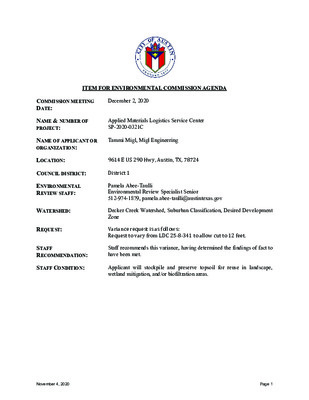
ITEM FOR ENVIRONMENTAL COMMISSION AGENDA COMMISSION MEETING DATE: December 2, 2020 NAME & NUMBER OF PROJECT: Applied Materials Logistics Service Center SP-2020-0321C NAME OF APPLICANT OR ORGANIZATION: Tammi Migl, Migl Engineering LOCATION: 9614 E US 290 Hwy, Austin, TX, 78724 COUNCIL DISTRICT: District 1 ENVIRONMENTAL REVIEW STAFF: WATERSHED: REQUEST: STAFF RECOMMENDATION: STAFF CONDITION: Pamela Abee-Taulli Environmental Review Specialist Senior 512-974-1879, pamela.abee-taulli@austintexas.gov Decker Creek Watershed, Suburban Classification, Desired Development Zone Variance request is as follows: Request to vary from LDC 25-8-341 to allow cut to 12 feet. Staff recommends this variance, having determined the findings of fact to have been met. Applicant will stockpile and preserve topsoil for reuse in landscape, wetland mitigation, and/or biofiltration areas. November 4, 2020Page 1 Development Services Department Staff Recommendations Concerning Required Findings Project Name: Ordinance Standard: Watershed Protection Ordinance Variance Request: Applied Materials Logistics Service Center Vary from LDC 25-8-341 to allow cut to 12 feet Include an explanation with each applicable finding of fact. A. Land Use Commission variance determinations from Chapter 25-8-41 of the City Code: 1. The requirement will deprive the applicant of a privilege available to owners of similarly situated property with approximately contemporaneous development subject to similar code requirements. Yes The applicant intends to combine multiple warehouses into one consolidated warehouse at this location. Automated robotic equipment and human operated wheeled equipment to be used in the facility require a consistent floor elevation. The applicant proposes 699,000 square feet of warehouse space with a consistent floor elevation, as well as loading docks, fire lanes, and parking that will be constructed at elevations appropriate for the warehouse finished floor elevation. A consistent floor elevation is necessary for this type of automated warehouse. The applicant proposes to construct this facility on a site with minimal slopes (2% to 5%). However, the size of the warehouse necessitates cut up to 12 feet to achieve a consistent finished floor elevation. The applicant proposes cut up to 12 feet, which has been minimized by use of a retaining wall, as shown in Exhibit 1. 2. The variance: a) Is not necessitated by the scale, layout, construction method, or other design decision made by the applicant, unless the design decision provides greater overall environmental protection than is achievable without the variance; Yes The materials handling needs of the warehousing process, and inclusion of a large automated storage solution within the warehouse, require a single building with a uniform finished floor elevation. November 4, 2020Page 2 The finished floor elevation was based on 1) working around the CEF, 2) maintaining circulation to the existing campus, and 3) keeping the truck court slopes minimal for maneuverability. Cut to 12 feet is necessary in the south truck bay to maintain a standard 4-foot dock height. In addition, the applicant has selected a relatively flat site for the proposed warehouse. The selection of this site has helped to minimize the required grading. b) Is the minimum deviation from the code requirement necessary to allow a reasonable use of the property; A retaining wall on the west side, parallel to Giles Yes Lane, minimizes the extent of cut adjacent to the building. The truck court grades slope with the natural contours as much as possible while maintaining minimal slopes to facilitate the maneuverability and circulation of the truck traffic. The applicant has selected a relatively flat site for the proposed warehouse, helping to minimize the required grading. c) Does not create a significant probability of harmful environmental consequences. Yes The development process does not pose a probability of harmful environmental consequences. The site is relatively flat, with a slope 2-5%. Based on the gentle slopes and the proposed construction activities, standard temporary and permanent erosion and sedimentation controls will contain sediment in accordance with Code and Criteria requirements. The project will not impact any heritage trees. No floodplain or creek buffers exist within or adjacent to the limits of construction. The project has been designed to incorporate and enhance an existing wetland critical environmental feature. The wetland is the site of an old stock pond and is very low in vigor, density and diversity. Proposed enhancements to the wetland area exceed the mitigation requirement. 3. Development with the variance will result in water quality that is at least equal to the water quality achievable without the variance. Yes The development process does not pose a probability of harming water quality. B. The Land Use Commission may grant a variance from a requirement of Section 25-8-422 (Water Supply Suburban Water Quality Transition Zone), Section 25-8-452 (Water Supply Rural Water Quality Transition Zone), Section 25-8-482 (Barton Springs Zone November 4, 2020Page 3 Water Quality Transition Zone), Section 25-8-368 (Restrictions on Development Impacting Lake Austin, Lady Bird Lake, and Lake Walter E. Long), or Article 7, Division 1 ( Critical Water Quality Zone Restrictions ), after determining that:: 1. The criteria for granting a variance in Subsection (A) are met; 2. 3. Yes / No NA Yes / No NA Yes / No NA The requirement for which a variance is requested prevents a reasonable, economic use of the entire property; The variance is the minimum deviation from the code requirement necessary to allow a reasonable, economic use of the entire property. Staff Determination: Staff determines that the findings of fact have / have not been met. Staff recommends the following condition: Environmental Reviewer (DSD) _____________________________ (print name) Date: 11/3/20 Environmental Review Manager (DSD) _____________________________ (print name) Date: 11/3/2020 Environmental Officer (WPD) _____________________________ (print name) 11/13/2020 Date: __________ November 4, 2020Page 4 GRADING EXHIBIT RETAINING WALL CUT TO 12’ Exhibit 1November 4, 2020Page 5 ENVIRONMENTAL COMMISSION VARIANCE APPLICATION FORM PROJECT DESCRIPTION Applicant Contact Information Name of Applicant Street Address City State ZIP Code Work Phone E-Mail Address Case Name Case Number Migl Engineering and Consulting, PLLC 9600 Escarpment Blvd, Suite 745-174 Austin, TX 78749 512-750-0440 tammi@miglengineering.com Variance Case Information Applied Materials Logistics Service Center SP-2020-0321C 9700 East US Hwy 290 Pamela Abee-Taulli Address or Location Environmental Reviewer Name Environmental Resource Management Reviewer Name Applicable Ordinance Watershed Name Decker Watershed Protection Ordinance Watershed Classification ☐Urban X Suburban ☐Water Supply Suburban ☐Water Supply Rural ☐ Barton Springs Zone City of Austin | Environmental Commission Variance Application Guide 1 November 4, 2020Page 1 Edwards Aquifer Recharge Zone ☐ Barton Springs Segment ☐ Northern Edwards Segment X Not in Edwards Aquifer Zones Edwards Aquifer Contributing Zone Distance to Nearest Classified Waterway ☐ Yes X No 2,500 ft to Decker Creek Water and Waste Water service to be provided by Austin Water Utility The variance request is as follows (Cite code references): Variance from LDC Section 25-8-341 – Cut Requirements limiting cut to less than four feet of depth. Existing 2,196,631 50.43 47.63 Proposed (total after development) 3,061,581 70.28 66.39 The project is located on the Applied Materials Harris Branch Campus. The Logistics Service Center (LSC) project will be developed as a Unified Development with the portion of the campus located south of Lake Bluebonnet; the Gross Site Area is 105.87 acres. Approximately 21.63 acres of the 44.5‐acre limits of construction are undeveloped; the remaining area consists of overflow parking for the existing manufacturing/ office buildings. The site is located within the Decker Watershed, which is classified as a suburban watershed. No portion of the project limits of construction is located within the limits of the 100‐year floodplain or Critical Water Quality Zone. Topography of the project limits of construction ranges from 610 to 634 feet AMSL. Drainage on the site generally slopes to the east at 2‐5%. Undeveloped portions of the site consist of grasslands with very few trees. No heritage trees are located within the limits of construction. A stock tank is located on the eastern portion of the undeveloped area; the stock tank has been classified as a wetland CEF and will be protected with this project. The existing CEF is very low in vigor, diversity, and density and will be revegetated with the LSC project with a diverse selection of plants. City of Austin | Environmental Commission Variance Application Guide 2 Request Impervious cover square footage: acreage: percentage: Provide general description of the property (slope range, elevation range, summary of vegetation / trees, summary of the geology, CWQZ, WQTZ, CEFs, floodplain, heritage trees, any other notable or outstanding characteristics of the property) November 4, 2020Page 2 Clearly indicate in what way the proposed project does not comply with current Code (include maps and exhibits) Construction of the LSC project will require limited areas of cut exceeding four (4) feet. Cut between 4’ and 8’ will be limited to an area within the north and south truck courts totaling 1.5 acres, which is 3.38 percent of the 45‐acre limits of construction and 1.44 percent of the gross site area. Cut between 8’ and 12’ will be limited to a 0.87‐acre area within the south truck court, which is 1.93 percent of the 45‐acre limits of construction and 0.82 percent of the gross site area. FINDINGS OF FACT As required in LDC Section 25‐8‐41, in order to grant a variance the Land Use Commission must make the following findings of fact: Include an explanation with each applicable finding of fact. Project: Applied Materials Logistics Service Center Ordinance: 25‐8‐341 A. Land Use Commission variance determinations from Chapter 25‐8‐41 of the City Code: 1. The requirement will deprive the applicant of a privilege available to owners of similarly situated property with approximately contemporaneous development subject to similar code requirements. YES / No The Logistics Service Center (LSC) will include construction of a 729,000 square foot single-story building consisting of 699,000 square feet of warehouse and 30,000 square feet of supporting office space. The project will consolidate seven (7) off-site logistics facilities into one central warehouse and distribution service center. The variance request is common for large facilities of this type in this part of Austin; without this variance the Applicant would be deprived of privileges available to owners of similar projects. The building configuration and placement on the property was based on the location of a wetland Critical Environmental Feature (CEF) that exists on the site. The building was designed to wrap around this CEF so that the wetland could be preserved to the maximum extent possible. Working around the CEF dictated the buildable area for the significant building footprint. City of Austin | Environmental Commission Variance Application Guide 3 November 4, 2020Page 3 The variance: a) The materials handling needs of the warehousing process and inclusion of a large automated storage solution within the warehouse requires the finished floor elevation to be a uniform elevation. The finished floor elevation was based on preserving the wetland and maintaining grades in the area adjacent to the CEF as much as possible. The finished floor elevation of the LSC was also based on the need for the north shipping/ receiving dock to tie-into the existing Applied campus at closely matching elevations. The LSC provides warehousing and distribution support for the six (6) existing manufacturing buildings located on the campus making the seamless connection into the existing campus extremely important for site circulation. For the aforementioned reasons of working around the CEF and maintaining circulation to the existing campus, the warehouse finished floor elevation was set at 625. The north and south truck courts are at an elevation of 621 to maintain a standard 4’ dock height. Areas of cut in excess of 4’ are limited to the two truck courts due to required dock heights. The primary area of cut is near the southwest corner of the building within the south truck court. 2. Is not necessitated by the scale, layout, construction method, or other design decision made by the applicant, unless the design decision provides greater overall environmental protection than is achievable without the variance; YES / No [provide summary of justification for determination] The building configuration and placement on the property was dictated by the location of a wetland Critical Environmental Feature (CEF) that exists on the site. The building was designed to wrap around this CEF so that the wetland could be preserved to the maximum extent possible. Working around the CEF dictated the buildable area for the significant building footprint. The scale, layout, and overall design of the site is based on the need to consolidate seven (7) off-site facilities to one central on-site location to reduce vehicle miles and increase the efficiency of the LSC. This consolidation results in greater overall environmental protection than is achievable without the variance because approximately 84,000 vehicle miles are eliminated annually, yielding: Less traffic congestion; Substantial air quality benefits due to the reduction in carbon dioxide and greenhouse gas emissions; Water quality benefits due to the reduction in hydrocarbons, heavy metals and TSS from fuel, oil and particle laden runoff from roadways; and Reduced noise pollution The building will consist of a 729,000 square foot warehouse with 9 dock doors and a truck court on the south side of the building and 38 dock doors and a truck court on the north side of the building. The materials handling needs of the warehousing process and inclusion of a large City of Austin | Environmental Commission Variance Application Guide 4 November 4, 2020Page 4 b) c) automated storage solution within the warehouse requires a uniform finished floor elevation similarly found in other warehouses. The building type, layout, and ingress/egress features are based upon the materials handling needs of the warehousing, shipping, and receiving processes. This layout is similar to other such facilities in the Austin area and we feel that the variance does not provide special privilege not enjoyed by other similarly situated properties and similarity timed development. Is the minimum deviation from the code requirement necessary to allow a reasonable use of the property; YES / No A retaining wall is proposed parallel to Giles Lane a horizontal distance of approximately fifteen (15) feet from the western edge of the building foundation. This retaining wall is an integral part of the slab on grade building foundation and acts as a vertical moisture retarder. This retaining wall also serves to minimize the extent of the cut to the 15’ immediately adjacent to the building foundation on the west side; the grade at the top of the wall varies and matches existing grades. Although cut areas in the south and north truck court could not be limited due to the standard 4’ dock height required, the truck court grades slope with the natural contours as much as possible while maintaining minimal slopes to facilitate the maneuverability and circulation of the truck traffic. Does not create a significant probability of harmful environmental consequences. YES / No The proposed LSC project does not create a significant probability of harmful environmental consequences. The project will not impact any heritage trees. No floodplain or creek buffers exist within or adjacent to the limits of construction. An old stock pond with a fringe wetland exists within the limits of construction and has been classified at a wetland CEF. This CEF is very low in vigor, density and diversity (according to site visits and review by Horizon Environmental Services, Inc and corroborated by Watershed Protection staff). The project has been designed to incorporate and enhance the existing wetland CEF. The drainage of the site has been designed to increase the contributing drainage area to the wetland. The wetland area will be improved by not only enlarging the permanent pool but also creating several littoral shelves and vegetated benches. The littoral shelves and benches will create a safe haven, breeding place, and healthy habitat for fish and indigenous wildlife such as birds, dragonflies, and frogs around the wetland. Mosquitofish will be introduced to the wetland to control the mosquito population. Water shading plants will provide shade for aquatic life and cool water temperatures. City of Austin | Environmental Commission Variance Application Guide 5 November 4, 2020Page 5 Mitigation for encroachment within the 150’ wetland setback is required at a ratio of 1:1; 141,800 mitigation points are required. Proposed enhancements to the wetland area exceed the mitigation requirement; 152,817 mitigation points have been provided based on plantings alone. Trees, grasses and shrubs proposed increase the biodiversity of the area and will survive with varying levels of water. Species that produce berries and nuts, and pollenating plants have been selected to provide benefits to the wildlife including birds, and pollinators such as bees and butterflies. The project proposes to add three (3) biofiltration ponds and a partial sedimentation/ filtration pond; all City of Austin water quality regulations have been met. An Integrated Pest Management Plan will be developed for the areas of campus that contribute to the three (3) proposed biofiltration ponds. The proposed LSC project results in a significant reduction in miles traveled by bringing seven (7) off-site facilities to one central on-site location. This 84,000 mile-per-year reduction not only results in less traffic congestion, but also results in substantial air quality benefits due to the reduction in carbon dioxide and greenhouse gas emissions; water quality benefits due to the reduction in hydrocarbons, heavy metals and TSS from fuel, oil and particle laden runoff from roadways; and also, a reduction in noise pollution. 3. Development with the variance will result in water quality that is at least equal to the water quality achievable without the variance. YES / No Yes, the proposed LSC project will provide equal or better water quality than would have resulted if the development had proceeded without the variance. With the addition of three (3) biofiltration ponds and a partial sedimentation/ filtration pond, all City of Austin water quality regulations have been met. In addition, the project has been designed to incorporate and enhance the existing wetland CEF. The CEF is an old stock pond with a fringe wetland around its bank and a contributing area of approximately 3.2 acres. Drainage of the site has been designed to increase the contributing drainage area to the wetland to 15 acres. Biofiltration ponds have been designed on both the east and west side of the wetland each with two sedimentation basins and a biofiltration basin. The filtration underdrains will be pumped to the wetland. In addition, condensate recovery tanks will also drain to the wetland ensuring a continual source of water to the wetland plants. The wetland CEF provides another layer of water quality to the contributing drainage area by extending biological contact time with sustainable aquatic species and vegetation. The wetland area will be improved by not only enlarging the permanent pool but also creating several littoral shelves and vegetated benches. The littoral shelves and benches will increase the nutrient uptake and also create a safe haven, breeding place, and healthy habitat for fish and City of Austin | Environmental Commission Variance Application Guide 6 November 4, 2020Page 6 indigenous wildlife such as birds, dragonflies, and frogs around the wetland. Mosquitofish will be introduced to the wetland to control the mosquito population. Water shading plants will not only provide shade for aquatic life and cool water temperatures, but will also provide an additional form of filtration by removing nitrogen and phosphates. Mitigation for encroachment within the 150’ wetland setback is required at a ratio of 1:1; 141,800 mitigation points are required. Proposed enhancements to the wetland area exceed the mitigation requirement; 152,817 mitigation points have been provided based on plantings alone. Trees, grasses and shrubs proposed increase the biodiversity of the area and will survive with varying levels of water. Species that produce berries and nuts, and pollenating plants have been selected to provide benefits to the wildlife including birds, and pollinators such as bees and butterflies. As previously mentioned, four (4) water quality ponds are proposed with the LSC project. Two (2) biofiltration ponds will flank the wetland as discussed above, a third biofiltration pond is proposed north of the LSC near Giles Lane and a partial/sedimentation filtration pond is proposed southeast of the LSC near US Hwy 290. Similar to the biofiltration ponds adjacent to the wetlands, the biofiltration pond north of the LSC will have plant diversity and provide ecological benefits beyond the water quality benchmark. An Integrated Pest Management Plan will be developed for the areas of campus that contribute to the three (3) proposed biofiltration ponds. The proposed LSC project results in a significant reduction in miles traveled by bringing seven (7) off-site facilities to one central on-site location. This 84,000 mile-per-year reduction not only results in less traffic congestion, but also results in substantial air quality benefits due to the reduction in carbon dioxide and greenhouse gas emissions; water quality benefits due to the reduction in hydrocarbons, heavy metals and TSS from fuel, oil and particle laden runoff from roadways; and also, a reduction in noise pollution. B. Additional Land Use Commission variance determinations for a requirement of Section 25‐8‐422 (Water Quality Transition Zone), Section 25‐8‐452 (Water Quality Transition Zone), Article 7, Division 1 (Critical Water Quality Zone Restrictions), or Section 25‐8‐368 (Restrictions on Development Impacting Lake Austin, Lady Bird Lake, and Lake Walter E. Long):…. NA The criteria for granting a variance in Subsection (A) are met; Yes / No [provide summary of justification for determination] The requirement for which a variance is requested prevents a reasonable, economic use of the entire property; Yes / No [provide summary of justification for determination] The variance is the minimum deviation from the code requirement necessary to allow a reasonable, economic use of the entire property. City of Austin | Environmental Commission Variance Application Guide 7 1. 2. 3. November 4, 2020Page 7 Yes / No [provide summary of justification for determination] **Variance approval requires all above affirmative findings. City of Austin | Environmental Commission Variance Application Guide 8 November 4, 2020Page 8 A Exhibits for Commission Variance o Aerial photos of the site o Site photos o Aerial photos of the vicinity o Context Map—A map illustrating the subject property in relation to developments in the vicinity to include nearby major streets and waterways o Topographic Map ‐ A topographic map is recommended if a significant grade change on the subject site exists or if there is a significant difference in grade in relation to adjacent properties. o For cut/fill variances, a plan sheet showing areas and depth of cut/fill with topographic elevations. o Site plan showing existing conditions if development exists currently on the property o Proposed Site Plan‐ full size electronic or at least legible 11x17 showing proposed development, include tree survey if required as part of site or subdivision plan o Environmental Map – A map that shows pertinent features including Floodplain, CWQZ, WQTZ, CEFs, Setbacks, Recharge Zone, etc. o An Environmental Resource Inventory pursuant to ECM 1.3.0 (if required by 25‐8‐121) o Applicant’s variance request letter City of Austin | Environmental Commission Variance Application Guide 9 November 4, 2020Page 9 LOC LOC LOC LOC LOC LOC LOC LOC LOC LOC 0 15' 30' 60' Scale: 1" = 30' ZONING : P-CO ZONING : DR ZONING : DR GILES LANE (AKA GILES ROAD) (R.O.W. VARIES) LOC LOC 1.0% LOC LOC LOC C O L LOC GILES LANE (AKA GILES ROAD) (R.O.W. VARIES) LOC LOC LOC LOC LOC LOC L O C L O C ZONING : DR GILES LANE (AKA GILES ROAD) (R.O.W. VARIES) LOC LOC LOC 0.67% % 5 . 0 LOC % 0 1 . % 0 . 6 % 0 6 . L O C L O C L O C 6.0% 2 B S S U T T I O O L N R D I E Y N LOC LOC G LOC LOC L O C L O C L O C L O C W M W M B F P L O C H.P. H.P. H . P . C O L L O C H.P. L O C L O C P PM M H.P. C E F S E T B A C K 1 5 0.0' L O C L O C U . S . ( R H I L O C . ( G O H W . W B W . V F A R Y ) 2 A L O C R I E 9 0 S ) L O C 2.6% 2.0% H P . . 0.55% . L P . H P . . C O L L O C C O L L O C LO C C O L C L O L O C C O L L O C L O C C O L C O L C O L . g w d S B E C S L - T A M A 9 0 0 0 2 1 X * . . - - g w d R E D R O B C S L T A M A 9 0 0 . 0 2 1 * g w d . P M E T - O T P C S L - T A M A 9 0 0 . 0 2 1 X * g w d . 2 - S B E C S L - T A M A 9 0 0 . 0 2 1 X * . g w d N A L P R O O L F - T A M A * . g w d S B P C S L - T A M A 9 0 0 . 0 2 1 X * : S F E R X T U C : T U O Y A L R K R A M : Y B M P 4 2 2 2 : : 2 0 2 0 2 / 0 2 / 8 : I I D E V A S T S A L g w d . T B H X E T U C S H W - T A M A 9 0 0 . 0 2 1 0 \ S T B H X E L L I F - T U C S T B H X E D A C 8 0 C S L T A M A 9 0 0 I \ I \ \ I I . \ I 0 2 1 0 G N R E E N G N E L G M \ x o B I I \ : G : E L F I . g n p E C A P S o g o L L G M I * : S E G A M I L O C L O C L O C H . P . L.P. L O C L . P . H.P. L . P . H . P . H . P . L . P . L O C . P . H L.P. L O C LOC LOC LOC LOC LOC LOC C O L C O L C O L C O L L O C L O C C O L LOC LOC L C O O C L L O C C O L L O C C O L LOC L O C C O L L O C C O L L O C Elevations Table Number Minimum Elevation Maximum Elevation AREA (SF) % LOC % UDA Color 1 2 -8.00 -12.00 -4.00 -8.01 66322 37892 3.38% 1.44% 1.93% 0.82% OCTOBER 19, 2020 ' D M O C E R I S N O S V E R I E T A D . O N I S L A R E T A M D E I L P P A 0 9 2 Y W H S U T S A E 0 0 7 9 4 2 7 8 7 X T , N I T S U A 0 9 2 Y W H S U T S A E 0 0 7 9 4 2 7 8 7 X T , N I T S U A I R E T N E C E C V R E S S C I T S G O L N I T S U A I I S L A R E T A M D E I L P P A T C E J O R P T N E I L C E L T I T T E E H S I T I B H X E T U C PROJECT NO. 0120.009 SHEET NO. Ex-02 R Know what's below. Call before you dig. CAUTION - ELECTRICITY PRESENT THE GENERAL CONTRACTOR AND ALL SUBCONTRACTORS THAT ENTER OR WORK ON THIS PROJECT ARE RESPONSIBLE FOR LOCATING, USING ONE-CALL OR THE ELECTRIC UTILITIES THEMSELVES, ALL OVERHEAD AND UNDERGROUND ELECTRICAL OF ANY NATURE AND FOR SAFEGUARDING ALL PERSONNEL ON THIS PROJECT, INCLUDING ANY OFF-SITE WORK AREAS SHOWN ON THE PLAN, FROM ANY INTERFERENCE WITH THE ELECTRIC LINES OR FROM DAMAGING, DIGGING UP OR UNCOVERING THE ELECTRIC LINES, GETTING A LADDER IN HARMS WAY OR ANY OTHER ACTIVITY OF ANY NATURE THAT COULD HARM ANY INDIVIDUAL IN ANY MANNER. THIS RESPONSIBILITY HEREBY REMOVES MIGL ENGINEERING AND CONSULTING AND THE OWNER FROM ANY LIABILITY OF ANY NATURE. November 4, 2020Page 10 LOC LOC LOC LOC LOC LOC LOC LOC GILES LA. (122' ROW) LOC C O L LOC LOC LOC LOC LOC LOC LOC L O C L O C 0 100' 200' 400' Scale: 1" = 200' LOC LOC L O C L O C L O C L O C LOC L O C WETLANDS CEF L O C 150' CEF SETBACK C O L L O C LO C C L O C O L L O C C O L LOC LOC LOC LOC L O C L O C U S H W Y 2 L O C 9 0 E A S T L O C C O L C O L L C O C O L L O C C O L C O L L O C C L O O L C C L O O L C C L O O L C C L O O L C C L O O L C C L O O L C C L O O L C C L O O L C C L O O L C I N A L P E T S L L A R E V O G N T S X E I I : T U O Y A L R K R A M : Y B M P 1 1 : 9 0 : 2 1 0 2 0 2 / 3 9 / : D E V A S T S A L I . - g w d E T S E C S L T A M A 9 0 0 . \ \ 0 2 1 S N A L P D A C 8 0 \ C S L T A M A 9 0 0 . 0 2 1 0 \ G N R E E N G N E L G M \ x o B I I I \ : G : E L I F . - g w d R E D R O B C S L T A M A 9 0 0 . . 0 2 1 * g w d S B E C S L - T A M A 9 0 0 . 0 2 1 X * g w d . 2 - S B E C S L - T A M A 9 0 0 0 2 1 X * : . S F E R X g n p . E C A P S o g o L L G M I * : S E G A M I LEGEND NOT WITHIN UDA OR PART OF THIS APPLICATION SEPTEMBER 9, 2020 ' D M O C E R I S N O S V E R I E T A D . O N I S L A R E T A M D E I L P P A 0 9 2 Y W H S U T S A E 0 0 7 9 4 2 7 8 7 X T , N I T S U A 0 9 2 Y W H S U T S A E 0 0 7 9 4 2 7 8 7 X T , N I T S U A I R E T N E C E C V R E S S C I T S G O L N I T S U A I I S L A R E T A M D E I L P P A T C E J O R P G N I T S X E I L L A R E V O N A L P E T I S T N E I L C E L T I T T E E H S R Know what's below. Call before you dig. CAUTION - ELECTRICITY PRESENT THE GENERAL CONTRACTOR AND ALL SUBCONTRACTORS THAT ENTER OR WORK ON THIS PROJECT ARE RESPONSIBLE FOR LOCATING, USING ONE-CALL OR THE ELECTRIC UTILITIES THEMSELVES, ALL OVERHEAD AND UNDERGROUND ELECTRICAL OF ANY NATURE AND FOR SAFEGUARDING ALL PERSONNEL ON THIS PROJECT, INCLUDING ANY OFF-SITE WORK AREAS SHOWN ON THE PLAN, FROM ANY INTERFERENCE WITH THE ELECTRIC LINES OR FROM DAMAGING, DIGGING UP OR UNCOVERING THE ELECTRIC LINES, GETTING A LADDER IN HARMS WAY OR ANY OTHER ACTIVITY OF ANY NATURE THAT COULD HARM ANY INDIVIDUAL IN ANY MANNER. THIS RESPONSIBILITY HEREBY REMOVES MIGL ENGINEERING AND CONSULTING AND THE OWNER FROM ANY LIABILITY OF ANY NATURE. SITE PLAN RELEASE . SP-2020- FILE NUMBER: ______________________ EXPIRATION DATE: ________________ CASE MANAGER: ______________________ APPLICATION DATE: ____________ APPROVED ADMINISTRATIVELY ON: ____________________________________ APPROVED BY PLANNING COMMISSION ON: _____________________________ APPROVED BY CITY COUNCIL ON: ______________________________________ Under Section _____ of Chapter _____ of the Austin City Code. Signing for Director, Development Services Department DATE OF RELEASE: _____________________ ZONING: ______________________ Rev. 1 ___________________________ Correction 1: ___________________________ Rev. 2 ___________________________ Correction 2: ___________________________ Rev. 3 ___________________________ Correction 3: ___________________________ Release of this application does not constitute a verification of all data, information and calculations supplied by the Applicant. The Engineer of record is solely responsible for the completeness, accuracy and adequacy of His/Her submittal, whether or not the application is reviewed for code compliance by City Engineers. PROJECT NO. 0120.009 SHEET NO. C10 10 OF 119 November 4, 2020Page 11 CITY OF AUSTIN (ETJ) LANDUSE: LANDFILL CITY OF AUSTIN (FULL PURPOSE) LANDUSE: LANDFILL CITY OF AUSTIN (ETJ) CITY OF AUSTIN (FULL PURPOSE) LANDUSE: LANDFILL CITY OF AUSTIN (ETJ) CITY OF AUSTIN (FULL PURPOSE) CITY OF AUSTIN (ETJ) CITY OF AUSTIN (FULL PURPOSE) GILES LA. (122' ROW) LOC LOC LOC LOC LOC LOC LOC C O L LOC LOC L O C F L L F L O C F L F L L F LOC LOC L O C L O C FL L F L O C C O L L O C PROPOSED LOGISTICS SERVICE 4 0 0 0 . ' CENTER 729,000 SF L F P PM M FL FL FL FL 9 5 0 0 . ' L F F L L F F L EXISTING WETLANDS CEF PROPOSED WETLANDS CEF PROPOSED WETLANDS CEF SETBACK L O C L O C U S H W Y 2 9 0 E A S T L O C LANDUSE: LANDFILL CITY OF AUSTIN (ETJ) CITY OF AUSTIN (FULL PURPOSE) LOC L O C LOC FL FL FL FL LOC LOC L O C LOC FL FL FL FL FL L F FL E B X I S U I L T I 3 1 N D I N G G F L F L L F C O L C O L FL FL F L F L F L F L FL FL LO C C L O C O L FL FL L F F L F L F L L F F L L O C F L F L F L C O L FL FL L F L F F L E B X I S U I L T I 3 2 N D I N G G L F FL FL FL FL FL FL LOC FL LOC LOC L O C L O C L F F L C O L C O L EXISTING BUILDING 33 FL FL L O L C O C LOC FL C O L L O C APPLIED MATERIALS SEC 1 LOT ZONING: LI-PUD C O L L O C C O L L O C U P B L L P U A E E K R B E O N N E T E X I S B U 3 4 I L T I N G D I N G L F L F L F FL FL C O L L F F L L F L F L O C C O L F F L L L F F L C O L L O C F F L L L F F L C O L L O C FL L O C C O L L O C C O L L O B L U E L W A E K R B E O N N E T L O C C O L L O C C O L L O C C O L g w d . s k c a b t e S _ y a w r e t a W * . - g w d T U P C S L - T A M A 9 0 0 . 0 2 1 X * I . g w d D R G C S L - T A M A 9 0 0 . 0 2 1 X * g w d . . 2 - S B E C S L - T A M A 9 0 0 0 2 1 X * g w d S B E C S L - T A M A 9 0 0 . . . 0 2 1 X * g w d S B P C S L - T A M A 9 0 0 . 0 2 1 X * . - g w d R E D R O B C S L T A M A 9 0 0 . 0 2 1 * g w d . P A M Y E K * g w d . N A L P R O O L F - T A M A * : S F E R X I N A L P E T S L L A R E V O D E S O P O R P : T U O Y A L R K R A M : Y B M P 5 2 3 1 : : 5 0 2 0 2 / 3 9 / : D E V A S T S A L . g w d n a p e l t i S C S L T A M A 9 0 0 . \ \ 0 2 1 S N A L P D A C 8 0 \ C S L T A M A 9 0 0 . 0 2 1 0 \ G N R E E N G N E L G M \ x o B I I I \ : G : E L I F g n p . E C A P S o g o L L G M I * : S E G A M I 0 100' 200' 400' Scale: 1" = 200' LEGEND NOT WITHIN UDA OR PART OF THIS APPLICATION SEPTEMBER 9, 2020 ' D M O C E R I S N O S V E R I E T A D . O N I S L A R E T A M D E I L P P A 0 9 2 Y W H S U T S A E 0 0 7 9 4 2 7 8 7 X T , N I T S U A 0 9 2 Y W H S U T S A E 0 0 7 9 4 2 7 8 7 X T , N I T S U A I R E T N E C E C V R E S S C I T S G O L N I T S U A I I S L A R E T A M D E I L P P A T C E J O R P D E S O P O R P L L A R E V O N A L P E T I S T N E I L C E L T I T T E E H S R Know what's below. Call before you dig. CAUTION - ELECTRICITY PRESENT THE GENERAL CONTRACTOR AND ALL SUBCONTRACTORS THAT ENTER OR WORK ON THIS PROJECT ARE RESPONSIBLE FOR LOCATING, USING ONE-CALL OR THE ELECTRIC UTILITIES THEMSELVES, ALL OVERHEAD AND UNDERGROUND ELECTRICAL OF ANY NATURE AND FOR SAFEGUARDING ALL PERSONNEL ON THIS PROJECT, INCLUDING ANY OFF-SITE WORK AREAS SHOWN ON THE PLAN, FROM ANY INTERFERENCE WITH THE ELECTRIC LINES OR FROM DAMAGING, DIGGING UP OR UNCOVERING THE ELECTRIC LINES, GETTING A LADDER IN HARMS WAY OR ANY OTHER ACTIVITY OF ANY NATURE THAT COULD HARM ANY INDIVIDUAL IN ANY MANNER. THIS RESPONSIBILITY HEREBY REMOVES MIGL ENGINEERING AND CONSULTING AND THE OWNER FROM ANY LIABILITY OF ANY NATURE. SITE PLAN RELEASE . SP-2020- FILE NUMBER: ______________________ EXPIRATION DATE: ________________ CASE MANAGER: ______________________ APPLICATION DATE: ____________ APPROVED ADMINISTRATIVELY ON: ____________________________________ APPROVED BY PLANNING COMMISSION ON: _____________________________ APPROVED BY CITY COUNCIL ON: ______________________________________ Under Section _____ of Chapter _____ of the Austin City Code. Signing for Director, Development Services Department DATE OF RELEASE: _____________________ ZONING: ______________________ Rev. 1 ___________________________ Correction 1: ___________________________ Rev. 2 ___________________________ Correction 2: ___________________________ Rev. 3 ___________________________ Correction 3: ___________________________ Release of this application does not constitute a verification of all data, information and calculations supplied by the Applicant. The Engineer of record is solely responsible for the completeness, accuracy and adequacy of His/Her submittal, whether or not the application is reviewed for code compliance by City Engineers. PROJECT NO. 0120.009 SHEET NO. C11 11 OF 119 November 4, 2020Page 12 November 4, 2020Page 13 Applied Materials Austin Texas Campus November 4, 2020Page 14 PHOTO 1 Photo of wetland CEF (W-1) PHOTO 2 Vegetation in wetland CEF (W-1) PHOTO 3 Typical site photo PHOTO 4 Typical site photo 190275-001ERI Photopage.docx November 4, 2020Page 15 Case No.: (City use only) Environmental Resource Inventory For the City of Austin Related to LDC 25-8-121, City Code 30-5-121, ECM 1.3.0 & 1.10.0 The ERI is required for projects that meet one or more of the criteria listed in LDC 25-8-121(A), City Code 30-5-121(A). 1. SITE/PROJECT NAME: Applied Materials Logistics Service Center 2. COUNTY APPRAISAL DISTRICT PROPERTY ID (#’s): 227119 3. ADDRESS/LOCATION OF PROJECT: 10033 Giles Lane, Austin, Travis County 4. WATERSHED: Decker Creek 5. THIS SITE IS WITHIN THE (Check all that apply) Edwards Aquifer Recharge Zone* (See note below) .................. (cid:133)YES (cid:133)No Edwards Aquifer Contributing Zone*.................................. (cid:133)YES (cid:133)No Edwards Aquifer 1500 ft Verification Zone* ....................... (cid:133)YES (cid:133)No Barton Spring Zone* .......................................................... (cid:133)YES (cid:133)No *(as defined by the City of Austin – LDC 25-8-2 or City Code 30-5-2) ✔ ✔ ✔ ✔ Note: If the property is over the Edwards Aquifer Recharge zone, the Hydrogeologic Report and karst surveys must be completed and signed by a Professional Geoscientist Licensed in the State of Texas. 6. DOES THIS PROJECT PROPOSE FLOODPLAIN MODIFICATION?.......(cid:133)YES** (cid:133)NO ✔ If yes, then check all that apply: (cid:13) (1) The floodplain modifications proposed are necessary to protect the public health and safety; (cid:13) (2) The floodplain modifications proposed would provide a significant, demonstrable environmental benefit, as determined by a functional assessment of floodplain health as prescribed by the Environmental Criteria Manual (ECM), or (cid:13) (3) The floodplain modifications proposed are necessary for development allowed in the critical water quality zone under LDC 25-8-261 or 25-8-262, City Code 30-5-261 or 30-5-262. (cid:13) (4) The floodplain modifications proposed are outside of the Critical Water Quality Zone in an area determined to be in poor or fair condition by a functional assessment of floodplain health. ** If yes, then a functional assessment must be completed and attached to the ERI (see ECM 1.7 and Appendix X for forms and guidance) unless conditions 1 or 3 above apply. 7. IF THE SITE IS WITHIN AN URBAN OR SUBURBAN WATERSHED, DOES THIS PROJECT PROPOSE A UTILITY LINE PARALLEL TO AND WITHIN THE CRITICAL WATER QUALITY ZONE? ......................................................... (cid:133)YES*** (cid:133)NO ✔ ***If yes, then riparian restoration is required by LDC 25-8-261(E) or City Code 30-5-261(E) and a functional assessment must be completed and attached to the ERI (see ECM1.5 and Appendix X for forms and guidance). 1 8. There is a total of (#’s) Critical Environmental Feature(s)(CEFs) on or within150 feet of the project site. If CEF(s) are present, attach a detailed DESCRIPTION of the CEF(s), color PHOTOGRAPHS, the CEF WORKSHEET and provide DESCRIPTIONS of the proposed CEF buffer(s) and/or wetland mitigation. Provide the number of each type of CEFs on or within 150 feet of the site (Please provide the number of CEFs ): November 4, 2020Page 16 (#’s) Spring(s)/Seep(s) (#’s) Point Recharge Feature(s) (#’s) Bluff(s) (#’s) Canyon Rimrock(s) (#’s) Wetland(s) 1 Note: Standard buffers for CEFs are 150 feet, with a maximum of 300 feet for point recharge features. Except for wetlands, if the standard buffer is not provided, you must provide a written request for an administrative variance from LDC 25-8-281(C)(1) and provide written findings of fact to support your request. Request forms for administrative variances from requirements stated in LDC 25-8-281 are available from Watershed Protection Department. 9. The following site maps are attached at the end of this report (Check all that apply and provide): All ERI reports must include: (cid:13) Site Specific Geologic Map with 2-ft Topography ✔ (cid:13) Historic Aerial Photo of the Site ✔ (cid:13) Site Soil Map ✔ (cid:13) Critical Environmental Features and Well Location Map on current ✔ Aerial Photo with 2-ft Topography Only if present on site (Maps can be combined): (cid:13) Edwards Aquifer Recharge Zone with the 1500-ft Verification Zone(cid:3) (cid:3) (cid:3) (Only if site is over or within 1500 feet the recharge zone) (cid:13) Edwards Aquifer Contributing Zone(cid:3) (cid:13) Water Quality Transition Zone (WQTZ) (cid:13) Critical Water Quality Zone (CWQZ)(cid:3) (cid:13) City of Austin Fully Developed Floodplains for all water courses with (cid:3) (cid:3) (cid:3) (cid:3) (cid:3) (cid:3) (cid:3) (cid:3) (cid:3) (cid:3) up to 64-acres of drainage 10. HYDROGEOLOGIC REPORT – Provide a description of site soils, topography, and site specific geology below (Attach additional sheets if needed): Surface Soils on the project site is summarized in the table below and uses the SCS Hydrologic Soil Groups*. If there is more than one soil unit on the project site, show each soil unit on the site soils map. Soil Series Unit Names, Infiltration Characteristics & Thickness *Soil Hydrologic Groups Definitions (Abbreviated) Soil Series Unit Name & Subgroup** Group* Thickness Houston Black Clay, 1-3% slopes (HnB) C (feet) 0-7 A. Soils having a high infiltration rate when thoroughly wetted. B. Soils having a moderate infiltration rate when thoroughly wetted. C. Soils having a slow infiltration rate when thoroughly wetted. D. Soils having a very slow infiltration rate when thoroughly wetted. **Subgroup Classification – See Classification of Soil Series Table in County Soil Survey. WPD ERM ERI-2014-01 Page 2 of 6 November 4, 2020Page 17 Description of Site Topography and Drainage (Attach additional sheets if needed): Topography on the subject site ranges from 610 to 634 feet above mean sea level (USGS, 1988). Drainage on the site occurs primarily by overland sheet flow in a northwest-to-southeast direction towards an on-site pond. List surface geologic units below: Group Formation Member Geologic Units Exposed at Surface Upper Taylor Marl Navarro and Taylor Groups (Knt) Brief description of site geology (Attach additional sheets if needed): Navarro and Taylor Groups undivided (Knt) - In areas where Pecan Gap Chalk is not present because of gradation to marl similar to that of the Marlbrook and Ozan Formations (UT-BEG, 1995). Wells – Identify all recorded and unrecorded wells on site (test holes, monitoring, water, oil, unplugged, capped and/or abandoned wells, etc.): There are 0 (#) wells present on the project site and the locations are shown and labeled (#’s)The wells are not in use and have been properly abandoned. (#’s)The wells are not in use and will be properly abandoned. (#’s)The wells are in use and comply with 16 TAC Chapter 76. 0 There are (#’s) wells that are off-site and within 150 feet of this site. WPD ERM ERI-2014-01 Page 3 of 6 November 4, 2020Page 18 11. THE VEGETATION REPORT – Provide the information requested below: Brief description of site plant communities (Attach additional sheets if needed): The subject site is located within the Blackland Prairie ecological area of Texas (Gould, 1975) and the Silver Bluestem-Texas Wintergrass Grassland vegetational area of Texas (McMahan et al., 1984). The subject site is dominated by grasslands with woodlands around a wetland pond. There is woodland community on site …………………….(cid:133)YES (cid:133) NO (Check one). If yes, list the dominant species below: ✔ Woodland species Common Name Plateau live oak Ashe juniper Honey mesquite Scientific Name Quercus fusiformis Juniperus ashei Prosopis glandulosa There is grassland/prairie/savanna on site……………..(cid:133)YES (cid:133) NO (Check one). If yes, list the dominant species below: ✔ Grassland/prairie/savanna species Common Name Scientific Name Texas grama Buffalograss Bouteloua rigidiseta Bouteloua dactyloides There is hydrophytic vegetation on site ………………..(cid:133)YES (cid:133) NO (Check one). If yes, list the dominant species in table below (next page): ✔ WPD ERM ERI-2014-01 Page 4 of 6 November 4, 2020Page 19 Hydrophytic plant species Common Name Scientific Name Spikerush Bushy bluestem Broadleaf cattail Chinese tallow Eleocharis sp. Andropogon glomeratus Typha latifolia Triadica sebifera Wetland Indicator Status OBL FACW OBL FAC A tree survey of all trees with a diameter of at least eight inches measured four and one- half feet above natural grade level has been completed on the site. (cid:3) (cid:133)YES (cid:133) NO (Check one). ✔ 12. WASTEWATER REPORT – Provide the information requested below. Wastewater for the site will be treated by (Check of that Apply): (cid:13) On-site system(s) (cid:13) City of Austin Centralized sewage collection system ✔ (cid:13) Other Centralized collection system Note: All sites that receive water or wastewater service from the Austin Water Utility must comply with City Code Chapter 15-12 and wells must be registered with the City of Austin The site sewage collection system is designed and will be constructed to in accordance to all State, County and City standard specifications. ✔ (cid:3) (cid:133)YES (cid:133) NO (Check one). Calculations of the size of the drainfield or wastewater irrigation area(s) are attached at the end of this report or shown on the site plan. (cid:133)YES (cid:133) NO (cid:133) Not Applicable (Check one). ✔ Wastewater lines are proposed within the Critical Water Quality Zone? (cid:3) (cid:133)YES (cid:133) NO (Check one). If yes, then provide justification below: ✔ WPD ERM ERI-2014-01 Page 5 of 6 November 4, 2020Page 20 Is the project site is over the Edwards Aquifer? (cid:133)YES (cid:133) NO (Check one). ✔ If yes, then describe the wastewater disposal systems proposed for the site, its treatment level and effects on receiving watercourses or the Edwards Aquifer. 13. One (1) hard copy and one (1) electronic copy of the completed assessment have been provided. Date(s) ERI Field Assessment was performed: 17 December 2019 Date(s) My signature certifies that to the best of my knowledge, the responses on this form accurately reflect all information requested. Greg Sherrod Print Name Signature Horizon Environmental Services, Inc. Name of Company greg_sherrod@horizon-esi.com 512-328-2430 Telephone Email Address 18 December 2019 Date For project sites within the Edwards Aquifer Recharge Zone, my signature and seal also certifies that I am a licensed Professional Geoscientist in the State of Texas as defined by ECM 1.12.3(A). P.G. Seal WPD ERM ERI-2014-01 Page 6 of 6 November 4, 2020Page 21 City of Austin Environmental Resource Inventory - Critical Environmental Feature Worksheet 1 2 3 4 9 Project Name: Applied Materials Logistics Service Center Project Address: 10033 Giles Lane Site Visit Date: 17 December 2019 5 6 7 8 Primary Contact Name: Greg Sherrod Phone Number: 512-328-2430 Prepared By: Greg Sherrod Environmental Resource Inventory Date: 18 December 2019 Email Address: greg_sherrod@horizon-esi.com {Wetland,Rimrock, Bluffs,Recharge FEATURE ID (eg S-1) FEATURE TYPE Feature,Spring} Wetland FEATURE LONGITUDE (WGS 1984 in Meters) FEATURE LATITUDE (WGS 1984 in Meters) WETLAND DIMENSIONS (ft) RIMROCK/BLUFF DIMENSIONS (ft) coordinate notation coordinate notation Length Avg Height X RECHARGE FEATURE DIMENSIONS Y Z Trend Springs Est. Discharge cfs W-1 -97.619983° 30.332919° X 136 Y 65 City of Austin Use Only CASE NUMBER: For rimrock, locate the midpoint of the segment that describes the feature. For wetlands, locate the approximate centroid of the feature and the estimated area. For a spring or seep, locate the source of groundwater that feeds a pool or stream. DMS DD YES NO Wetland Rimrock Recharge Feature Spring Seep Please state the method of coordinate data collection and the approximate precision and accuracy of the points and the unit of measurement. Method Accuracy GPS Surveyed Other sub-meter (cid:3508) (cid:3508) (cid:3508) Professional Geologists apply seal below (cid:3508) (cid:3508) (cid:3508) > 1 meter meter WPD ERM ERI-CEF-01 Page 7 of 8 November 4, 2020Page 22 190275 ERI Worksheet Attachments ENVIRONMENTAL RESOURCE INVENTORY ATTACHMENTS APPLIED MATERIALS LOGISTICS SERVICE CENTER LOCATED AT 10033 GILES LANE AUSTIN, TRAVIS COUNTY, TEXAS HJN 190275.001 ERI November 4, 2020Page 23 DATA RESOURCES USED IN COMPLETING THIS ERI (COA) City of Austin. Geographic Information Systems / Maps. 2012 2-foot Contours, <http://austintexas.gov/department/gis-and-maps/gis-data>. Updated 1 May 2015. Gould, F.W. Texas Plants – A Checklist and Ecological Summary. College Station: Texas A&M University. 1975. McMahan, Craig A., Roy G. Frye, and Kirby L. Brown. The Vegetation Types of Texas – Including Cropland. Austin: Texas Parks and Wildlife Department. 1984. (Nearmap) Nearmap US, Inc. Nearmap VerticalTM digital orthographic photograph, <https://go.nearmap.com>. Imagery date 28 January 2019. (NRCS) Natural Resources Conservation Service (formerly Soil Conservation Service), US Department of Agriculture. Web Soil Survey, <https://websoilsurvey.sc.egov.usda. gov/App/WebSoilSurvey.aspx>. Accessed 16 December 2019. (TWDB) Texas Water Development Board. Water Information Integration and Dissemination System. TWDB Groundwater Database, <https://www2.twdb.texas.gov/apps/ waterdatainteractive/groundwaterdataviewer>. Accessed 16 December 2019. (TWSC) United States Geological Survey, Texas Water Science Center. Geologic Database of Texas, <https://txpub.usgs.gov/txgeology/>. Updated 1 February 2014; Accessed 16 December 2019. (USGS) US Geological Survey. 7.5-minute series topographic maps, Austin East and Manor, Texas, quadrangles. 1988. ________. Aerial photography, Travis County, Texas. 1995. (UT-BEG) University of Texas Bureau of Economic Geology, C.V. Proctor, Jr., T.E. Brown, J.H. McGowen, N.B. Waechter, and V.E. Barnes. Geologic Atlas of Texas, Austin Sheet, Francis Luther Whitney Memorial Edition. 1974; reprinted 1995. 190275 ERI Worksheet Attachments November 4, 2020Page 24 190275 ERI Worksheet Attachments ERI WORKSHEET SECTION 8: CRITICAL ENVIRONMENTAL FEATURES CEF Descriptions Descriptions of Proposed Buffers Color Photographs November 4, 2020Page 25 Critical Environmental Features CEFs observed on or within 150 feet from the subject site include: Critical Environmental Feature Springs/Seeps Point Recharge Features Bluffs Canyon Rimrocks Wetlands Number Observed on Subject Site Number Observed Within 150 Feet of Subject Site 0 0 0 0 1 0 0 0 0 0 One pond with a fringe wetland around its bank was observed on the southeastern portion of the subject site. The investigation and data analysis demonstrated that the identified wetland area met the requisite criteria (hydrophytic vegetation and hydrology) to be classified as a wetland CEF (W-1). The CEF is mapped in Figure 4, with feature dimensions provided on the City of Austin CEF Worksheet and photographs attached. The field delineation for wetland CEFs was conducted according to the 1987 US Army Corps of Engineers (USACE) Wetlands Delineation Manual. The hydric nature of vegetation species was determined from the 2016 USACE National Wetland Plant List. At the time of Horizon’s site reconnaissance, the wetland CEF exhibited hydrology indicators (ponding, water marks, sediment deposits, and saturation) and hydrophytic vegetation was present. Proposed Buffers The City of Austin generally requires that 150-foot buffer zones be placed on all CEFs. No additional buffers are proposed for the on-site wetland CEF. If development is proposed within the wetland CEF and the CEF setback, the Watershed Protection Department may administratively reduce the standard buffer or approve wetland mitigation. Wetland mitigation occurs at least at a 1:1 ratio for wetland CEFs and their associated 150-foot buffers. All activities within the CEF and associated setback must comply with the City of Austin Land Development Code. The natural vegetative cover must be retained to the maximum extent practicable; construction is prohibited, as is wastewater disposal or irrigation. 190275 ERI Worksheet Attachments November 4, 2020Page 26 PHOTO 1 Photo of wetland CEF (W-1) PHOTO 2 Vegetation in wetland CEF (W-1) PHOTO 3 Typical site photo PHOTO 4 Typical site photo 190275-001ERI Photopage.docx November 4, 2020Page 27 190275 ERI Worksheet Attachments ERI WORKSHEET SECTION 9: SITE MAPS Figure 1. Site-Specific Geologic Map Figure 2. Historical Aerial Photo Figure 3. Site Soil Map Figure 4. Critical Environmental Features and Well Locations Map November 4, 2020Page 28 6 3 6 6 5 6 6 4 4 6 5 2 6 5 8 6 3 4 6 4 0 6 3 2 6 4 2 6 4 6 6 4 8 6 3 8 6 5 4 6 3 2 6 5 0 6 3 6 6 6 2 6 6 8 6 7 0 6 6 0 6 6 6 2 7 6 4 6 6 4 64 6 1 8 6 1 8 6 1 8 6 2 2 6 2 0 62 2 6 2 4 6 2 6 6 2 8 6 2 6 628 630 638 642 632 636 626 4 63 4 62 2 1 6 6 1 8 8 1 6 0 62 620 618 6 2 4 6 2 4 4 1 6 2 1 6 0 2 6 8 61 6 1 2 6 2 6 6 2 2 6 2 4 624 2 63 4 63 6 2 6 6 3 4 642 e n a L s Gile Knt 6 2 8 8 62 644 642 636 0 3 6 62 8 622 U S 2 9 0 6 1 8 6 1 2 6 1 4 612 6 2 6 Legend 8 2 6 2-Foot Contours Subject Site 6 2 8 Navarro and Taylor Groups undivided (Knt) 0 3 6 6 1 6 608 61 2 0 1 6 610 4 0 6 4 0 6 0 1 6 606 608 6 0 4 6 0 6 6 0 0 8 5 9 6 0 0 602 0 0 6 2 0 6 610 610 614 0 6 1 6 0 6 4 0 6 604 2 6 0 0 2 6 6 1 6 614 0 62 8 1 6 6 2 2 6 0 6 61 0 6 1 6 6 1 0 HJN NO: 190275.001ERI Applied Materials Logistics Service Center Date: Drawn: Source: 12/16/2019 GLS COA, 2015; Nearmap, 2019 UT-BEG, 1995 Figure 1 Site-Specific Geologic Map Located at 10033 Giles Lane Austin, Travis County, Texas I 150 Feet 0 300 190275 - Applied Materials Logistics Service Center\Graphics\190275-001ERI_01A_Geo.mxd November 4, 2020Page 29 e n a L Giles U S 2 9 0 Legend Subject Site Date: Drawn: 12/16/2019 GLS Source: USGS, 1995 Figure 2 1995 Historical Aerial Photo Located at 10033 Giles Lane Austin, Travis County, Texas HJN NO: 190275.001ERI Applied Materials Logistics Service Center I 150 Feet 0 300 190275 - Applied Materials Logistics Service Center\Graphics\190275-001ERI_02A_Historic.mxd November 4, 2020Page 30 e n a L s Gile HnB U S 2 9 0 Legend Houston Black clay, 1-3% slopes (HnB) Subject Site Date: Drawn: Source: 12/16/2019 GLS Nearmap, 2019; NRCS, 2018 HJN NO: 190275-001ERI Applied Materials Logistics Service Center Located at 10033 Giles Lane Austin, Travis County, Texas 0 300 Figure 3 Site Soil Map I 150 Feet 190275 - Applied Materials Logistics Service Center\Graphics\190275-001ERI_03A_Soil.mxd November 4, 2020Page 31 62 2 6 2 4 6 2 6 6 2 8 6 2 6 6 3 6 6 5 6 6 4 4 6 5 2 6 5 8 6 3 4 6 4 0 6 3 2 6 4 2 6 4 6 6 4 8 6 3 8 6 5 4 6 3 2 6 5 0 6 3 6 6 6 2 6 6 8 6 7 0 6 6 0 6 6 6 2 7 6 4 6 6 4 64 6 3 4 642 644 642 636 0 3 6 4 1 6 2 1 6 0 2 6 8 61 6 1 2 6 1 8 6 1 8 6 1 8 6 2 2 6 2 0 6 2 6 6 2 2 6 2 4 624 6 2 6 628 630 638 642 632 636 626 4 63 4 62 2 1 6 6 1 8 8 1 6 0 62 620 618 6 2 4 6 2 4 2 63 4 63 e n a L s Gile W-1 0 2 6 6 1 6 614 0 62 8 1 6 6 2 2 6 2 8 8 62 6 1 6 608 61 2 0 1 6 610 4 0 6 4 0 6 0 1 6 606 608 6 0 4 6 0 6 6 0 0 8 5 9 6 0 0 602 0 0 6 2 0 6 610 610 614 0 6 1 6 0 6 4 0 6 604 2 6 0 6 1 6 6 1 0 6 0 6 61 0 62 8 Legend 622 U S 2 9 0 6 1 8 6 1 2 6 1 4 612 2-Foot Contours 150-Foot Buffer Around Subject Site 150-Foot CEF Setback 6 2 6 8 2 6 Wetland CEF 6 2 8 0 3 6 Subject Site Date: Drawn: Source: 12/18/2019 GLS Critical Environmental Features Figure 4 HJN NO: 190275.001ERI and Well Locations Map Applied Materials Logistics Service Center COA, 2015; Nearmap, 2019 Located at 10033 Giles Lane Austin, Travis County, Texas I 150 Feet 0 300 190275 - Applied Materials Logistics Service Center\Graphics\190275-001ERI_04A_CEF_Well.mxd November 4, 2020Page 32