20200916-004a: SP-2019-0561C Koenig Lane Commercial variance packet — original pdf
Backup
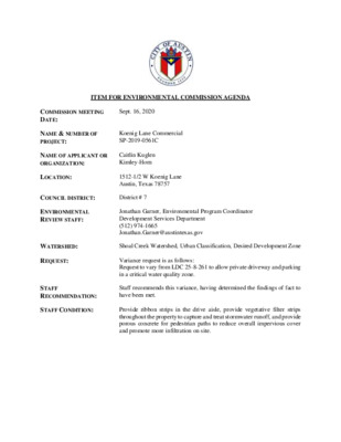
ITEM FOR ENVIRONMENTAL COMMISSION AGENDA COMMISSION MEETING DATE: Sept. 16, 2020 NAME & NUMBER OF PROJECT: Koenig Lane Commercial SP-2019-0561C NAME OF APPLICANT OR ORGANIZATION: Caitlin Kuglen Kimley-Horn LOCATION: 1512-1/2 W Koenig Lane Austin, Texas 78757 COUNCIL DISTRICT: District # 7 ENVIRONMENTAL REVIEW STAFF: WATERSHED: REQUEST: STAFF RECOMMENDATION: STAFF CONDITION: Jonathan Garner, Environmental Program Coordinator Development Services Department (512) 974-1665 Jonathan.Garner@austintexas.gov Shoal Creek Watershed, Urban Classification, Desired Development Zone Variance request is as follows: Request to vary from LDC 25-8-261 to allow private driveway and parking in a critical water quality zone. Staff recommends this variance, having determined the findings of fact to have been met. Provide ribbon strips in the drive aisle, provide vegetative filter strips throughout the property to capture and treat stormwater runoff, and provide porous concrete for pedestrian paths to reduce overall impervious cover and promote more infiltration on site. Staff Findings of Fact Variance to LDC XX-XX-XXX 1 Development Services Department Staff Recommendations Concerning Required Findings Project Name: Ordinance Standard: Watershed Protection Ordinance Variance Request: Koenig Lane Commercial (SP-2019-0561C) Request to vary LDC 25-8-261 to allow a private driveway and parking lot in a critical water quality zone. Include an explanation with each applicable finding of fact. A. Land Use Commission variance determinations from Chapter 25-8-41 of the City Code: 1. The requirement will deprive the applicant of a privilege available to owners of similarly situated property with approximately contemporaneous development subject to similar code requirements. Yes. LDC 25-8-261 will deprive the property owner of a privilege available to owners of other similarly situated property because the surrounding development (and zoning, LO-MU-NP) is all commercial businesses with similar sized lots and development. Additionally, due to the width and traffic volume along Koenig Drive, on-street parking is not an option. If the applicant is deprived of the privilege to develop this property in context with its current zoning and the surrounding uses, the property will remain vacant and unable to be developed or used in its current condition. 2. The variance: a) Is not necessitated by the scale, layout, construction method, or other design decision made by the applicant, unless the design decision provides greater overall environmental protection than is achievable without the variance; Yes. In order for the property to be developed under current zoning regulations and in context with the surrounding uses, the applicant is required to provide a means of vehicular ingress and egress, as well as parking on site. Due to the width and traffic volume along Koenig Drive, on-street parking is not an option. In order to achieve greater overall environmental protection, the applicant is providing a series of vegetated filter strips downgradient of the impervious cover as a means of providing some on-site water quality (page 15, variance packet). For a property this size, and the amount of proposed 2 impervious cover, on-site water quality is not a requirement. Additionally, the applicant is reducing the overall proposed impervious cover on the property by providing “ribbon strips” for the driveway and porous concrete for all pedestrian walkways (page 16, variance packet). These two methods result in a total proposed impervious cover amount of 55%, where as much as 70% is allowed. Is the minimum deviation from the code requirement necessary to allow a reasonable use of the property; Yes. The applicant is proposing less impervious cover than allowed (Urban watershed, limited only by zoning regulations-70%) and is providing some on-site water quality treatment that is otherwise not required due to property’s location, size of lot, and amount of proposed impervious cover. Does not create a significant probability of harmful environmental consequences. b) c) Yes. The applicant is providing vegetated filter strips throughout the property that will capture and treat some stormwater runoff before entering the City’s storm sewer infrastructure, as well as provide some infiltration benefits. 3. Development with the variance will result in water quality that is at least equal to the water quality achievable without the variance. Yes. Due to the property’s location, size of lot, and amount of proposed impervious cover, on-site water quality is not required. However, the applicant is providing some on-site water quality controls in the form of vegetated filter strips in order to treat and infiltrate some stormwater runoff on site. Neither a rain garden nor rainwater harvesting are feasible for the project since there is neither an accessible storm drain nor adequate roof drains with an irrigation system or a large enough area for a level spreader. Therefore, the vegetated filter strips method of providing on-site water quality control exceeds the water quality requirement that would be achievable without the variance. B. The Land Use Commission may grant a variance from a requirement of Section 25-8-422 (Water Supply Suburban Water Quality Transition Zone), Section 25-8-452 (Water Supply Rural Water Quality Transition Zone), Section 25-8-482 (Barton Springs Zone Water Quality Transition Zone), Section 25-8-368 (Restrictions on Development Impacting Lake Austin, Lady Bird Lake, and Lake Walter E. Long), or Article 7, Division 1 ( Critical Water Quality Zone Restrictions ), after determining that:: The criteria for granting a variance in Subsection (A) are met; Yes. All criteria in Subsection (A) are met. 1. 3 2. The requirement for which a variance is requested prevents a reasonable, economic use of the entire property; Yes. The proposed development is consistent with the applicable zoning and is contemporaneous with the surrounding properties. The lot has existed in its current configuration for many years. The property is entirely within the CWQZ; expanding the lot to extend beyond the CWQZ is not possible. This property was rezoned from SF to LO-MU-NP in 2004 [Ord. No. 040513-33A]. Based on the location of the property (fronting Koenig Lane), continued SF use is unlikely. In addition, based on the amount of existing impervious cover on the property (33%), and that proposed (55%), neither the redevelopment exception in LDC 25-8-26 nor the administrative variance option in LDC 25-8-42 are feasible. 3. The variance is the minimum deviation from the code requirement necessary to allow a reasonable, economic use of the entire property. Yes. The applicant proposes an impervious cover amount well below the maximum allowance and on-site water quality treatment that exceeds the minimum requirement of Code. Therefore, this minimum deviation from Code is necessary to allow a reasonable, economic use of the entire property. Staff Determination: Staff determines that the findings of fact have / have not been met. Staff recommends the following condition: Environmental Reviewer (DSD) _____________________________ Jonathan Garner Date: 9/8/2020 Environmental Policy Program Manager (DSD) _____________________________ Mike McDougal Date: 9/8/2020 Environmental Officer (WPD) _____________________________ Chris Herrington Date: 9/9/2020 4 Application Form Variance to LDC XX-XX-XXX 5 ENVIRONMENTAL BOARD VARIANCE APPLICATION TEMPLATE Insert Applicant Variance Request Letter here. February 28, 2013 PROJECT DESCRIPTION Applicant Contact Information Variance Case Information Name of Applicant Street Address City State ZIP Code Work Phone E-Mail Address Case Name Case Number Address or Location Environmental Reviewer Name Applicable Ordinance Watershed Name Watershed Classification ☐Urban ☐ Suburban ☐Water Supply Suburban ☐Water Supply Rural ☐ Barton Springs Zone City of Austin | Environmental Board Variance Application Guide 1 6 February 28, 2013 Edwards Aquifer Recharge Zone Edwards Aquifer Contributing Zone Distance to Nearest Classified Waterway Water and Waste Water service to be provided by Request Impervious cover square footage: acreage: percentage: Provide general description of the property (slope range, elevation range, summary of vegetation / trees, summary of the geology, CWQZ, WQTZ, CEFs, floodplain, heritage trees, any other notable or outstanding characteristics of the property) Clearly indicate in what way the proposed project ☐ Barton Springs Segment ☐ Northern Edwards Segment ☐ Not in Edwards Aquifer Zones ☐ Yes ☐ No The variance request is as follows (Cite code references: Existing ________ ________ ________ Proposed _________ _________ _________ City of Austin | Environmental Board Variance Application Guide 2 7 February 28, 2013 does not comply with current Code (include maps and exhibits) FINDINGS OF FACT Project: Ordinance: As required in LDC Section 25‐8‐41, in order to grant a variance the Land Use Commission must make the following findings of fact: Include an explanation with each applicable finding of fact. A. Land Use Commission variance determinations from Chapter 25‐8‐41 of the City Code: 1. The requirement will deprive the applicant of a privilege or the safety of property given to owners of other similarly situated property with approximately contemporaneous development. Yes/No [summary of justification for determination] 2. The variance: a) Is not based on a condition caused by the method chosen by the applicant to develop the property, unless the development method provides greater overall environmental protection than is achievable without the variance; Yes/No [summary of basis for determination] b) Is the minimum change necessary to avoid the deprivation of a privilege given to other property owners and to allow a reasonable use of the property; Yes/No [summary of basis for determination] c) Does not create a significant probability of harmful environmental consequences; and City of Austin | Environmental Board Variance Application Guide 3 8 February 28, 2013 Yes/No [summary of basis for determination] 3. Development with the variance will result in water quality that is at least equal to the water quality achievable without the variance. Yes/No [summary of basis for determination] B. Additional Land Use Commission variance determinations for a requirement of Section 25‐8‐393 (Water Quality Transition Zone), Section 25‐8‐423 (Water Quality Transition Zone), Section 25‐8‐453 (Water Quality Transition Zone), or Article 7, Division 1 (Critical Water Quality Zone Restrictions): 1. The criteria for granting a variance in Section A are met; Yes/No [summary of basis for determination] 2. The requirement for which a variance is requested prevents a reasonable, economic use of the entire property; and Yes/No [summary of basis for determination] 3. The variance is the minimum change necessary to allow a reasonable, economic use of the entire property. Yes/No [summary of basis for determination] **Variance approval requires all above affirmative findings. City of Austin | Environmental Board Variance Application Guide 4 9 Applicant Exhibits Variance to LDC XX-XX-XXX 10 NORTH SITE LOCATION MAP 13200 N. IH-35 SVRD. SB Austin, TX 78753 11 National Flood Hazard Layer FIRMette 30°20'10.41"N W " 9 0 . 0 2 4 4 ° 7 9 ' SEE FIS REPORT FOR DETAILED LEGEND AND INDEX MAP FOR FIRM PANEL LAYOUT Legend SPECIAL FLOOD HAZARD AREAS OTHER AREAS OF FLOOD HAZARD Without Base Flood Elevation (BFE) Zone A, V, A99 With BFE or Depth Zone AE, AO, AH, VE, AR Regulatory Floodway 0.2% Annual Chance Flood Hazard, Areas of 1% annual chance flood with average depth less than one foot or with drainage areas of less than one square mile Zone X Future Conditions 1% Annual Chance Flood Hazard Zone X Area with Reduced Flood Risk due to Levee. See Notes. Zone X Area with Flood Risk due to Levee Zone D NO SCREEN Area of Minimal Flood Hazard Zone X Effective LOMRs OTHER AREAS Area of Undetermined Flood Hazard Zone D GENERAL STRUCTURES Channel, Culvert, or Storm Sewer Levee, Dike, or Floodwall 20.2 Cross Sections with 1% Annual Chance 17.5 Water Surface Elevation B 8 Coastal Transect Base Flood Elevation Line (BFE) Limit of Study Jurisdiction Boundary Coastal Transect Baseline Profile Baseline Hydrographic Feature Digital Data Available No Digital Data Available Ü The pin displayed on the map is an approximate point selected by the user and does not represent an authoritative property location. OTHER FEATURES MAP PANELS Unmapped This map complies with FEMA's standards for the use of digital flood maps if it is not void as described below. The basemap shown complies with FEMA's basemap accuracy standards The flood hazard information is derived directly from the authoritative NFHL web services provided by FEMA. This map was exported on 10/24/2018 at 4:06:50 PM and does not reflect changes or amendments subsequent to this date and time. The NFHL and effective information may change or become superseded by new data over time. This map image is void if the one or more of the following map elements do not appear: basemap imagery, flood zone labels, legend, scale bar, map creation date, community identifiers, FIRM panel number, and FIRM effective date. Map images for unmapped and unmodernized areas cannot be used for regulatory purposes. ' 9 7 ° 4 3 4 2 . 6 3 " W 30°19'39.36"N 0 250 500 1,000 1,500 Feet 2,000 1:6,000 USGS The National Map: Orthoimagery. Data refreshed October 2017. 12 . C N I , I I - S E T A C O S S A D N A N R O H Y E L M K O T Y T L B A L T U O H T W E B L L A H S I I I I . C N I , I I I I I - S E T A C O S S A D N A N R O H Y E L M K Y B N O T A T P A D A D N A N O T A Z R O H T U A N E T T R W T U O H T W T N E M U C O D S H T N O E C N A L E R R E P O R P M I I I I I D N A F O E S U E R . D E R A P E R P S A W T I I I H C H W R O F T N E L C D N A E S O P R U P C F C E P S E H T R O F Y L N O D E D N E T N I I I S I , I E C V R E S F O T N E M U R T S N I N A S A , I I N E R E H D E T N E S E R P S N G S E D D N A S T P E C N O C E H T H T W R E H T E G O T I , T N E M U C O D S H T I . I \ \ I G W D T B H X E Z Q W C S T E E H S N A L P S T B H X E G W D N L G N E O K W 2 1 5 1 I \ I \ I - 0 0 6 1 6 2 9 6 0 \ I I L V C _ U A S \ : K M A 6 5 : 9 9 1 0 2 / 4 / 9 E C Y R B , R R A B M A 3 2 : 9 9 1 0 2 / 4 / 9 Y B D E T T O L P E M A N G W D D E V A S T S A L NORTH GRAPHIC SCALE IN FEET GRAPHIC SCALE IN FEET 0 0 25 25 50 50 50 50 100 100 WHEN PLOTTED AT 24" x 36" WHEN PLOTTED AT 24" x 36" Y B E T A D I S N O S V E R I . o N I I I 8 2 9 - F M R F G N R E E N G N E D E R E T S G E R S A X E T I . C N I , I S E T A C O S S A D N A N R O H Y E L M K 7 1 0 2 - I © 0 0 3 E T U S I , 1 E C A R R E T , A N U T R O F A V 0 0 6 2 I 6 4 7 8 7 S A X E T , I N T S U A 7 3 2 2 - 6 4 6 ) 2 1 5 ( : E N O H P FOR REVIEW ONLY Engineer P.E. No. ANDREW S. EVANS 90927 Date AUG. 2018 . o N T C E J O R P 0 0 6 1 6 2 9 6 0 8 1 0 2 R E B M E V O N : E T A D N W O H S S A : E L A C S E S A : Y B D E N G S E D I B A B : Y B N W A R D E S A : Y B D E K C E H C R E T A W L A C T R C I I I I T B H X E E N O Z Y T L A U Q I E N A L G N E O K I I L A C R E M M O C I E N A L G N E O K T S E W 2 1 5 1 6 5 7 8 7 X T , I N T S U A SHEET NUMBER 01 OF 15 SP-2018-0547C NOTES: CREEK CENTERLINES DRAWN FROM COA GIS SHAPEFILES. DRY CREEK (HANCOCK BRANCH) CLASSIFIED AS AN INTERMEDIATE WATERWAY PER SECION 30-5-91 OF AUSTIN CODE. SITE PLAN APPROVAL SHEET ______OF______ 01 15 FILE NUMBER__________________APPLICATION DATE_______________ SPC-2018-0547C 11/13/2018 APPROVED BY COMMISSION ON_______________UNDER SECTION_______ OF 112 CHAPTER__________OF THE CITY OF AUSTIN CODE. 25-5 EXPIRATION DATE (25-5-81,LDC)_______________CASE MANAGER_____________ Clarissa E. Davis PROJECT EXPIRATION DATE (ORD.#970905-A)__________DWPZ______DDZ______ __________________________________________________________________________ DIRECTOR, DEVELOPMENT SERVICES DEPARTMENT RELEASED FOR GENERAL COMPLIANCE:_____________ZONING_____________ LO-MU-NP Rev. 1____________________________Correction 1_____________________________ Rev. 2____________________________Correction 2_____________________________ Rev. 3____________________________Correction 3_____________________________ Final plat must be recorded by the Project Expiration Date, if applicable. Subsequent Site Plans which do not comply with the Code current at the time of filing, and all required Building Permits and/or a notice of construction (if a building permit is not required), must also be approved prior to the Project Expiration Date. WARNING CONTRACTOR IS TO VERIFY PRESENCE AND EXACT LOCATION OF ALL UTILITIES PRIOR TO CONSTRUCTION. 13 N O R T H 14 N O R T H 15 . C N I , I I - S E T A C O S S A D N A N R O H Y E L M K O T Y T L B A L T U O H T W E B L L A H S I I I I . C N I , I I I I I - S E T A C O S S A D N A N R O H Y E L M K Y B N O T A T P A D A D N A N O T A Z R O H T U A N E T T R W T U O H T W T N E M U C O D S H T N O E C N A L E R R E P O R P M I I I I I D N A F O E S U E R . D E R A P E R P S A W T I I I H C H W R O F T N E L C D N A E S O P R U P C F C E P S E H T R O F Y L N O D E D N E T N I I I S I , I E C V R E S F O T N E M U R T S N I N A S A , I I N E R E H D E T N E S E R P S N G S E D D N A S T P E C N O C E H T H T W R E H T E G O T I , T N E M U C O D S H T I I . G W D N A L P G N V A P 1 1 \ S T E E H S N A L P G W D N L G N E O K W 2 1 5 1 \ I \ - 0 0 6 1 6 2 9 6 0 \ I I L V C _ U A S \ : K M P 4 3 : 5 0 2 0 2 / 1 / I 9 N L T A C I , N E L G U K M P 3 3 : 5 0 2 0 2 / 1 / 9 Y B D E T T O L P E M A N G W D D E V A S T S A L H T R O N GRAPHIC SCALE IN FEET 0 5 10 10 20 WHEN PLOTTED AT 24" x 36" LEGEND PROPERTY LINE ADJACENT PROPERTY LINE EASEMENT LINE PROPOSED FIRE LANE PROPOSED SIDEWALK PROPOSED MEDIUM DUTY CONCRETE PAVEMENT PER DETAIL ON SHEET 13. PROPOSED HEAVY DUTY CONCRETE PAVEMENT PER DETAIL ON SHEET 13. 1. 3. SPECIFICATIONS AND RECOMMENDATIONS ARE BASED ON THE GEOTECHNICAL REPORT REPORT NO. 3014-1019 PREPARED BY FUGRO CONSULTANTS, INC, DATED JANUARY 09, 2015. 9. 2. PORTLAND CEMENT CONCRETE SHALL HAVE A MINIMUM 28-DAY COMPRESSIVE STRENGTH OF 4,000 PSI AND BE REINFORCED WITH A MINIMUM OF NO. 4 BARS ON 18-INCH CENTERS, EACH WAY. SCARIFY AND COMPACT THE EXPOSED SOIL SUBGRADE TO AT LEAST 95% OF THE MAXIMUM DRY DENSITY DETERMINED OF TRANSPORTATION (TXDOT) TEST METHOD TEX-113-E. MAINTAIN WATER CONTENTS DURING CONSTRUCTION FROM +1 TO +3% ABOVE THE OPTIMUM WATER CONTENT. DEPARTMENT TEXAS USING 4. PROOF ROLL THE PREPARED SUBGRADE IN ACCORDANCE WITH ITEM 236S OF THE CURRENT CITY OF AUSTIN STANDARD SPECIFICATIONS. PROOF ROLLING OPERATION A BE REPRESENTATIVE OF THE GEOTECHNICAL ENGINEER. ANY BE OVER-EXCAVATED AND REPLACED WITH PROCESSED ON SITE MATERIAL COMPACTED AS STATED ABOVE. SOFT OR WEAK SUBGRADE OBSERVED SHOULD SHOULD THE BY 5. PLACE THE RECOMMENDED THICKNESS OF CRUSHED LIMESTONE FLEXIBLE BASE THAT CONFORMS TO THE CURRENT CITY OF AUSTIN STANDARD SPECIFICATIONS ITEM 210S. COMPACT THE FLEXIBLE BASE TO 100% OF THE MAXIMUM DRY DENSITY DETERMINED USING TXDOT TEST METHOD TEX-113-E. HOLD WATER CONTENTS TO WITHIN ±2% OF THE OPTIMUM, AND MAINTAIN COMPACTED LIFT THICKNESSES TO 6 INCHES OR LESS. 6. CONSTRUCTION OF HOT MIX ASPHALTIC CONCRETE SHOULD BE IN CONFORMANCE WITH ITEM 340 OF THE CURRENT CITY OF AUSTIN STANDARD SPECIFICATIONS. 7. CONSTRUCTION OF REINFORCED PORTLAND CEMENT CONCRETE PAVEMENT SHOULD BE IN CONFORMANCE WITH ITEM 360 OF THE CURRENT CITY OF AUSTIN STANDARD SPECIFICATIONS. 8. SUPPORT CONCRETE REINFORCEMENT STEEL WITH CHAIRS OR PRECAST CONCRETE BLOCKS ABOUT 1 INCH BELOW THE BOTTOM OF THE PLANNED CONTRACTION JOINTS. SPACE TRANSVERSE AND LONGITUDINAL CONCRETE CONTRACTION JOINTS (INDUCED CRACKS) AT INTERVALS NOT EXCEEDING 15 FEET. THE CONTRACTION JOINT PATTERN SHOULD DIVIDE THE PAVEMENT INTO PANELS THAT ARE APPROXIMATELY SQUARE, WITH THE LENGTH OF ANY PANEL NO MORE THAN 20 PERCENT GREATER THAN WIDTH. DEPTH OF JOINTS MUST BE AT LEAST ONE-QUARTER OF THE SLAB THICKNESS. THE JOINTS MUST BE SAWCUT AS SOON AS THE CONCRETE HAS HARDENED AND WILL NOT TEAR OR RAVEL WHEN CUT, AND NOT MORE THAN 16 HOURS AFTER PLACEMENT. FREQUENT DEPTH CHECKS OF THE JOINTS BY AN INDEPENDENT ARE RECOMMENDED DURING THE SAW CUTTING OPERATION. CONTROL QUALITY AGENCY 10. EXPANSION JOINTS SHOULD BE USED WHEREVER THE PAVEMENT WILL ABUT A STRUCTURAL ELEMENT SUBJECT TO DIFFERENT MAGNITUDE OF MOVEMENT, E.G., LIGHT POLES, PAVEMENT, STAIRWAYS, ENTRYWAY PIERS, BUILDING WALLS, OR MANHOLES. UNLESS OTHERWISE NOTED. RETAINING WALLS, EXISTING 11. EXPANSION JOINTS SHALL BE SPACED NO GREATER THAN 75' AND SEALED WITH APPROPRIATE SEALANT TO MINIMIZE MOISTURE INFILTRATION INTO THE SUBGRADE SOILS AND RESULTANT CONCRETE DETERIORATION AT THE JOINTS. 12. EXPANSION JOINTS TO RUN CONTINUOUSLY THROUGH CURBS. 13. PROVIDE LOAD TRANSFER AT THE INTERFACE BETWEEN AREAS OF CONCRETE PLACED AT DIFFERENT TIMES USING TIED AND KEYED CONSTRUCTION JOINTS. PLACE CONSTRUCTION JOINTS AT PLANNED CONTRACTION JOINT LOCATIONS. (SEE ACI MANUAL OF CONCRETE PRACTICE, PART 2, FOR FURTHER GUIDANCE.) 14. ALL JOINTS SHOULD BE SEALED IN ACCORDANCE WITH ITEM 360 OF THE CURRENT CITY OF AUSTIN STANDARD SPECIFICATIONS. 15. STAGE PAVEMENT CONSTRUCTION THAT CONSTRUCTION TRAFFIC, INCLUDING CONCRETE TRUCKS, DO NOT TRAVEL ON NEWLY PLACED CONCRETE PAVEMENT UNTIL THE CONCRETE ACHIEVES AT LEAST 75 PERCENT OF THE DESIGN STRENGTH, USUALLY 7 DAYS. SUCH Y B E T A D I S N O S V E R I . o N I I I 8 2 9 - F M R F G N R E E N G N E D E R E T S G E R S A X E T I . C N I , I S E T A C O S S A D N A N R O H Y E L M K 7 1 0 2 - I © 0 0 3 E T U S I , 1 E C A R R E T , A N U T R O F A V 0 0 6 2 I 6 4 7 8 7 S A X E T , I N T S U A 7 3 2 2 - 6 4 6 ) 2 1 5 ( : E N O H P . o N T C E J O R P 0 0 6 1 6 2 9 6 0 8 1 0 2 R E B M E V O N : E T A D N W O H S S A : E L A C S B A B : Y B D E N G S E D I B A B : Y B N W A R D E S A : Y B D E K C E H C N A L P G N V A P I E N A L G N E O K I I L A C R E M M O C I E N A L G N E O K T S E W 2 1 5 1 6 5 7 8 7 X T , I N T S U A SHEET NUMBER 10 OF 14 SP-2019-0561C SITE PLAN APPROVAL SHEET ______OF______ 14 10 FILE NUMBER__________________APPLICATION DATE_______________ SPC-2018-0547C 11/13/2018 APPROVED BY COMMISSION ON_______________UNDER SECTION_______ OF 112 CHAPTER__________OF THE CITY OF AUSTIN CODE. 25-5 EXPIRATION DATE (25-5-81,LDC)_______________CASE MANAGER_____________ Clarissa E. Davis PROJECT EXPIRATION DATE (ORD.#970905-A)__________DWPZ______DDZ______ __________________________________________________________________________ DIRECTOR, DEVELOPMENT SERVICES DEPARTMENT RELEASED FOR GENERAL COMPLIANCE:_____________ZONING_____________ LO-MU-NP Rev. 1____________________________Correction 1_____________________________ Rev. 2____________________________Correction 2_____________________________ Rev. 3____________________________Correction 3_____________________________ Final plat must be recorded by the Project Expiration Date, if applicable. Subsequent Site Plans which do not comply with the Code current at the time of filing, and all required Building Permits and/or a notice of construction (if a building permit is not required), must also be approved prior to the Project Expiration Date. WARNING CONTRACTOR IS TO VERIFY PRESENCE AND EXACT LOCATION OF ALL UTILITIES PRIOR TO CONSTRUCTION. 16 . C N I , I I - S E T A C O S S A D N A N R O H Y E L M K O T Y T I L I B A I L T U O H T W E B L L A H S I . C N I , I I I I I - S E T A C O S S A D N A N R O H Y E L M K Y B N O T A T P A D A D N A N O T A Z R O H T U A N E T T R W T U O H T W T N E M U C O D S H T N O E C N A L E R R E P O R P M I I I I I D N A F O E S U E R . D E R A P E R P S A W T I I I H C H W R O F T N E L C D N A E S O P R U P C F C E P S E H T R O F Y L N O D E D N E T N I I I S I , I E C V R E S F O T N E M U R T S N I N A S A , I I N E R E H D E T N E S E R P S N G S E D D N A S T P E C N O C E H T H T W R E H T E G O T I , T N E M U C O D S H T I . I \ G W D N A L P G N V A P 1 1 S T E E H S N A L P G W D N L G N E O K W 2 1 5 1 \ I \ - 0 0 6 1 6 2 9 6 0 L V C _ U A S I \ I \ : K M A 5 1 : 0 1 0 2 0 2 / / 0 1 1 E C Y R B , R R A B : M A 2 1 0 1 0 2 0 2 / 0 1 / 1 Y B D E T T O L P D E V A S T S A L E M A N G W D RAVI SRINIVASAN DOC. NO.2016054512 ZONING: SF-3-NP USE: SINGLE FAMILY LOT 15 ZONING: SF-3-NP USE: SINGLE FAMILY LOT 13 ZONING: SF-3-NP USE: SINGLE FAMILY MICHAEL A. REIFF ET. AL. DOC. NO.2002087997 S 60°18'00" E 59.28' . . E U P . ' 0 1 LOT 21 LOT 22 6 0 ° ' LOT 23 (T 9.0' P.) Y R 3 . 0 ' ' 3 3 . 0 3 1 ' E " 0 0 5 4 ° 9 2 N ' 0 . 1 3 11.5' ' 5 . 8 1 ) . P Y T ( ' 0 . 6 1 ' 5 . 2 EXISTING ONE-STORY BUILDING 924 SF R 8 . 0 ' 5.5' 5.0' ' 8 . 6 4 ' 3 . 7 4 ' 5 . 1 2 5.0' 10.0' ' 6 6 . 0 3 1 W ' " 0 0 5 4 ° 9 2 S 6 . 0 ' R ' 9 . 2 4 10.7' ' . 7 2 1 14.1' EVELYN HEREFORD TRUST DOC. NO.2008176150 ZONING: LO-MU-NP USE: RETAIL ' 4 . 5 6 IMRAN ISMAIL AND TAUQEER ABDUL QADIR DOC. NO.2016141818 ZONING: LO-MU-NP USE: SINGLE FAMILY N 59°59'00" W 59.28' S 59°46'36" E 60.33' WEST KOENIG LANE (R.O.W. VARIES) TIE INTO EXISTING DRIVEWAYS H T R O N GRAPHIC SCALE IN FEET 0 5 10 10 20 WHEN PLOTTED AT 24" x 36" LEGEND PROPERTY LINE ADJACENT PROPERTY LINE EASEMENT LINE PROPOSED FIRE LANE PROPOSED SIDEWALK PROPOSED MEDIUM DUTY CONCRETE PAVEMENT PER DETAIL ON SHEET 13. PROPOSED HEAVY DUTY CONCRETE PAVEMENT PER DETAIL ON SHEET 13. PAVING NOTES 1. SPECIFICATIONS AND RECOMMENDATIONS ARE BASED ON THE GEOTECHNICAL REPORT REPORT NO. 3014-1019 PREPARED BY FUGRO CONSULTANTS, INC, DATED JANUARY 09, 2015. 2. PORTLAND CEMENT CONCRETE SHALL HAVE A MINIMUM 28-DAY COMPRESSIVE STRENGTH OF 4,000 PSI AND BE REINFORCED WITH A MINIMUM OF NO. 4 BARS ON 18-INCH CENTERS, EACH WAY. 3. SCARIFY AND COMPACT THE EXPOSED SOIL SUBGRADE TO AT LEAST 95% OF THE MAXIMUM DRY DENSITY DETERMINED OF TRANSPORTATION (TXDOT) TEST METHOD TEX-113-E. MAINTAIN WATER CONTENTS DURING CONSTRUCTION FROM +1 TO +3% ABOVE THE OPTIMUM WATER CONTENT. DEPARTMENT TEXAS USING 4. PROOF ROLL THE PREPARED SUBGRADE IN ACCORDANCE WITH ITEM 236S OF THE CURRENT CITY OF AUSTIN STANDARD SPECIFICATIONS. THE PROOF ROLLING OPERATION A REPRESENTATIVE OF THE GEOTECHNICAL ENGINEER. ANY SOFT OR WEAK SUBGRADE SHOULD BE OVER-EXCAVATED AND REPLACED WITH PROCESSED ON SITE MATERIAL COMPACTED AS STATED ABOVE. OBSERVED SHOULD BY BE 5. PLACE THE RECOMMENDED THICKNESS OF CRUSHED LIMESTONE FLEXIBLE BASE THAT CONFORMS TO THE CURRENT CITY OF AUSTIN STANDARD SPECIFICATIONS ITEM 210S. COMPACT THE FLEXIBLE BASE TO 100% OF THE MAXIMUM DRY DENSITY DETERMINED USING TXDOT TEST METHOD TEX-113-E. HOLD WATER CONTENTS TO WITHIN ±2% OF THE OPTIMUM, AND MAINTAIN COMPACTED LIFT THICKNESSES TO 6 INCHES OR LESS. 6. CONSTRUCTION OF HOT MIX ASPHALTIC CONCRETE SHOULD BE IN CONFORMANCE WITH ITEM 340 OF THE CURRENT CITY OF AUSTIN STANDARD SPECIFICATIONS. 7. CONSTRUCTION OF REINFORCED PORTLAND CEMENT CONCRETE PAVEMENT SHOULD BE IN CONFORMANCE WITH ITEM 360 OF THE CURRENT CITY OF AUSTIN STANDARD SPECIFICATIONS. 8. SUPPORT CONCRETE REINFORCEMENT STEEL WITH CHAIRS OR PRECAST CONCRETE BLOCKS ABOUT 1 INCH BELOW THE BOTTOM OF THE PLANNED CONTRACTION JOINTS. 9. SPACE TRANSVERSE AND LONGITUDINAL CONCRETE CONTRACTION JOINTS (INDUCED CRACKS) AT INTERVALS NOT EXCEEDING 15 FEET. THE CONTRACTION JOINT PATTERN SHOULD DIVIDE THE PAVEMENT INTO PANELS THAT ARE APPROXIMATELY SQUARE, WITH THE LENGTH OF ANY PANEL NO MORE THAN 20 PERCENT GREATER THAN WIDTH. DEPTH OF JOINTS MUST BE AT LEAST ONE-QUARTER OF THE SLAB THICKNESS. THE JOINTS MUST BE SAWCUT AS SOON AS THE CONCRETE HAS HARDENED AND WILL NOT TEAR OR RAVEL WHEN CUT, AND NOT MORE THAN 16 HOURS AFTER PLACEMENT. FREQUENT DEPTH CHECKS OF THE JOINTS BY AN INDEPENDENT QUALITY CONTROL ARE RECOMMENDED DURING THE SAW CUTTING OPERATION. AGENCY 10. EXPANSION JOINTS SHOULD BE USED WHEREVER THE PAVEMENT WILL ABUT A STRUCTURAL ELEMENT SUBJECT TO DIFFERENT MAGNITUDE OF MOVEMENT, E.G., LIGHT POLES, RETAINING WALLS, EXISTING PAVEMENT, STAIRWAYS, ENTRYWAY PIERS, BUILDING WALLS, OR MANHOLES. UNLESS OTHERWISE NOTED. 11. EXPANSION JOINTS SHALL BE SPACED NO GREATER THAN 75' AND SEALED WITH APPROPRIATE SEALANT TO MINIMIZE MOISTURE INFILTRATION INTO THE SUBGRADE SOILS AND RESULTANT CONCRETE DETERIORATION AT THE JOINTS. 12. EXPANSION JOINTS TO RUN CONTINUOUSLY THROUGH CURBS. 13. PROVIDE LOAD TRANSFER AT THE INTERFACE BETWEEN AREAS OF CONCRETE PLACED AT DIFFERENT TIMES USING TIED AND KEYED CONSTRUCTION JOINTS. PLACE CONSTRUCTION JOINTS AT PLANNED CONTRACTION JOINT LOCATIONS. (SEE ACI MANUAL OF CONCRETE PRACTICE, PART 2, FOR FURTHER GUIDANCE.) 14. ALL JOINTS SHOULD BE SEALED IN ACCORDANCE WITH ITEM 360 OF THE CURRENT CITY OF AUSTIN STANDARD SPECIFICATIONS. 15. STAGE PAVEMENT CONSTRUCTION THAT CONSTRUCTION TRAFFIC, INCLUDING CONCRETE TRUCKS, DO NOT TRAVEL ON NEWLY PLACED CONCRETE PAVEMENT UNTIL THE CONCRETE ACHIEVES AT LEAST 75 PERCENT OF THE DESIGN STRENGTH, USUALLY 7 DAYS. SUCH Y B E T A D I S N O S V E R I . o N I I I 8 2 9 - F M R F G N R E E N G N E D E R E T S G E R S A X E T I . C N I , I S E T A C O S S A D N A N R O H Y E L M K 7 1 0 2 - I © 0 0 3 E T U S I , 1 E C A R R E T , A N U T R O F A V 0 0 6 2 I 6 4 7 8 7 S A X E T , I N T S U A 7 3 2 2 - 6 4 6 ) 2 1 5 ( : E N O H P . o N T C E J O R P 0 0 6 1 6 2 9 6 0 8 1 0 2 R E B M E V O N : E T A D N W O H S S A : E L A C S B A B : Y B D E N G S E D I B A B : Y B N W A R D E S A : Y B D E K C E H C N A L P G N V A P I E N A L G N E O K I I L A C R E M M O C I E N A L G N E O K T S E W 2 1 5 1 6 5 7 8 7 X T , I N T S U A SHEET NUMBER 10 OF 14 SP-2018-0547C SITE PLAN APPROVAL SHEET ______OF______ 14 10 FILE NUMBER__________________APPLICATION DATE_______________ SPC-2018-0547C 11/13/2018 APPROVED BY COMMISSION ON_______________UNDER SECTION_______ OF 112 CHAPTER__________OF THE CITY OF AUSTIN CODE. 25-5 EXPIRATION DATE (25-5-81,LDC)_______________CASE MANAGER_____________ Clarissa E. Davis PROJECT EXPIRATION DATE (ORD.#970905-A)__________DWPZ______DDZ______ __________________________________________________________________________ DIRECTOR, DEVELOPMENT SERVICES DEPARTMENT RELEASED FOR GENERAL COMPLIANCE:_____________ZONING_____________ LO-MU-NP Rev. 1____________________________Correction 1_____________________________ Rev. 2____________________________Correction 2_____________________________ Rev. 3____________________________Correction 3_____________________________ WARNING CONTRACTOR IS TO VERIFY PRESENCE AND EXACT LOCATION OF ALL UTILITIES PRIOR TO CONSTRUCTION. Know what'sbelow. Call before you dig. Final plat must be recorded by the Project Expiration Date, if applicable. Subsequent Site Plans which do not comply with the Code current at the time of filing, and all required Building Permits and/or a notice of construction (if a building permit is not required), must also be approved prior to the Project Expiration Date. 17