20200715-003c: 3002 Scenic Dr SP-2020-1025D variance packet — original pdf
Backup
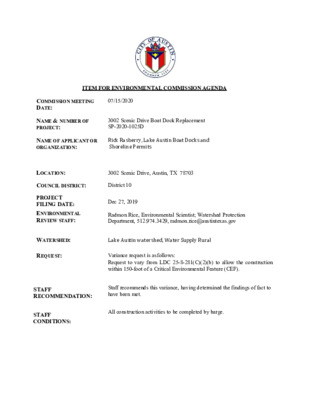
ITEM FOR ENVIRONMENTAL COMMISSION AGENDA COMMISSION MEETING DATE: 07/15/2020 NAME & NUMBER OF PROJECT: 3002 Scenic Drive Boat Dock Replacement SP-2020-1025D NAME OF APPLICANT OR ORGANIZATION: Rick Rasberry, Lake Austin Boat Docks and Shoreline Permits LOCATION: 3002 Scenic Drive, Austin, TX 78703 COUNCIL DISTRICT: District 10 PROJECT FILING DATE: ENVIRONMENTAL REVIEW STAFF: WATERSHED: REQUEST: Dec 27, 2019 Radmon Rice, Environmental Scientist; Watershed Protection Department, 512.974.3429, radmon.rice@austintexas.gov Lake Austin watershed, Water Supply Rural Variance request is as follows: Request to vary from LDC 25-8-281(C)(2)(b) to allow the construction within 150-foot of a Critical Environmental Feature (CEF). STAFF RECOMMENDATION: Staff recommends this variance, having determined the findings of fact to have been met. STAFF CONDITIONS: All construction activities to be completed by barge. Staff Findings of Fact Watershed Protection Department Staff Recommendations Concerning Required Findings Project Name & Case Number: 3002 Scenic Dr Boat Dock Replacement SP-2020-1025D Ordinance Standard: Watershed Protection Ordinance Variance Request: LDC 25-8-281(C)(2)(b) - To allow construction within 150 feet of a Rimrock and Seep Critical Environmental Features (CEF) . Include an explanation with each applicable finding of fact. A. Land Use Commission variance determinations from Chapter 25-8-41 of the City Code: 1. The requirement will deprive the applicant of a privilege available to owners of similarly situated property with approximately contemporaneous development subject to similar code requirements. Yes. A variance from 25-8-281(C)(2)(b) allowing for construction of a boat dock, shoreline access, and stabilization, has been granted for similarly situated properties with approximately contemporaneous development subject to similar code. 2. The variance: a) Is not necessitated by the scale, layout, construction method, or other design decision made by the applicant, unless the design decision provides greater overall environmental protection than is achievable without the variance; Yes. An existing noncompliant boat dock is proposed to be brought into compliance. No disturbance of the rimrock or seep CEF is proposed, all proposed construction activities are to occur downgradient of the rimrock/seep CEFs, and construction is to occur from the lakeside by barge. The proposed construction to be performed from a barge provides greater overall environmental protection. Additionally, the applicant is providing wetland plantings along the shoreline that will reduce shoreline erosion and sediment-laden surface runoff from discharging into the lake. b) Is the minimum deviation from the code requirement necessary to allow a reasonable use of the property; Yes. The variance is the minimum deviation from the code requirement to allow for a reasonable use of the property. The code requires a 150-foot critical environmental feature buffer. This buffer is not being reduced. The scope of the variance is limited to allowing construction activities to occur within a critical environmental feature buffer only for the proposed boat dock replacement. c) Does not create a significant probability of harmful environmental consequences. Yes. The variance does not create significant harmful environmental consequences. The construction of the boat dock from barge will not disturb the rimrock or seep critical environmental feature. The applicant is providing wetland plantings along the shoreline that will reduce shoreline erosion and sediment-laden surface runoff from discharging into the lake. 3. Development with the variance will result in water quality that is at least equal to the water quality achievable without the variance. Yes, the variance will result in water quality that is at least equal to the water quality achievable without the variance. The construction activities will not disturb the rimrock or seep critical environmental features. The proposed wetland planting along the shoreline will reduce soil erosion along the shoreline and provide filtration of sediment-laden runoff from upgradient areas, thereby providing water quality that is at least equal to or greater than the water quality achievable without the variance. Staff Recommendation: Staff recommends the variance as the Findings of Fact have been met, with the staff recommended condition that all construction be completed by barge. B. The Land Use Commission may grant a variance from a requirement of Section 25-8- 422 (Water Supply Suburban Water Quality Transition Zone), Section 25-8-452 (Water Supply Rural Water Quality Transition Zone), Section 25-8-482 (Barton Springs Zone Water Quality Transition Zone), Section 25-8-368 (Restrictions on Development Impacting Lake Austin, Lady Bird Lake, and Lake Walter E. Long), or Article 7, Division 1 ( Critical Water Quality Zone Restrictions ), after determining that: 1. 2. 3. The criteria for granting a variance in Subsection (A) are met; Yes / No N/A Yes / No N/A The requirement for which a variance is requested prevents a reasonable, economic use of the entire property; The variance is the minimum deviation from the code requirement necessary to allow a reasonable, economic use of the entire property. Yes / No N/A Staff Recommendation: N/A. Hydrogeologic Reviewer (WPD) ___________________________ Radmon Rice Date: 06-12-2020 Environmental Officer (WPD) _____________________________ Chris Herrington Date: 06-12-2020 Applicant Form and Findings of Fact May 26, 2020 ENVIRONMENTAL COMMISSION VARIANCE APPLICATION FORM PROJECT DESCRIPTION Applicant Contact Information Variance Case Information 3002 Scenic Dr Boat Dock Replacement Name of Applicant Street Address City State ZIP Code Work Phone E-Mail Address Case Name Case Number Address or Location Environmental Reviewer Name Environmental Resource Management Reviewer Name Applicable Ordinance Rick Rasberry (Agent for Meredith Dreiss) 2510 Cynthia Ct Leander, TX 78641 512-970-0371 rick@rickrasberry.com SP-2020-1025C 3002 Scenic Drive Pamela Abee-Taulli Radmon Rice Watershed Protection Ordinance Watershed Name Lake Austin Watershed Classification ☐Urban X Water Supply Rural ☐ Suburban ☐Water Supply Suburban ☐ Barton Springs Zone City of Austin | Environmental Commission Variance Application Guide 1 Edwards Aquifer Recharge Zone ☐ Barton Springs Segment ☐ Northern Edwards Segment X Not in Edwards Aquifer Zones ☐ Yes X No The proposed dock/access is on a classified waterway No water or wastewater service provided to boat dock To allow construction of a boat dock within a canyon rimrock/seep complex Critical Environmental Feature (CEF) buffer – Land Development Code Section 25-8-281(C)(2)(b) Existing 990 SF 0.02272 acre N/A Proposed 719 SF 0.01651 acre N/A The residential lot up gradient (above 492.8 msl) of the proposed dock includes slope ranging from 5% to greater than 35%, with topography ranging from 492.8 to 550.0 msl. An existing dock with pedestrian access rock steps have been developed on the property for several years. The proposed site plans delineate one (1) CEF on the residential property purported by COA. One rimrock/seep complex at about elevation 520-540ft (msl) demarcated on the proposed plans is up gradient of the proposed dock remodel. May 26, 2020 Edwards Aquifer Contributing Zone Distance to Nearest Classified Waterway Water and Waste Water service to be provided by Request Impervious cover square footage: acreage: percentage: Provide general description of the property (slope range, elevation range, summary of vegetation / trees, summary of the geology, CWQZ, WQTZ, CEFs, floodplain, heritage trees, any other notable or outstanding characteristics of the property) City of Austin | Environmental Commission Variance Application Guide 2 COA staff contend that the proposed residential boat dock replacement is prohibited from development in the CEF Buffer Zone. May 26, 2020 Clearly indicate in what way the proposed project does not comply with current Code (include maps and exhibits) FINDINGS OF FACT A. 1. 2. 3. 4. 5. 6. 7. As required in LDC Section 25-8-41, in order to grant a variance the Land Use Commission must make the following findings of fact: Include an explanation with each applicable finding of fact. Project: 3002 Scenic Dr Boat Dock Replacement Ordinance: Watershed Protection Land Use Commission variance determinations from Chapter 25-8-41 of the City Code: 1. The requirement will deprive the applicant of a privilege available to owners of similarly situated property with approximately contemporaneous development subject to similar code requirements. Yes, there are at least fifteen (15) similarly situated properties on Lake Austin that have received approval from the City to develop a boat dock within a CEF Buffer, examples as follows: 3307 Far View Drive (SP-2011-0279D) 3311 Far View Drive (SP-2011-0242D) 3319 Far View Drive (SP-2010-0015DS) 3337 Far View Drive (SP-2014-0135D) 3825 Westlake Drive (SP-2017-0032DS) 3811 Westlake Drive (SP-2016-0185DS) 3909 Westlake Drive (SP-2015-0232DS) City of Austin | Environmental Commission Variance Application Guide 3 May 26, 2020 8. 9. 3715 Westlake Drive (SP-2014-0182D) 2806 Scenic Drive (SP-2015-0202DS) 10. 70 Pascal Lane (SP-2014-0144D) 11. 2415 Big Horn Drive (SP-2014-0212DS) 12. 2908 Scenic Drive (SP-2013-0295DS) 13. 3213 Smoky Ridge (SP-2012-0366DS) 14. 5 Humboldt Lane (SP-2013-0133D) 15. 3919 Westlake Drive (SP-2018-0320DS) 2. The variance: a) Is not necessitated by the scale, layout, construction method, or other design decision made by the applicant, unless the design decision provides greater overall environmental protection than is achievable without the variance; b) c) Yes, the property owner is requesting to replace the nonconforming boat dock. No disturbance of the canyon rimrock CEF is proposed, providing greater overall protection for the rimrock with all proposed construction activities occurring downgradient of the rimrock CEF, and from the lakeside by barge. The proposed construction to be performed from a barge provides greater overall environmental protection since there would be no construction on the slopes. Is the minimum deviation from the code requirement necessary to allow a reasonable use of the property; Yes, there is an existing boat dock and this application for the replacement of it. Does not create a significant probability of harmful environmental consequences. Yes, all work would be performed by barge and would have no significant probability of harmful environmental consequences. Development with the variance will result in water quality that is at least equal to the water 3. quality achievable without the variance. City of Austin | Environmental Commission Variance Application Guide 4 May 26, 2020 B. N/A N/A 1. 2. 3. Yes, the construction activities will not reduce or disturb the terrestrial vegetation that is providing stabilization of the native soils and preventing soil erosion, thereby, providing water quality that is at least equal to the water quality achievable without the variance. Additional Land Use Commission variance determinations for a requirement of Section 25-8-422 (Water Quality Transition Zone), Section 25-8-452 (Water Quality Transition Zone), Article 7, Division 1 (Critical Water Quality Zone Restrictions), or Section 25-8-652 (Development Impacting Lake Austin, Lady Bird Lake, and Lake Walter E. Long): The criteria for granting a variance in Subsection (A) are met; The requirement for which a variance is requested prevents a reasonable, economic use of the entire property; The variance is the minimum deviation from the code requirement necessary to allow a reasonable, economic use of the entire property. N/A **Variance approval requires all above affirmative findings. City of Austin | Environmental Commission Variance Application Guide 5 May 26, 2020 A Exhibits for Commission Variance o Aerial photos of the site (PROVIDED WITH ATTACHED ERI) o Site photos (PROVIDED WITH ATTACHED ERI) o Aerial photos of the vicinity (PROVIDED WITH ATTACHED ERI) o Context Map—A map illustrating the subject property in relation to developments in the vicinity to include nearby major streets and waterways. (PROVIDED WITH ATTACHED ERI/SITE PLAN) o Topographic Map - A topographic map is recommended if a significant grade change on the subject site exists or if there is a significant difference in grade in relation to adjacent properties. (PROVIDED WITH ATTACHED ERI/SITE PLAN) o For cut/fill variances, a plan sheet showing areas and depth of cut/fill with topographic elevations. (NO CUT/FILL PROPOSED) o Site plan showing existing conditions if development exists currently on the property (PROVIDED WITH ATTACHED ERI/SITE PLAN) o Proposed Site Plan- full size electronic or at least legible 11x17 showing proposed development, include tree survey if required as part of site or subdivision plan (ATTACHED) o Environmental Map – A map that shows pertinent features including Floodplain, CWQZ, WQTZ, CEFs, Setbacks, Recharge Zone, etc. (PROVIDED WITH ATTACHED ERI/SITE PLAN) o An Environmental Resource Inventory pursuant to ECM 1.3.0 (if required by 25-8-121) (ATTACHED) o Applicant’s variance request letter (ATTACHED) City of Austin | Environmental Commission Variance Application Guide 6 Applicant Exhibits City of Austin Environmental Resource Inventory - Critical Environmental Feature Worksheet Project Name: Project Address: Site Visit Date: Environmental Resource Inventory Date: 1 2 3 4 9 5 6 7 8 Primary Contact Name: Phone Number: Prepared By: Email Address: FEATURE TYPE {Wetland,Rimrock, Bluffs,Recharge Feature,Spring} FEATURE ID FEATURE LONGITUDE (WGS 1984 in Meters) (eg S-1) coordinate notation coordinate notation X Y Length Avg Height X FEATURE LATITUDE WETLAND (WGS 1984 in Meters) DIMENSIONS (ft) RIMROCK/BLUFF DIMENSIONS (ft) RECHARGE FEATURE DIMENSIONS Y Z Trend Springs Est. Discharge cfs City of Austin Use Only CASE NUMBER: For rimrock, locate the midpoint of the segment that describes the feature. For wetlands, locate the approximate centroid of the feature and the estimated area. For a spring or seep, locate the source of groundwater that feeds a pool or stream. DMS DD YES NO Wetland Rimrock Recharge Feature Spring Seep Please state the method of coordinate data collection and the approximate precision and accuracy of the points and the unit of measurement. Method Accuracy sub-meter □ GPS Surveyed □ □ Other Professional Geologists apply seal below □ □ □ > 1 meter meter WPD ERM ERI-CEF-01 Page 7 of 8 Legend EXTRATERRITORIAL JURISDICTION 2 MILE ETJ AGRICULTURAL AGREEMENT Addresses Jurisdiction FULL PURPOSE LIMITED PURPOSE OTHER CITY LIMITS OTHER CITIES ETJ Contours Year- 2017 2 Ft Contours 10 Ft Contours Spring Wetland Rock Outcrop Grassland Biological Resource Buffer 0.0 0 0.01 0.0 Miles NAD_1983_StatePlane_Texas_Central_FIPS_4203_Feet Date Printed: This product is for informational purposes and may not have been prepared for or be suitable for legal, engineering, or surveying purposes. It does not represent an on-the-ground survey. This product has been produced by the City of Austin for the sole purpose of geographic reference. No warranty is made by the City of Austin regarding specific accuracy or completeness. 1: 600 Notes Legend Addresses Jurisdiction FULL PURPOSE LIMITED PURPOSE OTHER CITY LIMITS OTHER CITIES ETJ Contours Year- 2017 2 Ft Contours 10 Ft Contours EXTRATERRITORIAL JURISDICTION 2 MILE ETJ AGRICULTURAL AGREEMENT 0.0 0 0.01 0.0 Miles NAD_1983_StatePlane_Texas_Central_FIPS_4203_Feet Date Printed: This product is for informational purposes and may not have been prepared for or be suitable for legal, engineering, or surveying purposes. It does not represent an on-the-ground survey. This product has been produced by the City of Austin for the sole purpose of geographic reference. No warranty is made by the City of Austin regarding specific accuracy or completeness. 1: 600 Notes Legend Addresses Jurisdiction FULL PURPOSE LIMITED PURPOSE OTHER CITY LIMITS OTHER CITIES ETJ Contours Year- 2017 2 Ft Contours 10 Ft Contours EXTRATERRITORIAL JURISDICTION 2 MILE ETJ AGRICULTURAL AGREEMENT 0.0 0 0.01 0.0 Miles NAD_1983_StatePlane_Texas_Central_FIPS_4203_Feet Date Printed: This product is for informational purposes and may not have been prepared for or be suitable for legal, engineering, or surveying purposes. It does not represent an on-the-ground survey. This product has been produced by the City of Austin for the sole purpose of geographic reference. No warranty is made by the City of Austin regarding specific accuracy or completeness. 1: 600 Notes Legend Addresses Jurisdiction FULL PURPOSE LIMITED PURPOSE OTHER CITY LIMITS OTHER CITIES ETJ Contours Year- 2017 2 Ft Contours 10 Ft Contours EXTRATERRITORIAL JURISDICTION 2 MILE ETJ AGRICULTURAL AGREEMENT 0.0 0 0.01 0.0 Miles NAD_1983_StatePlane_Texas_Central_FIPS_4203_Feet Date Printed: This product is for informational purposes and may not have been prepared for or be suitable for legal, engineering, or surveying purposes. It does not represent an on-the-ground survey. This product has been produced by the City of Austin for the sole purpose of geographic reference. No warranty is made by the City of Austin regarding specific accuracy or completeness. 1: 600 Notes Legend Addresses Jurisdiction FULL PURPOSE LIMITED PURPOSE OTHER CITY LIMITS OTHER CITIES ETJ Contours Year- 2017 2 Ft Contours 10 Ft Contours EXTRATERRITORIAL JURISDICTION 2 MILE ETJ AGRICULTURAL AGREEMENT 0.0 0 0.01 0.0 Miles NAD_1983_StatePlane_Texas_Central_FIPS_4203_Feet Date Printed: This product is for informational purposes and may not have been prepared for or be suitable for legal, engineering, or surveying purposes. It does not represent an on-the-ground survey. This product has been produced by the City of Austin for the sole purpose of geographic reference. No warranty is made by the City of Austin regarding specific accuracy or completeness. 1: 600 Notes Legend Addresses Jurisdiction FULL PURPOSE LIMITED PURPOSE OTHER CITY LIMITS OTHER CITIES ETJ Contours Year- 2017 2 Ft Contours 10 Ft Contours EXTRATERRITORIAL JURISDICTION 2 MILE ETJ AGRICULTURAL AGREEMENT 0.0 0 0.01 0.0 Miles NAD_1983_StatePlane_Texas_Central_FIPS_4203_Feet Date Printed: This product is for informational purposes and may not have been prepared for or be suitable for legal, engineering, or surveying purposes. It does not represent an on-the-ground survey. This product has been produced by the City of Austin for the sole purpose of geographic reference. No warranty is made by the City of Austin regarding specific accuracy or completeness. 1: 600 Notes W ' ' 4 1 ' 6 4 ° 7 9 30° 18' 39'' N Soil Map—Travis County, Texas 618200 618210 618220 618230 618240 618250 618260 618270 618280 W ' ' 1 1 ' 6 4 ° 7 9 30° 18' 39'' N 0 9 8 3 5 3 3 0 8 8 3 5 3 3 0 7 8 3 5 3 3 0 6 8 3 5 3 3 0 5 8 3 5 3 3 0 4 8 3 5 3 3 0 3 8 3 5 3 3 0 2 8 3 5 3 3 0 1 8 3 5 3 3 0 0 8 3 5 3 3 0 9 7 3 5 3 3 0 8 7 3 5 3 3 0 9 8 3 5 3 3 0 8 8 3 5 3 3 0 7 8 3 5 3 3 0 6 8 3 5 3 3 0 5 8 3 5 3 3 0 4 8 3 5 3 3 0 3 8 3 5 3 3 0 2 8 3 5 3 3 0 1 8 3 5 3 3 0 0 8 3 5 3 3 0 9 7 3 5 3 3 Soil Map may not be valid at this scale. 618200 618210 618220 618230 618240 618250 618260 618270 618280 30° 18' 36'' N W ' ' 4 1 ' 6 4 ° 7 9 Map Scale: 1:583 if printed on A portrait (8.5" x 11") sheet. N 0 5 10 20 Meters 30 0 Map projection: Web Mercator Corner coordinates: WGS84 Edge tics: UTM Zone 14N WGS84 150 100 25 50 Feet 30° 18' 36'' N W ' ' 1 1 ' 6 4 ° 7 9 Natural Resources Conservation Service Web Soil Survey National Cooperative Soil Survey 12/29/2019 Page 1 of 3 Soil Map—Travis County, Texas MAP LEGEND MAP INFORMATION Spoil Area Stony Spot Very Stony Spot Wet Spot Other Special Line Features Water Features Streams and Canals Transportation Rails US Routes Major Roads Local Roads Background Aerial Photography Closed Depression Interstate Highways Area of Interest (AOI) Area of Interest (AOI) Soils Soil Map Unit Polygons Soil Map Unit Lines Soil Map Unit Points Special Point Features Blowout Borrow Pit Clay Spot Gravel Pit Gravelly Spot Landfill Lava Flow Marsh or swamp Mine or Quarry Miscellaneous Water Perennial Water Rock Outcrop Saline Spot Sandy Spot Severely Eroded Spot Sinkhole Slide or Slip Sodic Spot The soil surveys that comprise your AOI were mapped at 1:24,000. Warning: Soil Map may not be valid at this scale. Enlargement of maps beyond the scale of mapping can cause misunderstanding of the detail of mapping and accuracy of soil line placement. The maps do not show the small areas of contrasting soils that could have been shown at a more detailed scale. Please rely on the bar scale on each map sheet for map measurements. Source of Map: Natural Resources Conservation Service Web Soil Survey URL: Coordinate System: Web Mercator (EPSG:3857) Maps from the Web Soil Survey are based on the Web Mercator projection, which preserves direction and shape but distorts distance and area. A projection that preserves area, such as the Albers equal-area conic projection, should be used if more accurate calculations of distance or area are required. This product is generated from the USDA-NRCS certified data as of the version date(s) listed below. Soil Survey Area: Travis County, Texas Survey Area Data: Version 21, Sep 12, 2019 Soil map units are labeled (as space allows) for map scales 1:50,000 or larger. Date(s) aerial images were photographed: May 27, 2018—Nov 16, 2018 The orthophoto or other base map on which the soil lines were compiled and digitized probably differs from the background imagery displayed on these maps. As a result, some minor shifting of map unit boundaries may be evident. Natural Resources Conservation Service Web Soil Survey National Cooperative Soil Survey 12/29/2019 Page 2 of 3 Soil Map—Travis County, Texas Map Unit Legend Map Unit Symbol Map Unit Name Acres in AOI Percent of AOI TeF UuE VuD Totals for Area of Interest Eckrant soils and Urban land, 18 to 40 percent slopes Urban land and Brackett soils, 1 to 12 percent slopes Volente soils and Urban land, 1 to 8 percent slopes 0.6 1.1 0.2 1.8 30.7% 59.1% 10.2% 100.0% Natural Resources Conservation Service Web Soil Survey National Cooperative Soil Survey 12/29/2019 Page 3 of 3 12/29/2019 USGS - Pocket Texas Geology + Search for a place - Rock Unit 1 of 2 features Rock Unit Name Fredricksburg Group undivided Rock Unit Code Kfr Sheet Name Austin Period Cretaceous Epoch or Series Comanchean Group Fredericksburg Group Geo-Order Number 9751 Edwards Limestone, limestone, dolomite, and chert; limestone aphanitic to �ne grained, massive to thin bedded, hard, brittle, in part rudistid biostromes, much miliolid biosparite; dolomite �ne to very �ne grained porous Zoom Prev Next Close 1 km 1 mi Scale: 1 : 36,112 Lat: 30.3112 Lon: -97.7414 DOI Privacy Policy (https://www.doi.gov/privacy) | Legal (https://www.usgs.gov/laws/policies_notices.html) | Accessibility (https://www2.usgs.gov/laws/accessibility.html) | Site Map (https://www.usgs.gov/sitemap) | Contact USGS (https://answers.usgs.gov/) U.S. Department of the Interior (https://www.doi.gov/) | DOI Inspector General (https://www.doioig.gov/) | White House (https://www.whitehouse.gov/) | E-gov (https://www.whitehouse.gov/omb/e-gov/) | Open Government https://txpub.usgs.gov/txgeology/ 1/2 Legend Creek Buffers/Waterway Setbacks Critical Water Quality Zone Water Quality Transition Zone Edwards Aquifer Recharge Zone Edwards Aquifer Recharge Verification Zone Edwards Aquifer Contributing Zone Biological Resource Buffer 1.2 0 0.61 1.2 Miles NAD_1983_StatePlane_Texas_Central_FIPS_4203_Feet Date Printed: This product is for informational purposes and may not have been prepared for or be suitable for legal, engineering, or surveying purposes. It does not represent an on-the-ground survey. This product has been produced by the City of Austin for the sole purpose of geographic reference. No warranty is made by the City of Austin regarding specific accuracy or completeness. 1: 38,400 Notes Legend Contours Year- 2017 2 Ft Contours 10 Ft Contours Fully Developed Floodplain COA Fully Developed 25-Year COA Fully Developed 100-Year COA Master Plan 25-Year COA Master Plan 100-Year 100-Year (Detailed-AE) 100-Year (Shallow-AO,AH) 100-Year (Approx-A) Critical Water Quality Zone Water Quality Transition Zone Spring Wetland Rock Outcrop Biological Resource Buffer Creek Buffers/Waterway Setbacks 0.0 0 0.01 0.0 Miles NAD_1983_StatePlane_Texas_Central_FIPS_4203_Feet Date Printed: This product is for informational purposes and may not have been prepared for or be suitable for legal, engineering, or surveying purposes. It does not represent an on-the-ground survey. This product has been produced by the City of Austin for the sole purpose of geographic reference. No warranty is made by the City of Austin regarding specific accuracy or completeness. 1: 600 Notes