20200715-003a: Circuit of the Americas PUD C814-2018-0122 Zoning Case Report — original pdf
Backup
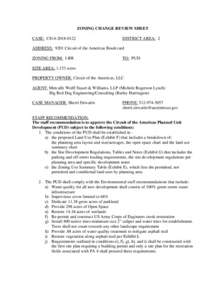
ZONING CHANGE REVIEW SHEET CASE: C814-2018-0122 DISTRICT AREA: 2 ADDRESS: 9201 Circuit of the Americas Boulevard ZONING FROM: I-RR TO: PUD SITE AREA: 1,153 acres PROPERTY OWNER: Circuit of the Americas, LLC AGENT: Metcalfe Wolff Stuart & Williams, LLP (Michele Rogerson Lynch) Big Red Dog Engineering/Consulting (Bailey Harrington) CASE MANAGER: Sherri Sirwaitis PHONE: 512-974-3057 sherri.sirwaitis@austintexas.gov STAFF RECOMMENDATION: The staff recommendation is to approve the Circuit of the Americas Planned Unit Development (PUD) subject to the following conditions: 1. The conditions of the PUD shall be established in - a) b) c) the proposed Land Use Plan (Exhibit F) that includes a breakdown of: the planning area layout and size/acreages, the open space chart and the land use summary chart the Site Development Regulations, Tables and Notes (Exhibit G) that includes the parking and off-street loading requirements, the site development regulations per planning area and specific development notes the Zoning Use Summary Table (Exhibit E), which lists the permitted, not permitted and conditional land uses by planning area 2. The PUD shall comply with the Environmental staff recommendations that include: a) Water quality for all new development shall consist of 100% green storm water infrastructure b) Impervious cover limited to 68% c) Dedicate 11.38 gross acres of parkland d) Provide 298 acres of Open Space e) Restore 14.36 acres of wetlands f) Re-permit and construct US Army Corps of Engineers creek restoration g) Install 400 native trees minimum size 2" caliper and water trees for establishment. Trees shall not count towards any other landscape requirement h) Provide .88 acres of water quality treatment to mitigate asphalt trail i) Restore vegetation along asphalt trail per Exhibit L j) Requirements outlined in conditions e), f), g), h), and i) shall be constructed with the first site plan requiring a building permit and only a site plan for the recreation fields associated with PA 4 shall proceed these requirements. C814-2018-0122 Page 2 k) The development of the PUD shall comply with the conditions stipulated in the Parks and Open Space Plan (Exhibit I). 3. The development of the PUD site will be subject to the attached TIA memorandum from the Austin Transportation Department (ATD) dated June 19, 2020 – Exhibit P. The TIA memo limits the site development to uses and intensities that will not exceed or vary from the projected traffic conditions assumed in the final TIA [prepared by WGI, dated June 18, 2020]. 4. The PUD zoning will be subject to draft language agreed upon with the Neighborhood Housing and Community Development Department (NHCD) concerning compliance with the affordable housing on the property (please see Note 5 on the PUD Land Use Plan (Exhibit F): “THE OWNER SHALL PAY A FEE-IN-LIEU FOR ANY BONUS AREA DEVELOPED WITHIN THE PUD. BONUS AREA SHALL INCLUDE ANY GROSS FLOOR AREA GREATER THAN THAT WHICH COULD BE ACHIEVED WITHIN THE HEIGHT, FLOOR AREA RATIO, AND BUILDING COVERAGE ALLOWED BY THE COMMERCIAL SERVICES ZONING DISTRICT. THEFEE-IN-LIEU AMOUNT SHALL BE EQUIVALENT TO THE BONUS AREA TIMES AND THE PLANNED UNIT DEVELOPMENT FEE RATE CURRENT AT THE TIME OS SITE PLAN SUBMITTAL. THE FEE-IN-LIEU SHALL BE PAID TO THE NEIGHBORHOOD HOUSING AND COMMUNITY DEVELOPMENT DEPARTMENT PRIOR TO THE ISSUANCE OF A FINAL CERTIFICATE OF OCCUPANCY FOR ANY DEVELOPMENT WITHIN THE PUD THAT INCLUDES BONUS AREA.” The applicant agrees with the staff’s recommendation. PARKS AND RECREATION BOARD ACTION: May 27, 2020: Motion made to recommend the Circuit of the Americas Planned Unit Development (PUD) as superior as it pertains to parkland (Vote: 6-0, R. Farasat, A. Di Carlo, K. Taylor-absent, S. Faust-abstained); L. Sajbel-1st, R. DePalma-2nd. ENVIRONMENTAL COMMISSION RECOMMENDATION: July 15, 2020: ZONING AND PLATTING COMMISSION RECOMMENDATION: CITY COUNCIL ACTION: ORDINANCE NUMBER: C814-2018-0122 ISSUES: N/A CASE MANAGER COMMENTS: Page 3 The applicant has submitted a zoning request for a 1,153 acre mixed use project generally located east of State Highway 130 and north of FM 812 on Circuit of the Americas Boulevard (see Case Map – Exhibit A). The proposed PUD consists of a mixed-use development and is comprised of eight planning Areas with approximately 967 acres of commercial space (Areas 1, 3, 4, 5, 6, 7, & 8) and 186 acres of mixed use (Area 2). The land use plan includes 298 acres of open space that is dispersed throughout Areas 3, 4, 5, 6 and 8 on the site (see PUD Land Use Plan – Exhibit F). The applicant is proposing the CS, General Commercial Services District, as the baseline zoning district for the PUD. The property in question was annexed in 2012 through Ordinance No. 20121108-027 and received the Interim-Rural Residence (I-RR) designation. The site is surrounded by residential and commercial properties within the City’s Extraterritorial Jurisdiction (ETJ) that do not have zoning and are not part of an active or near-future neighborhood planning effort. Although there are residential uses within 540 feet of the project, the majority of the properties are not located within the City of Austin and will not subject to compatibility requirements. The property is located within the Dry Creek East and Maha Watersheds, which are classified as Suburban Watersheds. The proposed PUD is in an area that includes the 100- year floodplain, stream buffers and critical environmental features. These features represent opportunities for expansion, restoration, or enhancement as PUD superiority elements. Development on portions of the property may be impacted by slopes (see Existing and Proposed Environmental Mitigation and CEFs - Exhibit K). The applicant is requesting PUD district zoning for a 1,153 acre mixed use project. According to the Yield sheet from Transportation Impact Analysis (TIA), the proposed PUD may include up to 30 residential condo units, a 508 unit/room hotel use, 120,000 sq. ft. of light industrial uses, a water slide park, an 11 field soccer complex, a 170,000 sq. ft. indoor sports facility, a 20,000 sq. ft. e-sports arena, 70,000 sq. ft. of museum uses, 150,000 sq. ft. of general office uses and 50,000 sq. ft. of shopping center/retail uses. The applicant will be dedicating 11.38 gross acres/9.71 net credited acres of parkland on Area 8, a 20-foot urban trail easement along Area 4 and 298 acres of open space on planning Areas 3, 4, 5, 6 and 8 of the PUD. (Please see Exhibit I: Parks and Open Space Plan). C814-2018-0122 Page 4 BASIS OF RECOMMENDATION 1. The proposed zoning should be consistent with the purpose statement of the district sought. The Planned Unit Development (PUD) zoning district is intended for large or complex developments under unified control, planned as a single contiguous project. The PUD is intended to allow single or multi-use projects within its boundaries and provides greater design flexibility for development proposed within the PUD. Use of the PUD district should result in development superior to that which would occur using conventional zoning and subdivision regulations. PUD zoning is appropriate if the development enhances preservation of the natural environment; encourages high quality development and innovative design; and ensures adequate public facilities and services for development within the PUD. 2. Zoning changes should result in a balance of land uses, provides an orderly and compatible relationship among land uses and incorporates environmental protection measures. The proposed PUD zoning will permit a high quality, mixed use development that will provide for employment opportunities in an area that has been identified by the Growth Concept Map in the Imagine Austin Comprehensive Plan as being within a designated “Job Center”. The staff recommends PUD zoning based on the following factors: contribution to affordable housing, participation in the Art in Public Places Program, environmental superiority, drainage improvements, compliance with at least a 2-star Green Building regulations, provision for 298 acres of open space/ including parkland and community recreation areas, transportation roadway and intersection improvements, and utility facility improvements that will provide for a superior development at this location. 3. Zoning should allow for reasonable use of the property. The proposed PUD zoning will enable the applicant to expand the existing Outdoor Entertainment use that was approved on the property through site plan case SP-2011- 0053D to create a mixed use development that will include a 358-room hotel, a 150- room hotel, a water slide park with 416 parking spaces, a soccer complex with 11 fields, 30 dwelling units of recreational homes, 150,000 square feet of general office use, 50,000 square feet of shopping center uses, 120,000 square feet of general light industrial uses, 70,000 square feet of museum use, a 170,000 square foot indoor sports facility, and a 20,000 square foot e-sports arena. C814-2018-0122 Page 5 PURPOSE OF PLANNED UNIT DEVELOPMENTS Per the Land Development Code, PUD district zoning was established to implement goals of preserving the natural environment, encouraging high quality development and innovative design, and ensuring adequate public facilities and services. The City Council intends PUD district zoning to produce development that achieves these goals to a greater degree than and thus is superior to development which could occur under conventional zoning and other development-related regulations. The City Council approved revisions to the PUD regulations that became effective June 29, 2008. To help evaluate the superiority of a proposed PUD, requirements are divided into two categories: Tier 1, which is requirements that all PUDs must meet, and Tier 2 which provides criteria in 13 topical areas in which a PUD may exceed Code requirements and therefore demonstrate superiority. A PUD need not address all criteria listed under Tier 2, and there is no minimum number of categories or individual items required. PROPOSED CODE MODIFICATIONS There are 10 modifications to Code and Criteria Manual requirements requested by the Applicant (please refer to Exhibit D – Proposed Code Modifications for details). These proposed modifications are summarized below: • Chapter 25-1 (GENERAL REQUIREMENTS AND PROCEDURES), Article 2 (Definitions; Measurements), Section 25-1-21(103) (Site) – Revises the definition of Site to allow a site to cross a public street or right-of-way if that public street or right- of-way is within the boundaries of The Grove at Shoal Creek PUD. • Chapter 25-2 (ZONING), Article 2 (Principal Use and Development Regulations), Section 25-2-243 (Proposed District Boundaries Must Be Contiguous) – To allow for the PUD boundaries to cross right-of-way and not be contiguous. • Chapter 25-2 (ZONING), Article 2 (Principal Use and Development Regulations), Section 25-2-491 (Permitted, Conditional and Prohibited Uses) – To allow for a specific set of permitted, conditional and prohibited uses to be applicable per Exhibit E – Zoning Use Summary Table. • Chapter 25-2 (ZONING), Article 2 (Principal Use and Development Regulations), Section 25-2-492 (Site Development Regulations) – To propose that the site development regulations applicable to the Property be as shown on Exhibit G – Site Development Standards Table. • Chapter 25-2 (ZONING), Article 10 (Compatibility Standards) – To state that Compatibility Standards do not apply within the PUD. However, Compatibility Standards will apply where development outside of the PUD triggers these standards for development within the PUD. C814-2018-0122 Page 6 • Chapter 25-2 (ZONING), Subchapter E (Design Standards and Mixed Use) – To request to that the requirements of Subchapter E not apply to development of the property within the PUD. • Chapter 25-6 (TRANSPORTATION), Section 25-6 (APPENDIX A – Tables of Off- Street Parking and Loading Requirements) – To reduce parking required to a determined amount. To allow for shared parking analysis based on mix of uses. • Chapter 25-8 (ENVIRONMENT), Article 7 (Requirements in all Watersheds), Division 1. – Critical Water Quality Zoned Restrictions, Section 25-8-262(B)(1) (Critical Water Quality Zone Street Crossings) – To allow for the existing thirty (30) foot trail of decomposed granite and hard surface to cross a major critical water quality zone regardless of if it is identified in the Transportation Plan. • Chapter 25-8 (ENVIRONMENT), Article 7 (Requirements in all Watersheds), Division 5. –Cut, Fill and Spoil, Section 25-8-341 (Cut Requirements) and Section 25-8-342 (Fill Requirements) - To allow for cut and fill to exceed the 4 foot minimum and follow the requirements for Section 25-8-341(A)(1) and Section 25-8-41(A)(1) for tracts of land in an urban watershed. • Chapter 25-10 (SIGN REGULATIONS), Section 25-10-103 (Signs Prohibited in All Sign Districts) – To allow for one (1) off premise sign on Area 8 for the proposed parkland dedication area. SUPERIORITY ELEMENTS As more fully detailed in the Basis for Superiority - Tier 1 and Tier 2 Compliance Summary Table (Exhibit C) and on the proposed PUD Land Use Plan (Exhibit F), this proposed PUD meets the applicable Tier 1 items and offers some elements of superiority in seven Tier 2 categories (Open Space/Parkland; Environment/Drainage; Art; Community Amenities, Transportation, Parking Structure and Affordable Housing). The applicant is proposing the following benefits for the PUD: Affordable Housing Providing for fee in lieu donation per 2.5.6 Development Bonus. Art Participate in the Art in Public Places Program. The applicant will provide for either 5 pieces of public art at a minimum budget of $250,000 or donation of $250,000 to the AIPP Program. Onsite art will be developed and managed by the owner/developer. Community Amenities Dedicating land and constructing community soccer fields that are open to the public. C814-2018-0122 Page 7 Environmental/Water Quality Complying with current code. Provide for compliance with the Commercial Landscape Ordinance, which applies to irrigation, landscaping and use of innovative water management options such as directing stormwater to on-site uses (e.g., landscaping). Provide for an Integrated Pest Management Plan (IPM) plan, when not required. The PUD shall utilize green stormwater infrastructure for 100% of the provided stormwater treatment for new development. Provide an additional 14.36 acres of Blackland Prairie restoration Provide alternative water supply as the primary water source for irrigation. Tree Plantings use Central Texas seed stock native. Proposing an impervious cover limitation of 68% on the overall COTA PUD. 400 additional 2” caliper native trees planted beyond original Exhibit A commitment Green Building Comply with at least a 2-star Green Building requirement. Grow Green Landscaping Commitment to Grow Green Native and Adapted Landscape Plants List and Invasive Species/Problem Plants List when not required. Parkland and Open Space Providing for 10% above minimum with private and public open space. Provide for 298 acres of open space. A total amount of open space that is equal to 26% as the development is a mix of uses. Provide for 20-foot easement for future Urban Trails Master Plan Tier II trail. Dedicate 11.38 acres of gross parkland (9.71 credited) beyond the 7.81 acres required. Construct community soccer fields that are open to the public. Private open space around track, hotel, and stadium areas. Parking Structure Commercial or Mixed Use buildings will comply. Public Facilities Transportation SERs are currently under review by the Austin Water Utility. Any additional utility needs related to sizing and routing will be finalized prior to the formal PUD submittal. Providing for public/community soccer fields. Provide for an appropriate network of roads, trails and sidewalks connections that will connect through project to existing and planned facilities. Provide for shower facilities for office development. C814-2018-0122 Page 8 LAND USES Outdoor Entertainment (Circuit of the Americas Racetrack, Austin360 Outdoor Amphitheater), Undeveloped Land Residential, Undeveloped Tracts, Aviation Facilities (Austin-Bergstrom Airport) Religious Assembly, Library, Service Station, Food Sales, Retail Services, Restaurant, RV Park, Residential, Undeveloped Single Family Residential, RV Park, Undeveloped Land Single Family Residential, Commercial SCENIC ROADWAY: No EXISTING ZONING AND LAND USES: Site I-RR ZONING North County South County East County West SF-4A, P TIA: Required (Please see TIA Memorandum – Exhibit P) WATERSHEDS: Dry Creek and Maha Watersheds CAPITOL VIEW CORRIDOR: No NEIGHBORHOOD ORGANIZATIONS: Bike Austin Del Valle Community Coalition Del Valle Independent School District Elroy Neighborhood Association Friends of Austin Neighborhoods Neighborhood Empowerment Foundation Onion Creek Homeowners Association Sierra Club, Austin Regional Group SCHOOLS: Del Valle Independent School District Popham Elementary School Del Valle Middle School Del Valle High School AREA CASE HISTORIES: NUMBER C14-2014-0182 (Moore’s Crossing 7.9 Acre Rezone: 7400 McAngus Road) REQUEST GR to SF-4A COMMISSION 2/25/15: Approved staff’s rec. of SF-4A by consent CITY COUNCIL 3/26/15: Approved PC rec. of SF-4A by consent on all 3 readings Page 9 P, SF-2 to SF-4A 8/17/07: Approved staff rec. of SF-4A (7-0) 11/08/07: Approved SF-4A (6-0); all 3 readings C814-2018-0122 C14-2007-0016 (Stoney Ridge Phase D: Elroy Road and Kellum Lane) RELATED CASES: Development Assessment A Development Assessment for the Circuit of the Americas PUD was submitted on May 14, 2018. In accordance with the revised regulations for PUDs, a briefing was presented to Council on August 23, 2018 (CD-2018-0004). On September 28, 2018, the Applicant filed this PUD zoning application. Annexation November 8, 2012 through Ordinance No. 20121108-027 Site Plan SP-2011-0053D Resolution Resolution 20120629-002: Permitted the City Manager to negotiate and execute an agreement with the Circuit of Americas OTHER STAFF COMMENTS: Austin Water Facility Engineering • The proposed buildings will be constructed using a dual distribution pipe system to allow all non-potable water uses within the buildings to be met by an alternative water supply (with provision for a potable back-up supply). The Landowner should consider constructing one or more onsite water reuse systems (collection and treatment of rainwater, graywater, stormwater, condensate water or pool backwash and drain water) as an alternative water supply to the buildings. • The Landowner shall use an alternative water supply as the primary water source for all landscape irrigation within the COTA PUD. Potable water, by way of an AW irrigation meter, shall only be used as a backup supply if the primary sources are depleted. • Through coordination with the Service Extension Request (“SER”) process to ensure adequate capacity and meet infrastructure planning goals, the Landowner will provide Austin Water Utility Development Services more detail on the Circuit of the Americas PUD Expansion proposal, especially regarding the potential water park on the site. C814-2018-0122 Page 10 Comprehensive Planning I-RR to PUD Please note, a development assessment for this project was submitted in May 2018 and a compliance review was also completed. Staff stated that the proposed PUD was partially supported by Imagine Austin but needed more information to make a more complete assessment of this project and also pointed out issues regarding the lack of mobility within and connecting to the outside of the project area. The proposed PUD mixed use project is situated on 1,154 acres at the Circuit of America site, which is a sports and entertainment venue. The Circuit of America site contains an F1 racetrack and the 6,700 seat Austin360 outdoor amphitheater. The proposal is to expand development on the site, consisting of seven planning areas: six commercial area; and one mixed use area with a proposed base district of CS, which will include but not be limited to: commercial, retail, warehouses, parks, a parkland trail, a community garden, hotels, a campground/RV park, a business park, office uses, indoor and outdoor sports and recreational uses, a museum, and mixed residential components. The property is not located within a neighborhood planning area. The property is bounded by FM 812 to the south; and Elroy Road to the east and north. Surrounding land uses includes housing, vacant land, and Austin-Bergstrom Airport to the north; two churches, a library, retail uses (gas station, retail, restaurant), an RV park, housing and vacant land to the south; single family housing, an RV park, and vacant land to the east; and vacant land, single family housing and commercial uses to the west. The developer stated in a letter that they want the project to serve as a hub for growth in the eastern corridor of Austin. The following is the PUD proposal: • Open Space and the Environment, the developer proposes that: 24 percent of the property (248 acres) will be devoted to open space, exceeding the PUD requirement of 10 percent open space; provide a boardwalk on wet pond amenity; preserve a significant amount of the wetland in the project area, which will be restored and improved; submit a C814-2018-0122 Page 11 variance on the impervious surface coverage to be based on the entire PUD site, not just contiguous area; allow for arterial or collector street to cross a major critical water quality zone (cross the flood plain to CWQZ to allow for connectivity through the site); exemption to the requirement of Division 3 to allow the Urban Watershed Exemption of 25-8-304 to allow for ‘reasonable use of the land’; allow development within 20 linear ft. of certain wetlands with restoration; remove CEF setbacks for wetlands that are being utilized water quality ponds; and allow cut and fill to exceed the 4 ft. minimum and follow the requirements for urban watersheds. The PUD will enhance the preservation of the natural environment by including significant open space for pedestrians and bicycle trail connections and the preservation of the Dry Creek Corridor. • Mobility, the developer proposes to: provide a network of roads, multi-use shared trail, bike lanes and public sidewalks throughout the project area. They also want to provide showers in office development to allow people to commute to the site and use the shower; comply with Great Streets Program; comply with Suburban Roadway standards; request a variance of Internal Circulation Route standards; request variance to allow for shared parking; and commit to contacting CapMetro every five years regarding future transit services. • Great Streets: Provide PUD Tier 2 standards. • The Buildings, the developer proposes that: the project will encourage high quality development and innovative design. • Affordability, the developer proposes to: provide fee in lieu for affordable housing development bonus; and • Community Amenities and Civic, the developer proposes to: provide for public art master plan, which will be developed and managed by the owner/developer; provide for community soccer fields that are open to the public; public area will also be located within the project area. No specifics were given regarding the square footage, building heights, or the mix of commercial, office, civic, and residential uses in the PUD file to review. Preliminary building layouts are shown on the site plan. In the development assessment submittal, Tracts 2 and 5 were designated for the construction of 200 ft. and 220 ft. tall buildings. Connectivity There are no internal public sidewalks along Circuit of the Americas Blvd. There are also no public sidewalks or public transit stops located along Elroy Road. The Walkscore for this property is 1/100, Car Dependent, meaning almost all errands require a car. There are no existing urban trails located within a ½ of this site. C814-2018-0122 Page 12 Imagine Austin and Conclusions Growing as a ‘compact and connected city’ to create ‘complete communities’ is the basis of the Imagine Austin vision statement and the hundreds of policies and actions developed throughout the plan. Growing as a compact and connected city,”… enhances human connections, innovation, and urban vibrancy. Creating a more compact and efficient city is critical to our ability to connect people to homes, jobs, schools, and other destinations with a more complete transportation system that is affordable to build, operate, and maintain. (p 10) The Imagine Austin Growth Concept Map also identifies this property as being within a “Job Center” on the map, which was placed on the IAGCM in support of the F1 racetrack, and to support a variety of land uses associated with this large scale sports and entertainment venue. Page 107 of the IACP states, “Job centers accommodate those businesses not well-suited for residential or environmentally sensitive areas. These centers take advantage of existing transportation infrastructure such as arterial roadways, freeways, or the Austin-Bergstrom International Airport. Job centers will mostly contain office parks, manufacturing, warehouses, logistics, and other businesses with similar demands and operating characteristics. They should nevertheless become more pedestrian and bicycle friendly, in part by better accommodating services for the people who work in those centers. While many of these centers are currently best served by car, the Growth Concept Map offers transportation choices such as light rail and bus rapid transit to increase commuter options.” The proposed PUD mixed use project appears to contribute towards making this area a more complete community by including a mixture of uses (live, work and play) in an area that offers few of these options outside the Circuit of America site. The property is also located within a designated Imagine Austin ‘Job Center’ that is intended to support further development within the project area. However, due to the lack of mobility and connectivity options outside the project area, this proposed project appears to only partially support the mobility policies of the Imagine Austin Comprehensive Plan. It is hoped in the near future that mobility and connectivity options are available connecting to connect the project area to the surrounding area, including public transit, bike lanes and urban trails, so automobile usage is not the only option to reach this site. Drainage Engineering This project is located at 9201 CIRCUIT OF THE AMERICAS BLVD and is within the Maha Creek and Dry Creek East watershed(s), which are classified as Suburban Watershed. This project located within the Edwards Aquifer Contributing Zone. The City of Austin will be undergoing a change of precipitation values as per a study conducted by NOAA Atlas 14. Drainage is not a section of code that may be grandfathered. When the proposed plans come in, it is likely that new floodplain and drainage precipitation values will be made. Although the values are not yet defined, the floodplain delineation will be similar or less to that of the 500-year C814-2018-0122 Page 13 floodplain for reference and the rainfall values will be near 13” for the 100-year storm event. Applicant has acknowledged any future development may be required to meet the new rainfall data associated with Atlas 14. The requirements of the LDC and DCM in place at the time of future applications will apply. No further comment. Applicant has acknowledged no deviations are being requested, and no superior is being proposed for drainage purposes. The requirements of t place at the time of future applications will apply. No further comment. Please refer to Exhibit J through Exhibit L. Environmental Fire Please note: “All bulk chemical storage shall be reviewed and permitted with Austin Fire Department prior to facility installation or delivery. Bulk chemical storage within 300 feet of residential occupancies shall be prohibited or require additional reporting, risk assessments, and/or risk mitigation.” Floodplain Reviewer notes: Large portions of the PUD area are located within the mapped floodplains of Dry Creek East watershed. Currently the PUD documents show floodplain areas as open space. PUD documents show trails and a proposed parkland road creek crossing in the floodplain. FYI- As the PUD does not request changes or amendments to floodplain code and criteria, all future application in the PUD area will be required to meet floodplain regulations in effect at the time of application including but not limited to: prohibition of new buildings and parking located in the floodplain, requirements to demonstrate that all proposed development activities located within the floodplain do not adversely impact the floodplain on other property owners and all other floodplain regulations. FYI- Our understanding of flood risk in Austin is changing. What is now known as the 500- year floodplain is a good representation of what the 100-year floodplain will be according to a National Weather Service publication called Atlas 14. This could affect the layout of future developments in the PUD area, including the location of drainage easements, buildings, and parking areas. The City will likely be using the current 500-year floodplain as the design floodplain for site development permits review by the end of 2018/beginning of 2019. In order to minimize flood risk to our community and better ensure that this lot can be developed in the future, the City of Austin recommends that you consider the 500-year floodplain as a surrogate for the 100-year floodplain when designing developments within the PUD area. Please contact this reviewer if you have any questions. C814-2018-0122 Page 14 Impervious Cover Industrial Waste The overall project impervious cover is capped at 68%. The requirements under Chapter 15-10 of the Austin City Code (Wastewater Regulations) do not apply to this project based on the plans submitted. Neighborhood Housing and Community Development The following language has been sent to the applicant and the case manager to be included in the draft PUD ordinance: “THE OWNER SHALL PAY A FEE-IN-LIEU FOR ANY BONUS AREA DEVELOPED WITHIN THE PUD. BONUS AREA SHALL INCLUDE ANY GROSS FLOOR AREA GREATER THAN THAT WHICH COULD BE ACHIEVED WITHIN THE HEIGHT, FLOOR AREA RATIO, AND BUILDING COVERAGE ALLOWED BY THE COMMERCIAL SERVICES ZONING DISTRICT. THEFEE-IN-LIEU AMOUNT SHALL BE EQUIVALENT TO THE BONUS AREA TIMES AND THE PLANNED UNIT DEVELOPMENT FEE RATE CURRENT AT THE TIME OS SITE PLAN SUBMITTAL. THE FEE-IN-LIEU SHALL BE PAID TO THE NEIGHBORHOOD HOUSING AND COMMUNITY DEVELOPMENT DEPARTMENT PRIOR TO THE ISSUANCE OF A FINAL CERTIFICATE OF OCCUPANCY FOR ANY DEVELOPMENT WITHIN THE PUD THAT INCLUDES BONUS AREA.” This language has been added as Note 5 on the PUD Land Use Plan (Exhibit F). No further comments. All comments cleared. Site Plan review has been approved. Addition of any public or private streets will require a preliminary plan. Platting will be required for any development on any portion of the site that has not yet been platted. A Traffic Impact Analysis is required and has been submitted. Please see TIA memorandum from the Austin Transportation Department (ATD) dated June 19, 2020 – Exhibit P. Site Plan Subdivision Transportation C814-2018-0122 Water and Wastewater Page 15 FYI: The landowner intends to serve the site with City of Austin water and wastewater utilities. The landowner, at own his expense, will be responsible for providing any water and wastewater utility improvements, offsite main extensions, water or wastewater easements, utility relocations and/or abandonments required by the proposed land uses. SERs have been approved for this development and are applicable. Water and wastewater utility plans must be reviewed and approved by the Austin Water Utility in compliance with Texas Commission of Environmental rules and regulations, the City’s Utility Criteria Manual and suitability for operation and maintenance. All water and wastewater construction must be inspected by the City of Austin. The landowner must pay the City inspection fees with the utility construction. The landowner must pay the tap and impact fee once the landowner makes an application for a City of Austin water and wastewater utility tap permit. Typical water system operating pressures in the area are above 65 psi. Pressure reducing valves reducing the pressure to 65 psi (552 kPa) or less to water outlets in buildings shall be installed in accordance with the plumbing code. All AWU infrastructure and appurtenances must meet all TCEQ separation criteria. Additionally, AWU must have adequate accessibility to safely construct, maintain, and repair all public infrastructure. Rules & guidelines include: 1. A minimum separation distance of 5 feet from all other utilities (measured outside of pipe to outside of pipe) and AWU infrastructure; 2. A minimum separation distance of 5 feet from trees and must have root barrier systems installed when within 7.5 feet; 3. Water meters and cleanouts must be located in the right-of-way or public water and wastewater easements; 4. Easements for AWU infrastructure shall be a minimum of 15 feet wide, or twice the depth of the main, measured from finished grade to pipe flow line, whichever is greater. 5. A minimum separation of 7.5 feet from center line of pipe to any obstruction is required for straddling line with a backhoe; 6. AWU infrastructure shall not be located under water quality or detention structures and should be separated horizontally to allow for maintenance without damaging structures or the AWU infrastructure. 7. The planning and design of circular Intersections or other geometric street features and their amenities shall include consideration for access, maintenance, protection, testing, cleaning, and operations of the AWU infrastructure as prescribed in the Utility Criteria Manual (UCM) C814-2018-0122 Page 16 8. Building setbacks must provide ample space for the installation of private plumbing items such as sewer connections, customer shut off valves, pressure reducing valves, and back flow prevention devices in the instance where auxiliary water sources are provided. FYI: Dedication of private streets and public utility easements does not obligate the City to approve the placement of City water and wastewater mains within same. Water and wastewater service shall be provided to each lot at their Right of Way frontage. INDEX OF EXHIBITS TO FOLLOW Exhibit A: Zoning Map Exhibit B: Aerial Map Exhibit C: Basis for Superiority - Tier 1 and Tier 2 Compliance Summary Exhibit D: Proposed Code Modifications to Development Regulations Exhibit E: Zoning Use Summary Table Exhibit F: Circuit of the Americas PUD Land Use Plan Exhibit G: Site Development Regulations, Tables and Notes Exhibit H: Existing and Proposed Site Layout Exhibit I: Parks and Open Space Plan Exhibit J: Cut and Fill Exhibit Exhibit K: Existing and Proposed Environmental Mitigation and CEFs Exhibit L: Restoration Planting Details Exhibit M. Grow Green Native and Adapted Landscape Plants List Exhibit N: Horizon – USACE Permit Exhibit O: Carbon Impact Statement Exhibit P: TIA Memorandum (( ( ( ( ( ( ( ( ( ( ( ( ( ( ( SF-2 ( ( ( ( ( ( ( SF-2 (( ( ( ( ( ((( RR SF-2 P GR C14-2014-0182 SF-4A P ( COUNTY SF-2 C12M-2016-0006 SF-4A SP-06-0247DS ! ! ! ! ! ! ! ! ! ! ! ! ! ! ! ! ! ! ! ! ! ! ! ! ! ! ! ! ! ! ! ! ! ! ! ! ! ! ! ! ! F ! M 812 R ! D ! C12M-2016-0006 ELR O Y R D C14-2007-0016 2007-0016 ! ! ! D S R ! U G ! N C A ! M ! ! ! ! ! ! ! ! ! ! ! ! ! ! ! ! ! ! ! ! ! ! ! ! ! C I R C U I T O F T H E A M E R I C A S B L V D I-RR 86-155 EXHIBIT A I-RR D M R A L L E K ! ! ! SF-2 SF-4A ! ! ! ! ! ! ! ! ! ! ! ! ! ! ! ! ! ! ! ! ! ! ! ! ! 86-155 P ! ! ! ! ! ! ! ! ! ! ! ! ! ! ! ! ! ! ! ! ! ! ! ! ! ! ! ! ! ! ! ! ! ! ! ! ! ! ! ! ! ! ! ! ! ! ! ! ! ! ! ! ! ! ! ! ! ! ! ! ! ! ! ! ! ! ! ! ! ! ! JA C O B S O N R D ! ! ! ! ! ! ! ! ! ! ! ! ! ! ! ! ! ! ! ! ! ! ! ! ! ! ! ! ! ! ! ! ! L A R K D A L E L N R S D WIS ALP B E R S S D R N D R R H O N V E V E E D R G E N E V Y D R R E D PIN A D R L A P L O V E R P L ! ! ! ! ! ! ! ! ! ! ! ! ! ! ! ! ! ! ! ! ! ! !! ! ! ! ! ! ! F M 8 1 ! ! 2 ! ! ! R D ! ! ! ! ! ! ! ! ! ! PILA ! N ! D TRIA ! N ! GLE ! ! ! ! ! !! ! ! D S R M R D FA N U L K R U B M A R T I N L N PLANNED UNIT DEVELOPMENT ZONING CASE#: C814-2018-0122 ± SUBJECT TRACT ! ! ! ! ! ! PENDING CASE ZONING BOUNDARY This product is for informational purposes and may not have been prepared for or be suitable for legal, engineering, or surveying purposes. It does not represent an on-the-ground survey and represents only the approximate relative location of property boundaries. 1 " = 1,420 ' This product has been produced by CTM for the sole purpose of geographic reference. No warranty is made by the City of Austin regarding specific accuracy or completeness. EXB•DITD N C SUBJECT TRACT D PENDING CASE A l = ! ZONING BOUNDARY - CREEK BUFFER 1" = 2000' � POTENTIAL FLOOD AREAS CIRCUITS OF THE AMERICAS PUD ZONING CASE#: C814-2018.0122 LOCATION: 9201 CIRCUITS OFTHEAMERICAS BLVD SUBJECT AREA: 1153 ACRES GRID: N11, P10, P11, P12, Q10, 011, & 012 MANAGER: SHERRI SIRWAITIS This map has been pnxluced by the Communlcalions Technology Management Dept. on blhall' of Illa P111nnlng Developmenl RIYiaw Dept for lhe aa11 purpose or geographic reference No Wlmlnl)' Is made by lhe City DI AusUn reganllng 1pecllic .,,.,,rarv rv ""'""*-1.,,.•• CIRCUIT OF THE AMERICAS PUD – C814-2018-0122 Basis for Superiority and Recommendation Exhibit ___ July 2020 EXHIBIT C EXISTING ZONING: I-RR BASELINE PROSED: CS Item *TIER 1* 11 items General Code Requirement PUD Proposal/Superiority PUD: Tier1A – (MEET) Meet the objectives of the City Code PUD: Tier1B – (MEET) Provide for development standards that achieve equal or greater consistency with general PUD intent and exceed standard Code regulations 1. Providing for environmental, community, design and regional goals that meet or exceed Code standards and encourages high quality mixed use in the Desired Development Zone near SH130 and Hwy. 71. 2. Encouraging high quality, mixed use development with open space areas. 3. Provides for a mixed-use project adding employment opportunities and is identified near a Job Center Node that is in line with the Imagine Austin Plan. Open Space/Parkland PUD Tier 1C – (MEET) Provide open space at: 10% Residential 15% Industrial 20% Commercial 1. Providing for a total amount of open space that is equal to 26% as the development is a mix of uses. Green Building Program PUD Tier 1D – (MEET) Comply with Green Building Program 1. Providing for 2-Star Green Building for all development. Neighborhood Plans and Historic PUD Tier 1E – (N/A) Be consistent with neighborhood plans, 1. N/A 1 Compatibility Water Quality /Environmental historic and surrounding uses PUD Tier 1F – (MEET) Provide for environmental preservation Sed/Fill Pond Standard water quality requirement Public Facilities PUD Tier 1 G – (MEET) Provide for public facilities and services PUD Tier 1H – (MEET) Exceed minimum landscaping requirements PUD Tier 1i – (MEET) Provide appropriate transportation connections and mitigate impacts PUD Tier 1J – (MEET) Gated Roadways Prohibited PUD Tier 1K – (N/A) Protect areas of significance Grow Green Landscaping Connectivity Gated Roadways Architectural, historical, cultural and archaeological areas PUD Size and Uniqueness *ADDITIONAL* 3 ITEMS 1. Providing for compliance with the Commercial Landscape Ordinance, which applies to irrigation, landscaping and use of innovative water management options such as directing stormwater to on-site uses (e.g., landscaping) 2. Providing for an Integrated Pest Management Plan (IPM) plan when not required. 1. SERs are currently under review by the Austin Water Utility. Any additional utility needs related to sizing and routing will be finalized prior to the formal PUD submittal. 2. Providing for public/community soccer fields 1. Commitment to Grow Green Native and Adapted Landscape Plants List and Invasive Species/Problem Plants List when not required 1. Working with Travis County on existing roadway network surrounding the PUD; 2. Working on multi modal routes 3. Commit to contact Capital Metro every 5 years regarding future transit services 1. Gated roadways are generally prohibited. Due to large events such as F1 and concerts, private roads will have temporary gating or rerouting. N/A PUD Tier1L – (MEET) 10 acre size unless special issues 1. The PUD encompasses 1153 acres Commercial Design Standards PUD Additional Tier – Comply with CDS 1. Subchapter E standards are not able to be met related to designs needed for special events that involve large 2 volumes of people, vehicles, etc. Comply with Core Transit Corridor if in Urban Area PUD Additional Tier – (N/A) Pay Tenant Relocation Fee PUD Additional Tier - (MEET) Pedestrian oriented uses on the first floor of a multi-story commercial or mixed use building N/A comply. 1. Multistory commercial or mixed use buildings will Tenant Relocation Fee Pedestrian Oriented Uses *TIER 2* 13 ITEMS Open Space/Parkland PUD Tier 2 – (MEET) Provide 10% above minimum or enhancements to trails and open space Environment/Drainage PUD Tier 2 – (MEETS) Complies with current code Provide various environmental options 1. Providing for 10% above minimum with private and 2. Providing for 20 foot easement for future Urban Trails public open space Master Plan Tier II trail 3. Dedicating 11.38 acres of gross parkland (9.71 credited) beyond 7.81 acres required and constructing community soccer fields that are open to the public 4. Private open space around track, hotel, and stadium areas 1. Complying with current code 2. The PUD shall utilize green stormwater infrastructure for 100% of the provided stormwater treatment for new development. 3. Providing an additional 14.36 acres of Blackland Prairie 4. Providing alternative water supply as the primary water restoration source for irrigation. 5. 400 additional 2” caliper native trees planted beyond original Exhibit A commitment 6. Tree Plantings use Central Texas seed stock native. 7. Proposing an impervious cover limitation of 68% on the overall COTA PUD 3 Great Streets PUD Tier 2 Austin Energy Green Building Art Community Amenities Transportation Building Design PUD Tier 2 Provides a rating of three stars or above PUD Tier 2 Provide for art approved by the Art in Public Places Program in open spaces, either by providing the art directly or by making a contribution to the City’s Art in Public Places Program or a successor program. Complies with Great Streets Program PUD Tier 2 – (MEETS) Provide for various community services and amenities such as plazas and space for community meetings Provides publicly accessible multi-use trail and greenway along creek or waterway. PUD Tier 2 Provide bicycle facilities that connect to existing or planned bicycle routes or provides multi-modal transportation features not required by code. other PUD Tier 2 Exceeds minimum points required by the Building Design Options of Subchapter E 1. Providing for either 5 pieces of public art at a minimum budget of $250,000 or donation of $250,000 to the AIPP Program. Onsite art will be developed and managed by the owner/developer. 1. Dedicating land and constructing community soccer fields that are open to the public. 1. Providing for an appropriate network of roads, trails and sidewalks connections that will connect through project to existing and planned facilities 2. Providing for shower facilities for office development Parking Structure PUD Tier 2 1. Commercial or Mixed Use buildings will comply. 4 1. Providing for in lieu donation per 2.5.6 Development Frontage At least 75 percent of building frontage Affordable Housing Historic Preservation Accessibility Local Small Business PUD Tier 2 of parking structures designed for pedestrian oriented uses in commercial or mixed use buildings PUD Tier 2 Provide for affordable housing onsite or in programs PUD Tier 2 – (N/A) Preserve historic structures, features and landmarks to a degree exceeding applicable legal requirements PUD Tier 2 Provides for accessibility for persons with disabilities exceeding applicable legal requirements Provides space at affordable rates to one or more independent retail or restaurant small business whose principal place of business is in the Austin metropolitan statistical area Bonus 1. N/A PUD Ordinance Summary 1. Meets 11 of 11 Tier 1 items (2 N/A) 2. Meets 2 of 3 Tier 1 additional items (1 N/A) 3. Meets 7 of 13 Tier 2 items (1 N/A) 5 Proposed Code Modifications to Development Regulations CIRCUIT OF THE AMERICAS PUD C814-2018-0122 July 2020 Code Section Code Section Description Proposed PUD Regulations Justification EXHIBIT D 25-1-21(98) Definition of Site Defines site as a contiguous area. • To amend the definition of site to allow impervious cover to be calculated based on the entire PUD 25-2-243 (A) Proposed District Boundaries Must Be Contiguous Districts proposed in a zoning application must be contiguous • To allow for the PUD district boundaries to cross right-of- way and not be contiguous 25-2-491 Permitted, Prohibited and Conditional Uses Outlines standard permitted, conditional and prohibited uses for CS zoning district. • Allow for a specific set of permitted, conditional and prohibited uses to be applicable per the Zoning Use Summary Table Exhibit 4. 25-2-492 Site Development Standards Outlines standard site development regulations for CS zoning districts. • Allow for a specific set of site development regulations by PUD Area per the Site Development Standards Table Exhibit 5. • The site operates holistically with different uses feeding off each other. Limiting individual site to impervious cover on such a large area will detract from the site experience and create difficulties with regional drainage and water quality facilities • A 112 acre tract across Elroy Road is proposed to be added to the PUD • The PUD is proposing denser uses in a compact and connected form in an effort to prevent sprawl around the PUD. • The PUD is proposing for denser uses in a compact and connected form in an effort to prevent sprawl around the PUD and respect existing natural buffers Code Section Code Section Description Proposed PUD Regulations Justification 25-2, Article 10 Compatibility Standards Outlines compatibility standards between certain uses • Compatibility regulations do not apply within the PUD 25-2 Subchapter E Commercial Design Standards Outlines design standards applicable to certain zoning and uses. • Commercial Design Standards are not applicable with as few exceptions as possible • The PUD is proposing a dense, mix of synergistic uses that are intended to complement each other rather than require buffers and setbacks that are unnecessary in this particular PUD • Due to the unusual nature of the existing site improvements and proposed site improvements as an entertainment and sports district, the prescribed standards cannot easily be employed. Specifically, moving thousands of people for large events must be accommodated on roads, pathways and sidewalks that require designs that are not aligned with Subchapter E - 2 - Code Section Code Section Description Proposed PUD Regulations Justification 25-6 Parking Ratio Requirements Defines parking ratios for sites Reduce parking to determined amount Allow for shared parking analysis based on mix of uses 25-8-262(B)(1) (Critical Water Quality Zone Street Crossings) Allows for an arterial street to cross a major critical water quality zone if identified in the Transportation Plan. Allow for the existing 30 foot trail composed of decomposed granite and hard surface to cross a major critical water quality zone regardless of if it is identified in the Transportation Plan. • There are overlapping and complementary uses on site that can share parking. • Peak usage will not require standard COA parking requirements • The original site permit allowed for a 30 foot trail to cross the CWQZ. The trail is a mix of decomposed granite and hard surface and while wider than 12 feet per Code, allows for continued connectivity for pedestrians and for limited maintenance. • The trail will be limited to pedestrians, bicycles and other such modes as permitted by code for multi-use trails. Physical barriers will be placed at the trail entrances to prevent non-permitted motorized vehicles other than maintenance vehicles from using the trail. - 3 - Code Section Code Section Description Proposed PUD Regulations Justification 25-8-341 (Cut Requirements) and 25-8-342 (Fill Requirement)s Outlines regulations for cut and fill. Allow for cut and fill to exceed the 4 foot minimum and follow the requirements for 25-8-341(A)(1) and 25-8-41(A)(1) for urban watersheds 25-10-103(1) (Off Premise Sign) Prohibits an Off Premise Sign Allow for one off premise sign on Area 8 for the proposed parkland dedication area. • Additional water quality for 0.88 acres of currently untreated trail to be provided • There are a significant amount of wetlands on the site that are being preserved and improved, and given the sites topography it will be important to be able to adjust existing site contours of the non- wetland areas to allow for reasonable use of the land. • The original D permit for the site allowed 26 foot cut/fill • Specific areas for this modification are identified on PUD Plan Sheet 6. • The proposed parkland dedication area requires signage that will be off- premise as the land will not be platted. - 4 - CIRCUIT OF THE AMERICAS (COTA) EXPANSION PUD C814-2018-0122 ZONING USE SUMMARY TABLE MAY 2020 Land Use Area 6 Area 5 Conference Entertainment District CS +Stadium District CS Area 4 Resort + Sports District CS Area 3 Business + Car Club District CS Area 2 Hospitality + Car Enthusiast District CS Area 1 Amusement District CS Area 7 COTA + Track District CS Area 8 Commercial + Parkland District CS RESIDENTIAL USES Bed & Breakfast (Group 1) Bed & Breakfast (Group 2) Condominium Residential Duplex Residential Group Residential Mobile Home Residential Multifamily Residential Retirement Housing (Small Site) Retirement Housing (Large Site) Single-Family Attached Residential Single-Family Residential P = Permitted General Notes: • P P NP NP NP NP NP NP NP NP NP P P NP NP NP NP NP NP NP NP NP P P NP NP NP NP NP NP NP NP NP P P NP NP NP NP NP NP NP NP NP P NP NP P P P P P P NP P P P NP NP NP NP NP NP NP NP NP P P NP NP NP NP NP NP NP NP NP NP = Not Permitted C = Conditional Use Industrial Uses are subject to LDC 25-2-648 EXHIBIT E P P NP NP NP NP NP NP NP NP NP 1 Land Use Area 6 Area 5 Conference Entertainment District CS +Stadium District Area 4 Resort + Sports District Area 3 Business + Car Club District CS Area 2 Hospitality + Car Enthusiast District CS Area 1 Amusement District CS Area 7 COTA + Track District CS Area 8 Commercial + Parkland District CS Small Lot Single- Family Residential Townhouse Residential Two-Family Residential Short-Term Rental COMMERCIAL USES Administrative and Businesses Offices Agricultural Sales and Services Alternative Financial Services Art Gallery Art Workshop Automotive Rentals Automotive Repair Services Automotive Sales Automotive Washing (of any type) Bail Bond Services Building P = Permitted General Notes: • NP NP NP NP P NP NP P P P P P P NP NP CS NP NP NP NP P NP NP P P P P P P NP NP NP NP P NP NP P P P P P P NP P P P P P P P P P P NP NP CS NP NP NP NP P NP NP P P P P P P NP NP NP NP NP NP P NP NP P P P P P P NP NP NP NP NP NP P NP NP P P P P P P NP P NP NP NP NP P NP NP P P P P P P NP P 2 NP = Not Permitted C = Conditional Use NP NP NP P NP NP Industrial Uses are subject to LDC 25-2-648 Land Use Area 6 Area 5 Conference Entertainment District CS +Stadium District CS Area 4 Resort + Sports District CS Area 3 Business + Car Club District CS Area 2 Hospitality + Car Enthusiast District CS Area 1 Amusement District CS Area 7 COTA + Track District CS Area 8 Commercial + Parkland District CS Maintenance Services Business or Trade School Business Support Services Campground Carriage Stable Cocktail Lounge Commercial Blood Plasma Center Commercial Off- Street Parking Communication Services Construction Sales and Services Consumer Convenience Services Consumer Repair Services Convenience Storage Drop-Off Recycling Collection Facility Electronic Prototype P = Permitted General Notes: • P P NP NP P NP P P P P P NP P P P NP NP P NP P P P P P NP P P P P NP P NP P P P P P NP P P P P NP P NP P P P P P NP P P P P NP P NP P P P P P NP P P P NP NP P NP P P P P P NP P P P P NP P NP P P P P P NP P NP NP NP NP NP NP NP NP = Not Permitted C = Conditional Use Industrial Uses are subject to LDC 25-2-648 P P P NP P NP P P P P P P NP P 3 Land Use Area 6 Area 5 Conference Entertainment District CS +Stadium District CS Area 4 Resort + Sports District Area 3 Business + Car Club District CS Area 2 Hospitality + Car Enthusiast District CS Area 1 Amusement District CS Area 7 COTA + Track District CS Area 8 Commercial + Parkland District CS CS P NP NP NP P P P NP P P P P P P NP NP NP P P P NP P P P P P P NP NP NP P P P NP P P P P P P NP NP NP P P P NP P P P P P P NP NP NP P P P NP P P P P P NP NP P NP P NP = Not Permitted NP NP P NP P NP NP P NP P C = Conditional Use NP NP P NP P NP NP P NP P Industrial Uses are subject to LDC 25-2-648 Assembly Electronic Testing Equipment Repair Services Equipment Sales Exterminating Services Financial Services Food Preparation Food Sales Funeral Services General Retail Services (Convenience) General Retail Services (General) Hotel-Motel Indoor Entertainment Indoor Sports and Recreation Kennels Laundry Services Liquor Sales Marina Medical Offices – P = Permitted General Notes: • P NP NP NP P P P NP P P P P P NP NP P NP P P NP NP NP P P P NP P P P P P NP NP P NP P P NP NP NP P P P NP P P P P P P NP P NP P 4 Land Use Area 6 Area 5 Conference Entertainment District CS +Stadium District CS Area 4 Resort + Sports District CS Area 3 Business + Car Club District CS Area 2 Hospitality + Car Enthusiast District CS Area 1 Amusement District CS Area 7 COTA + Track District CS Area 8 Commercial + Parkland District CS P P P P P P exceeding 5000 sq. ft. gross floor area Medical Offices – not exceeding 5000 sq. ft. gross floor area Monument Retail Sales Observation Tower Off-Site Accessory Parking Outdoor Entertainment Outdoor Sports and Recreation Pawn Shop Services Pedicab Storage and Dispatch Personal Improvement Services Personal Services Pet Services Plant Nursery Printing and Publishing P = Permitted General Notes: • P C P P P P P P P P P P P P P P P P P P NP NP NP NP NP NP NP NP NP P NP P NP P NP P NP P C P P P P P P P P C P P P P P P P P C P P P P P P P P NP P C P P P P P P P P NP P C P P P P P P P P NP P C P P P P P P P P 5 NP = Not Permitted C = Conditional Use Industrial Uses are subject to LDC 25-2-648 Land Use Area 6 Area 5 Conference Entertainment District CS +Stadium District Area 3 Business + Car Club District CS Area 2 Hospitality + Car Enthusiast District CS Area 1 Amusement District CS Area 7 COTA + Track District CS Area 8 Commercial + Parkland District CS NP P P P P P P P P NP P P Professional Office Recreational Equipment Maint & Storage Recreational Equipment Sales Research Assembly Services Research Services Research Testing Services Research Warehousing Services Restaurant (General) Restaurant (Limited) Scrap and Salvage Service Station Software Development Special Use Historic Stables Theatre Vehicle Storage Veterinary Services INDUSTRIAL Area 4 Resort + Sports District CS P P P P P P P P NP P P P P P P P P P P NP P P CS P P NP P P P P P P NP P P NP NP NP NP NP NP P P P P P P P P NP P P NP P P P P P P P P P P P P NP P P NP P P P P P P P P P P P P NP P P NP P P P P P P P P P P P P NP P P NP P P P P NP P P P P NP = Not Permitted NP P P P P NP P P P P C = Conditional Use NP P P P P P = Permitted General Notes: • Industrial Uses are subject to LDC 25-2-648 6 Land Use Area 6 Area 5 Conference Entertainment District CS +Stadium District CS Area 4 Resort + Sports District Area 3 Business + Car Club District CS Area 2 Hospitality + Car Enthusiast District CS Area 1 Amusement District CS Area 7 COTA + Track District CS Area 8 Commercial + Parkland District CS CS NP P NP NP NP NP NP NP NP P NP P P P P P NP P NP P P NP NP NP NP P NP P P P P P NP P NP NP P NP NP NP NP P NP P P P P P NP P NP NP NP NP NP NP NP P NP P P P P P NP P NP NP NP NP NP NP NP P NP P P P P P NP P NP NP NP NP NP NP NP P NP P P P P P USES Basic Industry Custom Manufacturing General Warehousing and Distribution Light Manufacturing Limited Warehousing and Distribution Recycling Center Resource Extraction AGRICULTURAL USES Animal Production Aquaponic System Community Garden Crop Production Horticulture Support Housing Urban Farm Market Garden Indoor Crop Production CIVIC USES P = Permitted General Notes: • NP = Not Permitted C = Conditional Use Industrial Uses are subject to LDC 25-2-648 NP P NP P P NP NP NP NP P NP P P P P P NP P NP P P NP NP NP P P NP P P P P P 7 Land Use Area 6 Area 5 Conference Entertainment District CS +Stadium District Area 4 Resort + Sports District Area 3 Business + Car Club District CS Area 2 Hospitality + Car Enthusiast District CS Area 1 Amusement District CS Area 7 COTA + Track District CS Area 8 Commercial + Parkland District CS P NP P NP P P P P P P NP NP P NP P P P Administrative Services Aviation Facilities Camp Cemetery Club or Lodge College and University Facilities Communication Service Facilities Community Events Community Recreation (Private) Community Recreation (Public) Congregate Living Convalescent Services Convention Center Counseling Services Cultural Services Day Care Services (Commercial) Day Care Services (General) Day Care Services P = Permitted General Notes: • CS P NP P NP P P P P P P NP NP P NP P P P CS P NP P NP P P P P P P NP NP P NP P P P P NP P NP P P P P P P NP NP P NP P P P P P P NP P P P P P P NP NP P NP P P P P P P P NP P P P P P P NP NP P NP P P P P P P P NP P P P P P P NP NP P NP P P P P P P P NP P P P P P P NP NP P NP P P P P 8 P NP = Not Permitted P P C = Conditional Use P Industrial Uses are subject to LDC 25-2-648 Land Use Area 6 Area 5 Conference Entertainment District CS +Stadium District CS Area 4 Resort + Sports District Area 3 Business + Car Club District CS Area 2 Hospitality + Car Enthusiast District CS Area 1 Amusement District CS Area 7 COTA + Track District CS Area 8 Commercial + Parkland District CS NP P NP P NP P NP P NP P CS NP P P P P P P P P P P (Limited) Detention Facilities Employee Recreation Family Home Group Home, Class I (General) Group Home, Class I (Limited) Group Home, Class II Guidance Services Hospital Services (General) Hospital Services (Limited) Local Utility Services Maintenance and Service Facilities Major Public Facilities Major Utility Facilities Military Installations Park and Recreation P = Permitted General Notes: • P NP P NP P P P P P P P P P NP P Industrial Uses are subject to LDC 25-2-648 NP P P P P P P P P P P NP P NP P NP P NP P NP P NP P NP P P P P P P P P P P P P P P P P P P P P P P P P P P P P P P P P P P P P P P P P P P P P P P 9 NP = Not Permitted C = Conditional Use NP P NP P NP P NP P NP P NP P NP P Land Use Area 6 Area 5 Conference Entertainment District CS +Stadium District CS Area 4 Resort + Sports District CS Area 3 Business + Car Club District CS Area 2 Hospitality + Car Enthusiast District CS Area 1 Amusement District CS Area 7 COTA + Track District CS Area 8 Commercial + Parkland District CS Services (General) Park and Recreation Services (Special) Postal Facilities Private Primary Education Facilities Private Secondary Education Facilities Public Primary Education Facilities Public Secondary Education Facilities Railroad Facilities Religious Assembly Residential Treatment Safety Services Telecommunication Tower Transitional Housing Transportation Terminal All other Civic Uses P P P P NP NP NP P NP P P NP P P P P P P NP NP NP P NP P P NP P P P P P P NP NP NP P NP P P NP P P P P P P NP NP NP P NP P P NP P P P P P P NP NP NP P NP P P NP P P P P P P NP NP NP P NP P P NP P P P P P P NP NP NP P NP P P NP P P P P P P NP NP NP P NP P P NP P P P = Permitted General Notes: • Industrial Uses are subject to LDC 25-2-648 NP = Not Permitted C = Conditional Use 10 G F E D C B A SF-2 SF-4A D A O S R U G N McA M P 1 2 : 5 0 2 0 2 / 7 / 7 : N O D E T T O L P I K C R Y W A S S R A M I : Y B D E T T O L P . B T C B E H - D R B : E L Y T S T O L P . 3 C P F D P O T G W D : I H T W D E T T O L P M P 1 3 : 1 0 2 0 2 / 7 / 7 : I I N O D E F D O M T S A L . I K C R Y W A S S R A M I : I I Y B D E F D O M T S A L ETJ McAN G US R O AD T RIP C T N S O C A B OPEN SPACE 4 258.0 ACRES COMMERCIAL SF-4A ELR OY R O AD D A O M R A L L E K OPEN SPACE ETJ EXHIBIT F ETJ (AG) LEGEND 8 115.0 ACRES COMMERCIAL ELR OY R O AD ETJ OPEN SPACE 7 126.0 ACRES 5 162.0 ACRES COMMERCIAL 1 104 .0 ACRES COMMERCIAL OPEN SPACE 3 141.0 ACRES COMMERCIAL E V H L D F T S B T O C I A I R U E I C C M R A 2 186.0 ACRES MIXED USE ETJ E L R O Y R O A D OPEN SPACE CIRCUIT OF THE A M ERICAS BLVD OPEN SPACE 6 61.0 ACRES COMMERCIAL 812 ETJ 812 5 4 3 2 1 N A L P E S U D N A L D U P T U O Y A L - g w d . t i i b h x E e s U d n a L - 1 0 0 . 0 5 . 6 4 9 0 \ l a t t i m b u S r o i i f s n o s v e R n a P D U P \ s t i l i b h x E - 6 0 \ l i i v C - 1 0 \ i n o s n a p x E s a c i r e m A e h t f o t i u c r i C - 1 0 0 . 0 5 \ s a c i r e m A e h t f o t i u c r i C - 6 4 9 0 \ s t c e o r P j \ : P : E M A N E L F I D A O Y R O ELR FAGER Q UIST R O AD ETJ JAC OBSO N R O AD 25 YEAR FLOOD PLAIN 100 YEAR FLOOD PLAIN 5 8 0 5 1 - F : O N M R F I . 0 6 5 5 9 6 6 2 1 5 . OY RD D ELR S R U G N McA D M R ELLA K FM 812 F M 8 1 2 FAGER JACOBSO D Y R O ELR Q UIST RD N R D PROJECT LOCATION VICINITY MAP ETJ D A O Y R O ELR P L O V E L A R K R P L D A L E L A N E ETJ ETJ Y B I I N O T P R C S E D E T A D . O N 2 0 7 8 7 , S A X E T , I N T S U A 0 0 2 E T U S I , T E E R T S H T 5 T S A E 1 2 0 2 N O I S N A P X E S A C I R E M A E H T F O T I U C R I C I D R A V E L U O B S A C R E M A E H T F O T U C R C 1 0 2 9 I I 7 1 6 8 7 S A X E T , Y T N U O C S V A R T I , I N T S U A N A L P E S U D N A L D U P : T C E J O R P : I E L T T T E E H S C001 ---- OF 10 C814-2018-0122 G F E D C B A G F E D C B A EXHIBIT G Y B I I N O T P R C S E D E T A D . O N 2 0 7 8 7 , S A X E T , I N T S U A 0 0 2 E T U S I , T E E R T S H T 5 T S A E 1 2 0 2 5 8 0 5 1 - F : O N M R F I . 0 6 5 5 9 6 6 2 1 5 . : T C E J O R P * THIS NUMBER INCLUDED THE IMPERVIOUS COVER ASSOCIATED WITH THE ASPHALT TRAIL. NOTES: 1. 2. 3. 4. 5. 6. UNLESS SUITABLE EASEMENTS ARE OTHERWISE PROVIDED WITH A SUBDIVISION OR SITE PLAN, A 15-FT ELECTRICAL EASEMENT IS REQUIRED ALONG PUBLIC ROW. ADDITIONAL ELECTRICAL EASEMENTS WITHIN DISTRICTS SHALL BE DETERMINED AT SUBDIVISION. UTILITY SERVICES AND FACILITIES ARE ALLOWED WITHIN ALL DISTRICTS. BUILDING SETBACKS ARE SUBJECT TO REQUIRED EASEMENTS, CLEARANCE, AND SAFETY REQUIREMENTS PER AUSTIN ENERGY DESIGN CRITERIA FOR ELECTRICAL FACILITIES THE OWNER/DEVELOPER OF THIS PROPERTY SHALL PROVIDE AUSTIN ENERGY WITH 24-HOUR ACCESS ACROSS THE PROPERTY TO THE EASEMENT, FOR THE INSTALLATION AND ONGOING MAINTENANCE OF ELECTRICAL FACILITIES. ANY PLANNED TEMPORARY OF PERMANENT FENCING MUST NOT PREVENT ACCESS TO THE EASEMENT. AUSTIN ENERGY WILL INSTALL A LOCK ON THE GATE TO PROVIDE ACCESS. IDENTIFY LOCATION AND PROVIDE SPECIFICATIONS FOR PROPOSED FENCING. ACCESS MUST BE GIVEN 24 HOURS A DAY. THE OWNER SHALL PAY A FEE-IN-LIEU FOR ANY BONUS AREA DEVELOPED WITHIN THE PUD. BONUS AREA SHALL INCLUDE ANY GROSS FLOOR AREA GREATER THAN THAT WHICH COULD BE ACHIEVED WITHIN THE HEIGHT, FLOOR AREA RATIO, AND BUILDING COVERAGE ALLOWED BY THE COMMERCIAL SERVICES ZONING DISTRICT. THE FEE-IN-LIEU AMOUNT SHALL BE EQUIVALENT TO THE BONUS AREA TIMES AND THE PLANNED UNIT DEVELOPMENT FEE RATE CURRENT AT THE TIME OS SITE PLAN SUBMITTAL. THE FEE-IN-LIEU SHALL BE PAID TO THE NEIGHBORHOOD HOUSING AND COMMUNITY DEVELOPMENT DEPARTMENT PRIOR TO THE ISSUANCE OF A FINAL CERTIFICATE OF OCCUPANCY FOR ANY DEVELOPMENT WITHIN THE PUD THAT INCLUDES BONUS AREA. THIS PUD WILL COMPLY WITH THE LAND DEVELOPMENT CODE AND TRANSPORTATION CRITERIA MANUAL REQUIREMENTS, WHICH INCLUDE, BUT ARE NOT LIMITED TO: RIGHT-OF-WAY WIDTH, STREET DESIGN, DRIVEWAY CRITERIA, STOPPING SIGHT DISTANCE, SIDEWALKS, BLOCK LENGTH, ACCESSIBILITY REQUIREMENTS, PARKING, AND LOADING REQUIREMENTS, UNLESS OTHERWISE MODIFIED IN THE PUD. 7. DRIVEWAY ACCESS TO A COUNTY ROAD WILL REQUIRE APPROVAL FROM TRAVIS COUNTY AND DRIVEWAY ACCESS TO A STATE-MAINTAINED ROADWAY WILL REQUIRE APPROVAL FROM TXDOT. 8. ALTERNATIVE WATER SUPPLY WILL BE UTILIZED AS THE PRIMARY WATER SOURCE FOR LANDSCAPE IRRIGATION WITHIN THE COTA PUD ON ALL PROJECTS THAT CONTAIN IN EXCESS OF 100,000 SQUARE FEET OF GROSS FLOOR AREA PROVIDED THAT AN ALTERNATIVE WATER SOURCE IS READILY AVAILABLE AND ITS USE DOES NOT PRESENT A DISPROPORTIONATE COST PREMIUM ON THE OVERALL PROJECT WHICH IS DEFINED AS GREATER THAN 0.25% OF THE PROJECT'S HARD CONSTRUCTION COST. CONDENSATE RECOVERY SHALL BE DEFINED AS THE PRIMARY WATER SOURCE IF POTABLE WATER IS ONLY USED AFTER THE CONDENSATE SUPPLY HAS BEEN EXHAUSTED. CONDENSATE STORAGE SHOULD BE BASED ON A MINIMUM OF 5 DAYS OF PEAK CONDENSATE PRODUCTION. AN AW IRRIGATION METER WILL BE PROVIDED TO SUPPLY POOL, LAZY RIVER, AND/OR OTHER WATERPARK WATER FEATURES WITHIN THE COTA PUD. THE IRRIGATION METER FOR THE WATERPARK WATER FEATURES CAN BE SHARED WITH THE BACKUP IRRIGATION SUPPLY. IN SUCH CASES, THE WATERPARK WATER FEATURES SHALL BE SEPARATELY SUB-METERED WITH A PRIVATE METER. 9. 10. THIS PUD WILL ALLOW FOR MULTIPLE SITE PLANS AT ONE TIME. FUTURE SITE PLANS WILL COME IN ON A PROJECT BY PROJECT BASIS. 11. NEWLY PROPOSED IMPROVEMENTS WITHIN THE COTA PUD SHALL UTILIZE GREEN STORMWATER INFRASTRUCTURE FOR 100% OF THE PROVIDED STORMWATER TREATMENT. 12. THE APPLICANT WILL RE-PERMIT THE FORMULA 1 UNITED STATES USACE MITIGATION (SP-2014-0048D) PLANS AND CONSTRUCT THE IMPROVEMENTS. THE CITY WILL NOT ISSUE A CERTIFICATE OF OCCUPANCY FOR THE BUILDING(S) CONTAINED IN ANY SITE PLAN, EXCLUDING SITE PLANS SPECIFIC FOR RECREATIONAL FIELDS, FOLLOWING PUD APPROVAL UNTIL THE USACE MITIGATION IMPROVEMENTS ARE COMPLETED, OR UNTIL A FISCAL BASED UPON A CONTRACTOR'S ESTIMATE OF THE MITIGATION CONSTRUCTION COST HAS BEEN POSTED THROUGH A DEVELOPER'S AGREEMENT TO THE CITY. USACE MITIGATION PLANS MUST BE PERMITTED AND CONSTRUCTED WITHIN 5 YEARS OF APPROVAL OF PUD. 13. EXISTING OBSERVATION TOWER WAS ALLOWED UP TO 265 FEET OF HEIGHT. OBSERVATION TOWER HAS BEEN ADDED AS A USE ALLOWED IN THE PUD THAT IS ALLOWED UP TO 265 FEET IN HEIGHT. 14. ALL BULK CHEMICAL STORAGE SHALL BE REVIEWED AND PERMITTED WITH AUSTIN FIRE DEPARTMENT PRIOR TO FACILITY INSTALLATION OR DELIVERY. BULK CHEMICAL STORAGE WITHIN 300 FEET OF RESIDENTIAL OCCUPANCIES SHALL BE PROHIBITED OR REQUIRE ADDITIONAL REPORTING, RISK ASSESSMENTS, AND/OR RISK 15. OVERALL IMPERVIOUS COVER WILL BE LIMITED TO 68%. 16. COCKTAIL LOUNGE USE IS LIMITED TO A TOTAL OF 100,000 SQUARE FEET. NO INDIVIDUAL COCKTAIL LOUNGE USE CAN BE MORE THAN 20,000 SQUARE FEET. LIQUOR STORE USE IS LIMITED TO A TOTAL OF 50,000 SQUARE FEET. NO INDIVIDUAL LIQUOR STORE USE CAN BE MORE THAN 30,000 SQUARE FEET. 17. THE DEVELOPER WILL SUBMIT A SITE PLAN TO THE ART IN PUBLIC PLACES PROGRAM MANAGER IDENTIFYING DISTRIBUTION OF PUBLIC ART, NOTING THAT IT WILL BE LOCATED IN A MINIMUM OF FIVE PUBLICLY ACCESSIBLE LOCATIONS WITHIN THE PUD. A MINIMUM BUDGET OF $250,000 WILL BE EXPENDED ON PUBLIC ART WITHIN THE PUD, INCLUDING FEES FOR ART CONSULTANCY, PROFESSIONAL ARTIST(S), ALL-INCLUSIVE COSTS FOR DESIGN AND FABRICATION OF ART, OR ACTUAL ART ACQUISITION COST; INSURANCE, PERMITS, TAXES, SITE PREPARATION, STRUCTURES TO SUPPORT THE ARTWORK; DELIVERY AND INSTALLATION CHARGES; AND ACKNOWLEDGEMENT PLAQUE TO IDENTIFY THE ARTIST AND ARTWORK. ALTERNATIVELY, THE DEVELOPER MAY MAKE A MINIMUM CONTRIBUTION OF $250,000 TO THE CITY'S ART IN PUBLIC PLACES PROGRAM OR SUCCESSOR PROGRAM. 18. ENVIRONMENTAL VARIANCES APPROVED WITH THE ORIGINAL SITE PLAN SP-2011-0053D ARE NO LONGER VALID FOR NEW IMPROVEMENTS PROPOSED WITH THE PUD. SP-2011-053D(R1) WILL BE CORRECTED TO REFLECT THESE CHANGES. NO OTHER CREEK CROSSINGS WILL BE ALLOWED OTHER THAN THE EXISTING ASPHALT TRAIL MITIGATION. 1 WITHOUT A PUD AMENDMENT. 19. CENTRAL TEXAS TREE STOCK AND 1,000 CUBIT FEET OF SHARED SOIL VOLUME WILL BE PROVIDED FOR EACH NEW TREE PLANTED FOR DEVELOPMENT IN THE PUD. 20. THE CITY WILL NOT ISSUE A CERTIFICATE OF OCCUPANCY FOR THE BUILDING(S) CONTAINED IN ANY SITE PLAN, EXCLUDING SITE PLANS SPECIFICALLY FOR RECREATIONAL USE, FOLLOWING PUD APPROVAL UNTIL THE RESTORATION OF THE AREA ALONG THE ASPHALT TRAIL AS IDENTIFIED ON SHEET 6 IS COMPLETED. 21. THE CITY WILL NOT ISSUE A CERTIFICATE OF OCCUPANCY FOR THE BUILDING(S) CONTAINED IN ANY SITE PLAN, EXCLUDING SITE PLANS SPECIFICALLY FOR RECREATIONAL USE, FOLLOWING PUD APPROVAL UNTIL THE ADDITIONAL WETLANDS MITIGATION AS IDENTIFIED ON SHEET 6 IS COMPLETED. 22. THE CITY WILL NOT ISSUE A CERTIFICATE OF OCCUPANCY FOR THE BUILDING(S) CONTAINED IN ANY SITE PLAN, EXCLUDING SITE PLANS SPECIFICALLY FOR RECREATIONAL USE, FOLLOWING PUD APPROVAL UNTIL THE WATER QUALITY TREATMENT OF 0.88 ACRES OF EXISTING IMPERVIOUS COVER FOR THE TRAIL THAT IS NOT CURRENTLY BEING TREATED AS IDENTIFIED ON SHEET 6 IS COMPLETED. 23. CONSTRUCTION ON SLOPES 25-8-301 AND 25-8-302 SHALL NOT APPLY TO THE PROPOSED DEVELOPMENT WITHIN PA 4, HOWEVER NO DEVELOPMENT WILL BE ALLOWED WITHIN THE CEF BUFFER OR CWQZ AND DEVELOPMENT WITHIN THE FLOODPLAIN WILL BE SUBJECT TO FLOODPLAIN AND FLOODPLAIN MODIFICATION REGULATIONS. 24. THE CITY WILL NOT ISSUE A CERTIFICATE OF OCCUPANCY FOR THE BUILDING(S) CONTAINED IN ANY SITE PLAN, EXCLUDING SITE PLANS SPECIFICALLY FOR RECREATIONAL USE, FOLLOWING PUD APPROVAL UNTIL A MINIMUM OF 400 ADDITIONAL 2 INCH CALIPER NATIVE TREES ARE PLANTED. THE ADDITIONAL TREES WILL BE WATERED FOR ESTABLISHMENT AND SHALL NOT COUNT TOWARDS ANY OTHER LANDSCAPE REQUIREMENTS. THE ADDITIONAL 46 TREES THAT WERE PLANTED IN JANUARY, 2020 SHALL COUNT TOWARDS THIS REQUIREMENT. 25. CUT AND FILL IN EXCESS OF 8 FEET ARE ALLOWED IN PA4 AS INDICATED ON SHEET 5. G F E D C B A N O I S N A P X E S A C I R E M A E H T F O T I U C R I C I D R A V E L U O B S A C R E M A E H T F O T U C R C 1 0 2 9 I I 7 1 6 8 7 S A X E T , Y T N U O C S V A R T I , I N T S U A S E T O N D N A , S E L B A T , S N O I T A L U G E R T N E M P O L E V E D E T I S : I E L T T T E E H S C002 ---- OF 10 C814-2018-0122 M P 3 2 : 5 0 2 0 2 / 7 / 7 : N O D E T T O L P I K C R Y W A S S R A M I : Y B D E T T O L P . B T C B E H - D R B : E L Y T S T O L P . 3 C P F D P O T G W D : I H T W D E T T O L P M P 1 3 : 1 0 2 0 2 / 7 / 7 : I I N O D E F D O M T S A L . I K C R Y W A S S R A M I : I I Y B D E F D O M T S A L 5 4 3 2 S E T O N D N A S E L B A T I S N O T A L U G E R T N E M P O L E V E D E T S T U O Y A L I - g w d . t i i b h x E e s U d n a L - 1 0 0 . 0 5 . 6 4 9 0 \ l a t t i m b u S r o i i f s n o s v e R n a P D U P \ s t i l i b h x E - 6 0 \ l i i v C - 1 0 \ i n o s n a p x E s a c i r e m A e h t f o t i u c r i C - 1 0 0 . 0 5 \ s a c i r e m A e h t f o t i u c r i C - 6 4 9 0 \ s t c e o r P j \ : P : E M A N E L F I . B T C B E H - D R B : E L Y T S T O L P M A 4 2 : 8 0 2 0 2 / 7 / 7 : N O D E T T O L P I S N B B E T S N O S L A I : Y B D E T T O L P . 3 C P F D P O T G W D : I H T W D E T T O L P . I K C R Y W A S S R A M I : I I Y B D E F D O M T S A L M A 3 2 : 2 1 0 2 0 2 / 7 / 7 : I I N O D E F D O M T S A L 5 4 3 2 1 I I I T B H X E T U O Y A L E T S D E S O P O R P D N A G N T S X E D U P T U O Y A L I I - g w d . t i i b h x E n a P e l t i S - 1 0 0 . 0 5 . 6 4 9 0 \ l a t t i m b u S r o i i f s n o s v e R n a P D U P \ s t i l i b h x E - 6 0 \ l i i v C - 1 0 \ i n o s n a p x E s a c i r e m A e h t f o t i u c r i C - 1 0 0 . 0 5 \ s a c i r e m A e h t f o t i u c r i C - 6 4 9 0 \ s t c e o r P j \ : P : E M A N E L F I G F E D B A ELR OY R R.O.W.(VARIES) - ASPHALT OAD C N 61 ° 5 0'2 2" W 6 6.4 4' 5/8" IRON ROD ALT H P S D A O S) - A M R ELLA RIE OPEN A R.O.W.(V SPACE K C A BLE R O U TE SIG N N 6 2 ° 5 4'2 5"W 6 2.6 9' X D. V L S B A RIC S) E M RIE E A A R.O.W.(V H F T UIT O C CIR 3 22'-5 3 4" 3 H 2 H 1 H 96+00 9 7+0 0 9 8+0 0 9 9+0 0 1 0 0+0 0 101+00 PROJECT SITE 1 0 3+0 0 =104+19.65 4+1 0 1 8.6 6 0 3 + 0 4 4 4 + 0 0 0 0 + 2 4 0 + 0 0 5 4 + 0 6 4 2 4 7 + 0 0 4 8 + 0 0 4 9 + 0 0 5 0 + 0 0 51 + 0 0 5 2 + 0 0 5 3 + 0 0 81.11 6 3.5 4 + + 6 5 6 5 = 0 0 + 6 5 5 4 + 0 0 5 5 + 0 0 ALT H P S D A O S) - A Y R RIE O ELR A R.O.W.(V X 8 ELR OY R R.O.W.(VARIES) - ASPHALT OAD FAGER Q R.O.W.(VARIES) - ASPHALT UIST R OAD X JACOBSO R.O.W.(VARIES) - ASPHALT OAD N R EXHIBIT H LEGEND X FM 812 OY RD D ELR S R U G N McA 4 OPEN SPACE D M R ELLA 5/8" IRON ROD °14'4 8"E 61° 2"W 7.0 6.4 0'2 7' 4' N 4 6 5 5 6 1/2" IRON RODS 8 N 6 2 ° 5 4'2 5 " W 6 2.6 9' OPEN SPACE K CABLE ROUTE SIGN OPEN SPACE 3 5 - 2 2 34" ' 3 2 H H 1 H 96+00 97+00 9 8 + 0 0 99+00 100+00 101+00 1 0 3 + 0 0 =104+19.65 104+18.66 43+00 0 0 + 4 4 0 0 + 2 4 46+00 45+00 2 4 7 + 0 0 4 8 + 0 0 4 9 + 0 0 50+00 0 0 + 1 5 52+00 0 0 + 3 5 = 5 6 + 8 1.11 5 6 + 4 3.5 6 0 0 + 6 5 5 4 + 0 0 55+00 FAGER JACOBSO D Y R O ELR Q UIST RD N RD OPEN SPACE OPEN SPACE 6 - D H V O D K S S W T H R R R X V A L T T O D B S S 2 F - - - - - - - L L L L R R R R Z F L L L L A O O O O E A A A A L R L L L L W W W W G F F F F X - - - - - - - - - - A A A A A A A A A 0 I 8 8 4 OPEN SPACE 8 8 4 N A V N A V N N N N A A A A V V V V N N A A V V 5 4 1 PORT-A-CABIN TOILET 2 I I 1 T E L O T N B A C A - T R O P - W O D N W I Porta-Cabin 1 d W W n a O O t s D D t N N a o I I W W C i i n n W W W N N b b O O O O O e e C C D D D T T t t N N N s s I I R R a a N N I I I I I W W W W W U U A A 4 2 3 2 2 2 1 2 20 9 1 8 1 7 1 6 1 5 1 14 3 1 2 1 11 0 1 9 8 6 7 5 4 3 2 1 T R A C K DIR E C TIO N ' 5 2 ' 0 3 3 0 ' - 1 1 1 / 2 " 10' 3 0 ' ' 2 2 3 0 ' 2 4 ' - 6 1 / 2 " ' 5 2 ' 0 3 ' 5 1 ' 0 6 60' 2 6'- ' 0 0 1 / 3 2 " 1 5 ' ' 0 3 ' 5 2 ' 5 2 2 8 ' - 1 1 1 / 2 " 25' ' 5 2 3 0 ' ' 5 2 30'-0 1/2" 3 0 ' ' 5 2 ' 5 2 2+00 3+00 0 0 + 1 0 0 + 0 - 1 + 0 0 0 0 + 2 - 0 0 + 3 - . 6 0 0 6 + 3 - 7 F M 8 1 2 PROJECT LOCATION VICINITY MAP ALT H P S D A O S R S) - A U G RIE N A McA R.O.W.(V OPEN SPACE 4 OPEN SPACE ALT T H P S RIP C S) - A T N S RIE O A C R.O.W.(V A B FM 812 R.O.W.(VARIES) - ASPHALT - D H V O D K S S W T H R R R X V A L T T I O D B S S 2 F - - - - - - - L L L L R R R R Z F L L L L A E O O O O A A A A L R L L L L W W W W G F F F F X - - - - - - - - - - A A A A A A A A A 0 OPEN SPACE CIRCUIT OF THE AMERICAS BLVD. R.O.W.(VARIES) OPEN SPACE 6 X 488 OPEN SPACE 4 8 8 N A V N A V N A V N A V N A V N A V N A V N A V 5 PORT-A-CABIN TOILET 2 PORT-A-CABIN TOILET 1 WINDOW I T N U A I R C O N Waste bin I W N D O W WINDOW Porta-Cabin 1 WINDOW C o a t s t a n d WINDOW W O D N W I i n b e t s a W N O C T I R N I A U 4 2 3 2 2 2 1 2 0 2 19 18 7 1 16 5 1 4 1 3 1 2 1 11 0 1 8 9 4 1 7 6 5 4 3 2 1 T R A C K DIR E C TIO N 2 5' 2 5 ' 2 4 ' - 6 1 / 2 " 25' 25' 15' 30' 6 0' 60' 2 6'-0 1/2" 3 0 ' 15' 30' 3 0' 1 0' 3 0 ' - 1 1 1 / 2 " 2 2' 30' 30' 3 0'-0 1/2" 3 0 ' 2 5 ' 2 8 ' - 1 1 1 / 2 " 2 5' 3 0' 25' 2 5 ' 2 5 ' 2+00 3 + 0 0 1+00 0 0 + 0 0 0 + 1 - 0 0 + 2 - 0 0 + 3 - 6 0.0 6 + 3 - R . O . W F M .( V A 8 1 R I E S 2 ) - A S P H A L T 7 X E G F D C B A Y B I I N O T P R C S E D E T A D . O N 2 0 7 8 7 , S A X E T , I N T S U A 0 0 2 E T U S I , T E E R T S H T 5 T S A E 1 2 0 2 T I B I H X E T U O Y A L E T I S D E S O P O R P D N A G N I T S I X E D U P 5 8 0 5 1 - F : O N M R F I 0 6 5 5 . 9 6 6 . 2 1 5 N O I S N A P X E S A C I R E M A E H T F O T I U C R I C I D R A V E L U O B S A C R E M A E H T F O T U C R C 1 0 2 9 I I 7 1 6 8 7 S A X E T , Y T N U O C S V A R T I , I N T S U A : T C E J O R P : I E L T T T E E H S C003 ---- OF 10 C814-2018-0122 G F E D C B A . B T C B E H - D R B : E L Y T S T O L P M A 5 2 : 8 0 2 0 2 / 7 / 7 : N O D E T T O L P I S N B B E T S N O S I L A : Y B D E T T O L P . 3 C P F D P O T G W D : I H T W D E T T O L P . I K C R Y W A S S R A M I : I I Y B D E F D O M T S A L M A 3 2 : 2 1 0 2 0 2 / 7 / 7 : I I N O D E F D O M T S A L ETJ SF-2 SF-4A ETJ SF-4A ELR OY R O AD N 61 ° 5 0'2 2" W 6 6.4 4' 5/8" IRON ROD ETJ EXHIBIT I ETJ (AG) LEGEND D A O M R A L L E K N 6 2 ° 5 4'2 5"W 6 2.6 9' OPEN SPACE D A O R M A L L E K 8 C A B LE R O U T E SIG N HY D ELR OY R O AD D A O S R U G N McA OPEN SPACE OPEN SPACE 4 OPEN SPACE 3 22'-53 4" 3 H 2 H H1 96+00 97+00 9 8+0 0 99+00 100+00 1 0 1+0 0 1 0 3+0 0 =1 1 0 0 4+1 4+1 9.6 8.6 6 5 E V H L D F T S B T O A C I I C I R U C R A M E Y B I I N O T P R C S E D E T A D . O N 2 0 7 8 7 , S A X E T , I N T S U A 0 0 2 E T U S I , T E E R T S H T 5 T S A E 1 2 0 2 25 YEAR FLOOD PLAIN 100 YEAR FLOOD PLAIN 5 8 0 5 1 - F : O N M R F I . 0 6 5 5 9 6 6 2 1 5 . D A O Y R O ELR FAGER Q UIST R O AD ETJ WV WV WV WV HERMAN & MADELINE ADDITION Vol. 90, Pg 103 Lot 1 Lot 2 JAC OBSO N R O AD OPEN SPACE 6 W O MEN AIR CON UNIT PORT-A-CABIN TOILET 2 MEN AIR CON UNIT A I R C O N UNIT MEN PORT-A-CABIN TOILET 1 MEN WINDOW N O C T I R N I A U Porta-Cabin 1 WINDOW WINDOW I A R C O N UNIT Waste bin E L B A T TABLE WINDO W Coat stand TABLE E L B A T WINDOW WINDOW Waste bin N O C T R N U A I I 24 3 2 2 2 1 2 0 2 9 1 8 1 7 1 6 1 5 1 14 3 1 2 1 11 0 1 8 9 1 7 6 5 4 3 2 1 T R A C K DIR E C TIO N 2 4 ' - 6 1 / 2 " 2 5' 2 5 ' 1 0' 3 0 ' - 1 1 1 / 2 " 2 2' 3 0' 15' 30' 60' 6 0' 2 6'-0 1/2" 3 0 ' 15' 30' L.P. 3 0' 25' 25' 30' 3 0 ' 2 5 ' 2 8 ' - 1 1 1 / 2 " 2 5' 3 0' 3 0'-0 1/2 " 25' 2 5 ' 2 5 ' WV HY D 812 2+00 3 + 0 0 1+00 0 0 + 0 0 0 -1+ 0 0 + 2 - 0 0 + 3 - 6 0.0 6 + 3 - 0 3 + 0 4 44 + 00 0 0 + 2 4 + + 0 0 6 4 0 0 5 4 2 4 7 + 0 0 4 8 + 0 0 4 9 + 0 0 5 0 + 0 0 51 + 0 0 5 2 + 0 0 5 3 + 0 0 81.11 6 3.5 4 + + 6 5 6 5 = 0 0 + 6 5 5 4 + 0 0 5 5 + 0 0 ETJ D A O Y R O ELR P L O V E L A R K R P L D A L E L A N E 488 OPEN SPACE N A V N A V N A V N A V N A V N A V N A V N A V 5 4 8 8 4 7 812 ETJ E L R O Y R O A D ETJ ETJ NOTES: 1. NO DEVELOPMENT IS ALLOWED WITHIN THE CEF BUFFER IN AREA 8. 2. DEDICATION OF A TRAIL EASEMENT FOR THE URBAN TRAILS MASTER PLAN WILL BE REVIEWED BY PUBLIC WORKS AND COMPLETED WITH THE FIRST SITE PLAN IN THE PUD. 3. 4. 5. 6. 7. THE COTA PUD COMMITS TO CONSTRUCTING TWO 330 FOOT BY 220 FOOT SOCCER FIELDS THAT ARE IRRIGATED, A 50 PARKING SPACE PARKING LOT, 26 FOOT WIDE ENTRANCE DRIVEWAY TO KELLAM ROAD, AND ENTRANCE SIGN, ALONG WITH THE ASSOCIATED STORMWATER, WATER QUALITY AND DETENTION INFRASTRUCTURE. THE CITY SHALL NOT ISSUE A CERTIFICATE OF OCCUPANCY FOR THE FIRST SITE PLAN CONTAINING A HOTEL OR RESIDENTIAL USE UNTIL THE PROPOSED PARK IMPROVEMENTS HAVE BEEN CONSTRUCTED , ACCEPTED BY THE PARKS AND RECREATION DEPARTMENT AND DEDICATED AS PARKLAND TO THE CITY OF AUSTIN. THE ACCESS DRIVEWAY TO THE DEDICATED PARKLAND AREA WILL BE CONTAINED IN A 30 FOOT WIDE PUBLIC JOINT USE ACCESS EASEMENT FROM KELLAM ROAD TO THE PARKLAND TRACT, THAT WILL BE RECORDED PRIOR TO ISSUANCE OF CERTIFICATE OCCUPANCY FOR THE FIRST SITE PLAN CONTAINING A HOTEL OR RESIDENTIAL USE. THE COTA PUD WILL PROVIDE AN IRRIGATION METER, FEED PLUMBING FROM THE IRRIGATION METER TO THE IRRIGATION SYSTEM, AND AN IRRIGATION SYSTEM TO IRRIGATE THE TWO SOCCER FIELDS. IT IS ANTICIPATED THAT AT THE TIME THE IMPROVEMENTS ARE CONSTRUCTED THERE WILL BE SUFFICIENT CAPACITY IN THE WATER MAIN ALONG THE KELLAM RD ROW FRONTAGE FOR THE FIELD IRRIGATION SYSTEM. PARD/CITY OF AUSTIN SHALL PROVIDE OFFSITE WATER MAIN IMPROVEMENTS IF ADDITIONAL CAPACITY IS REQUIRED. N O I S N A P X E S A C I R E M A E H T F O T I U C R I C I D R A V E L U O B S A C R E M A E H T F O T U C R C 1 0 2 9 I I 7 1 6 8 7 S A X E T , Y T N U O C S V A R T I , I N T S U A E C A P S N E P O D N A S K R A P D U P : T C E J O R P : I E L T T T E E H S C004 ---- OF 10 C814-2018-0122 McAN G US R O AD T RIP C T N S O C A B A-FLOR-STRS-OVHD A-GLAZ A-FLOR-STRS A-FLOR-OVHD A-FLOR-STRS-OVHD A-GLAZ A-FLOR-STRS A-FLOR-OVHD A-WALL-BLW A-WALL-2 A-WALL A-FLOR-FIXT A-WALL-DARK 0-XREF A-WALL-BLW A-WALL-2 A-WALL A-FLOR-FIXT A-WALL-DARK 0-XREF ETJ 5 4 3 2 1 E C A P S N E P O D N A S K R A P D U P T U O Y A L - g w d . t i i b h x E e c a p S n e p O & s k r a P - 1 0 0 . 0 5 . 6 4 9 0 \ l a t t i m b u S r o i i f s n o s v e R n a P D U P \ s t i l i b h x E - 6 0 \ l i i v C - 1 0 \ i n o s n a p x E s a c i r e m A e h t f o t i u c r i C - 1 0 0 . 0 5 \ s a c i r e m A e h t f o t i u c r i C - 6 4 9 0 \ s t c e o r P j \ : P : E M A N E L F I G F E D C B A . B T C B E H - D R B : E L Y T S T O L P M A 6 2 : 8 0 2 0 2 / 7 / 7 : N O D E T T O L P I S N B B E T S N O S L A I : Y B D E T T O L P . 3 C P F D P O T G W D : I H T W D E T T O L P M P 3 2 : 1 0 2 0 2 / 1 / 7 : I I N O D E F D O M T S A L . I K C R Y W A S S R A M I : I I Y B D E F D O M T S A L 5 4 3 2 1 I I I T B H X E L L F D N A T U C T U O Y A L - g w d . t i i b h x E l l i t F u C - 1 0 0 . 0 5 . 6 4 9 0 \ l a t t i m b u S r o i i f s n o s v e R n a P D U P \ s t i l i b h x E - 6 0 \ l i i v C - 1 0 \ i n o s n a p x E s a c i r e m A e h t f o t i u c r i C - 1 0 0 . 0 5 \ s a c i r e m A e h t f o t i u c r i C - 6 4 9 0 \ s t c e o r P j \ : P : E M A N E L F I G F E D C B A ALT T H P S RIP C S) - A T N S RIE O A C R.O.W.(V A B OPEN SPACE 4 OPEN SPACE 3 ALT H P S D A O S R S) - A U G RIE N A McA R.O.W.(V OPEN SPACE ELR OY R R.O.W.(VARIES) - ASPHALT OAD ALT H P S D A O S) - A M R ELLA RIE OPEN A R.O.W.(V SPACE K C A BLE R O U TE SIG N 8 ELR OY R R.O.W.(VARIES) - ASPHALT OAD EXHIBIT J LEGEND FAGER Q R.O.W.(VARIES) - ASPHALT UIST R OAD X JACOBSO R.O.W.(VARIES) - ASPHALT OAD N R FM 812 R.O.W.(VARIES) - ASPHALT OPEN SPACE 6 PROJECT SITE 2 ALT H P S D A O S) - A Y R RIE O ELR A R.O.W.(V FM 812 OY RD D ELR S R U G N McA 4 OPEN SPACE D M R ELLA 5/8" IRON ROD °14'4 8"E 61° 2"W 7.0 6.4 0'2 7' 4' N 4 6 5 5 6 1/2" IRON RODS 8 N 6 2 ° 5 4'2 5 " W 6 2.6 9' OPEN SPACE K CABLE ROUTE SIGN OPEN SPACE 3 5 - 2 2 34" ' 3 2 H H 1 H 96+00 97+00 9 8 + 0 0 99+00 100+00 101+00 1 0 3 + 0 0 =104+19.65 104+18.66 43+00 0 0 + 4 4 0 0 + 2 4 46+00 45+00 2 4 7 + 0 0 4 8 + 0 0 4 9 + 0 0 50+00 0 0 + 1 5 52+00 0 0 + 3 5 = 5 6 + 8 1.11 5 6 + 4 3.5 6 0 0 + 6 5 5 4 + 0 0 55+00 FAGER JACOBSO D Y R O ELR Q UIST RD N RD OPEN SPACE OPEN SPACE 6 - D H V O D K S S W T H R R R X V A L T T O D B S S 2 F - - - - - - - L L L L R R R R Z F L L L L A O O O O E A A A A L R L L L L W W W W G F F F F X - - - - - - - - - - A A A A A A A A A 0 I 8 8 4 OPEN SPACE 8 8 4 N A V N A V N N N N A A A A V V V V N N A A V V 5 4 1 PORT-A-CABIN TOILET 2 I I 1 T E L O T N B A C A - T R O P - W O D N W I Porta-Cabin 1 d W W n a O O t s D D t N N a o I I W W C i i n n W W W N N b b O O O O O e e C C D D D T T t t N N N s s I I R R a a N N I I I I I W W W W W U U A A 4 2 3 2 2 2 1 2 20 9 1 8 1 7 1 6 1 5 1 14 3 1 2 1 11 0 1 9 8 6 7 5 4 3 2 1 T R A C K DIR E C TIO N 2+00 3+00 0 0 + 1 0 0 + 0 - 1 + 0 0 0 0 + 2 - 0 0 + 3 - . 6 0 0 6 + 3 - 7 F M 8 1 2 PROJECT LOCATION VICINITY MAP OPEN SPACE 5 1 7 R . O . W F M .( V A 8 1 R I E S 2 ) - A S P H A L T G F E D C B A Y B I I N O T P R C S E D E T A D . O N 2 0 7 8 7 , S A X E T , I N T S U A 0 0 2 E T U S I , T E E R T S H T 5 T S A E 1 2 0 2 5 8 0 5 1 - F : O N M R F I 0 6 5 5 . 9 6 6 . 2 1 5 N O I S N A P X E S A C I R E M A E H T F O T I U C R I C I D R A V E L U O B S A C R E M A E H T F O T U C R C 1 0 2 9 I I 7 1 6 8 7 S A X E T , Y T N U O C S V A R T I , I N T S U A T I B I H X E L L I F D N A T U C : T C E J O R P : I E L T T T E E H S C005 ---- OF 10 C814-2018-0122 . B T C B E H - D R B : E L Y T S T O L P Y O C C M S E M A J : Y B D E T T O L P M A 1 1 : 0 1 0 2 0 2 9 1 6 / / : N O D E T T O L P . 3 C P F D P O T G W D : I H T W D E T T O L P . Y O C C M S E M A J : I I Y B D E F D O M T S A L : M P 7 2 5 0 2 0 2 / 8 1 6 / : I I N O D E F D O M T S A L 5 4 3 2 1 t 1 u o y a L T U O Y A L - g w d . T B H X E L L I F & T U C I I - D U P L E T O H A T O C - 2 0 0 . 0 1 . 6 4 9 0 \ l l i F & t u C \ s t i b h x E i - 6 0 \ l i i v C - 1 0 \ l e t o H A T O C - 2 0 0 . 0 1 \ s a c i r e m A e h t f o t i u c r i C - 6 4 9 0 \ s t c e o r P j \ : P : E M A N E L F I G F E D C B A / / / / / / / / / / / / 522 /// /// / / / 521 / / / /// /// /// / / / /// /// /// /// /// 2 /// 5 0 /// /// /// /// /// /// /// /// /// /// / / / /// / / / / / / 5 / / / 5 2 2 4 3 /// 523 /// 524 525 /// 0 2 5 5 2 5 / / / /// 5 2 0 5 2 5 / / / 524 /// /// / / / /// 3 2 5 3 2 5 / / / /// / / / / / / /// 5 1 9 /// /// /// /// /// /// /// /// 518 /// /// / / / / / / / / / / / / / / / 7 1 5 / / / / / / / / / / / / 516 /// /// /// /// /// /// /// /// /// /// /// /// 5 2 5 5 2 4 3 2 5 526 5 2 5 /// /// /// /// /// 4 2 5 4 2 5 5 2 5 5 2 6 /// /// /// / / / /// /// /// 6 5 2 2 5 5 5 2 5 524 5 2 3 5 2 3 524 4 2 5 525 518 0 3 5 1 3 5 5 3 2 532533 531 530 529 528 5 2 7 4 2 5 525 526 527 528 RETAINING WALL FF=525.29 (LEVEL 1) 525 /// /// / / / /// / / / / / / 7 1 / / / 5 5 1 8 1 5 9 / / / 0 2 5 /// / / / 1 2 5 2 2 5 / / / /// 3 5 2 /// 5 2 4 5 2 5 / / / /// /// /// /// /// /// /// 5 2 5 /// /// 4 2 5 /// 3 2 5 / / / /// /// 5 2 2 /// /// /// /// / / / /// /// /// /// / / / /// /// /// /// / / / /// /// /// / / / /// /// / / / /// / / / 5 1 5 /// /// / / / /// /// /// /// /// 521 /// 520 /// /// /// /// 517 /// /// 4 1 5 /// 519 518 /// /// /// /// /// 4 1 5 / / / 515 /// /// /// / / / /// /// /// / / / /// / / / / / / 5 2 0 / / / / / / / / / 519 518 / / / 5 1 8 /// /// 5 1 5 /// / / / 6 1 5 / / / /// 4 /// 1 5 /// 514 /// / / / / / / FF=525.44 (LEVEL 1) /// /// /// N A V /// N A V /// /// N A V /// N A V G. E) D G L A L B A R S) E 2 E E S V T O O S O R A F (C Y H F (G H P R 5 S O S _ T 8 _ 1-S 6,3 _ 1 2 1 5 2 5 4 2 5 5 0 5 0 1 5 /// /// 5 1 5 0 2 5 5 2 3 /// /// /// /// 5 2 3 /// /// 4 2 5 / / / /// /// 525 520 515 510 505 /// /// /// /// /// /// /// 5 2 4 /// /// 3 2 5 /// /// /// 2 2 5 /// /// 521 /// /// 520 /// / / / /// /// /// /// /// / / / / / / / / / / / / 5 2 1 /// /// /// / / / /// / / / 3 2 5 / / / / / / /// 5 2 2 /// / / / /// /// /// /// /// RETAINING WALL D. S BLV ALT) A RIC H P S E E - A M E A RIV H F T E D UIT O T A RIV (P C CIR VOLUME AREAS TO BELOW SUBGRADE: 5 0 5 5 0 5 BOTTOM OF WATER QUALITY & DETENTION POND=495.09 5 0 5 505 4 9 0 4 9 5 4 9 5 4 9 5 495 495 495 0 9 4 G F E D C B A 2 0 7 8 7 , S A X E T , I N T S U A 0 0 2 E T U S I , T E E R T S H T 5 T S A E 1 2 0 2 5 8 0 5 1 - F : O N M R F I 0 6 5 5 . 9 6 6 . 2 1 5 : T C E J O R P N O I S N A P X E S A C I R E M A E H T F O T I U C R I C I D R A V E L U O B S A C R E M A E H T F O T U C R C 1 0 2 9 I I 7 1 6 8 7 S A X E T , Y T N U O C S V A R T I , I N T S U A I I 9 1 - 6 0 - 0 2 0 2 - T B H X E L L I F & T U C : I E L T T T E E H S CUT/FILL 1 OF 1 C814-2018-0122 . B T C B E H - D R B : E L Y T S T O L P M A 8 2 : 8 0 2 0 2 / 7 / 7 : N O D E T T O L P I S N B B E T S N O S I L A : Y B D E T T O L P . 3 C P F D P O T G W D : I H T W D E T T O L P M P 3 4 : 1 0 2 0 2 / 2 / 7 : I I N O D E F D O M T S A L I S N B B E T S N O S I L A . : I I Y B D E F D O M T S A L 5 4 3 2 1 n o i t a g i t i M . v n E . p o r P d n a i . t s x E T U O Y A L - g w d . t e e h S n o i t a g i t i M l a t n e m n o r i v n E d e s o p o r P d n a g n i i t s x E - 1 0 0 . 0 5 . 6 4 9 0 \ l a t t i m b u S r o i i f s n o s v e R n a P D U P \ s t i l i b h x E - 6 0 \ l i i v C - 1 0 \ i n o s n a p x E s a c i r e m A e h t f o t i u c r i C - 1 0 0 . 0 5 \ s a c i r e m A e h t f o t i u c r i C - 6 4 9 0 \ s t c e o r P j \ : P : E M A N E L F I G F E D C B A N 61 ° 5 0'2 2"W 6 6.4 4' 5/8" IRON ROD EXHIBIT K D D A A O O S R S R U U G G N N McA McA OPEN SPACE McAN McAN G G US R US R O O AD AD T T RIP C RIP C T T N S N S O O C C A A B B 4 OPEN SPACE ELR ELR OY R OY R O O AD AD D D A A O O M R M R A A L L L L E E K K N 6 2 ° 5 4'2 5"W 6 2.6 9' OPEN SPACE 8 C A B LE R O U T E SIG N HY D ELR ELR OY R OY R O O AD AD LEGEND 3 22'-53 4 " 3 H 2 H H1 96+00 9 7+0 0 98+00 9 9+0 0 1 0 0+0 0 101+00 1 0 3+0 0 =1 0 0 4+1 1 4+1 8.6 9.6 6 5 C I R C U I T O F T H E C I R C U I T O F T H E A M E R I C A S B L V D A M E R I C A S B L V D D D A A O O Y R Y R O O ELR ELR WV WV WV WV HERMAN & MADELINE ADDITION Vol. 90, Pg 103 Lot 1 Lot 2 SPACE OPEN SPACE OPEN SPACE 6 A-WALL-BLW A-WALL-2 A-FLOR-STRS-OVHD A-WALL A-GLAZ A-FLOR-STRS A-FLOR-FIXT A-FLOR-OVHD A-WALL-DARK 0-XREF A-WALL-BLW A-WALL-2 A-FLOR-STRS-OVHD A-WALL A-GLAZ A-FLOR-STRS A-FLOR-FIXT A-FLOR-OVHD A-WALL-DARK 0-XREF WV HY D 812 812 488 OPEN SPACE N A V N A V N A V N A V N A V N A V N A V VAN 5 4 8 8 4 7 812 812 W O MEN A I R C O N UNIT PORT-A-CABIN TOILET 2 M E N N O C T I R N I A U I A R C O N UNIT MEN PORT-A-CABIN TOILET 1 MEN W I N D O W N O C T R N U A I I I W N D O W Porta-Cabin 1 WINDOW A U I N R I T C O N W a s t e b n i E L B A T TABLE I W N D O W C o a t s t a n d WINDOW TABLE E L B A T WINDOW UNIT Waste bin N O C R I A 24 3 2 2 2 1 2 0 2 9 1 8 1 7 1 6 1 1 5 1 4 1 3 1 2 1 1 1 10 8 9 7 6 5 4 3 2 1 T R A C K DIR E C TIO N 2 4 ' - 6 1 / 2 " 2 5' 2 5 ' 1 0' 3 0 ' - 1 1 1 / 2 " 22' 3 0' 15' 30' 60' 6 0' 2 6'-0 1/2" 3 0 ' 15' 30' L.P. 3 0' 25' 25' 30' 3 0 ' 2 5 ' 2 8 ' - 1 1 1 / 2 " 2 5' 3 0' 3 0'-0 1/2 " 25' 2 5 ' 2 5 ' 2+00 3 + 0 0 1+00 0 0 + 0 0 0 -1+ 0 0 + 2 - 0 0 + 3 - 6 0.0 6 + 3 - 0 3 + 0 4 4 4 + 0 0 0 0 + 2 4 + + 0 0 6 4 0 0 5 4 2 4 7 + 0 0 4 8 + 0 0 4 9 + 0 0 5 0 + 0 0 51 + 0 0 5 2 + 0 0 5 3 + 0 0 81.11 6 3.5 4 + 6 5 6 5 + = 0 0 + 6 5 5 4 + 0 0 5 5 + 0 0 D D A A O O Y R Y R O O ELR ELR NOTES: 1. SIGNAGE WILL BE ADDED TO THE CWQZ MITIGATION AREAS INDICATION THE LIMITS OF THE MOWING ZONE TO PROTECT THIS AREA AND BOULDERS PLACED EVERY 15-20' WILL BE UTILIZED AS A PHYSICAL BARRIER. 2. USACE PROJECT# SWF-2010-00406 -INSTALL 50 EACH 2" BALD CYPRESS -INSTALL 50 EACH 2" CEDAR ELM TREES WITH TEMPORARY IRRIGATION -USACE MITIGATION SWALES 21' WIDE WITH 5' GRADED PILOT CHANNEL E E L L R R O O Y Y R R O O A A D D 3. 5. THE EXISTING 30-FOOT PRIVATE DRIVE/TRAIL WILL BE LIMITED TO PEDESTRIANS, BICYCLES, AND OTHER SUCH MODES AS PERMITTED BY CODE FOR MULTI-USE TRAILS. PHYSICAL BARRIERS WILL BE PLACED AT THE "TRAIL" ENTRANCES TO PREVENT NON-PERMITTED MOTORIZED VEHICLES OTHER THAN MAINTENANCE VEHICLES FROM USING THE "TRAIL". 4. MITIGATION ALONG BOTH SIDES OF THE CWQZ TRAIL CROSSING WILL BE RESTORED PER THE ORIGINAL PERMIT. THE EXISTING NATIVE GRASS RESTORATION AREA WAS STABILIZED PER COA STANDARD SPECIFICATION 604S.6 AS A PART OF SITE PLAN SP-2011-0053D. SIGNAGE SHALL BE ADDED TO INDICATE THAT THE NATIVE GRASSES ARE NOT TO BE CUT LESS THAN 3" IN LENGTH. 6. PROPOSED BLACKLAND PRAIRIE RESTORATION AREA = 14.36 ACRES G F E D C B A Y B I I N O T P R C S E D E T A D . O N 2 0 7 8 7 , S A X E T , I N T S U A 0 0 2 E T U S I , T E E R T S H T 5 T S A E 1 2 0 2 ' S F E C D N A N O I T A G I T I M L A T N E M N O R I V N E D E S O P O R P D N A . T S I X E 5 8 0 5 1 - F : O N M R F I . 0 6 5 5 9 6 6 2 1 5 . N O I S N A P X E S A C I R E M A E H T F O T I U C R I C I D R A V E L U O B S A C R E M A E H T F O T U C R C 1 0 2 9 I I 7 1 6 8 7 S A X E T , Y T N U O C S V A R T I , I N T S U A : T C E J O R P : I E L T T T E E H S C006 ---- OF 10 C814-2018-0122 . B T C B E H - D R B : E L Y T S T O L P M A 8 2 : 8 0 2 0 2 / 7 / 7 : N O D E T T O L P I S N B B E T S N O S I L A : Y B D E T T O L P . 3 C P F D P O T G W D : I H T W D E T T O L P I . K C R Y W A S S R A M I : I I Y B D E F D O M T S A L M A 9 1 : 2 1 0 2 0 2 / 5 / 5 : I I N O D E F D O M T S A L 5 4 3 2 1 s l i a t e D g n i t l n a P T U O Y A L - g w d . t e e h S s l i a t e D n i t n a P l - 1 0 0 . 0 5 . 6 4 9 0 \ l a t t i m b u S r o i i f s n o s v e R n a P D U P \ s t i l i b h x E - 6 0 \ l i i v C - 1 0 \ i n o s n a p x E s a c i r e m A e h t f o t i u c r i C - 1 0 0 . 0 5 \ s a c i r e m A e h t f o t i u c r i C - 6 4 9 0 \ s t c e o r P j \ : P : E M A N E L F I G F E D C B A EXHIBIT L G F E D C B A Y B I I N O T P R C S E D E T A D . O N 2 0 7 8 7 , S A X E T , I N T S U A 0 0 2 E T U S I , T E E R T S H T 5 T S A E 1 2 0 2 5 8 0 5 1 - F : O N M R F I . 0 6 5 5 9 6 6 2 1 5 . N O I S N A P X E S A C I R E M A E H T F O T I U C R I C I D R A V E L U O B S A C R E M A E H T F O T U C R C 1 0 2 9 I I 7 1 6 8 7 S A X E T , Y T N U O C S V A R T I , I N T S U A S L I A T E D G N I T N A L P N O I T A R O T S E R : T C E J O R P : I E L T T T E E H S C007 ---- OF 10 C814-2018-0122 EXHIBIT M Shrubs Abelia, Glossy Abella grandiflora Agarila Berberis trifoliata Agave (Century Plant) Agave sp. American Beautyberry Ca/licarp(1 americana Artemisia Artemisia 'Powis Castle' Barbados Cherry Malpighia glabra Barberry, Japanese Berberis thunbergii 'Atropurpurea' Basket Grass (Sacahuista) Nolina texana Black Dalea Daleafrutescens Bush Germander Teucriumfruticans Butterfly Bush Buddleia davidii Butterfly Bush, Wooly Buddleia marrubiifolia Coralberry Symphoricarpos orhiculatus Cotoncaster Cotoneaster sp. Eleagnus Eleagnus pu11gens Esperanza/Yellow Bells Tecom(l stans Flame Acanthus Anisacanthus quadrifidus var. wrightii Fragrant Mimosa Mimosa borealis Holly, Burford flex cornuta 'Burfordii' Holly, Dwarf Chinese flex comuta 'Rotunda nana · liolly, Dwarf Yaupon I/ex vomiroria 'Nana' Jasmine, Primrose Jasminum mesnyi Kidneywood Eysenhardtia texana Lantana, Native Lantana horrida Mistflower, Blue (Blue Bonesel) Eupatorium coeleszinum Mistflower, White (Shmbby White Boneset) Ageratina havanense Mock Orange Philadef phus coronarius Nandina Nandina domestica 'Compacta nana' 'Gulf Stream' Oleander Nerium oleander Palmetto Sabal minor Prickly Pear Opimtia engelnumnii var. lindheimeri Rose, Belinda's Dream Rosa 'Belinda's Dream' Rose, Lamarne Rosa 'Lamarne' Rose, Uvin' Easy Rosa 'Uvin' Easy' Rose, Marie Pa vie Rosa 'Marie Pavie' Rose, Martha Gonzales Rosa ~Manha Gonzales' Rose, Mutabilis Rosa 'Mutabilis' Rose, Nearly Wild Rosa 'Nearly Wild' Rose, Old Blush Rosa 'Old Blush' Rose, Perle d'or Rosa 'Perle d'or' Rock Rose Pavonia lasiopetala Rosemary Rosmarinus officinalis Sage, Mountain Salvia reg/a Sage, Texas (Cenizo) leucophyllum .frutescens Senna, Lindheimer Cassia lindheimeriana Southern Wax Myrtle Myrica cerifera Sumac, Evergreen Rhus virens Sumac, Fragrant (Aromatic) Rhus aromatica Tex.as Sotol Dasylirion texanum Turk's Cap Malvaviscus arboreus Yucca, Pale leaf f ucca pallida Yucca, Red Hesperaloe parviflora Yucca, softleaf Yucca recurvifolia Yucca, Twistleaf Yucca rupicola 2 Perennials Black-eyed Susan Rudbeckia hirta Bulbine B. fmtescens or caulescen." Bush Morning Glory /pomoeafistulosa Butterfly Weed Asclepias tuberosa Buterfly Weed 'Mexican' Asclepias curassivica Cast Iron Plant Aspidistra elatior Chile Pequin Capsicum c:mmmm Cigar Plant Cuphea micropetala Columbine, Red Aqui/egia canadensis Columbine, Yellow Aquilegia chrysantha 'Texas Gold' Coreopsis Coreopsis lanceolata Daisy, Blackfoot Melampodium leucanthum Daisy, Copper Canyon Tagetes lemmonii Damiantia Crysactina mexicana Fall Aster Aster oblongifolius Fem, River Thelypteris kunthii Firebush Hamelia patens Gaura Gaura llndeheimeri Gayfeather Liatri." mucronata Gregg Dalea Dalea greggii Hibiscus, Perennial Hibisc1l.'> moscheutos, Hibiscus coccineus Honeysuckle, Mexican Justicia spicigera Hymenoxys (Four Nerve Daisy) Tetra11euris scaposa Indigo Spires Salvia 'Indigo Spires' lris, Bearded Iris ,albicans Iris, Buuerfly/B icolor (African) Dietes sp. Lamb's Ear Stachy~· byzantina Lantana Lantana x hybrida (many varierie,'>) Lantana, Trailing Lantana montevidensis Marigold, Mexican Mint Tagetes lucida Obedient Plant, Fall Physostegia virginiana Oregano, Mexican Poliomintha longijlora Penstemon Penstemon sp. Phlox, Fragrant Phlox pilosa Pink Skullcap Scutellaria suff mtescens Plumbago Plumbago auriculata Poinciana, Red Bird of Paradise, Pride of Barbados Caesalpinia pulcherrima Primrose, Missouri Oenothera mac:rocarpa Purple Coneflower Echinacea purpurea Ruellia Rttellia brittoniana Sage, Cedar Salvia roemeriana Sage, Jerusalem Phlomisfruticosa Sage, M~jestic Salvia guarcmitica Sage, Mealy Blue Salviafarinacea Sage, Mexican Bush Salvia leucanlha Sage, Penstemon, Big Red Sage Salvia penstemmwides Sage, Russian Perovaskia atriciplifolia Sage, Scarlet or 'Tropical' Salvia coccinea Salvia. Gregg (Cherry Sage) Salvia greggii Shrimp Plant Justicia brandegeana Texas Betony Stachys cocdnea Verbena, Prairie Verbena bipinnatifida Yarrow Achi/lea millefolium Zexmenia Wedelia texana 3 Ornamental Grasses Bluestem, Big Andropogon gerardii Bluestem, Bushy Andropngon glomeratus Bluestem, Little Schizachyrium scoparium Fountain Grass, Dwarf Pemrisetum alopecuroides Indian Grass Sorghasturm nutans Inland Sea Oars Chasmanthium latifolium Mexican Feathergrass (Wiregrass) Stipa tenuissima Muhly, Bamboo Muhlenbergia dumosa Muhly, Big Muhlenbergia lindheimeri Muhly, Deer Muhlenbergia rigens Muhly, Gulf Muhle11bergia capillaris Muhly, Seep Muhlenbergia reverchonii S ideoats Grama Bouteloua curtipendula Wild Rye Elymus ca11ade11sis Asian Jasmine Trachelospermum asiaticum Carolina Jessamine Gelsemium sempervirens Coral Vine Antigonon leptopus Crossvine Bignonia capreolata Fig Vine Ficus pumila Honeysuckle, Coral Lonicera fompe rvi rens Lady Banksia Rose Rosa banksiae Passion Vine f'assijlora incarnata Trumpet Vine Carnpsis radicans Virginia Creeper Parthenocissu.~ qu inquefol ia Vines Groundcover Aztec Grass Ophiopogon japonicus Frogfruit Phyla incisa Horseherb Calyptocarpus via/is Leadwort Plumbago Cemcostigma plumbaginoides Llriope Liriope muscari Monkey Grass (Mondo Grass) Ophiopogon japonicus Oregano Origcmum vulgare Periwinkle, Littleleaf Vinca minor Pigeonberry Rivina humilis Purple Heart Secreasea pallida Santolina (Lavender Cotton) Santolina chamaecyparissus Sedge, Berkeley Carex tumulicola Sedge, Meadow Carex perdentata Sedge, Texas Carex texensis Sedum (Stonedrop) Sedum nuua/lianum Silver Ponyfoot Dichondrc:i argentea Wooly Sternodia Stemodia lanala (Stemodia tome1ztosa) Turf Grasses Bermuda 'Tif 419', 'Sahara', 'Baby', 'Common' Buffalo '609', 'Stampede', 'Prairie' St. Augustine 'Baby', 'Common', 'Raleigh', 'Delmar' Zoysia, Fine Leaf 'Matrella', 'Emerald', 'Zorro' Zoysia, Coarse Leaf 'Japonica', 'Jamur', 'El Toro', 'Palis 4 Invasive Species/Problem Plants PLANTS TO A VOID INVASIVES (Plants that are non-native to the Central Texas ecosystem and lend to out-compete native species) Do Not Plant (Travel by seeds, berries, and spores so can be transported long distances. They have already invaded preserves and greenbelts): • Arizona Ash • Chinaberry • Chinese Pistache • Chinese Tallow • Chinese Privet • Elephant Ear • Holly Fem • Japanese Honeysuckle • Ligustrum, Wax Leaf • Mimosa • Mulberry, Paper • Nandina (large, berrying varieties) • Photinia, Chinese • Pyracantha • Tamarisk • Tree of Heaven Do Not PJant Near Parks/Preserves/Greenbelts (travel by runners, rhizomes, and stems so only invade neighboring areas): • Bamboo • English Ivy • Vinca (Periwinkle) PROBLEM TREES ANO SHRUBS (Typically fast-growing, highly adaptable, but often have weak wood and are short-lived. Most are susceptible to insect and disense problems.) • Arizona Ash • Azalea (not adapted to Austin soiJs) • Boxelder • Camellia • • • • • • China berry Chinese Privel Chinese Tallow Cottonwood Ligustrum Lombardy Poplar Mimosa Mulberry, Paper Photinia, Chinese Siberian Elm Silver Maple Sweet gum Sycamore Tree of Heaven 5 EXHIBIT N -2- Environmental Services, Inc., dated December 28, 2010. The permittee shall implement the mitigation plan concurrently with the constrnction of the project and complete the initial constrnction and plantings associated with the mitigation work prior to completion of constrnction of the project. Completion of all elements of this mitigation plan is a requirement of this permit. 3. The permittee shall be responsible for maintaining the mitigation area to comply with Special Condition 2 above, until such time as the permittee provides documentation to, and receives verification from, the USA CE, that areas within the mitigation area intended to become: waters of the United States meet the definition of a waters of the United States a. under the Regulatory Program regulations; waters of the United States are functioning as the intended type of waters of the b. United States and at an acceptable level of ecological performance; and buffer, riparian zones, and other areas integral to the enhancement of the aquatic c. ecosystem are functioning as the intended type of ecosystem component and at an acceptable level of ecological performance. Failure to comply with these specifications and conditions invalidates the authorization and may result in a violation of the Clean Water Act. We have determined the proposed activity would comply with all the terms and conditions of Nationwide Permit 39 and that the adverse environmental effects of the proposed project would be minimal both individually and cumulatively. Therefore, we are waiving the 300-linear foot limit for loss of streambed in this case. Our verification for the constrnction of this activity under this nationwide pennit is valid until March 18, 2012, unless prior to that date the nationwide permit is suspended, revoked, or modified such that the activity would no longer comply with the terms and conditions of the nationwide permit on a regional or national basis. The USA CE will issue a public notice announcing the changes when they occur. Furthermore, activities that have commenced, or are under contract to commence, in reliance on a nationwide pe1mit will remain authorized provided the activity is completed within 12 months of the date of the nationwide permit's expiration, modification, or revocation, unless discretionary authority has been exercised on a case-by-case basis to modify, suspend, or revoke the authorization in accordance with 33 CFR 330.4(e) and 33 CFR 330.5( c) or ( d). Continued confirmation that an activity complies with the specifications and conditions, and any changes to the nationwide permit, is the responsibility of the permittee. Our review of this project also addressed its effects on threatened and endangered species. Based on the information provided, we have determined this project will not affect any species listed as threatened or endangered by the U.S. Fish and Wildlife Service within our permit area. However, please note you are responsible for meeting the requirements of General Condition 17 on endangered species. The permittee must sign and submit to us the enclosed certification that the work, including any proposed mitigation, was completed in compliance with the nationwide pe1mit. The -3- permittee should submit the certification within 30 days of the completion of work. This permit should not be considered as an approval of the design features of any activity authorized or an implication that such construction is considered adequate for any purpose intended. It does not authorize any damages to private property, invasion of private rights, or any infringement of federal, state, or local laws or regulations. Thank you for your interest in our nation's water resources. If you have any questions concerning our regulatmy program, please refer to our website at http://www.swf.usace.army.mil/regulatmy or contact Mr. Frederick Land at the address above or telephone (817) 886-1729. Please help the Regulatory Program improve its service by completing the survey on the following website: http://per2.nwp.usace.mmy.mil/survey.html. Sincerely, ~~ lr Stephen L. Brooks U Chief, Regulatory Branch Enclosures Copy Furnish (with enclosures): Mr. Kurt Rechner Land Accelerator, LLC 5908 Overlook Drive Austin, Texas 78731 Carbon Impact Statement EXHIBIT O Project: Scoring Guide: 1-4: Business as usual 5-8: Some positive actions 9-12: Demonstrated leadership 1 2 3 4 5 6 7 8 9 10 11 12 Response: Y=1, N=0 Documentation: Y/N Transportation T1: Public Transit Connectivity T2: Bicycle Infrastructure T3: Walkability T4: Utilize TDM Strategies T5: Electric Vehicle Charging T6: Maximize Parking Reductions Water + Energy WE1: Onsite Renewable Energy WE2: Reclaimed Water Land Use LU1: Imagine Austin Activity Center or Corridor LU2: Floor-to-Area Ratio Food F1: Access to Food Materials M1: Adaptive Reuse Total Score: The Carbon Impact Statement calculation is a good indicator of how your individual buildings will perform in the Site Category of your Austin Energy Green Building rating. Notes: Brief description of project, further explanation of score and what it means 010000001111NNNNNNYYYYYN T1. Is any functional entry of the project within 1/4 mile walking distance of existing or planned bus stop(s) serving at least two bus routes, or within 1/2 mile walking distance of existing or planned bus rapid transit stop(s), or rail station(s)? T2. Is there safe connectivity from the project site to an “all ages and abilities bicycle facility” as listed in the Austin Bicycle Master Plan? T3. Is the property location “very walkable” with a minimum Walk Score of 70 (found at walkscore.com), or will the project include at least five new distinct basic services (such as a bank, restaurant, fitness center, retail store, daycare, or supermarket)? T4. Does the project utilize two or more of the following Transportation Demand Management strategies: unbundling parking costs from cost of housing/office space, providing shower facilities, providing secured and covered bicycle storage, and/or providing 2+ car sharing parking spaces for City-approved car share programs? T5. Will the project include at least one DC Fast Charging electric vehicle charging station? T6. Does the project utilize existing parking reductions in code to provide 20% less than the minimum number of parking spaces required under the current land development code (or 60% less than the code’s base ratios if there is no minimum parking capacity requirement)? WE1. Will the project include on-site renewable energy generation to offset at least 1% of building electricity consumption? WE2. Will the project include one or more of the following reclaimed water systems: large scale cisterns, onsite grey or blackwater treatment, and reuse or utilization of Austin Water Utility's auxiliary water system to eliminate the use of potable water on landscape/irrigation? LU1. Is the proposed project site located within one of the centers or corridors as defined in the Imagine Austin Comprehensive Plan Growth Concept Map? LU2. If located in an Imagine Austin activity center or corridor, will the proposed project use at least 90% of its entitled amount of floor-to-area ratio? F1. Will the project include a full service grocery store onsite, or is one located within 1 mile of the project, or will the project integrate opportunities for agriculture to the scale as defined by Austin Energy Green Building? M1. Will the project reuse or deconstruct existing buildings on the project site? EXHIBIT P MEMORAN DUM Date: To: CC: June 19, 2020 Sherri Sirwaitis, Case Manager Dan Hennessey, P.E., WGI; Curtis Beaty, P.E., ATD; Joan Jenkins EIT, ATD; Amber Mitchell, ATD Reference: Circuit of the Americas PUD Transportation Impact Analysis Final Memo C814-2018-0122 Summary of the Transportation Impact Analysis (TIA): The Austin Transportation Department (ATD) has thoroughly reviewed the “Circuit of the Americas Expansion” TIA dated June 18, 2020, prepared by WGI. Note that for this particular case, specific sections of the TIA were submitted for early review as they became available due to the significant extent of the analysis. ATD then reviewed the final TIA to ensure consistency with the previously approved sections. The proposed development includes a 358-room hotel, a 150-room hotel, water slide park with 416 parking spaces, soccer complex with 11 fields, 30 dwelling units of recreational homes, 150,000 SF of general office, 50,000 SF of shopping center, 120,000 SF of general light industrial, 70,000 SF of museum, a 170,000 SF indoor sports facility, and a 20,000 SF e-sports arena. This development is located in southeast Austin on Circuit of the Americas Boulevard between FM 812 and Elroy Road. The development is anticipated to be completed in two phases with build-out years of 2021 and 2026 for Phase 1 and Phase 2, respectively. Below is a summary of our review findings and recommendations: 1. The applicant shall design, construct, and fund 100% of the improvements identified in Table 2 as part of their first site development application for Phase 1. No temporary certificate of occupancy (TCO) or certificate of occupancy (CO) shall be issued until the construction of the identified improvements is complete. Note: Cost estimates should not be assumed to represent the maximum dollar value of improvements the applicant may be required to construct. 2. The applicant shall also design, construct, and fund 100% of the improvements identified in Table 3, excluding the Kellam Road widening project, as part of their site development applications for Phase 2. Off-site improvements shall be included in the first site plan for each identified Planning Area based on the Planning Areas Map shown in Attachment B. No temporary certificate of occupancy (TCO) or certificate of occupancy (CO) shall be issued until the construction of the identified improvements is complete. Note: Cost estimates should not be assumed to represent the maximum dollar value of improvements the applicant may be required to construct. Page 1 of 13 3. If at the time of site plan it is determined by the Authority (government entity corresponding to the specific improvements) that the triggered improvements are already constructed or if other improvements noted in the TIA are deemed higher priority, then a fee-in-lieu payment for the estimated cost of the triggered improvements shall be made to the respective government entity. 4. The applicant shall contribute a fee-in-lieu payment to Travis County for the construction of an additional southbound through lane on Kellam Road between Pearce Lane and Elroy Road for each site plan application in Phase 2. The fee-in-lieu amount shall be determined by calculating the percentage of unadjusted site trips versus the most recent estimate of total trips to be generated by all Phase 2 land uses and applying that percentage to the estimated improvement cost of $2,727,273. Note that the current edition of the ITE Trip Generation Manual at time of site plan shall be used to calculate the unadjusted site trips. 5. Development of this property should not vary from the approved uses or deviate from the approved intensities and estimated traffic generation assumptions within the finalized TIA document, including land uses, trip generation, trip distribution, traffic controls, driveway locations, and other identified conditions. Any change in the assumptions made to the TIA document shall be reviewed by ATD and may require a new or updated TIA/addendum. 6. The applicant shall provide an electronic copy of the final TIA report, including all supplemental documents, before 3rd reading. 7. The findings and recommendations of this TIA memorandum remain valid until the end of the Phase 2 buildout year, December 31, 2026, after which a revised TIA or addendum may be required. Assumptions 1. The development will consist of two phases with build-out years of 2021 and 2026 for Phase 1 and Phase 2, respectively. 2. Based on TxDOT AADT volume data, a five (5) percent annual growth rate was assumed to account for the increase in background traffic. 3. Below are the background projects that were assumed to contribute trips to the surrounding roadway network in addition to forecasted traffic for 2021 and 2026: Lexington Parke Elroy Retail Trip Generation and Land Use Based on the Institute of Transportation Engineers (ITE) Trip Generation Manual (10th Edition) and trip generation studies for the indoor sports facility and e-sports arena, the development will generate approximately 15,342 unadjusted average daily vehicles trips (ADT) at full build out as shown in Table 1. Page 2 of 13 Table 1 – Trip Generation Size 24-Hour Two Way Volume AM Peak Hour Enter Exit PM Peak Hour Enter Exit Proposed Land Use (ITE Code) Phase 1 Land Uses Hotel (310) Water Slide Park (416) 358 Rooms 416 Parking Spaces General Office (710) 150 kSF Subtotal Phase 2 Land Uses Soccer Complex (488) Hotel (310) Recreational Homes (260) Shopping Center (820) General Light Industrial (110) Museum (580) Indoor Sports Facility (Custom Rate) E-Sports Arena (Custom Rate) 11 Fields 150 Rooms 30 DU 50 kSF 120 kSF 70 kSF 2,993 944 3,937 785 1,254 104 1,572 3,752 513 130 69 10 79 4 29 2 23 67 6 3 2 99 23 122 7 42 5 144 110 45 17 1 556 678 110 24 134 119 46 3 27 156 5 2 16 581 715 105 92 197 62 44 5 140 169 37 11 3 593 790 170 kSF 3,107 185 68 207 122 20 kSF 188 Subtotal Total 11,405 15,342 204 283 Summary of Recommended Improvements Mitigation for this development has been split between the two proposed phases. Specific improvements were identified for each phase in the TIA report to accurately assess the timing and priority of said improvements. Phase 1 is identified as including the 358-room hotel and water park. Improvements associated with Phase 1 are to be shown on the first site plan application and constructed before the TCO or CO is issued. Table 2 below summarizes the improvements associated with Phase 1. For Phase 2, a mitigation phasing agreement was established to ensure that improvements are being constructed proportional to the level of development activity occurring. Identified improvements for Phase 2 have been tied to specific development Planning Areas based on the Planning Areas Map shown in Attachment B. A TIA Waiver Letter will be required with all site plan applications to determine which improvements, if any, are triggered and ensure the development continues to comply with the requirements of this TIA memo. For the first site plan application associated with each Planning Area, all improvements tied to that Planning Area, as listed in Table 3, shall be shown on the site plan application and Page 3 of 13 constructed before the TCO or CO is issued. Note that the land uses from Phase 1 do not count towards triggering improvements from Phase 2. For all site plan applications in Phase 2, a fee-in-lieu payment to Travis County shall be required for the construction of a southbound through lane on Kellam Road from Pearce Lane to Elroy Road. This fee-in-lieu amount will be assessed based on the percentage of unadjusted site trips versus the most recent estimate for the total trips to be generated by all Phase 2 land uses. Note that the current edition of the ITE Trip Generation Manual at time of site plan shall be used to calculate the unadjusted site trips. Information regarding the fee-in-lieu amount shall be included in the TIA Waiver Letters mentioned above. Table 2 – Phase 1 Improvements Intersection Improvement Estimated Cost Improvement Trigger First site plan in Phase 1 First site plan in Phase 1 First site plan in Phase 1 First site plan in Phase 1 $250,000 $12,500 $102,272 $102,272 $102,272 First site plan in Phase 1 $68,182 First site plan in Phase 1 First site plan in Phase 1 First site plan in Phase 1 $250,000 $85,227 First site plan in Phase 1 Elroy Road & Circuit of the Americas Boulevard / Kellam Road Pearce Lane & Kellam Road Design and construct a traffic signal Restripe the northbound Circuit of the Americas Boulevard approach to provide dual left-turn lanes Design and construct a dedicated eastbound right-turn lane on Elroy Road (300-ft storage) Design and construct a dedicated eastbound left-turn lane on Pearce Lane (300-ft storage) Design and construct a dedicated westbound left-turn lane on Pearce Lane (300-ft storage) Design and construct a dedicated westbound right-turn lane on Pearce Lane (200-ft storage) Modify signal equipment $25,000 FM 812 & Circuit of the Americas Boulevard FM 973 (Clinger Road) & FM 812 Design and construct a traffic signal Design and construct a dedicated eastbound right-turn lane on FM 973 (Clinger Road) (250-ft storage) Total $997,725 Note: No temporary certificate of occupancy (TCO) or certificate of occupancy (CO) shall be issued until the construction of the identified improvements is complete. Page 4 of 13 Table 3 – Phase 2 Improvements Planning Area Intersection Improvement Improvement (Construction) N/A N/A N/A N/A N/A N/A FM 973 (Clinger Road) & FM 812 Pearce Lane & Wolf Lane Design and construct a traffic signal Design and construct a traffic signal Pearce Lane & Ross Road FM 812 & SH 130 Frontage Roads FM 812 & Elroy Road Design and construct a dedicated eastbound left-turn lane on Pearce Lane (500-ft storage) and modify signal equipment Design and construct traffic signals at both frontage road intersections Design and construct a traffic signal 1 2 3 4 5 6 7 8 Estimated Improvement Cost N/A Trigger N/A $250,000 First site plan $250,000 First site plan $200,000 First site plan $350,000 First site plan $250,000 First site plan Improvement (Fee-In-Lieu) Design and construct an additional southbound through lane from Pearce Lane to Elroy Road Total estimated cost: $2,727,273 Each site plan, regardless of Planning Area, shall contribute a fee-in-lieu payment to Travis County based on the percentage of unadjusted site trips versus the most recent estimate of total trips to be generated by all Phase 2 land uses. The current edition of the ITE Trip Generation Manual at time of site plan shall be used to calculate unadjusted N/A N/A Total N/A $1,300,000 N/A site trips $2,727,273 Note: For each site plan in Phase 2, no temporary certificate of occupancy (TCO) or certificate of occupancy (CO) shall be issued until the construction of the identified improvements is complete and the appropriate fee-in-lieu amount is paid. Again, it should be noted that the applicant shall design and construct all the improvements (except the road widening improvement to Kellam Road) noted in Table 2 and Table 3 above with the funding solely from the applicant. For the roadway widening improvement to Kellam Road, the applicant shall contribute fee-in-lieu mitigation payments to Travis County for every site plan application associated with Phase 2. The cost estimates noted in the tables above are planning level cost estimates for the purpose of discussion and review only. The cost estimates noted in the tables shall not be assumed to represent the maximum dollar value of improvements the applicant is required to construct. If you have any questions or require additional information, please contact me at 512-974- 1449. Justin Good, P.E. Austin Transportation Department Page 5 of 13 EXHIBIT A SITE LOCATION MAP Page 6 of 13 FigureStudy Area12345678910111213141516171819202122Key Study IntersectionXProject Site EXHIBIT B PLANNING AREAS MAP Page 8 of 13 FigureCOTA Planning Areas Map83276514Elroy RoadFM 812Kellam RoadMcAngus RoadBurkland Farms RoadElroy Road EXHIBIT C IMPROVEMENTS MAP – PHASE 1 Page 10 of 13 FigurePhase 1 (2021) Improvements1619Key Study IntersectionXProject SiteFM 973 (Clinger Road) / FM 812: Add Dedicated EBR Turn Lane (250' Storage)FM 812 / COTA Boulevard:Signalization149Pearce Lane / Kellam Road: Add Dedicated EBL Turn Lane (300' Storage)Add Dedicated WBL Turn Lane (300' Storage)Add Dedicated WBR Turn Lane (200' Storage)Modify Signal EquipmentElroy Road / COTA Boulevard / Kellam Road: SignalizationRe-Stripe NB ApproachAdd Dedicated EBR Turn Lane (300' Storage) EXHIBIT D IMPROVEMENTS MAP – PHASE 2 Page 12 of 13 FigurePhase 2 (2026) Improvements81016171822Key Study IntersectionXProject SiteFM 973 (Clinger Road) / FM 812:SignalizationFM 812 / TX-130 Frontage Roads:SignalizationElroy Road / FM 812: SignalizationPearce Lane / Ross Road:Add Dedicated EBL Turn Lane (500' Storage)Modify Signal EquipmentPearce Lane / Wolf Lane: SignalizationKellam Road:Add Southbound Lane from Pearce Lane to Elroy Road