20200603-006b: C14-85-288.56(RCA) HWY 71 and Mountain Shadows Restrictive Covenant Amendment backup — original pdf
Backup
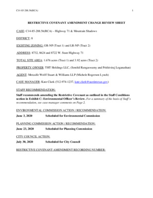
C14-85-288.56(RCA) 1 RESTRICTIVE COVENANT AMENDMENT CHANGE REVIEW SHEET CASE: C14-85-288.56(RCA) – Highway 71 & Mountain Shadows DISTRICT: 8 EXISTING ZONING: GR-NP (Tract 1) and LR-NP (Tract 2) ADDRESS: 8732, 8624 and 8722 W. State Highway 71 TOTAL SITE AREA: 1.676 acres (Tract 1) and 3.92 acres (Tract 2) PROPERTY OWNER: THT Holdings LLC, (Senthil Rangaswamy and Prithiviraj Loganathan) AGENT: Metcalfe Wolff Stuart & Williams LLP (Michele Rogerson Lynch) CASE MANAGER: Kate Clark (512-974-1237, kate.clark@austintexas.gov) STAFF RECOMMENDATION: Staff recommends amending the Restrictive Covenant as outlined in the Staff Conditions section in Exhibit C: Environmental Officer’s Review. For a summary of the basis of Staff’s recommendation, see case manager comments on Page 2. ENVIRONMENTAL COMMISSION ACTION / RECOMMENDATION: June 3, 2020 Scheduled for Environmental Commission PLANNING COMMISSION ACTION / RECOMMENDATION: June 23, 2020 Scheduled for Planning Commission CITY COUNCIL ACTION: July 30, 2020 Scheduled for City Council RESTRICTIVE COVENANT AMENDMENT RECORDING NUMBER: C14-85-288.56(RCA) 2 ISSUES Neighbors in the area are concerned about the project connecting to Mountain Shadows Drive per the current Restrictive Covenant (RC) requirements. Because this project site is over the Barton Springs Contributing Zone, the Applicant, the Austin Transportation Department (ATD) and the Office of the Environmental Officer have been working closely to come to an agreement on how and when this road should be developed. Mountain Shadows Drive is shown on the Austin Strategic Mobility Plan (ASMP) to be extended from its current terminus to State Highway 71. At this time, ATD is recommending removing the current language in the RC and to defer ROW dedication for this road until submittal of the first subdivision or site plan application. The Applicant has agreed to not take access to any of the existing neighborhood roads for this development project. Therefore, they will be constructing a part of Mountain Shadows Drive from State Highway 71 to their project entrance for their access. They have agreed to only build the portion of the road that will be necessary to provide access for their development and dedicate the remaining ROW to be constructed at a later date. CASE MANAGER COMMENTS: The proposed Restrictive Covenant Amendment (RCA) area is approximately 5.596 acres and is currently undeveloped. It was zoned to GR and LR in 1987. The zoning case included a public Restrictive Covenant (RC) that dictated development standards and permitted land uses for these tracts of land. The applicant is requesting to amend C14-85-288.56 RC (see Exhibit B: Original 1985 Restrictive Covenant) to keep the existing impervious cover allowances, increase the originally allowed maximum FAR to current code and to allow various types of construction on different slope types (current code) in exchange of relinquishing outdated Environmental Codes. BASIS OF RECOMMENDATION: Staff recommends the proposed amendments to the RC because much of it allows for development under a previous code and therefore is not up to date on newer and current standards. Please refer to the “Staff Conditions” section within Exhibit C: Environmental Officer’s Review for Staff’s Recommendations on the amendments to the RC. EXISTING ZONING AND LAND USES: Zoning Land Uses LR-NP and GR-NP Undeveloped RR-NP Undeveloped Site North South Right-of-way and PUD-NP State Highway 71 and multifamily residential C14-85-288.56(RCA) 3 East West GR-NP AG-NP Zoning Land Uses Fire station and government buildings Single family residential NEIGHBORHOOD PLANNING AREA: Oak Hill Combined Neighborhood Plan (West Oak Hill, NP Ordinance No. 20081211-096) TIA: not required at this time. WATERSHED: Williamson Creek (Barton Springs Zone -Contributing Zone) OVERLAYS: Barton Springs Overlay SCHOOLS: Oak Hill Elementary, Small Middle and Austin High Schools NEIGHBORHOOD ORGANIZATIONS Austin Independent School District Aviara HOA Bike Austin City of Rollingwood Covered Bridge Property Owners Friends of Austin Neighborhoods Neighborhood Empowerment Foundation Oak Hill Association of Neighborhoods (OHAN) AREA CASE HISTORIES: Oak Hill Neighborhood Plan - COA Liaison Oak Hill Neighborhood Plan Contact Team Oak Hill Trails Association Ridgeview Save Our Springs Alliance SELTexas Sierra Club, Austin Regional Group Thomas Springs Alliance TNR BCP - Travis County Natural Resource Number Request Commission City Council C14-2011-0038 RR-NP to MF-1-NP To grant MF-1-CO- NP as staff recommended. CO was to limit trips per day. To approve MF-1- CO-NP as Commission recommended. (8/18/11) Mountain Shadows Rezone, Lots K, L and P 8800 Sky Mountain Drive C14-85-288.56(RCA) 4 Number Request Commission City Council C14-00-2104 I-RR and RR to Oak Forest MF-1-CO 8501-8635 Block of Old Bee Caves Rd C14-85-288.115 RR to MF-1 Mountain Shadow's Subdivision To grant MF-1-CO as staff recommended. CO was to limit trips per day, prohibit access to Mountain Crest Drive and Sky Mountain Drive and a dedication of ROW. To grant MF-1 as staff recommended with public restrictive covenant. To approve MF-1-CO as Commission recommended. (11/30/00) To Approve MF-1 as Commission recommended with public restrictive covenant. (4/30/87) RELATED CASES: C14-2020-0023: This rezoning case is currently being reviewed and includes the area that is covered by this Restrictive Covenant (RC) as well as additional land to the northeast. For the area that is covered by this RC, the Applicant is requesting to rezone from LR-NP and GR-NP to LR-MU-MP. C14-2008-0125: West Oak Hill NPCD Oak Hill Combined Neighborhood Plan (Ordinance No. 20081211-097) EXISTING STREET CHARACTERISTICS: Street ROW Pavement Classification Sidewalks 50’ 20’ Level 2 None Capital Metro (within ¼ mile) Bike Route None None 150’ 75’ Level 5 None None None Mountain Shadows Drive W SH 71 OTHER STAFF COMMENTS: Transportation The Austin Transportation Department (ATD) staff recommends removing language regarding the dedication on Mountain Shadows or the replacing existing text with the following alternative: “Mountain Shadows Road shall comply with the Austin Strategic Mobility Plan”. C14-85-288.56(RCA) 5 Environmental Officer Please refer to Exhibit C: Environmental Officer’s Review. INDEX OF EXHIBITS TO FOLLOW Exhibit A: Restrictive Covenant Amendment Map Exhibit B: Original 1985 Restrictive Covenant Exhibit C: Environmental Officer’s Review ( C14-02-0164 MF-1-CO-NP ( R L D L E B SP92-306C CS-NP ( 85-288.139RC LR-MU-CO-NP ( = C14-2015-0020 C14-2012-0024 NPA-2012-0025.03 ( RR-NP WHSE C14-04-0038 C14-06-0067 ( SP-03-0223C M O U N WHSE NPA-2014-0025.01 WHSE C14-01-0129 W/LO-CO-NP TAIN C R E S T D R ( ELECTRIC SUPPLY CS-NP ( 85-288.37RC UNDEV 85-288.C AG-NP UNDEV ( RR-NP 85-288.F UNDEV ( ( ( R RR-NP S D ( W O D A H MF-1-NP = TAIN S N U O M UNDEV 2011-0038 C14-2011-0038 MF-1-NP ( UNDEV SK Y M O U NTAIN D R ( ! ! ! RR-NP ( M O U N TAIN S ( = = H A D O W MF-1-NP = ( MF-1-NP 85-170RC ( ( ( S C V = ! ! ! ! ! ! ! LR-NP ! ! ! ! ! NPA-2016-0025.02 ! ! ! ! ! ! ! ! ! ! ! W S H 71 ! ! ! SP-98-0081C SP-98-0197C GR-NP SP-98-0197C(XT3) 85-288.P UNDEV MF-1-CO-NP C14-00-2104 SP-2007-0442C MF-1-NP LO-NP UNDEV PUD-NP C814-2007-0009.02 C814-2007-0009 C814-2007-0009.01 NPA-2012-0025.02 FIRE STATION 85-288.118RC NPA-2011-0025.04 85-288.45RC C14-98-0223 C14-85-288.45(RCA2) C814-2012-0055.01 C814-2012-0055.02 C814-2012-0055 PUD-NP SP-05-1513C 85-288.45RC C814-2012-0055(RCA) NPA-2011-0025.01 C14-85-288.45 85-288.45RC SP-05-1236C MF-1-NP SP-03-0530C UNDEV MF-1-NP SF-2-CO-NP C14-2007-0065 MF-1-CO-NP C14-2017-0019 C14-04-0071 RR-NP Restrictive Covenant Amendment CASE#: C14-85-288.56(RCA) SF-6-NP ± SUBJECT TRACT ! ! ! ! ! ! PENDING CASE ZONING BOUNDARY This product is for informational purposes and may not have been prepared for or be suitable for legal, engineering, or surveying purposes. It does not represent an on-the-ground survey and represents only the approximate relative location of property boundaries. 1 " = 400 ' This product has been produced by CTM for the sole purpose of geographic reference. No warranty is made by the City of Austin regarding specific accuracy or completeness. Created: 2/19/2020 ~, . . . ' .. ·. zoning case No. Cl4-es-2ea, 56 ,:: , RESTRICTIVE COVENANT owner: LHC Joint Venture 4 28 5385 Owner's Address: P, 0. Bo>t 2i02- Austin, Texas 7876~& consider~tion: one and No/100 Do1lars ($1.00) and other good and valuable consideration paid by the City ot Austin to the owner, the receipt and sufficiency of which is acknowledged. \ Property: Tract l: All that certain tract, piece or parcel of land, lying and being situated in ~he County in of Travis, Stata of Texas, described EXhibit 11A11 attached hereto and made a· part hereof for all purposes, to which reference is hare made tor a more particular descrii.- tion of said property; and . •' '.!'. ... ' Tract 2: All that certain tract, ·piece · or parcel of land, lying and being situated in the ~unty of Travis, State of Texas, described in Exhibit llB" attached hereto and made a part hereof for all purposes, to which reference is hare ~ade for a more particular descrip- tion of said property. , owner of the Prop&rty, for the consideration, impresses the Property with these covenants ,and restrictions ruMing with the land: 1. The following covenants and restrictions apply only to Tract 1 cL the Property: a) b} C) d) e) f) Maximum impervious coverage of ths Property shall be 65 percent. The Property shall be li•ited to a maximum of ,20 to 1 floor to area ratio ·as de~ined by Section 1212 of Chapter 13-2A of the AUGtin City Code. Development of the Property shall be in compliance with sections 9-10-171 through 9-10-230 and Sections 13-3• 401 through 13-3-475 of the Austin City Code of 1981 except for thei following sections: . 'l'ha pa.rt ot section 9-10-191 which reads "or to a development within a recorded subdivision which was finally approved or finally disapproved by the Planning commission prior to December 18, 1980," Section 9-10-20&, aubseotiona (o), (d), and (e) ; Section 13-3-408(a) Section 13-3-433, subsections (c), (d), and (e), The gaximum numb~r of curb cuts on the Property where "it fronts state Highway 71 ( 118.H. 1111 ) ahal~ be one. . . .... ~ The Property shall · be lbaitad to Restaurant. (General) and Restaurant (Drive-rn, Fa•t Fo0d) usaa · as 0derined. in Bectiona 1725 and 1721 in Chapter 13-2A o~ the Aus.tln City Code. If use of the Property as a restaurant is discontinued ~or 90 cona•cutive days, the owner . of the Property will not object to tha city of Austin rezoning the Property to 11LR11 Neighborhood Colmllercial as defined in Sections 2415 through 2479 ot the Auatin city code. Normal, seaaonal ~essation ot a use, or t•mporary- diacon tinuance purposes of maintenance or reb~ilding of the . • j.< ., ;• I ' ... ' i .. . -, , . ,•. . ' . •,, ::~ .... . ,, ,. i', REAL PROPERTY RECORDS Travis County, Te>.ils l 10433 ·o I· 75 .. Property after da~age or destruction shall not be included in calculating the period of discontinuance. 2. The following covenants and restrictions apply only to Tract 2 of the Property: a) b) c) Maximum impervious coverage ot the Property shall be 65 percent, The Property shall be limited to a ~aximun of .20 to l floor to area ratio as defined by section 1212 of Chapter l3-2A of the Austin City Code. Development of the Property shall be in compliance with Sections 9-10-171 through 9-10-230 and Sections 13-3- through 13-3-475 of the Austin City code of 1981 401 except for the following sections: The part ·of Section 9-10-l.91 which reads "or to a development within a reoordacl subdivision 'Which was finally approved. or finally disapproved by the ~lanning CoJDmieaion prior to December 18, 1980, 11• Section 9-10-208, ·aubaections (c), (d), and (a). Section 13-3-408 (a) Section ll-3-433, sUbaectiona (c), (d), and (e). · d) A building permit for the site on this tract ahail not be i·ssued until Mountain Shadowa Road has .been con structed from state Highway 71. to "the north Property line at 44 feet of pavement within 70 feet of right-of way, or at a design standard as otherwise may be approved by the City. 3 • 4. 5. 6. If any parson or entity shall violate or attempt to violate this agreement and covenant, it shall be lawful for the City of Austin, a municipal corporation, its successors and assigns, to .prosecute proceedings ·at law or in equity, against such person or entity violating or attempting to violate such agreement or covenant, to prevent the person or entity from such actions, and to collect damages for such actions. If any part of this agreement or covenant shall be declared invalid, by judgment or court order, the same shall in no way affect any, of the other provisions of this agreement, and such remaining portion of this agreement shall remain in full effect. If at any time the City of Austin, ita auccesaors or assigns, fails to enforce this agreement, whether or not any violations of it are known, such failure shall :iot constitute a waive.r or estoppal of the right to enforce it. This agreement may be modified, amended, or teDinatad only by joint action of both (a) a majority of the membera of the City Council of the city of Austin, or such other governing body aa ~ay succeed the City council of the City of Austin, and (b) by the owner(s) of the Property at the tise of auch modification, amendment or termination. All citations to the Austin City .Code shall refer to the Austin City Code ot 1981, as amended from ti111e to time, unless otherwise specified. ~'hen the context reguires, singular nouns and pronouns include the plural. - ' 2 lr0-433 0-,116 EXECUTED thi_s ___ ___._lo ..... _h ___ day of _...;aLLLY"'-"j1,..:l"-'f5.,_t~--· 1987 J.IIC JOINT VENTURE THE STATE OF TEXAS This i nstrwnent was ac:knowledeg before me on ) ()-th , 1987, by Hubert M. Caskey, managing partner, on behalf of 0,, u_g U 5 ± LIIC Joint Venture, n joint venture • .-9 ---=:V~f!t1..:....:..~"'-'---ii ./).~ r Nor1fir. SE.A£ I L/J . ..ir~,((~c.«., __ ____..~ IL Notary Publie, State of Texas Notary's na111e (printed Bambi G. Slack Notary's colDIQi&sion expires: May 3, 1988 8528856.RC 110(;3-3 MEMORANDUM May 20, 2020 Linda Guerrero, Chair, and Members of the Environmental Commission Christopher S. Herrington, P.E., Environmental Officer Watershed Protection Department TO: FROM: DATE: SUBJECT: Highway 71 & Mountain Shadow RCA – C14-85-288.56(RCA) This summary is being provided to the Environmental Commission for the Highway 71 & Mountain Shadow Restricted Covenant Amendment (RCA), a proposed amendment to an existing restrictive covenant from 1985. History Restrictive covenants from this time period are legal documents that establish site development regulations and use limitations for some properties located within the Oak Hill Study area. These restrictive covenants establish certain entitlements for the land which may accompany restrictions on allowable or prohibited land uses. This restrictive covenant includes two tracts of land which are located in the full purpose jurisdiction, in the Williamson Creek Watershed, and in the Contributing Zone of the Barton Springs Segment of the Edwards Aquifer: Tract 1 - 1.676 acres Tract 2 – 3.92 acres These Oak Hill area restrictive covenants frequently lock in older site development regulations which predate current water quality protections for the Barton Springs Zone established by City Code 25-8, Article 13 (Save Our Springs Initiative). These properties could develop under the terms of the restrictive covenant without achieving compliance with the non-degradation water quality standard of the Save Our Springs Ordinance. If the property is rezoned to allow uses other than the uses allowed by the restrictive covenant, the restrictive covenant must also be amended. Because these restrictive covenants entitle the properties to develop under older regulations, amending these restrictive covenants provides an opportunity for additional environmental protection and for development on these tracts to achieve a greater degree of compliance with current environmental regulations. 1 Proposed Changes The applicant is proposing to rezone the property from LR-NP, RR-NP, GR-NP to MF-1-NP and LR-MU-NP. As part of the restrictive covenant amendment, the applicant is agreeing to also amend the terms of the restrictive covenant to provide additional environmental benefits, in particular agreeing to comply with the non-degradation water quality treatment standard of the Save Our Springs Ordinance. Staff Recommendation Because the restrictive covenant amendment provides greater overall environmental protection and achieves a higher degree of overall compliance with current regulations than would otherwise be permitted under the current restrictive covenant, staff recommends this restrictive covenant amendment with conditions. Staff Conditions 1. This application completes the project established by the Restrictive Covenant such that any further development or redevelopment is subject to current code at the time of site development permit application. 2. This project shall comply with current code except for the following exceptions: a. 65% impervious cover on a gross site area shall be allowed for Tracts 1 and 2 as established by the current Restrictive Covenant. b. A 1.25 acre area of Tract 2 shall comply with the Code of 1985 (Rivers, Lakes, and Watercourses) section 9-10-192(g) for construction on slopes as established by the current Restrictive Covenant. The remainder of Tract 2 shall comply with current code for construction on slopes. c. Cut and fill shall not exceed 8 feet for a 1.25 acre area of Tract 2. The remainder of Tract 2 shall comply with current code for cut and fill. 3. All impervious cover shall be treated for water quality under the non-degradation standards of the Save Our Springs Initiative, City Code 25-8, Article 13 (Save Our Springs Initiative), including sizing water quality treatment volumes to account for the future extension of Mountain Shadows Road. 4. The Mountain Shadows Road right-of-way shall be included in the calculation of allowable impervious cover. to be located on Tract 1. 5. A water quality control for the treatment of development on Tracts 1 and 2 shall be allowed 6. Restrictions on curb cuts along State Highway 71 for Tract 1 established by the current Restrictive Covenant shall be removed, as access to State Highway 71 is determined by the Texas Department of Transportation. 7. The restrictions on issuance of building permits for Tract 2 contingent upon construction of Mountain Shadows Road in the current Restrictive Covenant shall be modified to provide for a safer connection to the existing roadway as determined by the Austin Transportation Department using current code requirements. If you have any questions about the environmental conditions of this restrictive covenant amendment, please contact Atha Phillips in the Watershed Protection Department at 512-974- 2132 or atha.phillips@austintexas.gov. 2 Hwy 71 & Mountain Shadows Restrictive Covenant Amendment • Williamson Creek Watershed • Barton Springs Zone • Edwards Aquifer Contributing Zone • Current Code: 25% Net Site Area Impervious Cover Entitled Impervious Cover: 65% Gross Site Area • Will provide SOS non-degradation water quality