20200520-006a: Additional 300K Ground Water Storage Tank Improvements 360 SP-2019-0417D variance packet — original pdf
Backup
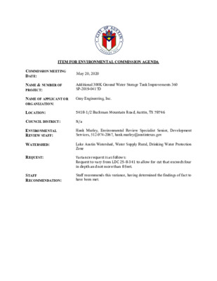
ITEM FOR ENVIRONMENTAL COMMISSION AGENDA COMMISSION MEETING DATE: May 20, 2020 NAME & NUMBER OF PROJECT: Additional 300K Ground Water Storage Tank Improvements 360 SP-2019-0417D NAME OF APPLICANT OR ORGANIZATION: Gray Engineering, Inc. LOCATION: 5418-1/2 Buckman Mountain Road, Austin, TX 78746 COUNCIL DISTRICT: N/a ENVIRONMENTAL REVIEW STAFF: WATERSHED: REQUEST: Hank Marley, Environmental Review Specialist Senior, Development Services, 512-974-2067, hank.marley@austintexas.gov Lake Austin Watershed, Water Supply Rural, Drinking Water Protection Zone Variance request is as follows: Request to vary from LDC 25-8-341 to allow for cut that exceeds four in depth and not more than 8 feet. STAFF RECOMMENDATION: Staff recommends this variance, having determined the findings of fact to have been met. Development Services Department Staff Recommendations Concerning Required Findings Project Name: SP-2019-0417D Additional 300K Ground Water Storage Tank Improvements 360 Ordinance Standard: Watershed Protection Ordinance Variance Request: For cut (LDC 25-8-341) exceeding 4 feet in depth in the Drinking Water Protection Zone Include an explanation with each applicable finding of fact. A. Land Use Commission variance determinations from Chapter 25-8-41 of the City Code: 1. The requirement will deprive the applicant of a privilege available to owners of similarly situated property with approximately contemporaneous development subject to similar code requirements. Yes Many water supply corporations, municipal utility districts and public utility districts in the area are obligated to expand water storage capacity to meet the needs of their customer base in a known geographical region that they are mandated by the state to service. Therefore, not granting the variance would deprive the owner a privilege available to owners of similarly situated properties. 2. The variance: a) Is not necessitated by the scale, layout, construction method, or other design decision made by the applicant, unless the design decision provides greater overall environmental protection than is achievable without the variance; Yes The Loop 360 Water Supply Corporation is required to provide an additional 300,000 gallons of storage to its customers. The proposed water storage tank is designed to be connected to and support the existing tank that sits on the adjacent easement. The adjacent tank has an overflow elevation of 870 feet. Therefore, the proposed tank will also have an overflow elevation of 870 feet as it will be filled simultaneously by the same water pumps used for the existing tank. The cut in excess of four feet is needed so that the required 300,000 gallons of water storage is contained under the 870 foot elevation. In addition, the footprint of the tank cannot be expanded because the tank must be designed to fit within the allotted easement. Within this easement, there is also surface area required to provide a sidewalk / concrete trickle channel to convey overflow drainage towards the pond and an earthen berm that will prevent off-site surface water flows onto the site. Furthermore, the allotted easement cannot be expanded as there are two existing guy wire anchors for the communication tower immediately adjacent to the west of the project site. Options to adjust the location or configuration of the proposed tank are infeasible based on the site characteristics unique to this property and based on the required design specifications for the proposed tank. See Staff Exhibit 1 – Proposed Site Plan. Is the minimum deviation from the code requirement necessary to allow a reasonable use of the property; Yes Since a minimum of 300,000 gallons are required to meet the demands of the water supply corporations customer base during peak flow and be able to contain that storage capacity under an overflow elevation of 870 feet, then a cut that exceeds 4 feet in depth below the water tank is required. The maximum depth of cut required is no more than 5.5 feet. Also, the area within the allotted easement must be designed to include a required water quality pond to treat onsite flows and provide a required hammer head turn-around. Thus, minimizing surface area to be used to widen the water storage tank. Therefore, the variance is the minimum deviation from the code requirement necessary to allow a reasonable use of the property. Does not create a significant probability of harmful environmental consequences. Yes A retaining wall to ensure slope stability has been designed at the location of the cut exceeding four feet. Furthermore, the proposed project has been designed to preserve as many trees as possible, even though the site is entirely within the City’s Extra Territorial Jurisdiction (ETJ); where City code does not extend tree preservation requirements. Without the variance these trees could not be preserved. Therefore, the variance would not create a significant probability of harmful environmental consequences. b) c) 3. Development with the variance will result in water quality that is at least equal to the water quality achievable without the variance. Yes In order to meet City code requirements, the proposed development is designed to include the construction of a water quality pond in the form of a bio filtration basin. Due to spacing constraints within the allotted easement, without the variance the water quality pond would not be feasible. B. The Land Use Commission may grant a variance from a requirement of Section 25-8-422 (Water Supply Suburban Water Quality Transition Zone), Section 25-8-452 (Water Supply Rural Water Quality Transition Zone), Section 25-8-482 (Barton Springs Zone Water Quality Transition Zone), Section 25-8-368 (Restrictions on Development Impacting Lake Austin, Lady Bird Lake, and Lake Walter E. Long), or Article 7, Division 1 ( Critical Water Quality Zone Restrictions ), after determining that:: 1. The criteria for granting a variance in Subsection (A) are met; 2. 3. N/a N/a N/a The requirement for which a variance is requested prevents a reasonable, economic use of the entire property; The variance is the minimum deviation from the code requirement necessary to allow a reasonable, economic use of the entire property. Staff Determination: Staff determines that the findings of fact have been met. Staff recommends the following conditions: 1. Preserve the following trees next to the hammer head turnaround the water quality pond and the water tank: #524 Cedar; #525 Cedar; #526 Cedar; #527 Cedar and #534Cedar. 2. Re-vegetate all disturbed areas including the staging and storage area near the Buckman Mountain Road with City Standard Specification 604S.6 Native Grass and Forb Seeding. Environmental Reviewer (DSD) ___________ __________________ Hank Marley Date 5/5/2020 Environmental Review Manager (DSD) _____________________________ Mike McDougal Date 5/3/2020 Environmental Officer (WPD) ____________________________ Chris Herrington, P.E. Date 05/05/2020 Hank Marley Staff Exhibit 1 – Proposed Site Plan ENVIRONMENTAL COMMISSION VARIANCE APPLICATION FORM January 21, 2020 PROJECT DESCRIPTION Applicant Contact Information Variance Case Information Name of Applicant Street Address City State ZIP Code Work Phone E-Mail Address Case Name Case Number Address or Location Environmental Reviewer Name Environmental Resource Management Reviewer Name Applicable Ordinance Watershed Name Watershed Classification ☐Urban ☐ Suburban ☐Water Supply Suburban ☐Water Supply Rural ☐ Barton Springs Zone City of Austin | Environmental Commission Variance Application Guide 1 David Gray, P.E.512-452-0371Austin, TX 78759dwg@grayengineeringinc.com 8834 North Capital of Texas Highway, Suite 140Additional 300K Ground Water Storage Tank Improvements 360SP-2019-0417D5318 1/2 BUCKMAN MOUNTAIN ROADHank MarleyLake Austin WatershedLDC 25-8-341February 20, 2020 Edwards Aquifer Recharge Zone ☐ Barton Springs Segment ☐ Northern Edwards Segment ☐ Not in Edwards Aquifer Zones ☐ Yes ☐ No Edwards Aquifer Contributing Zone Distance to Nearest Classified Waterway Water and Waste Water service to be provided by The variance request is as follows (Cite code references: Existing ________ ________ ________ Proposed _________ _________ _________ January 21, 2020 Request Impervious cover square footage: acreage: percentage: Provide general description of the property (slope range, elevation range, summary of vegetation / trees, summary of the geology, CWQZ, WQTZ, CEFs, floodplain, heritage trees, any other notable or outstanding characteristics of the property) City of Austin | Environmental Commission Variance Application Guide 2 .05 ACRES2173.96 SF7333.99 SF (ADDITIONAL)0.168 ACRES (ADDITIONAL)0.213 ACRES (TOTAL)1.154% OF NET SITE AREA5.05% OF NET SITE AREA (TOTAL)5,750 FT (LAKE AUSTIN)The site is within the 10.013 lot 11 of the Mary Jane Lee Subdivision. Improvements will occur inside a 0.334 Acre"Water Tank Easement" (DOC NO. 2019059274 OPRTCT) within this property. Slopes within the water tankeasement range from 0% - 40%. Slopes within the whole property range from 0% - 70%. There are trees over 8"within this easement, listed on the Erosion Control Sheet of the construction plans. 8 Trees are proposed to beremoved with this development, none of which are heritage trees. Elevations within the developable easementrange from 846.00 to 860.75 sloping downward from North to South. The property is not in the 100 year floodplain,CWQZ, or WQTZ. February 20, 2020 January 21, 2020 City of Austin | Environmental Commission Variance Application Guide 3 FINDINGS OF FACT As required in LDC Section 25-8-41, in order to grant a variance the Land Use Commission must make the following findings of fact: Include an explanation with each applicable finding of fact. Project: Ordinance: A. Land Use Commission variance determinations from Chapter 25-8-41 of the City Code: 1. The requirement will deprive the applicant of a privilege available to owners of similarly situated property with approximately contemporaneous development subject to similar code requirements. Yes / No [provide summary of justification for determination] 2. The variance: a) Is not necessitated by the scale, layout, construction method, or other design decision made by the applicant, unless the design decision provides greater overall environmental protection than is achievable without the variance; Yes / No [provide summary of justification for determination] February 20, 2020The construction of the proposed tank with the required storage capacity, location, and overflow elevation would not be possiblewithout exceeding 4' of cut. See explanation for this in section 2a) below. The adjacent property is subject to similar coderequirements and has an identical ground water storage tank with greater capacity (400,000 gallon). The cut depth in excess of 4 feet is necessary to meet the required volume of the tank (300,000 gallons). This is the additional storage capacity required for Loop 360 WaterSupply Corporation to provide to its customers. The reason the tank cannot be placed at a higher elevation is that the tank has a required overflow elevation of 870'. All waterstorage tanks must have an overflow elevation. The overflow elevation provides relief of excess water if the pumps filling the tank malfunction and do not turn off when they aresupposed to. The overflow elevation of this tank is required to be 870' because it will be filled simultaneously with the existing tank. Even if the new tank's overflow elevationwas above 870', it will still be unable to fill up over 870' because it will be connected to the existing tank. Therefore the overflow elevation, and all 300,000 gallons of requiredstorage capacity must be under the 870' elevation. The footprint of the tank can not be increased to achieve this required volume, because it is required due to spacing constraints. The tank, walls and channel around thetank, berms, water quality rain garden, and drive must all be within the water tank easement (Doc No. 2019059274 OPRTCT). Furthermore there are two existing guy wireanchors for the nearby communications tower to the west of the easement that make it impossible to have the tank located any further west. Since the tank footprint, location, overflow elevation, and volume are required, the depth of the tank is also required, and thus cut in excess of 4 feet is required. The position and elevation of the pond is also required because it needs to accept flows from the site, while providing the required water quality volume, and being able tooutflow at the proper location. Also note that all cut over 4 feet within the rain garden will be filled with biofiltration media, as part of the requirements for a rain garden. The smaller footprint of the tank achieved with the required depth also provides greater environmental protection. The smaller footprint reduces increase in impervious cover,minimizes impact to existing grade, and reduces the number of trees needed to be removed. With extra depth of cut in the pond, the footprint of the pond is also reduced. This also minimizes impact to existing grade and reduces the number of trees needed to beremoved. Also note that City Arborist Taylor Horton has accepted that “all design alternatives which could save trees have been evaluated,” and that our plan presents the best optionfor preserving the most trees. Clearly indicate in what way the proposed project does not comply with current Code (include maps and exhibits) LDC 25-8-341 states that cut may not exceed 4 feet of depth. Due to the requiredlocation and overflow elevation of the proposed tank and associated water quality raingarden, a cut of up to 5.259 feet is required. See Exhibit A - Variance Request Letterfor further explanation. EXHIBIT F - APPROVED ERIEXHIBIT G - TOPOGRAPHIC/SLOPE MAPEXHIBIT H - CONSTRUCTION PLAN SETEXHIBIT A - VARIANCE REQUEST LETTEREXHIBIT B - AERIAL MAPSEXHIBIT C - SITE PHOTOSEXHIBIT D - CONTEXT MAPEXHIBIT E - CUT/FILL GRADING EXHIBIT January 21, 2020 City of Austin | Environmental Commission Variance Application Guide 4 February 20, 2020c) Does not create a significant probability of harmful environmental consequences. Yes / No [provide summary justification for determination] 3. Development with the variance will result in water quality that is at least equal to the water quality achievable without the variance. Yes / No [provide summary justification for determination] B. Additional Land Use Commission variance determinations for a requirement of Section 25-8-422 (Water Quality Transition Zone), Section 25-8-452 (Water Quality Transition Zone), Article 7, Division 1 (Critical Water Quality Zone Restrictions), or Section 25-8-368 (Restrictions on Development Impacting Lake Austin, Lady Bird Lake, and Lake Walter E. Long): 1. The criteria for granting a variance in Subsection (A) are met; Yes / No [provide summary of justification for determination] 2. The requirement for which a variance is requested prevents a reasonable, economic use of the entire property; Yes / No [provide summary of justification for determination] 3. The variance is the minimum deviation from the code requirement necessary to allow a reasonable, economic use of the entire property. Yes / No [provide summary of justification for determination] **Variance approval requires all above affirmative findings. A wall has been proposed behind the tank, at the location of cut exceeding 4 feet. This wall has been designed bya structural engineer to ensure slope stability behind the wall. Walls in the pond are under 3', and the proposedmaximum grading other than the walls is 3:1. Therefore there is not a "significant probability of environmental harmat these locations." The variance allows for the preservation of several trees, which would not be possible withoutthe variance.A water quality rain garden is being constructed along with storage tank. The rain garden has been designed tomeet City of Austin water quality requirements (ECM Appendix R-11). This can be seen on the Pond Plan sheet inthe attached construction plans (Exhibit H). Also, the minimal cut over 4 feet will not effect water quality comparedto the water quality achievable without the variance.This project is not in the water quality transition zone, or in the critical water quality zone. All requirements insubchapter (A) have been met except 25-8-341, which is the section we are requesting a variance. The subchapter(A), section 25-8-41 criteria for granting a variance have been met, as explained in part A section 1,2, and 3 above.This tank will allow Loop 360 Water Supply Corporation to provide additional water storage capacity to it'scustomers. This is a reasonable and necessary use for this property. Without this variance construction of the tankwith the required storage capacity, location, and overflow elevation would not be possible. Design of the raingarden to meet ECM appendix R-11 requirements, while preserving as many trees (8" and larger) as possible,would also not be possible.This tank will allow Loop 360 Water Supply Corporation to provide additional water storage capacity to it'scustomers. This is a reasonable and necessary use for this property. For construction of the water storage tank,and water quality rain garden, the minimum necessary deviation from the code has been taken. Construction of thetank requires cut of up to 5.259 feet, while construction of the rain garden requires cut of up to 5.13 feet. Providingthe necessary water tank storage capacity and water quality controls, while preserving as many trees as possible,would not be possible without this minimum deviation from the code. Note that all cut over 4 feet within the raingarden will be filled with biofiltration media. b) Is the minimum deviation from the code requirement necessary to allow a reasonable use of the property; Yes / No [provide summary justification for determination] This tank will allow Loop 360 Water Supply Corporation to provide additional water storage capacity to it'scustomers. This is a reasonable and necessary use for this property. For construction of the water storage tank,and water quality rain garden, the minimum necessary deviation from the code has been taken. Construction of thetank requires cut of up to 5.259 feet, while construction of the rain garden requires cut of up to 5.13 feet. Thereasons for this are explained in section 2a) above. Providing the necessary water tank storage capacity and waterquality controls, while preserving as many trees as possible, would not be possible without this minimum deviationfrom the code. Note that all cut over 4 feet within the rain garden will be filled with biofiltration media. January 21, 2020 A Exhibits for Commission Variance o Aerial photos of the site o Site photos o Aerial photos of the vicinity o Context Map—A map illustrating the subject property in relation to developments in the vicinity to include nearby major streets and waterways o Topographic Map - A topographic map is recommended if a significant grade change on the subject site exists or if there is a significant difference in grade in relation to adjacent properties. o For cut/fill variances, a plan sheet showing areas and depth of cut/fill with topographic elevations. o Site plan showing existing conditions if development exists currently on the property o Proposed Site Plan- full size electronic or at least legible 11x17 showing proposed development, include tree survey if required as part of site or subdivision plan o Environmental Map – A map that shows pertinent features including Floodplain, CWQZ, WQTZ, CEFs, Setbacks, Recharge Zone, etc. o An Environmental Resource Inventory pursuant to ECM 1.3.0 (if required by 25-8-121) o Applicant’s variance request letter City of Austin | Environmental Commission Variance Application Guide 5 February 20, 2020 EXHIBIT B - AERIAL MAP SHEET 1 OF 2 L L E N L . D 5 U A S C . 3 & 1 E S E 4 , P R . P . R . T . C . T . U L S . & S 0 A 9 . 0 S 1 T E L N 2 L . 1 L Y J V O A O 1 4 1 N D I V I S I O B G . 1 6 4 5 E A H M I C R M A N D I V I S I O 7 6 3 B T 1 U E S O G . 5 E E L 7 , P D . R . T . C . T . L . 3 L N O Y J R A V M A LOT 14 MARY JANE LEE SUBDIVISION VOL. 37, PG. 567 D.R.T.C.T. MICHAEL S. & SUSAN L. DELL 14.21 AC. DOC. NO. 2002245956 O.P.R.T.C.T. SCALE: 1"=60' GRAPHIC SCALE IN FEET 0 30 60 90 120 e r 2 b 9 m 2 u y N e r 3 b e u r v u m y S c t N s G r a s tr a b m a A o h T SITE X X W W X CONC. WALL CONC. WALL LOT 11 MARY JANE LEE SUBDIVISION VOL. 37, PG. 567 D.R.T.C.T. WATER TANK EASEMENT DOC NO. 2019059274 OPRTCT X E X I S T I N G C O N C . G U Y W I R E A N C H O R S X X TEMPORARY CONSTRUCTION EASEMENT DOC NO. 2019059274 OPRTCT X W W W W W W EXISTIN G 12" W ATER LINE EXISTING 8" W ATER LINE W W LOOP 360 WATER SUPPLY CORPORATION ACCESS EASEMENT DOC NO. 2019081185 OPRTCT X X EXISTING LOOP 360 WATER SUPPLY CORPORATION WATER STORAGE TANK EASEMENT VOL. 9084, PG. 728 R.P.R.T.C.T. X LOT 12 MARY JANE LEE SUBDIVISION VOL. 37, PG. 567 D.R.T.C.T. OUTLET EXISTING ROCK BERM OUTLET EXISTING METAL TANK ON CONCRETE PAD W W X I I " 8 G N T S X E E N L R E T A W I W W I E N L R E T A W " 2 1 G N T S X E I I T L A H P S A G N T S X E I I I E V R D W Y E K D A P ALARM PANEL W W X TEMPORARY CONSTRUCTION EASEMENT DOC NO. 2019059274 OPRTCT MICHAEL & SUSAN DELL 4.717 AC. VOL. 12008, PG. 1955 R.P.R.T.C.T. WATER TANK EASEMENT DOC NO. 2019059274 OPRTCT (N 29°37'39" E 254.54') N 27°44'25" E 254.45' (N 29°28'11" E 253.90') N 27°38'07" E 253.78' ) ' 0 5 . 2 5 1 E " 3 4 4 3 ° 9 2 N ' ( ' 5 5 . 2 5 1 E " 3 5 2 4 ° 7 2 N ' N W O D E P O L S X X (N 30°00'00" E 355.80') N 27°42'21" E 355.86' ACCESS EASEMENT TRACT A1 DOC NO. 2019059177 OPRTCT . C N O C D E N O D N A B A E S A B E R W Y U G I . P . L , S A X E T F O N O S V E L E T N I L I I E N O L E C R A P , I E V F T C A R T " I I I N O S V D B U S E E L E N A J Y R A M ) . C A 9 8 . 1 D E L L A C ( . C A 9 8 . 8 1 1 1 & 9 S T O L F O L L A " 2 6 2 . G P , 3 5 4 2 1 . L O V . . . . T C T R P R . . CITY OF AUSTIN ELECTRIC UTILITY EASEMENT 0.1205 AC. DOC NO. 2002083416 OPRTCT ACCESS EASEMENT TRACT A2 DOC NO. 2019059177 OPRTCT E E L E N A J Y R A M I I N O S V D B U S I 7 6 5 . G P , 7 3 . L O V . . . T C T R D . . 9 T O L ACCESS EASEMENT DOC NO. 2019081184 OPRTCT TEMPORARY CONSTRUCTION EASEMENT DOC NO. 2019081184 OPRTCT 4 3 0 3 . . L L E D N A S U S & L E A H C M I . C A 3 3 8 . 2 . . . T C T R P R . . G P , 3 2 8 1 1 . L O V L E N A P R E K A E R B W D A P . C N O C R O T A R E N E G W D A P . C N O C R E M R O F S N A R T W D A P . C N O C D A P . C N O C R O T A R E N E G W . P L . , S A X E T F O N O S V E L E T N L I I I O W T L E C R A P , I E V F T C A R T 2 6 2 . G P , 3 5 4 2 1 . L O V . . . . T C T R P R . . . C A 8 5 . 6 E X I S T I N G G R A V E L D R I V E X X D A P . C N O C R E M R O F S N A R T W X X CONC. X X 7 6 5 . G P , 7 3 E E L E N A J Y R A M I I N O S V D B U S I . . . T C T R D . . 0 1 T O L . L O V TEMPORARY CONSTRUCTION EASEMENT TRACT 2 DOC NO. 2019059177 OPRTCT I I I N O S V D B U S E E L E N A J Y R A M 7 T O L 7 6 5 . G P , 7 3 . L O V . . . T C T R D . . . P L . , S A X E T F O N O S V E L E T N L I I I E E R H T L E C R A P , I E V F T C A R T 2 6 2 . G P , 3 5 4 2 1 . L O V . . . . T C T R P R . . . C A 2 8 . 2 B U C K M A N M O U N T A I N R O A D PROJECT NO. DATE: 1325-11139 1212020 DRAWN BY: CHECKED BY: IH SM 8834 N. Capital of Texas Hwy. Suite 140 Austin, Texas 78759 (512)452-0371 FAX(512)454-9933 TBPE FIRM 2946 ENGINE GNIRE L L U H I : Y B M A 7 5 5 1 0 1 : : 0 2 0 2 1 2 1 : E T A D . G W D L A R E A I - I \ I \ B T B H X E D A C E C N A R A V L L I F - T U C I I I \ I I \ \ - 0 \ N T S U A F O Y T C S L A T T M B U S N M D A T C E J O R P K N A T E G A R O T S R E T A W D E T A V E L E K 0 0 4 I I L A N O T D D A 9 3 1 1 1 \ 0 6 3 P O O L \ 5 2 3 1 S T C E J O R P \ : H X X X X X X X X X X X X X X X X X X X X EXISTIN G 12" W ATER LINE EXISTING 8" W ATER LINE W W W W EXHIBIT B - AERIAL MAP SHEET 2 OF 2 W W W W W W W W W X W W W W X X CONC. WALL CONC. WALL OUTLET EXISTING ROCK BERM OUTLET EXISTING METAL TANK ON CONCRETE PAD SCALE: 1"=10' GRAPHIC SCALE IN FEET 0 5 10 15 20 EXISTING X LOOP 360 WATER SUPPLY CORPORATION X WATER STORAGE TANK EASEMENT VOL. 9084, PG. 728 R.P.R.T.C.T. X X X X X X X W W W W W W W ALARM PANEL W W W W W W W W W W X X X X X X X X X X X LOT 12 MARY JANE LEE SUBDIVISION VOL. 37, PG. 567 D.R.T.C.T. SITE X X X X X X X X X X E X I S T I N G C O N C . X G U Y W I R E A N C H O R S X X X X X X X X X LOT 11 MARY JANE LEE SUBDIVISION VOL. 37, PG. 567 D.R.T.C.T. L L U H I : Y B M A 7 5 5 1 0 1 : : 0 2 0 2 1 2 1 : E T A D . G W D L A R E A I - I \ \ I B T B H X E D A C E C N A R A V L L I F - T U C I I I \ \ I \ I - 0 \ N T S U A F O Y T C S L A T T M B U S N M D A T C E J O R P K N A T E G A R O T S R E T A W D E T A V E L E K 0 0 4 I I L A N O T D D A 9 3 1 1 1 \ 0 6 3 P O O L \ 5 2 3 1 S T C E J O R P \ : H X X W W W W W W W W W W W W W W W W W W W I E N L R E T A W " 2 1 G N T S X E I I W W I " 8 G N T W S X E E N L R E T A W I I W W W W T W L A H P S A G N T S X E I I W W I E V R D W Y E K D A P X X X X X X X (N 29°28'11" E 253.90') N 27°38'07" E 253.78' X X X X X X . C N O C D E N O D E S A B E R I PROJECT NO. DATE: 1325-11139 1212020 DRAWN BY: CHECKED BY: IH SM 8834 N. Capital of Texas Hwy. Suite 140 Austin, Texas 78759 (512)452-0371 FAX(512)454-9933 TBPE FIRM 2946 MICHAEL & SUSAN DELL ENGINE GNIRE 4.717 AC. X X X X X X X X X X X X X X X X WALL TW ELEV= 860.96 BW ELEV= 855.26 WALL TW ELEV= 861.65 BW ELEV= 855.43 HP 861.64 W W W W W W W W W W W X W W 7 5 8 6 5 8 8 5 5 8 5 4 - 1 . 4 2 WALL TW ELEV= 858.08 BW ELEV= 855.04 W W W W W W TIE-INTO EXISTING FENCE 8 5 2 ASPHALT DRIVEWAY PROPOSED CONTOUR EXISTING CONTOUR . y w H s a x e T f o l a t i p a C . N 4 3 8 8 0 4 1 e t i u S 9 5 7 8 7 s a x e T , n i t s u A 1 7 3 0 - 2 5 4 ) 2 1 5 ( 3 3 9 9 - 4 5 4 ) 2 1 5 ( X A F 6 4 9 2 M R I F E P B T I G N R E E N G N E I A EG 860.66 7 1.3 - WALL TW ELEV= 857.65 BW ELEV= 854.82 1 6 8 WALL TW ELEV= 861.12 BW ELEV= 855.22 X X WALL TW ELEV=861.00 BW ELEV=855.00' 859 860 X X X WALL TW ELEV= 860.52 BW ELEV= 855.02 X X WALL TW ELEV= 860.06 BW ELEV= 854.93 X WALL TW ELEV= 859.00 BW ELEV= 854.93 X X STA. 1+00.00 BEGIN BERM-1 B X 7 0 . 1 - 7 1 . 1 - 0 0 . 1 - 8 5 8 8 5 8 X 7 5 8 2' TOP BERM 8 5 7 BEGIN WALL TW ELEV= 854.92 BW ELEV= 854.57 X BEGIN WALL TW ELEV= 854.40 BW ELEV= 854.52 X 6 5 8 855 854.00 854.66 - 6 . 8 8 854 854.12 GB 853.66 X X 8 5 8 8 5 7 856 855 8 5 4 WATER TANK EASEMENT DOC NO. 2019059274 OPRTCT X X X X 8 5 4 4 5 8 2' TOP BERM X X 853 WALL TW ELEV= 855.98 BW ELEV= 854.91 W END WALL TW ELEV= 854.80 BW ELEV= 854.77 WATER STORAGE TANK FLOOR ELEVATION = 855.00' 0 0 . 1 - B W 8 5 9 7 5 8 5 5 8 EXISTING METAL TANK ON CONCRETE PAD EXISTING WATER TANK WALL TW ELEV= 854.63 BW ELEV= 853.28 W 2' TOP BERM W W 852.17 W W W W W W W 850 W W W W W W W 5 4 8 854 WALL TW ELEV= 854.40 BW ELEV= 852.12 2 4 . 1 - WALL TW ELEV= 854.34 BW ELEV= 854.34 WALL TW ELEV= 854.30 BW ELEV= 852.53 - 1 . 5 3 853.66 853.46 A - 6.9 2 853 852.25 852.99 -7.3 3 852 851.60 852.46 LP 851.12 852.45 5 2 . 5 - 852.11 852.13 -3.85 851.95 852.14 851.40 - 1 . 9 6 TW ELEV= 851.57 BW ELEV= 850.50 3 5 8 TW ELEV= 851.12 BW ELEV= 850.50 0 5 8 TW ELEV= 851.21 BW ELEV= 850.50 852 851.21 851.16 GB 851.25 851.41 3 5 8 3 5 8 851.35 851.84 GB 851.39 851.27 5 - 2 . 5 9 - 2 . 6 W W W W W W W W W W W W W W W W W W W W W W W GB 852.76 W SAWCUT AND TIE-INTO EXISTING ASPHALT W W GB 852.45 TW ELEV= 852.18 BW ELEV= 850.50 GB 852.20 TIE-INTO EXISTING FENCE TW ELEV= 852.13 BW ELEV= 850.50 850 TW ELEV= 851.46 BW ELEV= 850.50 - 1 . 0 8 5 1 . 1 - X 850 849 X X X X X X X X X X 18" BIO FILTRATION MEDIA 160 LF MORTARED ROCK WALL SEE DETAIL SHEET 11 EXISTING FENCE 5 4 8 TEMPORARY CONSTRUCTION EASEMENT DOC NO. 2019059274 OPRTCT 3 5 8 8 5 2 TW ELEV= 852.08 BW ELEV= 850.50 851 8 5 0 SEE POND GRADING DETAIL SHEET 11 0 4 8 5 3 8 MATCH EXISTING 1 5 8 TW ELEV= 851.25 BW ELEV= 850.50 X X X X X A TEMPORARY CONSTRUCTION EASEMENT DOC NO. 2019059274 OPRTCT 852 8 5 1 2' TOP BERM STA. 2+18.75 END BERM-1 40 NATURAL BUFFER ZONE BOUNDARY SEE SHEET 9 ACCESS EASEMENT TRACT A1 DOC NO. 2019059177 OPRTCT 850 8 5 1 E X I S T I N G A C C E S S R O A D 12.0' 1.5" HMAC RIBBON CURB RIBBON CURB 8" CRUSHED LIMESTONE BASE TYPICAL ACCESS DRIVE SECTION N.T.S SCALE: 1"=10' GRAPHIC SCALE IN FEET 0 5 10 15 20 854 845 SLOPE 3:1 ' 0 0 . 1 TIE TO EXISTING BERM-1 SCALE: N.T.S SECTION A-A 870 865 860 855 850 845 870 865 860 855 PROPOSED SIDEWALK 850 845 3+00 PROPOSED WALL PROPOSED WATER STORAGE TANK EXISTING GRADE 5 . 0 4 ' CUT OVER 4' 0+50 1+00 2+00 PROPOSED SIDEWALK PROPOSED GRADE ' 3 1 . 5 CUT OVER 4' SECTION B-B I I N O T P R C S E D N O S V E R I I E T A D Y B . O N K 0 0 3 L A N O T D D A I I R E T A W D N U O R G K N A T E G A R O T S S T N E M E V O R P M I I I T B H X E L L F T U C I PROPOSED WALL PROPOSED BERM 1 870 865 860 855 850 845 PROPOSED WATER STORAGE TANK PROPOSED WALL PROPOSED BERM 2 PROPOSED SIDEWALK EXISTING GRADE PROPOSED SIDEWALK 0+50 1+00 2+00 2+50 PROJECT NO: 1325-11139 DESIGNED BY: SB DRAWN BY: SB CHECKED BY: DWG NOTICE: ALTERATION OF A SEALED DRAWING WITHOUT PROPER NOTIFICATION TO THE RESPONSIBLE ENGINEER IS A VIOLATION OF THE TEXAS ENGINEERING PRACTICE ACT. 870 865 860 855 850 845 SHEET 1 OF 1 26 SP-2019-0417D : Y B M A 5 3 : 0 4 : 7 0 2 0 2 1 1 2 : E T A D I . I G W D T B H X E L L F T U C . I - I \ I \ D T B H X E D A C E C N A R A V L L F - T U C I I - I \ \ \ I I \ I 0 N T S U A F O Y T C S L A T T M B U S N M D A T C E J O R P K N A T E G A R O T S R E T A W D E T A V E L E K 0 0 4 I I L A N O T D D A 9 3 1 1 1 \ 0 6 3 P O O L \ 5 2 3 1 S T C E J O R P \ : H L L U H I