20200115-008b: Austin Green PUD C814-19-0154 - Backup 1 of 3 — original pdf
Backup
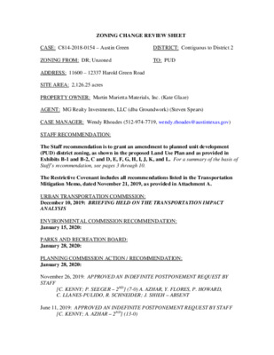
ZONING CHANGE REVIEW SHEET DISTRICT: Contiguous to District 2 TO: PUD CASE: C814-2018-0154 – Austin Green ZONING FROM: DR; Unzoned ADDRESS: 11600 – 12337 Harold Green Road SITE AREA: 2,126.25 acres PROPERTY OWNER: Martin Marietta Materials, Inc. (Kate Glaze) AGENT: MG Realty Investments, LLC (dba Groundwork) (Steven Spears) CASE MANAGER: Wendy Rhoades (512-974-7719, wendy.rhoades@austintexas.gov) STAFF RECOMMENDATION: The Staff recommendation is to grant an amendment to planned unit development (PUD) district zoning, as shown in the proposed Land Use Plan and as provided in Exhibits B-1 and B-2, C and D, E, F, G, H, I, J, K, and L. For a summary of the basis of Staff’s recommendation, see pages 3 through 10. The Restrictive Covenant includes all recommendations listed in the Transportation Mitigation Memo, dated November 21, 2019, as provided in Attachment A. URBAN TRANSPORTATION COMMISSION: December 10, 2019: BRIEFING HELD ON THE TRANSPORTATION IMPACT ANALYSIS ENVIRONMENTAL COMMISSION RECOMMENDATION: January 15, 2020: PARKS AND RECREATION BOARD: January 28, 2020: PLANNING COMMISSION ACTION / RECOMMENDATION: January 28, 2020: November 26, 2019: APPROVED AN INDEFINITE POSTPONEMENT REQUEST BY STAFF [C. KENNY; P. SEEGER – 2ND] (7-0) A. AZHAR, Y. FLORES, P. HOWARD, C. LLANES-PULIDO, R. SCHNEIDER; J. SHIEH – ABSENT June 11, 2019: APPROVED AN INDEFINITE POSTPONEMENT REQUEST BY STAFF [C. KENNY; A. AZHAR – 2ND] (13-0) C814-2018-0154 Page 2 CITY COUNCIL ACTION: February 14, 2020: ORDINANCE NUMBER: ISSUES: None at this time. CASE MANAGER COMMENTS: The proposed Austin Green PUD contains a 2,126 acre active sand and gravel mining site (a basic industry use) and is generally located at the intersection of SH 130 and Harold Green Road, with limited frontage on FM 973, Platt Lane, and FM 969, and bounded by approximately 3.2 miles of Colorado River frontage along its southern boundary. Except for a portion of the Colorado River frontage west of SH 130 that has development reserve (DR) zoning, the site is currently outside of the City limits and proposed for limited purpose annexation and concurrent creation of a Municipal Utility District (MUD). Similarly, except for the Colorado River frontage, all of the surrounding properties are located outside of the City limits. Land west of SH 130 is characterized by industrial and open space uses, with manufactured home and detached single family residential subdivisions bordering the southwest property boundary. The majority of the adjacent land east of SH 130 functions as open space, with the Austin Colony single family residential subdivision in close proximity to a portion of the east property line. Elm Creek extends through the northern portion of the site, under SH 130 and continues east eventually flowing into the Colorado River. Please refer to Exhibits A, A-1 and A-2 – Vicinity Map, Zoning Map and Aerial Exhibit. PROJECT DESCRIPTION The Applicant proposes to transform the mining operation by creating a planned unit development (PUD) and constructing up to 12,800 residential units, and 2.25 million square feet of office, commercial, industrial and civic uses (“commercial / civic uses”). Local access to the site will be from the extension of Harold Green Road as a 4-lane major arterial across SH 2130 and from a proposed unnamed 2-lane minor arterial extending from FM 973 along the site’s southwest boundary to its northeastern edge. Please refer to Exhibit C – Proposed Land Use Plan. The PUD is divided into four land use areas. The Mixed Use (MU) 1 area (237 acres) is located at the Harold Green extension east of SH 130 and is proposed for up to 6,900 dwelling units and up to 1.2 million square feet of commercial / civic uses. It is also referred to as the Town Center. The MU 2 area (310 acres) is located west of SH 130, totals 310 acres and proposes up to 3,000 dwelling units and 1.2 million square feet of commercial / civic uses. It allows a wide diversity of uses including the horizontal or vertical mixture of commercial, civic, and residential on a single lot or site. Open space is included in all three areas. C814-2018-0154 Page 3 The Mixed Residential (MR) area (870 acres) straddles SH 130 and accounts for up to 6,000 dwelling units and 200,000 square feet of commercial / civic uses. It allows a wide diversity of uses including the horizontal or vertical mixture of commercial, civic, and residential on a single lot or site. Exhibit N illustrates Example Housing Products. The Open Space (OS) area (708 acres) is generally located along the Colorado River, but also includes mining areas along and in proximity to Elm Creek. Up to 100,000 square feet of commercial / civic uses are proposed, to include a public library site. City of Austin water and wastewater service will be provided west of SH 130 and Hornsby Bend Utility Company will provide these services east of SH 130. Austin Energy serves the entire project area. GENERAL TO PLANNED UNIT DEVELOPMENTS Per the Land Development Code, PUD district zoning was established to implement goals of preserving the natural environment, encouraging high quality development and innovative design, and ensuring adequate public facilities and services. The City Council intends PUD district zoning to produce development that achieves these goals to a greater degree than and thus is superior to development which could occur under conventional zoning and other development-related regulations. City Council approved revisions to the PUD regulations that became effective June 29, 2008. To help evaluate the superiority of a proposed PUD, requirements are divided into two categories: Tier 1, which is requirements that all PUDs must meet, and Tier 2 which provides criteria in 13 topical areas in which a PUD may exceed Code requirements and therefore demonstrate superiority. A PUD need not address all criteria listed under Tier 2, and there is no minimum number of categories or individual items required. SUPERIORITY ELEMENTS As more fully detailed in the Tier Table and Land Use Plan the proposed Austin Green PUD meets all 12 of the applicable Tier 1 items, meets one additional Tier 1 items (pertaining to Commercial Design Standards), and offers some elements of superiority in 10 of the 13 Tier 2 categories (Affordable Housing; Art; Commercial Design Standards; Environment and Landscaping; Great Streets Development Program; Green Building; Local Small Business; Parkland and Open Space; Public Facilities; and Transportation and Connectivity). Please refer to Exhibit B-1: Basis for Superiority Table. Given the number and breadth of items offered in the PUD that exceed current code standards, Staff believes the proposal can result in superior development along major thoroughfares in southeastern Travis County based on the following factors which make this project superior: Affordable Housing • 15% of rental units to be provided at 60% median family income (MFI) for 40 years • 5% of for sale units affordable to 80% MFI, restricted with fixed equity and resale agreement for 99 years C814-2018-0154 Page 4 Art • Participate in the Art in Public Places Program. The Public Art Master Plan identifies opportunities and locations within the PUD for outdoor art installations to be implemented and managed by the Developer. The Public Art Master Plan shall consist of a minimum of two (2) significant art pieces. Commercial Design Standards • Compliance with Chapter 25-2, Subchapter E (Design Standards and Mixed Use) for the MU 1, MU 2 and MR land use areas • Buildings in the Town Center (MU 1 area) must comply with Section 3.2.2 (Building • Design Standards) and have 10% more points than Code requires. Industrial uses in the MU 2 area are subject to standards for the Relationship of Buildings to Streets and Walkways, Building Entryways, Exterior Lighting, and Screening of Equipment and Utilities. • The following applies to commercial or mixed use buildings in the MU 1 area: At least 75% of the building frontage of all parking structures shall be designed for pedestrian-oriented uses as defined in Section 25-2-691(C) (Waterfront Overlay District Uses) in ground floor spaces. Environmental and Landscaping (Additional items forthcoming) • Use of Atlas 14 floodplain and regulations Great Streets Development Program • The Great Streets Development Program or a successor program applies to commercial, retail, or mixed use development that is not subject to the requirements of Chapter 25-2, Subchapter E (Design Standards and Mixed Use). Green Building • All buildings in the Austin Green PUD shall achieve a two-star or greater rating under the Austin Energy Green Building program using the applicable rating version in effect at the time a rating registration application is submitted for the building. Local Small Business • One lease space for retail or restaurant use with a maximum size of 2,500 square feet will be affordable for 10 years at 80% median rental rate, following approval of a building permit. Parkland and Open Space • 858 total acres of parks and open space: 708.22 acres to be dedicated to the City; 150 acres of parks in MU 1, MU 2, MR (includes CWQZ and CEFs) • 6 miles of trails, including a 3 mile trail along the Colorado River Public Facilities • 2.5 acre buildable site for a City of Austin Fire and EMS station, with the location agreed to by DSD and AFD. • A 1 acre site for a public library. The site may be located in the OS district. C814-2018-0154 Page 5 • 3 Del Valle ISD sites (35 acre elementary/middle school; a minimum 12 acre elementary school site) • Within the Austin Water service territory (west of SH 130): All proposed commercial, industrial, and multi-family properties, street medians, public open space and parks, and private parks and recreational facilities shall use an approved alternate water source, including but not limited to rainwater harvesting, air conditioning condensate or reclaimed water, as the primary water sources for all landscape irrigation within the Austin Green PUD. • Within the Austin Water service territory (west of SH 130): All proposed commercial and multi-family developments greater than 250,000 square feet within the Austin Green PUD will be constructed using a dual distribution pipe system to allow acceptance of an alternate water supply or the reclaimed water supply from the City for non-potable water uses within the building. Transportation and Connectivity • Transportation improvements to FM 969 and FM 973, as outlined in the TIA. CODE MODIFICATIONS There are numerous modifications to Code requirements requested by the Applicant and recommended by Staff. Because the PUD is within the City’s limited purpose jurisdiction, the code sections for the subdivision, transportation, and environmental modifications reference the City’s Land Development Code and Title 30, Austin/Travis County Subdivision Regulations. As summarized below, these include definitions, parkland dedication and fee, allowing a site to cross a right-of-way; land uses; site development regulations and compatibility standards; block length, access to lots, phased site plan, expiration of a preliminary plan and a site plan; street design and construction standards; parking facility standards; and geometric design criteria for streets. Please refer to Exhibit B-2 – Code Modification Table. The proposed modifications to the PUD ordinance and accompanying land use plan are summarized below: General Section 25-1-21 (Definitions) – Addition: Access Lot means a lot on a plat that provides street frontage and joint access for lots that are served by only an alley Section 25-1-21 (Definitions) – Modification: a Block means one or more lots, tracts, or parcels of land bounded by streets (public or private), 30 feet wide or lager pedestrian paseo or courtyard with a minimum 5 foot sidewalk or trail, public or private park space / open space, easement or plaza space, railroads, or subdivision boundary lines Section 25-1-21 (Definitions) – Addition: Common courtyard means a lot on a plat that provides street frontage and common green area for lots that are served by only an alley. Buildings that face onto a common courtyard shall be addressed off the nearest street that connects to the common courtyard. This type of housing shall be C814-2018-0154 Page 6 treated like a single-family structure during permitting processes, thus not subject to site development permit. Section 25-1-21 (Definitions) – Modification: Gross Floor Area includes parking structures. Section 25-1-21 (Definitions) – Addition: Live / Work Unit is defined according to the International Building Codes and any amendments to the Land Development Code. Section 25-1-21 (Definitions) – Addition: Mixed Residential (MR) means the land use areas identified as MR on Exhibit C – Proposed Land Use Map and Density Table. Section 25-1-21 (Definitions) – Addition: Mixed Use (MU) means the land use areas identified as MU on Exhibit C – Proposed Land Use Map and Density Table. Section 25-1-21 (Definitions) – Addition: Multi-Unit House means a unified structure on one lot designed to appear like a large single family residence, but is divided into three to eight separate units each with an individual entry. This type of housing shall be treated like a single family structure during permitting process, and is not subject to a site development permit. Section 25-1-21 (Definitions) – Addition: Open Space (OS) means the land use area identified as OS on Exhibit C: Proposed Land Use Map and Density Table. Section 25-1-21 (Definitions) – Addition: Paseo Court means a group of two to eight dwelling units that may be accessed by a private driveway. The Court may or may not be subdivided lots per unit. Buildings that face onto a paseo court shall be addressed off the nearest street that connects to the paseo court. This type of housing shall be treated like a single family structure during permitting processes, and is not subject to a site development permit. Section 25-1-21(98) (Definitions) – Modification: Roadway includes alley and / or private road. Section 25-1-21(105) (Definitions) – Modification: A site within the Austin Green PUD may cross a public street or right-of-way. Section 25-1-21(110) (Definitions) – Modification: A standard lot means a lot of at least 1,000 square feet. Section 25-1-21 (Definitions) – Addition: Yard House is one of several forms of single family residential uses. This use allows an accessory dwelling unit, but only if it is constructed over the garage. This type of housing shall be treated like a single family structure during permitting processes, and is not subject to a site development permit. C814-2018-0154 Page 7 Section 25-1-602 (Dedication of Parkland (A)) – Modification: Subject to the terms of Exhibit F: Proposed Parkland and Open Space Master Plan. Section 25-1-606 (Parkland Development Fee) – Modification: The amount of the development fee is set at $100 per dwelling unit more than what the fee would be required by Code and as updated annually. Any surplus funds may be used as a credit for future phases. Zoning Section 25-2-243 (Proposed District Boundaries) – Modification: The boundaries of the Austin Green PUD may be non-contiguous. Section 25-2, Subchapter B, Article 2, Subpart C, Section 3.2.2 (C) (Residential Uses) – Removal: Floor-to-area (FAR) for multifamily development. The primary criteria for density shall be based on impervious cover, unit count and height maximums Section 25-2, Subchapter B, Article 2, Subpart C, Section 3.2.3 (C) (Nonresidential Uses) – Removal: Floor-to-area for non-residential development. The primary criteria for density shall be based on impervious cover, unit count and height maximums. Section 25-2, Subchapter B, Article 2, Subpart C, Section 3.2.3 (C) (Nonresidential Uses) – Modification: Front yard setbacks and street side yard setbacks are in accordance with Exhibit E: Proposed Site Development Regulations Section 25-2, Subchapter B, Article 2, Subpart B, Section 3.2.4 (Industrial Uses) – Modification: The existing and potential future relocation of the batch plant / aggregate processing facility shall meet the performance standards in the existing site development permits for the current batch plant / aggregate processing facility. All other industrial uses must comply with the performance standards established by Section 25-2-648 (Planned Development (PDA) Performance Standards). Section 25-2, Subchapter B, Article 2, Subpart B, Section 2.5.2.B. (Requirements for Exceeding Baseline) – Modification: For developments with no residential units, either provides contract commitments and performance guarantees that provide affordable housing meeting or exceeding the requirements of Section 2.5.3 (Requirements for Rental Housing) and Section 2.5.4 (Requirements for Ownership Housing). Section 25-2, Subchapter E: (Design Standards and Mixed Use); Section 1.2.4 (Exemptions) – Modification – Industrial Uses in MU-2 shall not be exempt from the following Standards: 2.2 (Relationship of Buildings to Streets and Walkways), 2.4 (Building Entryways), 2.5 (Exterior Lighting), 2.6 (Screening of Equipment and Utilities). Section 25-2-491 (Permitted, Conditional, and Prohibited Uses) – Establishes a specific set of permitted land uses for the PUD. C814-2018-0154 Page 8 Section 25-2-492 (Site Development Regulations) – Establishes a specific set of site Section 25-2-770 (Conservation Single Family Residential Use) – Addition: Allows development regulations for the PUD. this use within the PUD. Section 25-2-772 (Single Family Attached Residential Use) – Modification: Allows this use within the PUD in accordance with Exhibit E: Proposed Site Development Regulations. Section 25-2-775 (Townhouses) – Modification: Allows this use within the PUD in accordance with Exhibit E: Proposed Site Development Regulations. Section 25-2-779 (Small Lot Single Family Residential Use) – Modification: Allows this use within the PUD in accordance with Exhibit E: Proposed Site Development Regulations. Section 25-2-1006 (A) (1 through 2) (Visual Screening) – Modification: Only green stormwater quality facilities that comply with Environmental Criteria Manual 1.6.7 criteria, and are designed to serve as amenities, are exempt from screening required by Section 25-2-1006(A). Section 25-2-1051 (Applicability: Compatibility Standards) – Modification: Compatibility standards are not triggered between tracts within the Austin Green PUD. Compatibility standards apply to residential subdivisions outside and adjacent to the Austin Green PUD exterior boundaries. Section 25-2-1052 (Exceptions: Compatibility Standards) – Addition: Compatibility standards from one of the five parcels to another parcel is not required. Section 25-4-62 (Expiration of Approved Preliminary Plan) – Modification: Allow an approved preliminary plan to expire seven (7) years after the date the application for approval of the preliminary plan is submitted. Note: Staff does not agree with modifying this section from the standard five (5) years. Section 25-4-153 (A) (Block Length) – Modification: A block may exceed 1,600 feet if future connections will be constructed that will reduce the block to not more than 1,600 feet, and such streets are depicted on plans. Subdivision Section 25-4-153 (B) (Block Length) – Modification: A block may be up to 2,000 feet if future connections will be constructed that will reduce the block to not more than 2,000 feet, and such streets are depicted on plans. Section 25-4-153 (B) (Block Length) – Addition: A block adjacent to open space, utility easements, mine land or other encumbrances to connectivity are exempt from these requirements. C814-2018-0154 Page 9 Section 25-4-171 (Access to Lots) – Addition: In the case where the home faces common courtyard or private street, the alley will be a dedicated public street. Sections 25-4-174 and 30-2-174 (Lot Size) – Modification: Lot sizes shall be replaced by Exhibit E: Site Development Regulations. Sections 25-4-232 (C) (1 through 21) and 30-2-232 (Small Lot Subdivisions) – Modification: Lot sizes and setbacks shall be replaced by Exhibit E: Site Development Regulations. Sections 25-4-232 (C) (22) and (D) (5), and 30-2-232 (Small Lot Subdivisions) – Modification: Maintenance of a common area or access easement is the responsibility of the adjoining property owner, the homeowners’ association or the MUD. Sections 25-4-233 (E) and 30-2-233 (E) (Single Family Attached Residential Subdivision) – Modification: Lot sized and setbacks are replaced by Exhibit E: Proposed Site Development Regulations. Site Plan Section 25-5-21 (Phased Site Plan) – Modification: Allow approved development phasing if the date proposed for beginning construction on the final phase is not more than seven (7) years after the approval date for the site plan. Planning Commission approval is required for development phasing if the date proposed for beginning construction of a phase is more than seven (7) years after the approval date of the site plan. Note: Staff has an alternate recommendation of five (5) years. Section 25-5-81 (Site Plan Expiration) – Modification: Allow a site plan to expire seven (7) years after the date of its approval. Note: Staff has an alternate recommendation of five (5) years. Transportation Section 25-6-114 (Neighborhood Traffic Analysis Required) – Removal: A Neighborhood Traffic Analysis will not need to be updated if development proceeds as approved in the PUD. Section 25-6-116 (Desirable Operating Levels for Certain Streets) – Removal: A Traffic Impact Analysis will be reviewed and approved with the zoning. The TIA will focus on intersection operations and will recommend street cross-sections based primarily on the anticipated function of the roadway. Sections 25-6-171 and 30-3-71 (Standards for Design and Construction) – Modification: Travis County may administratively approve the use of innovative or alternate roadway designs that are not listed in the Transportation Criteria Manual, City of Austin Standards and Standard Specifications, or Exhibit H: Typical Road Sections. Note: Additional language will be added that specifies when the cross- sections are applicable (limited versus full-purpose jurisdiction). C814-2018-0154 Page 10 Section 25-6-292 (Design and Construction Standards) – Modification: Vehicular access to a lot from a public alley is permitted. Section 25-6-472 (Parking Facility Standards) – Modification: Except as provided in Section 25-6-473 (Modification of Parking Requirement), a parking facility for a use must comply with 60 percent of that prescribed by Section 25-6 Appendix A (Tables of Off-Street Parking and Loading Requirements) in the MU 1 area. Additional information forthcoming Transportation Criteria Manual 1.3.0 (Geometric Design Criteria) – Modification: A design speed of 25 miles per hour is permitted on local streets within the MR area. Additional discussion needed Environmental (Additional items forthcoming) EXISTING ZONING AND LAND USES: ZONING Site North Unzoned South DR; LI-PDA; I-RR; Unzoned DR; Unzoned East Unzoned West Unzoned LAND USES Sand and gravel mining operations Undeveloped; Commercial Colorado River; Single family residences and manufactured homes in the Valle del Rio Addition subdivision; Undeveloped; City of Austin Electric Substation; Southeast Austin Regional Wastewater Treatment Plant Colorado River; Agricultural; Mining; Single family residences in the Austin’s Colony subdivision Mining; Undeveloped; Manufactured homes in the Garden Valley and Green Grove subdivisions; Single family residences in the Prado Ranch and Hornsby Glen subdivisions MUNICIPAL UTILITY DISTRICT: Austin Green WATERFRONT OVERLAY: No TRANSPORTATION IMPACT ANALYSIS: Is required – Please refer to Attachment A WATERSHEDS: Elm Creek, Colorado River Watersheds – Suburban CAPITOL VIEW CORRIDOR: No CORE TRANSIT CORRIDORS: None SCENIC ROADWAY: SH 130 C814-2018-0154 Page 11 SCHOOLS: The subject property is within the Del Valle Independent School District. NEIGHBORHOOD ORGANIZATIONS: 511 – Austin Neighborhoods Council 774 – Del Valle Independent School District 1195 – Imperial Valley Neighborhood Association 1228 – Sierra Group, Austin Regional Group 1363 – SEL Texas 1530 – Friends of Austin Neighborhoods 1616 – Neighborhood Empowerment Foundation AREA CASE HISTORIES: 627 – Onion Creek Homeowners Association 1005 – Elroy Neighborhood Association 1258 – Del Valle Community Coalition 1528 – Bike Austin 1550 – Homeless Neighborhood Association REQUEST I-RR to P COMMISSION To Grant P CITY COUNCIL Apvd P (6-28-2018). NUMBER C14-2017-0012 – South Austin Regional Wastewater Treatment Plant Electrical Substation No. 1 Replacement – 1017, 1101 and 1103 Fallwell Ln C14-2013-0024 – Onion Creek Greenway – 4439 East SH 71, Unit B C14-99-2052 and C14-99-2053 – Austin Interport (East and West) – Fallwell Ln. at SH 71 East I-RR to P To Grant P Apvd P (5-9-2013). DR, I-SF-2, I-RR to LI-PDA To Grant GR; MF-3 w/conds Apvd LI-PDA with attached site development standards, RCs for 175’ reservation of r- o-w on SH 71 (9-28-2000). RELATED CASES: Development Assessment A Development Assessment for Austin Green PUD was submitted on September 27, 2018. In accordance with the revised regulations for PUDs, a briefing was presented to Council on December 13, 2018 (CD-2018-0008). On December 19, 2018, the Applicant filed the subject PUD zoning application. C814-2018-0154 Page 12 Municipal Utility District As background, it is City policy that developers of MUDs pursue PUD zoning so that when the project is eventually annexed into the City limits, the development generally tracks with the City’s development standards. A MUD application was filed on December 20, 2018 and is being processed concurrently, with Council review scheduled for January 23, 2020 (C12M-2018-0005). A previously proposed MUD on the property known as Rio de Vida was filed on December 10, 2010. The MUD was later created by Senate Bill 768 (SB 768) in the 2011 Texas Legislature. Due to a lack of consent agreement, the MUD expired on September 1, 2012 per language in SB 768. Up to 8,000 residential units and 12 million square feet of commercial uses were proposed on approximately 2,130 acres. Site Plans The property has been actively mined since the 1960s with development permits that allow for mining and other grading activities. EXISTING STREET CHARACTERISTICS: Name Classification Pavement ROW Sidewalks Bicycle Route SH 130 720 – 785 feet 90 – 160 feet ASMP Levels 4 None None FM 973 Road Platt Lane Harold Green Drive FM 969 Road 72 – 86 feet 50 feet 50 – 65 feet 35 feet 15 feet 25 feet 200 – 295 feet 35 – 63 feet and 5 (Major Arterial and Highway) ASMP Level 4 (Major Arterial) ASMP Level 1 (Local) ASMP Level 2 (Collector) ASMP Level 4 (Major Arterial) None None None None Capital Metro (within ¼ mile) None None None None None Shared Lane None Wide Curb Lane Wide Curb Lane C814-2018-0154 Page 13 OTHER STAFF COMMENTS: Comprehensive Planning This property consists of five tracts of land, when combined total 2,126.25 acres in size. The properties are located on the east and west side of North FM 973, the east and west side of SH 130, and north and south side of Harold Green Road. The properties were originally used as agricultural and ranch land, and later on for sand and gravel mining, which has impacted the site with environmental and geographic constraints. Surrounding uses include mining, and undeveloped land to the north, south and west, and two single family subdivisions abutting the property to the east. Residential subdivisions are also located to the west. The proposal according to the developer is to create ‘a mixed use, integrated and intense Town Center’ which will include 12,800 units of housing, including single family houses, townhouses, apartments, row houses, Paseo courts, live/work, yard houses, and tiny houses; 2.25 million sf of commercial uses including light industrial, office and retail; and a variety of civic uses including a fire station, parkland and open space, providing land for a 35 acre middle/elementary school and a 12 acre elementary school, and one (1) acre being set aside for a public library. The following are some of the goals of this project: o Creating a model project ‘that results in a great live, work, play community and enhances ecological systems while the site transitions from mining to a mixed use development.’ o Providing 10% combined affordable housing units (1,200 units), at a mix of 80% MFI for sale and 60% MFI for rent. o Capitalizing on the site’s location, access and visibility to achieve long term goals that the City of Austin has outlined in Imagine Austin, including: o Attainable and diverse housing; o Create job opportunities where people live to reduce dependency on an overburdened transportation system; and o Pursue a compact development strategy that provides substantial future tax base to help the City fund its operation. o Embracing the outdoor environment as part of the living and working experience. o Aligning transportation goals from various agencies with practical solutions. o Aligning the project with the City’s Six Strategic Outcomes of Economic Opportunity and Affordability, Mobility, Safety, Health and the Environment, Culture and Lifelong Learning, and Government that Works for All. C814-2018-0154 Page 14 The project also calls for a number of mobility and recreational amenities including: shaded public sidewalks, bike lanes, shared paths, and connectivity options linking this community to the Austin Colony neighborhood. The developers also wants to work with Cap Metro to get public transit into the project area. The project also proposes to preserve 39 percent of the site (or approximately 858 acres) for open space and parks. Connectivity The Walkscore for this area is 0/100, Car Dependent, meaning almost all errands require a car. There are no transit stops, public sidewalks or bike lanes in this area. Because this area was used for mining, connectivity and mobility options (beyond a car) are almost non- existent. The developer also stated in their PUD application that the extension of Harold Green Road will be coordinated with Travis County and will include public sidewalks and protected bike lanes. The project area also proposes to build a network of trails throughout the development to enhance the connectivity. The developer is also considering installing a park and ride facility within the project area and has promised to contact Cap Metro every five years to supply transit service to and from this development. The developer has also agreed to participate in Austin Great Streets program, and provide bike facilities throughout the project area. If all these mobility options are implemented, the mobility options will be above average. Imagine Austin The project area is identified as the Rio di Vida Town Center on the Imagine Austin Growth Concept Map. Town Centers are intended to support a variety of housing types and a range of employers with regional customer and employee bases. Town Centers are the mid-sized of the three activity centers outlined in the Growth Concept Map. These centers are intended to have a variety of housing types and a range of employers with regional customer and employee bases, and provide goods and services for the center as well as the surrounding areas. The following Imagine Austin policies are also applicable to this case. • LUT P1. Align land use and transportation planning and decision-making to achieve a compact and connected city in line with the growth concept map. • LUT P3. Promote development in compact centers, communities, or along corridors that are connected by roads and transit that are designed to encourage walking and bicycling, and reduce health care, housing and transportation costs. Complete Community Policies • LUT P4. Protect neighborhood character by directing growth to areas of change that includes designated redevelopment areas, corridors and infill sites. Recognize that different neighborhoods have different characteristics and new and infill development should be sensitive to the predominant character of these communities. • LUT P5. Create healthy and family-friendly communities through development that includes a mix of land uses and housing types and affords realistic opportunities for C814-2018-0154 Page 15 transit, bicycle, and pedestrian travel and provides both community gathering spaces, parks and safe outdoor play areas for children. • HN P10. Create complete neighborhoods across Austin that have a mix of housing types and land uses, affordable housing and transportation options, and access to schools, retail, employment, community services, and parks and recreation options. Analysis and Conclusions Growing as a ‘compact and connected city’ to create ‘complete communities’ is the basis of the Imagine Austin vision statement and the hundreds of policies and actions developed throughout the plan. Growing as a compact and connected city,”… enhances human connections, innovation, and urban vibrancy. Creating a more compact and efficient city is critical to our ability to connect people to homes, jobs, schools, and other destinations with a more complete transportation system that is affordable to build, operate, and maintain. (p 10). The proposed PUD mixed use project appears to contribute towards making this area a more complete community by including a mixture of uses (live, work and play) in an area that currently offers few of these options. The project also appears meets a number of Imagine Austin core principles for action (p. 10 - 11) including: (1) Grow as a Compact, Connected city by including a mix of uses (residential, light industrial, office, commercial, and civic uses along with a variety of mobility options – shared path, bike lanes and public sidewalks; (2) Integrates Nature Into the City providing parks and open spaces. and (5) Provide Paths to Prosperity for All, by providing a variety of housing types, including affordable housing, live/work options, and employment within the project area. In summary, this PUD project appears to be planned to be a ‘complete community’ and a true Town Center and therefore supports the policies and concepts of the Imagine Austin C814-2018-0154 Page 16 Comprehensive Plan. C814-2018-0154 Page 17 Electric Review The site must comply with safety clearances and setback requirements from the utility criteria manual if underground and/or overhead electrical facilities are present. Site Characteristics: Existing Land Use / Topography / Soil Characteristics / Vegetation The proposed PUD site is currently used for mining purposes. Topographically, the elevation ranges from 386 to 482 feet above mean sea level. The property consists of silt loam, silty clay loam, loamy fine sand, and clay soils. Predominant tree species on the site are woodland species and include hackberry, cedar elm, and cottonwood. Additionally, there is grassland / prairie / savanna on the subject site which includes Johnson grass and Chinese tallow. Hydrophytic vegetation includes cattail, black willow, brushy bluestem, Texas rush, and pale smartweed. Critical Environmental Features An Environmental Resource Inventory (ERI) of the project site was prepared by ACI Consulting in April 2019. The ERI identified 84 potential wetland vegetation areas and 17 springs / seeps. There are two water wells in use on the subject site. Impervious Cover The maximum impervious cover allowed by the PUD is 65% (1,382 acres). One (1%) percent of the total impervious cover allowed is reserved for use within the Open Space land use district or other parkland. Environmental Please refer to Attachment B. Floodplain Review Site is located along the SH 130 corridor from FM 969 to the Colorado River. Large portions of the property are within the studied floodplain of Elm Creek. Large portions of the property are gravel mining operations and the PUD aims to set a path forward for development as mining operations are phased out. Area did previously have a CLOMR which was superseded by the City of Austin’s floodplain study for Elm Creek in ~2010. Our understanding of flood risk in Austin is changing. What is now known as the 500-year floodplain is a good representation of what the 100-year floodplain will be according to a National Weather Service publication called Atlas 14. This could affect the layout of this development, including the location of lots, drainage easements, and roadways. The City will likely be using the current 500-year floodplain as the design floodplain for site development permits by the end of 2018/beginning of 2019. In order to minimize flood risk to our community and better ensure that development can be in compliance with future C814-2018-0154 Page 18 floodplain regulations, the City of Austin recommends that you consider the 500-year floodplain as a surrogate for the 100-year floodplain when designing this development. Applicant will be using 500-yr floodplain on Elm Creek and 100-yr floodplain on Colorado River for regulatory purposes. Applicant will be required to meet floodplain regulations in effect at the time of site development permits. For purposes of determining no adverse floodplain impacts within the site, the Applicant should use existing regulatory floodplain modeling and mapping revised to incorporate what the post-mining terrain will be as allowed by the current mining permit. Applicant has agreed to use proposed Atlas 14 floodplains and regulations. Modeling approved as “proof of concept”; refined modeling is required to be provided for each subdivision / site plan submittal. Keep in mind in any situation where revegetation is proposed within the floodplain that proposed conditions. Manning’s roughness values will need to account for projected vegetation growth. Any proposed diversions of flood water that contain or direct flow from Elm Creek across the site to the Colorado River will likely require a CLOMR application. A CLOMR will be required if there are any alterations to the diversion amounts across or through the site including if changes are to be made to the crossing at SH 130 which would impact the amount of flow through the crossing. Keep in mind that increasing flow through the crossing may be considered an adverse impact if it adversely impacts the depth or duration of flooding on properties outside of the PUD district. Applicant confirms that CLOMRs, if needed, will be completed as the design and modeling progresses. FYI: FEMA map changes will be coordinated as follows: portions of the site within the full purpose and planning jurisdiction of the City of Austin will be reviewed and acknowledged by the City, and portions of the site located within the ETJ will be handled by Travis County. FYI: Floodplain will need to be contained within a drainage easement. Be aware that at any given time, the floodplain physically on the site must be contained to a drainage easement. FYI: The project area will be expected to handle all of the current overflows from Elm Creek as outlined in LDC 25-7-151. It is assumed this is part of the reason for the number and size of proposed ponds. It is noted that all the additional ponds are indicated to be Retention ponds instead of Detention which may limit their use as flood detention. Ponds meant for flood detention must draw down within 24 hours per the Drainage Criteria Manual. FYI: Much of the proposed “Open Space/Parkland” area is within the current floodplain. Current Code does not allow full credit for parkland which is within floodplain. Be aware that for proposed trails within the floodplain, signage will be required informing users of the flood risk (refer to signs along Shoal Creek Trail between 5th and West; other signs may be proposed but must be approved by the Floodplain office). C814-2018-0154 Page 19 Austin Energy – Transmission Engineering The amount of electric power needed for this proposed PUD will require substantial electrical infrastructure and necessary facilities to adequately provide electric service. Of primary importance are the following variables: • The proposed PUD will require a Substation – This land will need to be acquired by AE / COA and to permit by right major utility facilities use (a classification within the civic use category). This is defined as the use of a site for the provision of generating plants, electrical switching facilities or primary substations, etc. • The Substation will require transmission structures to provide electric power. • The transmission structures will require an easement(s). • Easements will need to be acquired by Austin Energy. Transmission Easements can vary in width but typically are 100’ wide, which place restrictions on what can occur within them, that may adversely affect the planning for this PUD, depending on where these easement(s) lie, at the time of dedication. Owner may not place, erect, construct or maintain the following within the electric transmission easement: • any permanent structures, including, but not limited to habitable structures such as homes, mobile homes, garages, or offices, • any structure of any kind in such proximity to the electric transmission or distribution lines, poles, structures, towers, or appurtenant facilities as would constitute a violation of the National Electric Safety Code in effect at the time the structure is erected, • nor any structures, including but not limited to, fences, storage sheds, drainage, filtration or detention ponds which would impair Austin Energy’s access to the transmission easements or its lines, poles, structures, towers or appurtenant facilities in the easements. Lots located within the transmission easement cannot be labeled or dedicated as parkland. They can be labeled as greenspace or open space, but not parkland. Any proposed easements crossing or within the transmission easement must be reviewed and approved by Austin Energy prior to execution (including trail easements). The owner/developer of this property shall provide Austin Energy with 24 hour access across the property to the easement, for the installation and ongoing maintenance of electric facilities. Austin Water Utility FYI: The landowner intends to serve the west side of SH 130 with retail City of Austin water and wastewater utilities. The landowner, at own expense, will be responsible for providing any water and wastewater utility improvements, offsite main extensions, water or wastewater easements, utility relocations and/or abandonments required by the proposed land uses. It is C814-2018-0154 Page 20 recommended that Service Extension Requests be submitted to the Austin Water Utility at the early stages of project planning. Water and wastewater utility plans must be reviewed and approved by the Austin Water Utility in compliance with Texas Commission of Environmental rules and regulations, the City’s Utility Criteria Manual and suitability for operation and maintenance. All water and wastewater construction must be inspected by the City of Austin. The landowner must pay the City inspection fees with the utility construction. The landowner must pay the tap and impact fee once the landowner makes an application for a City of Austin water and wastewater utility tap permit. Typical water system operating pressures in the area are above 65 psi. Pressure reducing valves reducing the pressure to 65 psi (552 kPa) or less to water outlets in buildings shall be installed in accordance with the plumbing code. All AWU infrastructure and appurtenances must meet all TCEQ separation criteria. Additionally AWU must have adequate accessibility to safely construct, maintain, and repair all public infrastructure. Rules & guidelines include: 1. A minimum separation distance of 5 feet from all other utilities (measured outside of pipe to outside of pipe) and AWU infrastructure; 2. A minimum separation distance of 5 feet from trees and must have root barrier systems installed when within 7.5 feet; 3. Water meters and cleanouts must be located in the right-of-way or public water and wastewater easements; 4. Easements for AWU infrastructure shall be a minimum of 15 feet wide, or twice the depth of the main, measured from finished grade to pipe flow line, whichever is greater. 5. A minimum separation of 7.5 feet from center line of pipe to any obstruction is required for straddling line with a backhoe; 6. AWU infrastructure shall not be located under water quality or detention structures and should be separated horizontally to allow for maintenance without damaging structures or the AWU infrastructure. 7. The planning and design of circular Intersections or other geometric street features and their amenities shall include consideration for access, maintenance, protection, testing, cleaning, and operations of the AWU infrastructure as prescribed in the Utility Criteria Manual (UCM). 8. Building setbacks must provide ample space for the installation of private plumbing items such as sewer connections, customer shut off valves, pressure reducing valves, C814-2018-0154 Page 21 and back flow prevention devices in the instance where auxiliary water sources are provided. FYI: Dedication of private streets and public utility easements does not obligate the City to approve the placement of City water and wastewater mains within same. Water and wastewater service shall be provided to each lot at their Right of Way frontage. Austin Water Utility – Facilities Engineering • All proposed commercial, industrial, and multi-family properties, street medians, public open space and parks, and private parks and recreational facilities shall use an approved alternate water source, including but not limited to rainwater harvesting, air conditioning condensate or reclaimed water, as the primary water sources for all landscape irrigation within the Austin Green PUD. Potable and/or reclaimed water shall only be used as a backup supply if the primary sources are depleted. Reclaimed water shall not be used for irrigation within water quality controls, critical water quality zones, erosion hazard zones, or other prohibited areas. • All proposed commercial and multi-family developments greater than 250,000 square feet within the Austin Green PUD will be constructed using a dual distribution pipe system to allow acceptance of an alternate water supply or the reclaimed water supply from the City for non-potable water uses within the building. Additionally, the developer agrees to construct, at no cost to the City, reclaimed water infrastructure concurrently with the phased development of the project to meet the reclaimed water needs for commercial and multifamily irrigation and indoor non-potable uses, public open space and parks, and private parks and recreational facilities for each phase of development within the project. >This note will be incorporated into the PUD ordinance. • The developer should consider installing rainwater cisterns and roof downspouts at the time houses are constructed to be used for outdoor irrigation at residences and utilize Austin Water’s rebate program for installing such harvesting systems. • Thorough coordination with the Service Extension Request (“SER”) process to ensure adequate capacity and meet infrastructure planning goals, the Landowner shall provide Austin Water more detail and coordinate the extensions of the future lines, including reclaimed water lines. INDEX OF EXHIBITS TO FOLLOW A, A-1 and A-2: Vicinity Map, Zoning Map and Aerial Map B, B-1 and B-2: Applicant’s Summary Letter, Basis for Superiority Table and Code C: Austin Green Land Use Map and Density Table D: Zoning Use Summary Table E: Site Development Regulations F: Proposed Parkland and Open Space Master Plan and Open Space Amenity Matrix G: Example Parkland Open Space Concepts Modification Table C814-2018-0154 Page 22 H: Typical Road Sections I: Proposed Reclamation Guidelines J: Proposed Plant List for Reclamation in Open Space Areas K: Existing Critical Water Quality Zone (CWQZ) L: Proposed Critical Water Quality Zone (CWQZ) M: Phasing Plan N: Example Housing Products INDEX OF ATTACHMENTS TO FOLLOW A: Traffic Impact Analysis B: Environmental Commission Support Material C: Carbon Impact Statement Correspondence Received Exhibit C: Land Use Map & Density Table - Location Map SUBMITTAL DATE: APRIL 2, 2019 INTERSTATE 35 HWY 290 3 8 1 Y W H E T A T S DECKER LANE 2-MILE ETJ F. M . 9 6 9 STATE HWY 130 F.M. 973 STATE HWY 71 3 8 1 Y W H E T A T S STATE H WY 130 0 2000 4000 8000 NORTH GRAPHIC SCALE Exhibit A - Vicinity Map PUD CASE #: C814-2018-0154-AUSTIN GREEN DR SP-03-0172D SP-06-0607D DR RT RD GILB E FM 969 RD ! ! ! ! ! ! ! ! ! ! ! ! ! ! ! ! ! ! ! ! ! ! ! ! ! ! ! ! ! ! ! ! ! ! ! ! ! ! ! ! ! ! ! ! ! V RD SB RD NB H 130 S H 130 S N S N S V ! ! ! ! ! ! ! ! ! ! ! ! ! ! ! ! ! ! ! ! ! ! N SH 130 SB N SH 130 NB ! ! ! ! ! ! ! ! ! ! ! ! ! ! ! ! ! ! ! ! ! ! ! ! ! ! ! ! ! ! ! ! ! ! ! ! ! ! ! ! ! ! ! ! ! ! ! ! ! ! ! ! ! ! ! ! ! ! ER ST DIF N SA ! ! ! ! ! ! ! ! ! ! ! ! ! ! ! ! ! ! ! ! ! ! ! ! ! ! ! ! ! ! ! ! ! ! ! ! ! ! ! ! ! ! ! ! ! ! ! ! ! ! ! ! ! ! ! ! ! ! ! ! ! ! ! ! ! ! ! ! ! ! ! ! ! ! ! ! ! ! ! ! ! ! ! ! ! ! ! ! AM LN ALE DR DGE DR H K WIC D S K R E BA R E ETH ! ! ! ! ! ! ! ! ! ! ! ! ! ! ! ! ! ! ! ! ! ! ! ! ! ! ! ! ! ! ! ! ! ! ! ! ! ! 05-0011 SP-03-0413D SP-03-0413D ! ! ! ! ! ! ! ! ! ! N FM 973 RD ! ! ! ! ! ! ! ! ! ! ! ! ! ! ! ! ! ! ! ! ! ! ! ! ! ! ! ! ! ! ! ! H 130 NB S S ! ! ! ! ! ! ! ! ! ! ! ! ! ! ! ! ! ! ! ! ! ! ! ! ! ! ! ! ! ! ! ! ! ! ! ! ! ! ! ! ! ! ! ! ! ! ! ! ! ! ! ! ! ! ! !! ! ! ! ! ! ! ! ! ! ! ! ! ! ! ! ! ! ! ! ! ! ! ! ! ! ! ! ! ! ! ! ! ! ! ! ! ! ! ! ! ! ! ! ! ! ! ! HAROLD GREEN RD ! ! ! ! ! ! ! ! ! ! ! ! ! ! ! ! ! ! ! ! ! ! ! ! S SH 130 SVRD SB S SH 130 SVRD NB ! ! ! ! ! ! ! ! ! ! ! ! ! ! ! ! ! ! ! ! ! ! ! ! ! ! ! ! LI-CO PLATT LN ! ! ! ! ! ! ! ! ! ! ! ! ! ! ! ! ! ! ! ! ! ! ! ! ! ! ! ! ! ! ! ! ! ! ! ! ! ! ! ! ! S FM 973 RD ! ! ! ! ! ! ! ! ! ! ! ! ! ! ! ! ! ! ! ! ! ! ! ! ! ! ! ! ! ! ! ! ! ! ! ! ! ! ! ! ! ! ! ! ! ! ! ! ! ! ! ! ! ! ! ! ! GARDEN GATE DR GARDEN MEADOW RD GARDEN GROVE DR ! ! ! ! ! ! ! ! ! ! ! ! ! ! ! ! ! ! ! ! ! ! ! ! GREEN GROVE DR E WALLS WAY S WAY S OLIVIO COYOTE CALL WAY KALE DR NCH DR A R R E K RIN R A D R ELA B O AD LO ! ! ! ! ! ! ! ! ! ! ! ! ! ! ! ! ! ! ! ! ! ! ! ! ! ! ! ! ! ! ! ! ! ! ! ! ! ! ! ! ! ! ! ! ! ! ! ! ! ! ! ! ! ! ! ! ! ! ! ! ! ! ! ! ! ! ! ! ! ! ! ! ! ! ! ! B S 0 3 1 H S S ! ! ! ! ! ! ! ! ! ! ! ! ! ! ! ! ! ! ! ! ! ! ! ! ! ! ! ! ! ! ! ! ! ! ! ! ! ! ! ! ! ! ! ! B N D R V S 0 3 1 H S S ! ! ! ! ! ! ! ! ! ! ! ! ! ! ! ! ! ! ! ! ! ! ! ! ! ! ! ! ! ! ! ! ! ! ! ! ! ! ! ! ! ! ! ! SP-04-0163D ! ! COUNTY ! ! ! ! ! ! ! ! ! ! ! ! ! ! ! ! ! ! ! ! ! ! ! ! ! ! ! ! I-RR ! ! ! ! ! ! ! ! LI-PDA SP-03-0364D ! ! ! ! ! ! ! ! ! ! ! ! ! ! ! ! ! ! ! ! ! ! ! C14-00-2053 LI-PDA L W L A F N L L L E 99-2052 LI-PDA LI-PDA C14-00-2052 LI-PDA P P C14-2017-0012 S P-0 2-0 1 7 8 D SP-01-0514D SP-01-0335D SP-01-0516D P C14-2013-0024 PLANNED UNIT DEVELOPMENT ZONING CASE#: C814-2018-0154 PUD C814-05-0069 Exhibit A - 1 COUNTY ! ! ! ! SP-05-1735D ! ! ! ! ! ! ! ! ! ! DR ( ! ! ( ( I-RR ( (( ELLON RD I-SF-2 ( ( ( ( ( ( ( MH ( ( ( I-SF-2 ( ( ( I-SF-2 ( ( ( ( ( ( (( ( ( ( ( C14-01-0186 ( ( (( ( (( ! ( ( ( ( ( ( ( ( ( ( ! ! ! ! ! ! ! ! ! ! COLORADO RIVER ! ! ! DR ! ! ! MH MH I-SF-2 GUERRERO DR 00-2002 I-SF-2 ! ! ! ! BAR RR MH MH ( ( SUBJECT TRACT ! ! ! ! ! ! PENDING CASE ZONING BOUNDARY ± 1 " = 2,000 ' This product is for informational purposes and may not have been prepared for or be suitable for legal, engineering, or surveying purposes. It does not represent an on-the-ground survey and represents only the approximate relative location of property boundaries. This product has been produced by CTM for the sole purpose of geographic reference. No warranty is made by the City of Austin regarding specific accuracy or completeness. P21 P20 2 A 1 P19 PLATT LN D N FM 973 R Q20 N SH 130 SB S SH 130 SB S SH 130 NB SH 130 TRN O S P D M L A N T O B R R E A E 0 N H R G 3 1 1 HAROLD GREEN RD D S FM 973 R B H 0 N S S 13 S SH 130 SB HAROLD GREEN RD Q21 FM 969 RD 1 2 R21 1 2 1 FM 969 RD 2 1 2 3 1 N SH 130 NB N SH D NB 130 SVR G IL B E R T R D R20 S SH 130 969 RD RAMP NB TO FM DEAFSMITHBLVD W I C 16 12 21 36 33 K H A M 50 L N 51 2 1 35 28 5 29 6 58 62 11 66 109 8 6 10 1 4 7 1 3 26 23 20 13 12 4 Q19 R19 Q18 R18 O T B N 0 3 1 S D L O R A H P M A R N E E R G H S S B N 0 3 1 B S 0 3 1 H S S H S S B N 0 3 1 N L L L E Q17 W L L A F 4 2 6 3 1 5 3 2 GARDEN GATE DRGARDEN GROVE DR 4 1 20 28 17 24 22 34 36 D P18 S FM 973 R GREEN GROVE DR 11 PRADORANCHBLVD 7 OBE WALLS WAY AD S FM 14 973 R 3 38 COYOTECALLWAY 8 36 36 KALE D 7 23 25 8 R 7 4 75 1 D P17 66 78 53 40 77 D R 3 7 9 M F S 8A 7 12 14-B 51-A 11-B 10-B 9A ± 1'' = 2,000' 23 20 24 29 33 2 SUBJECT TRACT ! ! ! ! ! ! PENDING CASE ZONING BOUNDARY CREEK BUFFER PLANNED UNIT DEVELOPMENT ZONING CASE#: LOCATION: SUBJECT AREA: GRID: MANAGER: Exhibit A - 2 C814-2018-0154 General Vicinity of SH130 between Colorado River and FM 969 2,122.27 ACRES P17-19, Q17-21, R18-21 WENDY RHOADES This map has been produced by the Communications Technology Management Dept. on behalf of the Planning Development Review Dept. for the sole purpose of geographic reference. No warranty is made by the City of Austin regarding specific accuracy or completeness. R17 Copyright nearmap 2015