20200115-008b: Austin Green PUD C814-19-0154 Exhibits J-N and Attachments - Backup 3 of 3 — original pdf
Backup
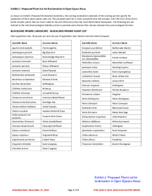
Exhibit J- Proposed Plant List for Reclamation in Open Space Areas As shown on Exhibit I-Proposed Reclamation Guidelines, the existing reclamation standards of the existing permits specify the application of basic plant species seed mix. The proposed plant list is more comprehensive and complex. Even the City’s Grow Green Guide includes plants that are more suited to the arid Hill Country than the moist Bottomland Hardwoods. The following lists are tailored to the individual ecological habitats onsite to promote and enhance their natural characteristics and ecological function. BLACKLAND PRAIRIE LANDSCAPE - BLACKLAND PRAIRIE PLANT LIST Seed application rate: 10 pounds per acre (Source of application rate: Native American Seed Company). Scientific Name Common Name Agalinis heterophylla Andropogon gerardii Andropogon virginicus Asclepias incarnata Asclepias speciosa Asclepias tuberosa Bothriochloa barbinodis Bouteloua curtipendula Buchloe dactyloides Callirhoe involucrata Callirhoe leiocarpa Centaurea americana Chamaecrista fasciculata Chasmanthium latifolum Chloris cucullata Dalea purpurea var. purpurea Desmanthus illinoensis Dracopis amplexicaulis Elymus canadensis Elymus virginicus Engelmannia peristenia Eragrostis trichodes Eriochloa sericea Prairie Agalinis Big Bluestem Broomsedge Bluestem Rose Milkweed Showy Milkweed Butterflyweed Cane Bluestem Sideoats Grama Buffalograss Winecup Annual Winecup American Basketflower Partridge Pea Inland Seaoats Hooded Windmill Grass Purple Prairie Clover Illinois Bundleflower Clasping Coneflower Prairie Wildrye Virginia Wildrye Cutleaf Daisy Sand Lovegrass Texas Cupgrass Scientific Name Eryngium yuccifolium Gaillardia pulchella Glandularia bipinnatifida var. bipinnatifida Helianthus annuus Ipomopsis rubra Leptochloa dubia Lindheimeri texana Monarda citridora Panicum virgatum Paspalum floridanum Penstemon cobaea Plains Bristlegrass Plains Coreopsis Rudbeckia hirta Salvia farinacea Schizachyrium scoparium Silphium albiflorum Sorghastrum nutans Sporobolus cryptandrus Triden albescens Tridens flavus Tripsacum dactyloides Common Name Rattlesnake Master Indian Blanket Prairie Verbena Maximilian Sunflower Standing Cypress Green Sprangletop Texas Yellow Star Lemon Mint Switchgrass Florida Paspalum Foxglove Plains Bristlegrass Plains Coreopsis Black-eyed Susan Mealy Blue Sage Little Bluestem White Rosinweed Indiangrass Sand Dropseed White Tridens Purpletop Eastern Gamagrass Submittal Date: November 27, 2019 Page 1 of 3 PUD CASE #: C814-2018-0154-AUSTIN GREEN Exhibit J: Proposed Plant List for reclamation in Open Spaces Areas Exhibit J- Proposed Plant List for Reclamation in Open Space Areas BLACKLAND PRAIRIE LANDSCAPE - RIPARIAN RECOVERY PLANT LIST Seed application rate: 9 pounds per acre (Source of application rate: Native American Seed Company). Scientific Name Common Name Scientific Name Common Name Andropogon gerardii Andropogon glomeratus Asclepias incarnata Bothriochloa barbinodis Bouteloua curtipendula Chamaecrista fasciculata Chasmanthium latifolum Coreopsis tinctoria Desmanthus illinoensis Dracopis amplexicaulis Elymus canadensis Elymus virginicus Engelmannia peristenia Eriochloa sericea Helianthus angustifolius Helianthus maximiliani Iva annua Scientific Name Acer negundo Carya illinoinensis Celtis laevigata Celtis reticulate Fraxinus pennsylvanica Juglans microcarpa Juglans nigra Juniperus virginiana Maclura ponifera Platanus occidentalis Big Bluestem Bushy Bluestem Rose Milkweed Cane Bluestem Sideoats Grama Partridge Pea Inland Seaoats Plains Coreopsis Illinois Bundleflower Clasping Coneflower Prairie Wildrye Virginia Wildrye Cutleaf Daisy Texas Cupgrass Swamp Sunflower Maximilian Sunflower Marsh Elder Common Name Box Elder Pecan Sugar Hackberry Netleaf Hackberry Green Ash Little walnut Black Walnut Eastern red cedar Bois d’Arc American Sycamore TRANSITIONAL SAVANNA LANDSCAPE Leptochloa dubia Lobelia cardinalis Monarda citridora Oenothera speciosa Panicum virgatum Paspalum floridanum Rudbeckia hirta Salvia coccinea Setaria scheelei Setaria vulpiseta Sorghastrum nutans Sporobolus airoides Sporobolus cryptandrus Triden albescens Tripsacum dactyloides Verbesina virginica Green Sprangletop Cardinal Flower Lemon Mint Pink Evening Primrose Switchgrass Florida Paspalum Black-Eyed Susan Scarlet Sage Southwestern Bristlegrass Plains Bristlegrass Indiangrass Alkali Sacaton Sand Dropseed White Tridens Eastern Gamagrass Frostweed Scientific Name Common Name Populus deltoides Quercus fusiformis Quercus macrocarpa Quercus shumardii Quercus stellate Salix nigra Taxodium distichum Ulmus americana Ulmus crassifolia Ungnadia speciosa Eastern Cottonwood Live oak Bur Oak Shumard Oak Post oak Black Willow Bald Cypress American Elm Cedar Elm Mexican Buckeye Submittal Date: November 27, 2019 Page 2 of 3 PUD Case #: C814-2018-0154 Exhibit J- Proposed Plant List for Reclamation in Open Space Areas BOTTOMLAND HARDWOOD LANDSCAPE Scientific Name Acer negundo Aesculus pavia Baccharis salicina Carya illinoinensis Celtis laevigata Celtis reticulate Common Name Box Elder Red Buckeye Willow Baccharis Pecan Sugar Hackberry Netleaf Hackberry Cephalanthus occidentalis Buttonbush Fraxinus pennsylvanica Ilex decidua Juglans microcarpa Juglans nigra Green Ash Possumhaw Little walnut Black Walnut Juniperus virginiana Eastern red cedar Maclura ponifera Bois d’Arc Scientific Name Morella cerifera Platanus occidentalis Populus deltoides Quercus fusiformis Quercus macrocarpa Quercus shumardii Quercus stellate Sabal minor Salix nigra Taxodium distichum Ulmus americana Ulmus crassifolia Ungnadia speciosa Common Name Wax Myrtle American Sycamore Eastern Cottonwood Live oak Bur Oak Shumard Oak Post oak Dwarf Palmetto Black Willow Bald Cypress American Elm Cedar Elm Mexican Buckeye WETLAND PLANTS Seed application rate: 20 pounds per acre (Source of application rate: Native American Seed Company). Within the inundated areas of wetland benches, herbaceous planting will include individual plants from Exhibit J-Proposed Plant List for Reclamation in Open Spaces Areas and will be planted at 680 plants/acre. The inundated wetland benches will not include woody plantings. The wetland herbaceous plantings will be monitored to a success criteria for years 1 and 2. During year 1, wetland vegetation will include a minimum of 50% aerial cover of the wetland bench (not open water). During year 2, wetland vegetation will include a minimum of 80% aerial cover of the wetland bench (not open water). Wetland plantings densities from professional experience on USACE-approved wetland banks in North Carolina and survival percentages adapted from “Performance Standards and Monitoring Protocols for Nontidal Wetland Mitigation Banks in Maryland” (USACE 2015). Scientific Name Saururus cerenuus Amorpha fruticose Common Name Lizards Tail (FACW) Scientific Name Panicum virgatum Common Name Switchgrass (FAC) Swamp Milkweed (FACW) Platanus occidentalis American sycamore (FAC) Andropogon glomeratus Bushy bluestem (FACW) Populus deltoides Eastern cottonwood (FAC) Asclepias incarnata Carex cherokeensis Swamp milkweed (FACW) Cherokee sedge (FACW) Quercus macrocarpa Bur oak (FACU) Quercus muehlenbergii Chinquapin oak (FAC) Carya illinoinensis Pecan (FAC) Ranunculus abortivus Littleleaf buttercup (FACW) Cephalanthus occidentalis Buttonbush (OBL) Sagittaria latifolia Broadleaf arrowhead (OBL) Chasmanthium latifolium Indian woodoats (FACU) Salix nigra Chasmanthium laxum Slender woodoats (FAC) Taxodium distichum Black willow (FACW) Bald Cypress (OBL) Ilex decidua Deciduous holly (FAC) Tripsacum dactyloides Eastern gamagrass (FAC) Muhlenbergia lindheimeri Lindheimer’s muhly (FACW) Muhlenbergia rigens Deergrass (FACU) Submittal Date: November 27, 2019 Page 3 of 3 PUD Case #: C814-2018-0154 EXISTING 0 600' 1200' GRAPHIC SCALE 600' CRITICAL WATER QUALITY ZONE AREAS TOTAL IN ELM CREEK WATERSHED TOTAL IN COLORADO RIVER WATERSHED TOTAL CWQZ AREA ±61 ACRES ±425 ACRES ±486 ACRES AUSTIN GREEN PUD SUBMITTAL EXISTING CWQZ EXHIBIT "M" SUBMITTAL DATE: NOVEMBER 27, 2019 Exhibit K: Existing Critical Water Quality (CWQZ) LEGEND PROPERTY LINE WATERSHED DELINEATION EXISTING CRITICAL WATER QUALITY ZONE (CWQZ) LINEAR SEGMENT OF CWQZ (≈10075 LF) LINEAR CWQZ SEGMENTS LENGTH (LF) SEGMENT 1 2 3 4 5 6 7 8 9 10 635 660 1380 1170 1500 2680 950 500 320 280 PUD CASE #: C814-2018-0154 - AUSTIN GREEN PROPOSED For a complete description of proposed plan, please reference the following exhibits: · · · · · · · · · · · · · · · · · Exhibit A - Description of Property Exhibit B - Zoning Map (provided by COA) Exhibit C - Proposed Land Use Map and Density Table Exhibit D - Proposed Zoning Use Summary Table Exhibit E - Proposed Site Development Regulations Exhibit F - Proposed Parkland & Open Space Master Plan Exhibit G - Example Parkland Open Space Concepts Exhibit H - Typical Road Sections Exhibit I - Proposed Reclamation Guidelines Exhibit J - Proposed Plant List for Reclamation in Open Space Areas Exhibit M - Existing CWQZ Exhibit N - Proposed CWQZ Exhibit R - Carbon Impact Statement Form Exhibit U - Proposed Phasing Map Exhibit V - Code Comparison Chart Exhibit W - CEF and Buffers Exhibit X - Example Housing Products F.M. 969 0 600' 1200' GRAPHIC SCALE 600' 196.56 AC W Y 130 STATE H 505.68 AC ELM CREEK WATERSHED 26.94 AC F.M. 973 18.09 AC STATE HWY 130 69.54 AC 97.03 AC 47.97 AC 178.73 AC 76.61 AC 129.12 AC 50' ERZ SETBACK FROM CENTERLINE OF CWQZ 169.15 AC 104.00 AC COLORADO RIVER WATERSHED 23.53 AC 272.57 AC 110.93 AC PROPOSED CWQZ IN THIS AREA MATCHES EXISTING CWQZ SET BY CITY OF AUSTIN 88.16 AC 89.55 AC CRITICAL WATER QUALITY ZONE AREAS TOTAL IN ELM CREEK WATERSHED TOTAL IN COLORADO RIVER WATERSHED TOTAL CWQZ AREA TOTAL CONSTRAINED CWQZ AREA TOTAL UNCONSTRAINED CWQZ AREA ±106 ACRES ±409 ACRES ±515 ACRES ±21 ACRES ±494 ACRES NOTE: REFERENCE PROPOSED CODE MODIFICATION (25-8-92) REGARDING ESTABLISHING CRITICAL WATER QUALITY ZONES ALONG MAJOR WATERWAYS PER THIS EXHIBIT. AUSTIN GREEN PUD SUBMITTAL PROPOSED CWQZ EXHIBIT "N" (SHEET 1 OF 2) SUBMITTAL DATE: NOVEMBER 27, 2019 LEGEND PROPERTY LINE DRAINAGE AREA BOUNDARY WATERSHED DELINEATION PROPOSED CRITICAL WATER QUALITY ZONE (CWQZ) CONSTRAINED CRITICAL WATER QUALITY ZONE (REF. EXHIBIT "N1") UNCONSTRAINED CRITICAL WATER QUALITY ZONE (REF. EXHIBIT "N1") LINEAR SEGMENT OF CWQZ (≈5230 LF) LINEAR CWQZ SEGMENTS LENGTH (LF) SEGMENT 1 2 3 4 5 6 7 660 290 550 2090 360 740 540 PUD CASE #: C814-2018-0154 - AUSTIN GREEN Exhibit L: Proposed Critical Water Quality (CWQZ) PROPOSED For a complete description of proposed plan, please reference the following exhibits: · · · · · · · · · · · · · · · · · Exhibit A - Description of Property Exhibit B - Zoning Map (provided by COA) Exhibit C - Proposed Land Use Map and Density Table Exhibit D - Proposed Zoning Use Summary Table Exhibit E - Proposed Site Development Regulations Exhibit F - Proposed Parkland & Open Space Master Plan Exhibit G - Example Parkland Open Space Concepts Exhibit H - Typical Road Sections Exhibit I - Proposed Reclamation Guidelines Exhibit J - Proposed Plant List for Reclamation in Open Space Areas Exhibit M - Existing CWQZ Exhibit N - Proposed CWQZ Exhibit R - Carbon Impact Statement Form Exhibit U - Proposed Phasing Map Exhibit V - Code Comparison Chart Exhibit W - CEF and Buffers Exhibit X - Example Housing Products · GENERAL NOTES: · Within 100-year WSE level, species to be from Riparian Recover mix and Blackland Prairie mix (see Exhibit J4-Proposed Plant List for Reclamation in Open Spaces Areas). In areas within the 100-year WSE, approximately 100' of the vegetation listed above will not be mowed. Vegetation varies outside of drainage easement. · · Where CEF buffers occur, no mowing allowed. · If CWQZ is 200’ or larger application rates in alignment with Exhibit I-Reclamation Standards for Open Space will apply. If CWQZ is less than 200’ the application rates for 100% of the 100 year WSE will be applied. OS 4 shall be permitted to have up to 2 acres of mowed area as part of the village center park per Exhibit F-Proposed Parkland & Open Space Master Plan. · s e i r a V h c n e B ) ' 0 1 . n M i ( d e t t i m r e P l i a r T n o i t a c o l n o s d n e p e d n o i t a c o l l i a r T . i n M % 2 n o i t a c o l n o s d n e p e d n o i t a c o d e t t i m r e P l i l l i a r T a r T . c t e , e p a c s d r a h , s r e d u o b l , i g n g d e . n a p l e t i s t a i d e n m r e t e d S 9 0 6 o t d e r o t s e r e b o t Z Q W C e h t f o % 0 7 , s e n o t s s a . d e t i i b h o r p s m e s i t i h c u s y b d e n i f i g n w o m d n a e d s i s d r a d n a t s e g d E , s g o l e b o T l l a h s s e r u t c u r t s p o r D . l l a t " 9 - " 3 e r u t c u r t s p o r D . e n o ' 0 0 5 f o i t s r e v i r g n c a p s h t i w l e n n a h c t o l i p e g a r e v a h t i l w y m o d n a r r u c c o e p o S 1 l : : l e n n a h C t o l i P g n i r e d n a e M 4 l i a c p y T ' l 5 . 3 y e t a m x o r p p A i ) ' 0 1 . i n M ( s e i r a V h c n e B s e i r a V e p o S l d n a 1 : 3 n e e w e B t 1 : 5 s e i r a V e p o S l d n a 1 : 3 n e e w e B t 1 : 5 ) ' 5 . i n M ( s e i r a V h c n e B t n e m e s a E e g a n a r D i ' 0 0 1 e n o Z y t i l a u Q r e t a W l a c i t i r C d n a e n o Z d r a z a H n o s o r E i l e n n a h C t o l i P E S W r a e Y 0 0 1 l ) s e p o S e d S n o i i g n d n e p e D s e i r a V h t i d W ( m o t t o B l e n n a h C ) s e i r a V h t i d W ( t n e m e s a E e g a n a r D i e n o Z y t i l a u Q r e t a W l a c i t i r C d n a I N O T C E S L A C P Y T - I A E R A T N E M E S A E E G A N A R D R O Z Q W C I ' I 0 0 1 > M A R G A D L E N N A H C D E N A R T S N O C N U I I N O T C E S L A C P Y T - I A E R A T N E M E S A E E G A N A R D R O Z Q W C I ' I 0 0 1 F O M A R G A D L E N N A H C D E N A R T S N O C I , ) s e i r a V h t i d W ( h c n e B n o i t a t e g e V % 0 2 - 2 m o r f e g n a r s e p o S l s e i r a V e p o S l d n a 1 : 3 n e e w e B t 1 : 5 l ) s e p o S e d S n o i i g n d n e p e D s e i r a V h d W t i ( m o t t o B l e n n a h C g n i r e d n a e M s e i r a V e p o S l : d n a 1 3 n e e w e B t 1 5 : s e i r a V h c n e B ) ' 5 . i n M ( e n o Z d r a z a H n o s o r E i l e n n a h C t o l i P ) s e i r a V h t i d W ( n h i m o t i W s r e d n a e M t t o B l e n n a h C e h t E S W r a e Y 0 0 1 . c t e , e p a c s d r a h , s r e d u o b l , , s e n o t s s a . d e t i i b h o r p s m e S 9 0 6 o t d e r o t s e r t i h c u s y b d e n i f e b s i i g n w o m d n a s d r a d n a t s o t Z Q W C e h t f o % 0 7 i g n g d e e d s i e g d E , s g o l . n a p l e t i s t a i d e n m r e t e d e b o T l l a h s s e r u t c u r t s p o r D . l l a t " 9 - " 3 e r u t c u r t s p o r D . e n o ' 0 0 5 f o i t s r e v i r g n c a p s h t i w l e n n a h c t o l i p e g a r e v a h t i l w y m o d n a r r u c c o e p o S 1 l : l e n n a h C t o l i P g n i r e d n a e M : 4 l i a c p y T ' l 5 . 3 y e t a m x o r p p A i AUSTIN GREEN PUD SUBMITTAL PROPOSED CWQZ EXHIBIT "N" (SHEET 2 OF 2) SUBMITTAL DATE: NOVEMBER 27, 2019 PUD CASE #: C814-2018-0154 - AUSTIN GREEN PROPOSED For a complete description of proposed plan, please reference the following exhibits: · · · · · · · · · · · · · · · · · Exhibit A - Description of Property Exhibit B - Zoning Map (provided by COA) Exhibit C - Proposed Land Use Map and Density Table Exhibit D - Proposed Zoning Use Summary Table Exhibit E - Proposed Site Development Regulations Exhibit F - Proposed Parkland & Open Space Master Plan Exhibit G - Example Parkland Open Space Concepts Exhibit H - Typical Road Sections Exhibit I - Proposed Reclamation Guidelines Exhibit J - Proposed Plant List for Reclamation in Open Space Areas Exhibit M - Existing CWQZ Exhibit N - Proposed CWQZ Exhibit R - Carbon Impact Statement Form Exhibit U - Proposed Phasing Map Exhibit V - Code Comparison Chart Exhibit W - CEF and Buffers Exhibit X - Example Housing Products 0 600' 1200' GRAPHIC SCALE 600' PROPOSED AFD SITE EXISTING HAROLD GREEN ROADWAY PROPOSED HAROLD GREEN ROADWAY PHASE ACREAGE ASSOCIATED IMPROVEMENTS REGIONAL RETENTION, PARK AND OPEN SPACE NETWORK AND PARKLAND DEDICATION, POTENTIAL PUBLIC ART INSTALLATION PER EXHIBIT I, APPLICABLE RECLAMATION IMPROVEMENTS WATER QUALITY, PARK AND OPEN SPACE NETWORK AND PARKLAND DEDICATION, APPLICABLE WATER QUALITY, UTILITY, & TRANSPORTATION IMPROVEMENTS, APPLICABLE RECLAMATION IMPROVEMENTS REGIONAL RETENTION, PARK AND OPEN SPACE NETWORK AND PARKLAND DEDICATION, POTENTIAL PUBLIC ART INSTALLATION PER EXHIBIT I, APPLICABLE RECLAMATION IMPROVEMENTS REGIONAL RETENTION, PARK AND OPEN SPACE NETWORK AND PARKLAND DEDICATION, APPLICABLE RECLAMATION IMPROVEMENTS PARK AND OPEN SPACE NETWORK AND PARKLAND DEDICATION, APPLICABLE WATER QUALITY, UTILITY, & TRANSPORTATION IMPROVEMENTS, POTENTIAL PUBLIC ART INSTALLATION PER EXHIBIT I, APPLICABLE RECLAMATION IMPROVEMENTS PARK AND OPEN SPACE NETWORK AND PARKLAND DEDICATION, APPLICABLE WATER QUALITY, UTILITY, & TRANSPORTATION IMPROVEMENTS, POTENTIAL PUBLIC ART INSTALLATION PER EXHIBIT I, APPLICABLE RECLAMATION IMPROVEMENTS PARK AND OPEN SPACE NETWORK AND PARKLAND DEDICATION, APPLICABLE WATER QUALITY, UTILITY, & TRANSPORTATION IMPROVEMENTS, APPLICABLE RECLAMATION IMPROVEMENTS PARK AND OPEN SPACE NETWORK AND PARKLAND DEDICATION, APPLICABLE WATER QUALITY, UTILITY, & TRANSPORTATION IMPROVEMENTS, FINAL SUBDIVISION OF SCHOOL TRACT, APPLICABLE RECLAMATION IMPROVEMENTS FLOODPLAIN MITIGATION AND RECLAMATION, PARK AND OPEN SPACE NETWORK AND PARKLAND DEDICATION, APPLICABLE WATER QUALITY, UTILITY, & TRANSPORTATION IMPROVEMENTS, POTENTIAL PUBLIC ART INSTALLATION PER EXHIBIT I, APPLICABLE RECLAMATION IMPROVEMENTS FLOODPLAIN MITIGATION AND RECLAMATION, PARK AND OPEN SPACE NETWORK AND PARKLAND DEDICATION, APPLICABLE WATER QUALITY, UTILITY, & TRANSPORTATION IMPROVEMENTS, POTENTIAL PUBLIC ART INSTALLATION PER EXHIBIT I, APPLICABLE RECLAMATION IMPROVEMENTS PARK AND OPEN SPACE NETWORK AND PARKLAND DEDICATION, APPLICABLE WATER QUALITY, UTILITY, & TRANSPORTATION IMPROVEMENTS, POTENTIAL PUBLIC ART INSTALLATION PER EXHIBIT I, APPLICABLE RECLAMATION IMPROVEMENTS FLOODPLAIN MITIGATION AND RECLAMATION, PARK AND OPEN SPACE NETWORK AND PARKLAND DEDICATION, APPLICABLE WATER QUALITY, UTILITY, & TRANSPORTATION IMPROVEMENTS, APPLICABLE RECLAMATION IMPROVEMENTS PARK AND OPEN SPACE NETWORK AND PARKLAND DEDICATION, APPLICABLE WATER QUALITY, UTILITY, & TRANSPORTATION IMPROVEMENTS FLOODPLAIN MITIGATION AND RECLAMATION, PARK AND OPEN SPACE NETWORK AND PARKLAND DEDICATION, APPLICABLE WATER QUALITY, UTILITY, & TRANSPORTATION IMPROVEMENTS, FINAL SUBDIVISION OF SCHOOL TRACT, POTENTIAL PUBLIC ART INSTALLATION PER EXHIBIT I, APPLICABLE RECLAMATION IMPROVEMENTS REGIONAL RETENTION, PARK AND OPEN SPACE NETWORK AND PARKLAND DEDICATION, APPLICABLE WATER QUALITY, UTILITY, & TRANSPORTATION IMPROVEMENTS, FINAL SUBDIVISION OF AFD TRACT, POTENTIAL PUBLIC ART INSTALLATION PER EXHIBIT I, APPLICABLE RECLAMATION IMPROVEMENTS PARK AND OPEN SPACE NETWORK AND PARKLAND DEDICATION, APPLICABLE WATER QUALITY, UTILITY, & TRANSPORTATION IMPROVEMENTS, APPLICABLE RECLAMATION IMPROVEMENTS NW-A 133.38 NW-B 90.11 NC 291.00 NE 51.32 FE 171.54 EC 269.71 CC 28.25 SE-A 81.06 SE-B 172.35 SE-C 114.40 SC-A 133.86 SC-B 58.19 SW-A 232.25 SW-B 113.07 WC 116.22 FW 69.54 TOTAL 2126.25 LEGEND SITE BOUNDARY PROPERTY LINE PHASING DESIGNATION PROPOSED SCHOOL SITE Proposed Land Use Districts Mixed-Use 1 (MU1)(237.44 ac./11.2%) Mixed-Use 2 (MU2)(310.24 ac./14.6%) Mixed-Residential (MR)(870.35 ac./40.9%) Open Space (OS)(708.22 ac./33.3%) Exhibit M: Phasing Plan PUD CASE #: C814-2018-0154 - AUSTIN GREEN PROPOSED SCHOOL SITE NOTES: 1. PROPOSED PHASES AND ASSOCIATED IMPROVEMENTS ARE APPROXIMATE AT THIS TIME AND IN NO SEQUENTIAL ORDER. OWNER/DEVELOPER SHALL BE ALLOWED TO DEVELOP EACH PHASE SEPARATELY AS THE MARKET CONDITIONS ALLOW. IMPROVEMENTS ASSOCIATED WITH THE TRAVIS COUNTY HAROLD GREEN ROADWAY PROJECT WILL BE CONSTRUCTED AS NECESSARY TO SERVE THE PROPOSED PROJECT AND ARE NOT INCLUDED IN THIS PHASING PLAN. 3. MINING OPERATIONS (INCLUDING RECLAMATION) WILL CEASE WITHIN 200' OF ANY RESIDENTIAL OR CIVIC LAND USE BY 2. THE TIME THE FIRST CERTIFICATE OF OCCUPANCY IS GRANTED. 4. APPLICABLE DOWNSTREAM IMPROVEMENTS (DRAINAGE & WATER QUALITY) TO BE CONSTRUCTED AS REQUIRED FOR APPLICABLE DEVELOPMENT PHASES. 5. PARKLAND IMPROVEMENTS TO BE DEDICATED PROPORTIONALLY TO DEVELOPMENT PHASING IN 25% INCREMENTS. (E.G. 6. AT 25% BUILD OUT OF UNITS, 25% OF PARKLAND WILL BE DEDICATED; AT 50% OF BUILD OUT OF UNITS, 50% OF PARKLAND WILL BE DEDICATED, ETC.) ANY DEVELOPMENT AND ITS ASSOCIATED GRADING, RECLAMATION, AND/OR REVEGETATION WILL DEPICT HOW THE PROJECT ADHERES TO THE STANDARDS SET FORTH IN THIS PUD AT THE TIME OF THAT DEVELOPMENT'S ASSOCIATED PRELIMINARY PLAN, INFRASTRUCTURE IMPROVEMENT PLANS AND/OR SITE DEVELOPMENT PERMIT. ANY GRADING, RECLAMATION OR REVEGETATION WORK THAT OCCURS PRIOR TO A PRELIMINARY PLAN OR NEW SITE DEVELOPMENT PERMIT BUT NOT FOR THE PURPOSE OF DEVELOPMENT (E.G. CONTINUED RESOURCE EXTRACTION) WILL FILE FOR A CORRECTION OR MODIFICATION TO EXISTING PERMITS. 7. REQUIRED URBAN TRAILS AS SHOWN IN THE PUD WILL BE CONSTRUCTED AND DEDICATED WITH EACH APPLICABLE PHASING AREA. URBAN TRAILS SHALL COUNT TOWARD ROUGH PROPORTIONALITY OF TRANSPORTATION IMPROVEMENTS. AUSTIN GREEN PUD SUBMITTAL PHASING PLAN EXHIBIT "U" SUBMITTAL DATE: NOVEMBER 27, 2019 Residential Detached - Common Courtyard Residential Attached - Live/Work Unit, Townhouse Residential Attached - Multi-Unit House (3 to 8 units) Street Street, Court Yard or Open Space Street y e l l A y e l l A t e e r t S 10' min. Building Separation Alley t e e r t S t e e r t S Alley t e e r t S 20' min. courtyard Street Townhouses may be site planned as one single lot or as individual townhouse lots. Street, Court Yard or Open Space Residential Detached - Paseo Court Street, Alley or Park/Open Space Street, Alley or Park/Open Space Street, Alley, Park/Open Space, or Development t r u o C o e s a P Street, Alley, Park/Open Space, or Development t r u o C o e s a P Street, Alley, Park/Open Space, or Development In each paseo, garages always face the paseo court; however all front doors may either face the paseo court or adjacent street, alley, or park/open space consistently within the same paseo Street or Alley AUSTIN GREEN PUD EXHIBIT X- PROPOSED EXAMPLE HOUSING PRODUCTS SUBMITTAL DATE: NOVEMBER 27, 2019 GENERAL NOTES: · Residential products and site layout shown are preliminary and shown for illustrative purposes only to illustrate intent of site design. Final layout, building placement and product to be determined during site plan, building permit, and/or preliminary plan. PROPOSED For a complete description of proposed plan, please reference the following exhibits: · · · · · · Exhibit A - Description of Property Exhibit B - Zoning Map (provided by COA) Exhibit C - Proposed Land Use Map and Density Table Exhibit D - Proposed Zoning Use Summary Table Exhibit E - Proposed Site Development Regulations Exhibit F - Proposed Parkland & Open Space Master Plan · · · · · · · · · · · Exhibit G - Example Parkland Open Space Concepts Exhibit H - Typical Road Sections Exhibit I - Proposed Reclamation Guidelines Exhibit J - Proposed Plant List for Reclamation in Open Space Areas Exhibit M - Existing CWQZ Exhibit N - Proposed CWQZ Exhibit R - Carbon Impact Statement Form Exhibit U - Proposed Phasing Map Exhibit V- Code Comparison Chart Exhibit W - CEF and Buffers Exhibit X - Example Housing Products Exhibit N: Example Housing Products PUD CASE #: C814-2018-0154-AUSTIN GREEN Attachment A Exhibit R – Carbon Impact Statement Form Carbon Impact Statement Project: Austin Green Scoring Guide: 1-4: Business as usual 5-8: Some positive actions 9-12: Demonstrated leadership 1 2 3 4 5 6 7 8 9 10 11 12 Response: Y=1, N=0 Documentation: Y/N Transportation T1: Public Transit Connectivity T2: Bicycle Infrastructure T3: Walkability T4: Utilize TDM Strategies T5: Electric Vehicle Charging T6: Maximize Parking Reductions Water + Energy WE1: Onsite Renewable Energy WE2: Reclaimed Water Land Use LU1: Imagine Austin Activity Center or Corridor LU2: Floor-to-Area Ratio Food F1: Access to Food Materials M1: Adaptive Reuse 0 1 1 1 1 1 0 1 1 1 0 0 Total Score: 8 N N N N N N N N Y N N N The Carbon Impact Statement calculation is a good indicator of how your individual buildings will perform in the Site Category of your Austin Energy Green Building rating. This is for a PUD that will govern the transition of a 2,126.25-acre site from sand and gravel mining to a Major Town Center including allowable land uses such as a variety of compact housing types and commercial developments, connected street and trail improvements, accessible park and open space and other key community benefits. Attachment C Exhibit R – Carbon Impact Statement Form T1. Is any functional entry of the project within 1/4 mile walking distance of existing or planned bus stop(s) serving at least two bus routes, or within 1/2 mile walking distance of existing or planned bus rapid transit stop(s), or rail station(s)? No. The project is outside of current service area. Conversations are in progress to coordinate future needs with CapMetro and a dedicated site for park and ride will be a part of the project. T2. Is there safe connectivity from the project site to an “all ages and abilities bicycle facility” as listed in the Austin Bicycle Master Plan? Yes. The project is planning to connect an internal trail to FM 969. T3. Is the property location “very walkable” with a minimum Walk Score of 70 (found at walkscore.com), or will the project include at least five new distinct basic services (such as a bank, restaurant, fitness center, retail store, daycare, or supermarket)? Yes. The project envisions having a town center and village center, both with a mixture of residential and non-residential uses. We are also requiring all residential units be within a quarter mile or less walking distance from a public amenity, park or trail. T4. Does the project utilize two or more of the following Transportation Demand Management strategies: unbundling parking costs from cost of housing/office space, providing shower facilities, providing secured and covered bicycle storage, and/or providing 2+ car sharing parking spaces for City-approved car share programs? Yes. T5. Will the project include at least one DC Fast Charging electric vehicle charging station? Yes. T6. Does the project utilize existing parking reductions in code to provide 20% less than the minimum number of parking spaces required under the current land development code (or 60% less than the code’s base ratios if there is no minimum parking capacity requirement)? Yes. WE1. Will the project include on-site renewable energy generation to offset at least 1% of building electricity consumption? Unknown at this time. WE2. Will the project include one or more of the following reclaimed water systems: large scale cisterns, onsite grey or blackwater treatment, and reuse or utilization of Austin Water Utility's auxiliary water system to eliminate the use of potable water on landscape/irrigation? Yes. the project will utilize/extend the City of Austin reclaimed water (purple pipe) system to reduce potable water use for landscaping areas. LU1. Is the proposed project site located within one of the centers or corridors as defined in the Imagine Austin Comprehensive Plan Growth Concept Map? Yes. This project is located within one of the identified Town Centers in the Imagine Austin Comp Plan. LU2. If located in an Imagine Austin activity center or corridor, will the proposed project use at least 90% of its entitled amount of floor-to-area ratio? Yes. F1. Will the project include a full service grocery store onsite, or is one located within 1 mile of the project, or will the project integrate opportunities for agriculture to the scale as defined by Austin Energy Green Building? Full service grocery stores are a permitted use within the project. The final site plan and land uses have not been determined at this time. M1. Will the project reuse or deconstruct existing buildings on the project site? No.