20200115-008b: Austin Green PUD C814-19-0154 Presentation — original pdf
Backup
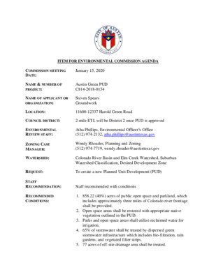
ITEM FOR ENVIRONMENTAL COMMISSION AGENDA COMMISSION MEETING DATE: January 15, 2020 NAME & NUMBER OF PROJECT: Austin Green PUD C814-2018-0154 NAME OF APPLICANT OR ORGANIZATION: Steven Spears Groundwork LOCATION: 11600-12337 Harold Green Road COUNCIL DISTRICT: 2-mile ETJ, will be District 2 once PUD is approved ENVIRONMENTAL REVIEW STAFF: ZONING CASE MANAGER: WATERSHED: REQUEST: STAFF RECOMMENDATION: RECOMMENDED CONDITIONS: Atha Phillips, Environmental Officer’s Office (512) 974-2132, atha.phillips@austintexas.gov Wendy Rhoades, Planning and Zoning (512) 974-7719, wendy.rhoades@austintexas.gov Colorado River Basin and Elm Creek Watershed, Suburban Watershed Classification, Desired Development Zone To create a new Planned Unit Development (PUD) Staff recommended with conditions 1. 858.22 (40%) acres of public open space and parkland, which includes approximately three miles of Colorado river frontage shall be provided. 2. Open space areas shall be restored with appropriate native vegetation outlined in the PUD. 3. Parks and open space areas shall utilize reclaimed water for irrigation. 4. 65% of stormwater shall be treated by dispersed green stormwater infrastructure which includes bio-filtration, rain gardens, and vegetated filter strips. 5. 77 acres of off-site drainage area shall be treated. 6. The project shall provide approximately 50 million cubic feet of additional storage volume for the watershed through a series of on-site retention ponds. Approximately 100 million cubic feet of additional storage volume shall be provided beyond the minimum required for on and off-site flows through three (3) on-site regional retention ponds for the Elm Creek watershed. The proposed 450-acre retention ponds will remove approximately 238 acres of neighboring property and 43 acres of Harold Green Road ROW from the floodplain. These calculations are based on the Atlas 14 flood model for the adjusted 100-year floodplain. 7. Shall provide 29 acres of additional critical water quality zone. 8. Shall preserve 12.91 acres of wetland CEFs, 12.74 acres of wetland CEF shall be enhanced and 9.97 acres of wetland CEF shall be mitigated at 150% acre-for-acre and given the 150-foot buffer required by code. 9. Impervious cover shall be capped at 65% gross site area. 10. Shall preserve a significant stand of trees that have been identified on-site and shall meet current code for tree removal and mitigation. 11. Shall provide 6 miles of public trails throughout the development. 12. Shall meet a Carbon Impact score of 8. Page 2 of 2 Austin Green PUD C814-2018-0154 Atha Phillips, Environmental Program Coordinator Environmental Officer’s Office Site Location Austin ETJ Austin City Limits Edwards Aquifer Recharge Zone Edwards Aquifer Contributing Zone North Site Location North Elm Creek Watershed Colorado River Basin Watershed Boundary Site Location North Existing Floodplain Site Location North Existing Critical Water Quality Zone Site Location North Open Space Area 1 Open Space Area 3 Background: • 2,126.25 acres • Colorado River and Elm Creek Watersheds • Active mining site • Mining has continued on this site for over 60 years • Currently operates one of the highest producing concrete batch plants in the Austin area Identified in Imagine Austin as a Town Center • Existing and Proposed Floodplain Approximately 238 acres of property and 43 of ROW removed from the floodplain Site Location North Existing and Proposed Critical Water Quality Zone Originally 486 acres Proposed 515 acres = 29 additional acres of CWQZ Site Location North Proposed Critical Water Quality Zone Site Location North North Existing Trees: Comparison: Water Quality 100% capture volume or payment in lieu Existing Code Proposed PUD Drainage No adverse impact 100% capture volume 65% Green Stormwater Infrastructure Treating an additional 77 acres off-site area No adverse impact, floodplain will be modified to create flood storage ponds that will remove approximately 238 acres of neighboring property and 43 acres of Harold Green ROW from the Atlas 14 100- year floodplain. 65% Gross site area 1% of impervious cover reserved for parks 708.22 acres open space 150 acres dedicated parkland Total: 858.22 acres (40%) Impervious Cover 80% Commercial 60% Multi-family Open Space 20% of non-residential tracts (Tier 1) Additional 20% (Tier 2) Floodplain & CWQZ Restoration Only standard revegetation with mining permit Open space areas and critical water quality zones shall be restored with appropriate native vegetation outlined in the PUD. CWQZ Begins at 64 acres Re-establishing CWQZ and providing 29 additional acres Comparison: Landscape Irrigation Potable water 100% reclaimed water Existing Code Proposed PUD Landscape Trees Dark Sky Initiative Green Building Current code Current code Current code including Heritage Tree ordinance Located significant stands of trees on the property to save. Otherwise current code including Heritage Tree ordinance. Full cut-off or shielded Full cut-off or shielded 2-Star Certified 2-Star Certified Landscape Irrigation Potable water 100% reclaimed water Carbon Impact Not regulated Impact Score = 8 Recommendation Recommended with the following conditions: 1. 858.22 (40%) acres of public open space and parkland, which includes approximately three miles of Colorado river frontage shall be provided. 5. 6. 2. Open space areas shall be restored with appropriate native vegetation outlined in the PUD. 3. 4. Parks and open space areas shall utilize reclaimed water for irrigation. 65% of stormwater shall be treated by dispersed green stormwater infrastructure which includes bio- filtration, rain gardens, and vegetated filter strips. 77 acres of off-site drainage area shall be treated. The project shall provide approximately 50 million cubic feet of additional storage volume for the watershed through a series of on-site retention ponds. Approximately 100 million cubic feet of additional storage volume shall be provided beyond the minimum required for on and off-site flows through three (3) on-site regional retention ponds for the Elm Creek watershed. The proposed 450-acre retention ponds will remove approximately 238 acres of neighboring property and 43 acres of Harold Green Road ROW from the floodplain. These calculations are based on the Atlas 14 flood model for the adjusted 100-year floodplain. Shall provide 29 acres of additional critical water quality zone. Shall preserve 12.91 acres of wetland CEFs, 12.74 acres of wetland CEF shall be enhanced and 9.97 acres of wetland CEF shall be mitigated at 150% acre-for-acre and given the 150-foot buffer required by code. Impervious cover shall be capped at 65% gross site area. 9. 10. Shall preserve a significant stand of trees that have been identified on-site and shall meet current code 7. 8. for tree removal and mitigation. 11. Shall provide 6 miles of public trails throughout the development. 12. Shall meet a Carbon Impact score of 8.