SOS: Brodie Oaks PUD exhibits — original pdf
Backup
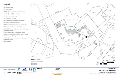
Legend GO: General Office LO: Limited Office SF-2: Single-Family Residence - Standard Lot GO-MU: General Office - Mixed Use GR: Community Commercial CH: Commercial Highway GO MF-2: Multi-Family Residence - Low Density CS: General Commercial Services CS-1: General Commercial Services - Liquor Store CS-V: Commercial Services - Vertical Mixed Use GO CS-1-V-CO: Commercial Services - Vertical Mixed Use Conditional Overlay LO-CO: Limited Office - Conditional Overlay MF-2 GR-V-CO: Community Commercial - Vertical Mixed Use - Conditional Overlay GR-MU-CO: Community Commercial - Mixed Use - Conditional Overlay UNZ - Unzoned SF-2 SF-2 GO-MU LO R E F F U 0 ’ B 0 5 SF-2 LO CS BARTON CREEK GREENBELT MF-4 L O O P 3 6 0 MF-2 UNZ CS-1-V-CO CS-1 GR GR CS U S S T O P O E T R R A PID B GR-V A PIT A L M E T R O M C CS-V D R A V E L U O R B A CS-1-V-CO M A S . L CS CH GO GR Legend: Property Boundary 500’ Buffer Existing Buildings Zoning Districts MF-2 SF-2 GR GR-MU-CO GR-V-CO GR MF-2 SF-3 SF-5 SF-3 GR SF-6 SF-3 CS-1-V CS CS MF-2 LO-CO SF-6 0 200 400 800 EXHIBIT B: BRODIE CONTEXT MAP SUBMITTAL DATE: XX/XX/2022 PUD CASE: C814-2021-076006 BRODIE OAKS REDEVELOPMENT SITE METRICS 37.6 Acres / 1,637,856 Sq. Ft. 56% NSA; 54% GSA 5,750 Sq. Ft. 50 feet Total Site Area Proposed Impervious Cover Minimum Lot Size Minimum Lot Width Minimum Setbacks Front Street Side Yard Interior Side Yard Rear Yard 0 feet 0 feet 0 feet 0 feet LAND USE AREA METRICS Acres Building Cover Impervious Cover* Non- Residential Maximum Hotel Maximum Residential Max. % Max. Sq. Ft. Keys Sq. Ft. Units Sq. Ft. 1,400,000 200 200,000 1,700 1,500,000 11.7 .5% 5,000 -- -- -- -- Max. 95% 25.9 Land Use Area 1 Land Use Area 2 Site Total 37.6 95% 7.5% 56% *Maximum impervious cover is based on Net Site Area (NSA) and will be tracked by site plan in compliance with Exhibit H - Brodie Oaks Redevelopment Phasing Plan. Impervious Cover will be higher on a site-by-site basis. Maximum floor-to-area ratio is not applicable to the Brodie Oaks Redevelopment. L O O P 3 6 0 BARTON CREEK GREENBELT Legend: Property Boundary Private Streets with Public Access Easements Land Use Area 1 Land Use Area 2 U S S T O P O E T R R A PID B A PIT A L M E T R O M C D R A V E L U O R B A M A S . L 0 100 200 400 EXHIBIT C: BRODIE LAND USE PLAN (PAGE 1) SUBMITTAL DATE: XX/XX/2022 PUD CASE: C814-2021-076006 BRODIE OAKS REDEVELOPMENT L O O P 3 6 0 Legend: Property Boundary Private Streets with Public Access Easements Height Zone 1 - 160’ Max Height Zone 2 - 225’ Max Height Zone 3 - 275’ Max Height Zone 4 - 28’ Max BARTON CREEK GREENBELT U S S T O P O E T R R A PID B A PIT A L M E T R O M C D R A V E L U O R B A M A S . L 0 100 200 400 EXHIBIT C: BRODIE LAND USE PLAN (PAGE 2) SUBMITTAL DATE: XX/XX/2022 PUD CASE: C814-2021-076006 BRODIE OAKS REDEVELOPMENT BARTON CREEK GREENBELT 2 0 0 ’ f r o m r o a d w a y m R a H i l l o x C a i o d m u w u n a m t r y : y h 2 e R 8 i o ’ g a h d t w w a i t y h i O n v 2 e 0 r l 0 a ’ y o f m 2 a H i l l 0 x C 0 i o ’ f r o m u u n m t r m t y h R h e i o g a e R h d t o w a g a d y r e w a O a t y e v : r e 5 t r l h a 3 ’ a y n Affordable Housing Commitments ESTABLISHING BASE HEIGHT The base height used to calculate affordable bonus area is based on maximum height allowable under current zoning including overlay zoning districts. The area used to calculate the base has been modified to include whole buildings for simplicity of permitting and administration. HILL COUNTRY AREA HEIGHT COMPENSATION Area where base height is increased Area where base height is decreased Difference 0.3 acres 1.3 acres 1 acre RESIDENTIAL BONUS AREA To the extent any residential buildings exceed the base heights established in this Exhibit C Brodie Land Use Plan (Page 4), the developer shall provide contract commitments and performance guarantees that provide affordable housing meeting or exceeding the requirements of Section 2.5.3 (Requirements for Rental Housing) and Section 2.5.4 (Requirements for Ownership Housing) equal to 10% of the total amount of occupiable square feet which exceeds the established base height. Such calculation shall be made for each building at the time a building permit is issued. PHASING OF RESIDENTIAL BONUS AREA In recognition that some buildings will contain more residential units than others, such obligation may be transferred between buildings as they come on line as long as the number of units never falls below the required obligation. The total residential affordable housing square foot obligation will be tracked on each site plan in accordance with Exhibit H: Brodie Oaks Phasing Plan. L O O P 3 6 0 Legend: Property Boundary Private Streets with Public Access Easements Hill Country Roadway Overlay Boundary Base Height - 28 Feet Base Height - 53 Feet Base Height - 60 Feet N E B L E G SIT E. A D - A L O D N R A F F O U SI N O H S T A U S S T O P O E T R R A PID B A PIT A L M E T R O M C D R A V E L U O R B A M A S . L 0 100 200 400 EXHIBIT C: BRODIE LAND USE PLAN (PAGE 3) SUBMITTAL DATE: XX/XX/2022 PUD CASE: C814-2021-076006 BRODIE OAKS REDEVELOPMENT The fee-in-lieu amount form Phase I and Phase II will be assessed at the time of building permit and tracked on each site plan in accordance with Exhibit H: Brodie Oaks Phasing Plan. NON-RESIDENTIAL BONUS AREA To the extent any non-residential buildings exceed the base height established in this Exhibit C Brodie Land Use Plan (Page 4), the developer shall convey land to Foundation Communities for a standalone affordable housing project built on-site that must: • Include a minimum of 130 family-oriented units with a higher percentage of 3-bedroom units than the site wide average; • Be affordable to a household whose income is between 30 and 60 percent of the median family income in the Austin metropolitan statistical area; • Remain affordable for 40 years from the date a certificate of occupancy is issued; and • Be eligible for federal housing choice vouchers. ASSURANCES AND PHASING OF NON-RESIDENTIAL BONUS AREA In recognition of these facts: • Brodie will be constructed over time; • A stand-alone Foundation Communities project will require additional tax credits and other funding sources for construction and operation that are likely but not certain and not within this developers control; and • The best site for a stand-alone affordable housing project is located in Phase II of the development, adjacent to the planned neighborhood park, along the South Lamar frontage, and adjacent to the planned transit stop. The affordable housing requirement attributed to non- residential square footage may be constructed no later than 5 years after the first building permit in Phase II is granted a Certificate of Occupancy. In the event land has not been conveyed to Foundations Communities and a project is not in process by this time the developer will provide the amount established under Section 2.5.6 (In Lieu Donation) for each square foot of non-residential bonus square footage above the baseline to the Affordable Housing Trust Fund to be used for producing or financing affordable housing, as determined by the Director of the Neighborhood Housing and Community Development Department. EXHIBIT C: BRODIE LAND USE PLAN (PAGE 4) SUBMITTAL DATE: XX/XX/2022 PUD CASE: C814-2021-076006 BRODIE OAKS REDEVELOPMENT Notes Compliance will meet all aspects of the fire code and Wildland-Urban Interface, (WUI) Code, Ordinance No. 20200409-040 and may include the provision of defensible space within the parks identified on Exhibit D: Brodie Parks and Open Space which separate the developed area of the site from the existing greenbelt by a minimum of 88-feet and separate any buildings by a minimum of 142-feet at the closest point. Enhanced fire resistant construction standards for the buildings located in proximity to the fire hazard area may also be employed to meet the code. All compliance will be demonstrated on a fire protection plan for the proposed development at the time of subdivision, site plan, and building permits as applicable. The development will meet Section 402.1.1 Access as demonstrated in Exhibit E: Brodie Transportation Plan. BARTON CREEK GREENBELT Parkland to be managed as an area of defensible space. Slopes greater than 10% Minimum 88-feet to the edge of the internal street and access area. Minimum 142-feet to the closest building. L O O P 3 6 0 Legend: Property Boundary Private Streets with Public Access Easements Height Zone 1 - 160’ Max Height Zone 2 - 225’ Max Height Zone 3 - 275’ Max Height Zone 4 - 28’ Max U S S T O P O E T R R A PID B A PIT A L M E T R O M C D R A V E L U O R B A M A S . L 0 100 200 400 EXHIBIT C: BRODIE LAND USE PLAN (PAGE 5) SUBMITTAL DATE: XX/XX/2022 PUD CASE: C814-2021-076006 BRODIE OAKS REDEVELOPMENT Hill Country Roadway Overlay Hill Country Roadway Overlay Requirements shall apply differently to Land Use Area 1 (LU1) and Land Use Area 2 (LU2) as indicated in the Hill Country Roadway Overlay (HCRO) standards chart in Exhibit C: Land Use Plan (page 5). TREE TABLE TOTAL LOW SUITABILITY ADJUSTED TOTAL* PRESERVED % PRESERVED Native Heritage Trees (24” and above) Native Protected Trees (19”- 23’11”) Native Regulated Trees (8” - 18’11”) Small Native Regulated Trees (6” or more; and Tree clusters) 12 2 51 1 0 0 12 1 12 2 39 0 12 2 32 0 100% 100% 82% - Restored Hill Country and Native Prairie landscape (2 acres) LU2 T r e p l a e n c t i n o m g p a r e e n a s . a t i o n 1 0 0 ’ R o a d w a y V e g e t a t i v e B u f f e r H i l l C o u n t r y R o a d w a y O v e r l a y E x i s t i n g R e t a i n i n g W a l l t o b e r e m o v e d BARTON CREEK GREENBELT LU1 L O O P 3 6 0 Legend: Property Boundary Private Streets with Public Access Easements Hill Country Roadway Overlay (15.7 acres) Native Preserved Trees Native Removed Regulated trees Non-Native Preserved Trees Land Use Area 1 (8.4-acres) (within HCRO) Land Use Area 2 (7.5-acres) (within HCRO) U S S T O P O E T R R A PID B A PIT A L M E T R O M C D R A V E L U O R B A M A S . L 0 100 200 400 EXHIBIT C: BRODIE LAND USE PLAN (PAGE 6) SUBMITTAL DATE: XX/XX/2022 PUD CASE: C814-2021-076006 BRODIE OAKS REDEVELOPMENT NOTES The Brodie PUD may include temporary parking areas on cleared land within Land Use Area 1 while the site is awaiting full buildout of each phase. These parking areas will not be subject to this code section. No permanent surface parking lots are proposed in the Brodie PUD. The existing berm on Loop 360 will remain and provides screening of the park road. Buildings in LU1 will not be screened. Notes HILL COUNTRY ROADWAY OVERLAY Hill Country Roadway Overlay Standards Table HCRO STANDARDS LU1 LU2 Floor-To-Area Ratio (25-2-1122) Modified Modified Construction on Slopes (25-2-1123) Meets Modified Building Height (25-2-1124) Modified Exceeds Location of On-Site Utilities (25-2-1125) Meets Meets Building Materials (25-2-1126) Modified Meets Native Trees (25-2-1022) Meet Exceed Roadway Vegetative Buffer (25-2-1023) Modified Exceed Natural Area (25-2-1025) Modified Modified NOTES See the site metrics table on the Land Use Exhibit. FAR is not being regulated for the Brodie Site. The existing park road is constructed on slopes that exceed 15 percent gradient for a short portion of the roadway within the property and for a longer distance off-site. Due to the location of this road within the Balcones Canyon Land Preserve no modifications are proposed to the road where it enters the site. The Brodie PUD is in a high intensity area and thus is restricted to 28’ in height within 200’ of the ROW and 53’ if further than 200’ from the ROW. The Brodie PUD Height exhibit shows that all land within Land Use Area 2 will be restricted to 28’ providing enhanced views of the Hill Country. Height has been modified in Land Use Area 1 in proximity to the intersection of Loop 360 and S. Lamar Blvd. All utilities will be underground No buildings area proposed in Land Use Area 2. Building materials will meet the requirements of the HCRO on the ground floor only in Land Use Area 1. All Heritage and Protected Trees within the HCRO are being preserved. Eighty percent (80%) of the inches from native trees and small native trees less than 19” and determined as suitable for preservation by the submitted arborist report within the HCRO area are being preserved. Any native trees that are removed from Land Use Area 1 will be compensated for in Land Use Area 2 at a mitigation rate of 60%. The priority tree planting area within Land Use Area 2 for compensating trees will be within and adjacent to the highway vegetative buffer area. All buildings and impervious cover with the exception of the existing park road which is necessary for site access will be removed from Land Use Area 2. The vegetative area in Land Use Area 2 will extend all the way back to the edge of the property and the Barton Creek Greenbelt and be dedicated as parkland. Public access and views will be restored in Land Use Area 2. The project is removing all buildings and surface parking lots from Land Use Area 2 representing over 45% of the HCRO area. This area will be vegetated and dedicated as City of Austin Parkland therefore some of the area will be used for recreation and not meet the HCRO revegetation requirements. A minimum of two acres or 12% of Land Use Area 2 will be revegetated utilizing the HCRO standard with an increased commitment to 1/3 the standard density from the code required 1/4 of the standard density and a native prairie standard as identified on this exhibit. HCRO STANDARDS LU1 LU2 Parking Lot Medians (25-2-1026) Modified Meet Visual Screening (25-2-1027) Modified Meet HCRO Revegetation Standards 1. One acre within LU2 shall be re-vegetated according to the HCRO revegetation criteria included in Appendix A of the Environmental Criteria Manual. The Brodie Oaks Site was developed prior to the Hill Country Roadway Overlay Ordinance going into effect and meets the criteria for Low Density revegetation and requires restoration at 1/4 the standard density. This PUD will increase the density of revegetation to 1/3 the standard density. 2. One acre within LU2 shall be re-vegetated according to a native prairie standard as indicated below: Goal: Establish a native prairie ecology. The desired outcome is to have a herbaceous understory reflective of native prairie established within 12 - 18 months of seed application. Source: Seed Application: 50/50 mix of Riparian Recover mix and Native Prairie mix of net acre of native prairie area. Time of Year Application: October 1st -December 15th or March 15th - May 15th. Fall preferred. Acceptance: At two years from Implementation: - 80% groundcover/vegetative coverage. EXHIBIT C: BRODIE LAND USE PLAN (PAGE 7) SUBMITTAL DATE: XX/XX/2022 PUD CASE: C814-2021-076006 BRODIE OAKS REDEVELOPMENT • Medical Office – not exceeding 5,000 sq. ft. gross PARKLAND DEDICATION 1. Parkland dedication shall be satisfied in accordance with Exhibit D- Brodie Oaks Redevelopment Parks and Open Space Plan. Notes LAND USES Use Areas 1. 1. The following uses are permitted uses within Land Residential Uses • Bed & Breakfast (Group 1) • Bed & Breakfast (Group 2) • Condominium Residential • Group Home, Class I (General) • Group Home, Class I (Limited) • Group Home, Class II • Multifamily Residential • Townhouse Residential • Short-Term Rental (Types 1 and 3) Commercial Uses • Administrative and Business Office • Art Gallery • Art Work Shop • Automotive Sales • Automotive Rentals • Automotive Repair Services • Business or Trade School • Business Support Services • Cocktail Lounge (up to 25,000 sq. ft. gross floor area by-right; A CUP is required for any additional gross floor area) • Commercial Off-Street Parking • Communications Services • Consumer Convenience Services • Consumer Repair Services • Convenience Storage • Electronic Prototype Assembly • Electronic Testing • Financial Services • Food Preparation • Food Sales • General Retail Sales (Convenience) • General Retail Sales (General) • Hotel-Motel • • • Kennels • Laundry Services • Liquor Sales (up to 25,000 sq. ft. gross floor area) • Medical Offices – exceeding 5,000 sq. ft. gross Indoor Entertainment Indoor Sports and Recreation floor area floor area • Off-Site Accessory Parking • Outdoor Entertainment • Outdoor Sports and Recreation • Pedicab Storage and Dispatch • Personal Improvements Services • Personal Services • Pet Services • Plant Nursery • Printing and Publishing • Professional Office • Recreational Equipment Maint. & Stor. • Recreational Equipment Sales • Research Assembly Services • Research Services • Restaurant (General) • Restaurant (Limited) • Service Station • Software Development • Theater • Vehicle Storage • Veterinary Services Industrial Uses • Custom Manufacturing Agricultural Uses • Community Garden • • Urban Farm Civic Uses • Administrative Services • Camp • Club or Lodge • College and University Facilities • Communication Service Facilities • Community Events • Community Recreation (Private) • Community Recreation (Public) • Congregate Living • Convalescent Services • Counseling Services • Cultural Services • Day Care Services (Commercial) • Day Care Services (General) • Day Care Services (Limited) • Family Home • Hospital Services (General) • Hospital Services (Limited) • Local Utility Services Indoor Crop Production • Major Utility Facilities • Maintenance and Service Facilities • Park and Recreation Services (General) • Park and Recreation Services (Special) • Private Primary Educational Facilities • Private Secondary Educational Facilities • Public Primary Educational Facilities • Public Secondary Educational Facilities • Religious Assembly • Safety Services • Telecommunication Tower 2. The following uses are permitted uses within Land Use Area 2. Commercial Uses • Commercial Off-Street Parking • Outdoor Entertainment (See note 4) • Outdoor Sports and Recreation • Pedicab Storage and Dispatch • Recreational Equipment Maint. & Stor. Agricultural Uses • Community Garden Civic Uses • Camp • Community Events • Community Recreation (Private) • Community Recreation (Public) • Cultural Services • Park and Recreation Services (General) • Park and Recreation Services (Special) • Religious Assembly 3. A site can cross a public or private street or right-of- way. 4. A site plan for the construction of an amphitheater, pavilion or other outdoor venue located in Land Use Area 2 that is associated with a commercial, civic, or residential use and designed for a maximum occupancy of 2,000 people may be approved administratively. Larger amphitheaters will require the approval of a CUP. 5. The temporary sale of alcohol associated with an event in Land Use Area 2 may be allowed subject to approval by the City of Austin Parks and Recreation Department special event permit and applicable TABC permitting. EXHIBIT C: BRODIE LAND USE PLAN (PAGE 8) SUBMITTAL DATE: XX/XX/2022 PUD CASE: C814-2021-076006 BRODIE OAKS REDEVELOPMENT Restored Hill Country and Native Prairie landscape (2 acres) Secondary Trail Head Primary Trail Head BARTON CREEK GREENBELT Trailhead Overlook Park Central Green Neighborhood Park U S S T O P O E T R R A PID B A PIT A L M E T R O M C Name Overlook Trailhead Park Central Green Neighborhood Park Total % of Site (37.6 acres) Total Acres 8.1 Open Space Yes Restored Landscape Yes (2 acres) Dedicated Parkland Yes Credited Acres* 6.7 1.3 2.2 Yes Yes Yes Yes 1.3 1.9 11.6 11.6 30.8% 30.8% 2.0 5.3% 11.6 30.8% 9.9 26.3% PARKLAND CREDIT CALCULATIONS d e r e b m u c n e n U 1.0 .7 1.8 y t i l a u Q r e t a W d n a m e t s y S * s t n e m e s a E 5.5 .6 .4 % 0 1 > s e p o S l 1.4 0 0 s e r c A l a t o T 8.1 1.3 2.2 i l ; n a p d o o F l F E C ; Z Q W C l a t o T d e r e b m u c n E 0 0 0 7.1 .6 .5 s e r c A d e t i d e r C ) m u m n M i i ( 4.6 1.0 2.0 s d n o P .2 0 0 Overlook Trailhead Park Central Green Neighborhood Park 0 7.6 8.1 50% 3.3* 100% 11.6 3.5 50% 50% 50% .1 .7 Percent Credited Total * The size and location of easements associated with the SOS water quality system including sub-surface ponds and reirrigation areas will be determined at the time of dedication and after execution of the parks maintenance agreement. Easement areas represented in the parkland credit calculation table represent the maximum amount of acres needed and include accommodation for an additional 2.5 acres of reirrigation area over the anticipated 3 acres in the event that watershed protection department requires additional water quality measures during extreme storm frequencies. Unlike the standard retention/irrigation system mentioned above where reirrigation occurs after every rain event, this system would only be used after extreme events. In comparison, the standard retention/irrigation system would irrigate after every rain event, whereas the rainwater system would only irrigate 0-2 times/year. All re-irrigation areas will be designed as restored habitat with trails or will be designed to allow for some recreation. Subsurface ponds will allow full use on the surface and may be credited up to 100%. Exact credit assigned at dedication must generally comply with the Standards for Dedicated Parkland and the Parkland Dedication Operating Procedures, as amended but at no time will they be credited at less than 50%. Notes 1. Parkland must generally comply with the Standards for Dedicated Parkland and the Parkland Dedication Operating Procedures, as amended. 2. Any surface pond or wetland area will be designed as an amenity in accordance with the Parkland Dedication Operating Procedures, as amended L O O P 3 6 0 Legend: Property Boundary Private Streets with Public Access Easements Parkland Dedicated to the City of Austin CEF Slopes above 10% Pedestrian Connection Shared Use Path D R A V E L U O R B A M A S . L 0 100 200 400 EXHIBIT D: BRODIE PARKS AND OPEN SPACE PLAN (PAGE 1) SUBMITTAL DATE: XX/XX/2022 PUD CASE: C814-2021-076006 BRODIE OAKS REDEVELOPMENT OPEN SPACE The open space required to meet the PUD Tier I (Sec.2.3.1c) “superior development” standard is 10 percent of the residential tracts and 20 percent of non-residential tracts. The Brodie Oaks Redevelopment is a mixed use development consisting of both residential and non-residential uses and uses the commercial designation. Mixed Use developments are classified as non-residential and use the 20 percent: • Developed Area: 26.0 acres • Open space required to meet Tier I: 5.2 acres (20% of 26.0 acres) PARKLAND DEVELOPMENT CO-LOCATING RE-IRRIGATION The Brodie Oaks Redevelopment will develop, operate, and maintain all open space on site in accordance with an executed park maintenance agreement for the site. Where re-irrigation is co-located with park amenities one of the following mitigation measures will be used to ensure full use of the amenity. Brodie will develop 50 parking spaces. Parking spaces will be reserved for park users and provided in phase 1 as indicated in Exhibit H: Brodie Phasing Plan. from the amenity. • Directional Spray - The re-irrigation system will be designed so that it can be directed away The Brodie Oaks Redevelopment will strive towards achieving SITES Silver Certification for Parks. • Final re-irrigation operation details will be reviewed by PARD and require PARD approval The Brodie Oaks Redevelopment is committing to exceed the Parkland Development Fee in effect at the time of site plan by $700 per unit for both residential and hotel units. • Total open space provided: 11.6 acres (45% of 26.0 acres) This fee may be used for the following within the parkland dedicated with this PUD.: The open space required to meet the requirements in PUD Tier II (Sec.2.4) is open space at least 10 percent above the requirements of Section 2.3.1.A. (Minimum Requirements). Alternatively, within the urban roadway boundary established in Figure 2 of Subchapter E of Chapter 25-2 (Design Standards and Mixed Use), provide for proportional enhancements to existing or planned trails, parks, or other recreational common open space in consultation with the Director of the Parks and Recreation Department. • Required and allowed parkland amenities listed in the parkland amenities table; • All Shared Use Paths (SUP) and trails within the parks; Landscaping and planting within the parks; DOG PARK OR DOG RUN Irrigation of landscaping and planting materials within the parks; TRAILHEAD AND CONNECTION TO BARTON CREEK GREENBELT The project is currently working with local organizations like the Hill Country Conservancy, Save Barton Creek Association, and Austin Parks Foundation to explore how the project can support the construction and ongoing maintenance of a trail connection to the Barton Creek and regional Violet Crown Trail systems. Any dog run or dog park will be designed with PARD and WPD approval. All Stormwater from the Park areas will be captured into the subsurface ponds as such there no stormwater is directly discharged off site of any developed areas. The dog park will not be co-located with any re- irrigation area. • Developed Area: 26.0 acres Lighting installed within the parks; • Open space required to meet Tier II: 7.8 acres (30 percent of 26 acres) Park signage and wayfinding to include interpretive signage within the parks; • Total open space provided: 11.6 acres (45% of 26.0 acres) Park security facilities and amenities; and / or • • • • • • PARKLAND According to the parkland dedication operating procedures (Sec.14.3.9B) to be considered “superior development,” land proposed for dedication must: 1. Include at least 10.4 credited acres per 1,000 residents, 2. Be developed in accordance with a plan approved by PARD; and 3. Be dedicated to a governmental entity. Brodie is proposing to meet this requirement with the following parkland dedication. • • • Total Parkland Required: 29.6 acres Total Land Provided (minimum): 7.6 acres (See Parkland Credit Calculations Table on previous sheet.) Total Parkland Fee-in-lieu: The balance between required and dedicated parkland will be satisfied as a fee-in-lieu of dedication. The installation of wet or dry utilities installed to service park facilities. The Brodie Oaks Redevelopment is committing to develop a minimum of three amenities per park area. As indicated in the table below some amenities are required while others are optional. Final park amenities and designs must be approved by PARD, and additional amenities not listed on the table may be added with mutual approval between the developer and PARD. PARKLAND AMENITIES LIST Co-located with Re-irrigation Yes Overlook / Trailhead Central Neighborhood Seating Trailhead Trail Connections Restored Landscape Dog Run Playground Cyclist Amenities Sidewalk or Shared-use Path Volleyball Courts Markets Nature Playground Trails and Pathways Interpretive Signage Dedicated Parking Area Playfields Outdoor Fitness Station Open Lawn Social Games Interactive Water Feature Shade Sail / Structure / Pavilion Restrooms Legend: R = Required Amenity A = Allowed Amenity Yes Yes No No Yes Yes No Yes Yes Yes Yes No Yes Yes Yes No No No No A A R A A A A A A A A A R A R A R A A A R A A A A A A A A A A A A A A A A R EXHIBIT D: BRODIE PARKS AND OPEN SPACE PLAN (PAGE 2) SUBMITTAL DATE: XX/XX/2022 PUD CASE: C814-2021-076006 BRODIE OAKS REDEVELOPMENT Notes 1. The Brodie PUD is proposing the construction of a shared use path to connect Brodie to the Barton Creek Plaza. The existing Park Street A is constructed within a 40’ easement and located within COA Parkland and the Balcones Canyonland Preserve. No increase in impervious cover is permitted within the preserve. Based on this the shared use path is proposed to be located within TxDOT ROW and will be subject to approval by TxDOT at the time of permitting. 2. The shared use path will remain in TxDOT ROW until the first intersection within the Brodie PUD where a safe crossing can be provided. 3. The shared use path and cycle track will connect to S. Lamar Blvd at the northern most entrance to the project. 4. Electric Vehicle Charging Stations will be provided. 5. Gated roadways are prohibited. 6. All tree zones are a minimum of 7’ wide and will include trees a minimum of 3 inches in diameter when measured 6 inches above the root flare at the time of planting. Legend: 7. Where the buffer and bike lane are adjacent to the street edge, they will be constructed of reinforced concrete with integral terracotta coloring to allow for deployment of outriggers for fire ground setup. 8. All internal drives shall remain private; however, the drives have been designed to adhere to the Transportation Criteria Manual, Section 2 where possible. Towards Barton Creek P a r k S t r e e t A a il y T r P r d r i m a a H e BARTON CREEK GREENBELT r y d a a e d n o a il H S c e T r P a r k S t r e e t B r n a l u l a t u o t e 2 I n r c o e t C i r R L O O P 3 6 0 e t C a r k S tr e P I n t e r n a l C i r c u l a t o r R o u t e 1 pro v e m e nts to S. L a m ar C orrid or I m P O T S S O R T P I D B U E A L M R O A R C P I T T E A M D R A V E L U O R B A M A S . L Property Boundary Internal Circulator Route 1 Internal Circulator Route 2 Park Street A Park Street B Park Street C Shared Use Path Cycle Track Side walk Parkland Trail Angled Parking Cap-Metro Bus Stop Pedestrian Crossing EXHIBIT E: BRODIE TRANSPORTATION PLAN (PAGE 1) SUBMITTAL DATE: XX/XX/2022 PUD CASE: C814-2021-076006 BRODIE OAKS REDEVELOPMENT ICR 2 ICR 1 Notes 1. This ICR section is a typical section. Parallel parking on both sides of the street will be included for approximately 60% of the street extent. Where the street intersects other streets parallel parking may be dropped from one side of the street or the other at various points. The back of curb section will remain consistent along the entire ICR. 2. Where the buffer and bike lane are adjacent to the street edge, they will be constructed of reinforced concrete with integral terracotta coloring to allow for deployment of outriggers for fire ground setup. 3. All tree zones along the ICR are a minimum of 7’ wide when an additional row of trees is provided within the section. This additional row of trees increases the total tree zone space from a required 16’ to 21’ for the section. Trees planted within the ICR must be at least 6 feet in height and have a trunk diameter of three (3) inches measured 6 inches above the ground at the time it is planted. Legend: SUP: Shared Use Path CZ: Clear Zone TZ: Tree Zone BL: Bicycle Lane TL: Travel Lane B: Buffer P: Parking FZ: Frontage Zone INTERNAL CIRCULAR ROUTE 1 Typical Section, varies with Parking (Modified Street Level 2, Fig. 2-18 of the TCM) INTERNAL CIRCULAR ROUTE 2 With Shared Used Path (Modified Street Level 2, Fig. 2-18 of the TCM) EXHIBIT E: BRODIE TRANSPORTATION PLAN (PAGE 2) SUBMITTAL DATE: XX/XX/2022 PUD CASE: C814-2021-076006 BRODIE OAKS REDEVELOPMENT ICR 3 Notes 1. Where the buffer and bike lane are adjacent to the street edge, they will be constructed of reinforced concrete with integral terracotta coloring to allow for deployment of outriggers for fire ground setup. 2. All tree zones along the ICR are a minimum of 7’ wide when an additional row of trees is provided within the section. This additional row of trees increases the total tree zone space from a required 16’ to 21’ for the section. Trees planted within the ICR must be at least 6 feet in height and have a trunk diameter of three (3) inches measured 6 inches above the ground at the time it is planted. Legend: SUP: Shared Use Path CZ: Clear Zone TZ: Tree Zone BL: Bicycle Lane TL: Travel Lane B: Buffer P: Parking FZ: Frontage Zone INTERNAL CIRCULAR ROUTE 3 With Angled Parking (Modified Street Level 2, Fig. 2-18 of the TCM) EXHIBIT E: BRODIE TRANSPORTATION PLAN (PAGE 3) SUBMITTAL DATE: XX/XX/2022 PUD CASE: C814-2021-076006 BRODIE OAKS REDEVELOPMENT A B Notes 1. The Brodie PUD is proposing the construction of a shared use path to connect Brodie to the Barton Creek Plaza. The existing Park Street A is constructed within a 40’ easement and located within COA Parkland and the Balcones Canyonland Preserve. No increase in impervious cover is permitted within the preserve. Based on this the shared use path is proposed to be located within TxDOT ROW and will be subject to approval by TxDOT at the time of permitting. 2. The shared use path will remain in TxDOT ROW until the first intersection within the Brodie PUD where a safe crossing can be provided. 3. The shared use path and cycle track will connect to S. Lamar Blvd at the northern most entrance to the project. 4. Park Street B, per TCM Figure 2-16, is applicable for buildings fronting street 4 stories or more in height. Bulb-outs for fire deployment zones. Additional speed management devices to be placed at maximum 300’ spacing to intersection or another device mid block. 5. Buffer and bike lane to be constructed of reinforced concrete with integral terracotta coloring to allow for deployment of outriggers for fire ground setup. Legend: SUP: Shared Use Path CZ: Clear Zone TZ: Tree Zone BL: Bicycle Lane TL: Travel Lane B: Buffer P: Parking FZ: Frontage Zone PARK STREET A PARK STREET B (Modified Street Level 1, Fig. 2-16 of the TCM) EXHIBIT E: BRODIE TRANSPORTATION PLAN (PAGE 4) SUBMITTAL DATE: XX/XX/2022 PUD CASE: C814-2021-076006 BRODIE OAKS REDEVELOPMENT Notes 1. The Park Street and associated shared use path connects the Brodie Oaks Redevelopment and Barton Creek Trailhead to the Barton Creek Plaza office park. 2. Buffer and bike lane to be constructed of reinforced concrete with integral terracotta coloring to allow for deployment of outriggers for fire ground setup. 3. Park Street C, per TCM Figure 2-16, is applicable for buildings fronting street 4 stories or more in height. Bulb-outs for fire deployment zones. Additional speed management devices to be placed at maximum 300’ spacing to intersection or another device mid block. C Legend: SUP: Shared Use Path CZ: Clear Zone TZ: Tree Zone BL: Bicycle Lane TL: Travel Lane B: Buffer P: Parking FZ: Frontage Zone PARK STREET C (Modified Street Level 1, Fig. 2-16 of the TCM) EXHIBIT E: BRODIE TRANSPORTATION PLAN (PAGE 5) SUBMITTAL DATE: XX/XX/2022 PUD CASE: C814-2021-076006 BRODIE OAKS REDEVELOPMENT Notes 1. Applicant will construct all back of curb improvements compliant with the South Lamar Blvd 2016 Mobility Bond plan requirements and dedicate any space, right-of-way, or easement, necessary for such improvements. SOUTH LAMAR BOULEVARD EXHIBIT E: BRODIE TRANSPORTATION PLAN (PAGE 6) SUBMITTAL DATE: XX/XX/2022 PUD CASE: C814-2021-076006 BRODIE OAKS REDEVELOPMENT Notes Active Edge 1. An active edge imposes specific land use and design requirements for development along S. Lamar Blvd. It requires building facades to be located adjacent to or near to the clear zone. 2. Design elements of an active edge include the use of at least one of the following frontage elements: • A building where the first 30’ from the frontage of S. Lamar is designed to accommodate an active use in the future. Active uses include commercial, retail, restaurant, entertainment, and lobbies for civic, hotel, or multi-family uses. • Building entrances oriented towards S. Lamar Blvd., • Window treatments oriented towards S. Lamar Blvd., • Awnings and canopies, • • • Plaza spaces, Screened parking, or Public art. M i d - B l o c k C r o s s i n g e g d c tiv e E % A 5 2 0% Active Edge D R A V E L U O R B A M A S . L M i d - B l o c k C r o s s i n g e E c tiv e g d % A 5 7 p R O u s S t o T E p it al M p i d B e tr o r a a C M g e 2 5 % A ctiv e E d Legend: C a pital M E T R O M etrora pid B us Sto p Property Boundary Private Streets with Public Access Easements Landscape Zone Bike Path Tree Zone Sidewalk Building Frontage Survey Line Capital METRO Metrorapid Bus Stop Crosswalk Pedestrian Oriented Uses EXHIBIT E: BRODIE TRANSPORTATION PLAN (PAGE 7) SUBMITTAL DATE: XX/XX/2022 PUD CASE: C814-2021-076006 BRODIE OAKS REDEVELOPMENT Notes 1. The Brodie PUD will fully comply with the SOS pollutant removal requirements. This is being accomplished through two separate methods. The first method will capture stormwater runoff from the site (excluding the rooftops of the buildings) and will not deviate from the City of Austin requirements and meet all aspects of the Environmental Criteria Manual for Retention/Irrigation Systems. The second method will be Rainwater Harvesting where the water will be used for beneficial reuse such as cooling tower make-up water and landscape irrigation, as further described in the PUD Code Modifications. 2. Infiltration testing will be provided as part of the full engineering design to be submitted for permit. Engineered soils may be considered to improve infiltration. 3. This project is subject to the Void and Water Flow Mitigation Rule (COA ECM 1.12.0 and COA Item No. 658S of the SSM) provision that all trenching greater than 5 feet deep must be inspected by a geologist (Texas P.G.) or a geologist’s representative. BARTON CREEK GREENBELT 1 5 ’ S S E S M T T M S S E 5 ’ S 1 2 0 ’ S S E S M T 1 5 ’ S S E S M T 0 ’ S S E S M T 2 1 5 ’ S S E S M T T M S S E 5 ’ S 1 1 5 ’ S S E S M T U S S T O P O E T R R A PID B A PIT A L M E T R O M C L O O P 3 6 0 Legend: Property Boundary Private Streets with Public Access Easements Rainwater Harvesting Tank Subsurface Ponds Proposed Stormsewer Overflow Proposed Stormsewer Roof Collection Proposed Stormsewer Site Runoff Collection D R A V E L U O R B A M A S . L 0 100 200 400 EXHIBIT F: BRODIE WATER QUALITY AND ENVIRONMENT (PAGE 1) SUBMITTAL DATE: XX/XX/2022 PUD CASE: C814-2021-076006 BRODIE OAKS REDEVELOPMENT Notes 1. The CEF setbacks for S-1 and S-2 have been adjusted. The CEF area removed from our site was 8,443 sf and we added 8,496 sf. to the CEF area. 2. The project is requesting a modification to the CEF buffer around Airman’s cave. According to analysis performed by Nico Hauwert (Airman’s Cave Hydro Study 2021), the cave is approximately 140’ below the surface. The project is requesting an encroachment into the CEF buffer for the purpose of subsurface parking garages or ponds and structural supports of up to 80’ with the condition that at minimum 20’ of Del Rio Clay remains between any encroachment and the vertical extent of the cave. No open cut below 660’ AMSL or structural borings to below 630’ AMSL. Any groundwater encountered during boring, excavation, or any other construction activities will be disposed of according to all local, state, and federal guidelines 3. Perimeter fencing must be installed at the outer edge Critical Environmental Feature (CEF) setback area for all point recharge features. (CEF - F1 on ERI) Fencing must meet or exceed the criteria of COA Item No. 701S of the SSM. At least one four-foot wide, lockable access gate must be provided [LDC 25-8-281(C)(4)]. L O O P 3 6 0 4. The presence of a Critical Environmental Feature on or near a property may affect development. All activities within the Critical Environmental Features (CEF) setback must comply with the City of Austin Code and Criteria. The natural vegetative cover must be retained to the maximum extent practicable; construction is prohibited; and wastewater disposal or irrigation is prohibited. 5. This project is located within the Edwards Aquifer Recharge Zone as defined by TCEQ Texas Administrative Code (30 TAC) Chapter 213.” 6. The location of the CEF buffer for Airman’s Cave will be determined based on the most up to date information from the Balcones Canyonlands Preserve. Legend: Property Boundary Private Streets with Public Access Easements Airman’s Cave (1995) Airman’s Cave (1974) CEF 150 feet CEF Buffer BARTON CREEK GREENBELT Wetland CEF 8,496 SF CEF AREA ADDED 8,443 SF CEF AREA REMOVED U S S T O P O E T R R A PID B A PIT A L M E T R O M C D R A V E L U O R B A M A S . L 0 100 200 400 EXHIBIT F: BRODIE WATER QUALITY AND ENVIRONMENT (PAGE 2) SUBMITTAL DATE: XX/XX/2022 PUD CASE: C814-2021-076006 BRODIE OAKS REDEVELOPMENT Sherwood Forest Poetry Passage Key Plan based on 1995/1996 survey + 13 ft approx 0 Ft (Ground level) - 18 ft appox - 65 ft appox - 85 ft appox t f 0 0 3 t f 5 3 2 - 120 ft appox - 150 ft appox - 175 ft appox - 225 ft appox - 287 ft appox + 5 ft approx 0 Ft (Ground level) - 28 ft appox -72 ft appox - 92 ft appox t f 0 0 3 t f 5 3 2 - 130 ft appox - 160 ft appox - 185 ft appox - 185 ft appox - 295 ft appox Leached and Collapsed Members, Edwards Group Airman’s cave Section at Poetry Passage based on 1995/1996 survey ) L G m o r f ( x o r p p a t f 6 3 1 ) L G m o r f ( x o r p p a t f 5 4 1 Buda Limstone, Washita Group 24075 Sf CEF area removed Modified CEF buffer 20 ft Del Rio Clay, Washita Group Georgetown Limestone, Washita Group Regional Dense Members, Edwards Group Grainstone Members, Edwards Group Kirschberg Member Buda Limstone, Washita Group 22340 Sf CEF area removed Modified CEF buffer 20 ft Del Rio Clay, Washita Group Georgetown Limestone, Washita Group Leached and Collapsed Members, Edwards Group Regional Dense Members, Edwards Group Grainstone Members, Edwards Group Kirschberg Member Airman’s cave Section at Sherwood Forest based on 1995/1996 survey Lateral Section of the Airman’s cave EXHIBIT F: BRODIE WATER QUALITY AND ENVIRONMENT (PAGE 3) SUBMITTAL DATE: XX/XX/2022 PUD CASE: C814-2021-076006 BRODIE OAKS REDEVELOPMENT BARTON CREEK GREENBELT T r a n A s r p e l a a n t Proposed CEF n t n s p la A r e a T r a Tra n s pla n t A re a Notes 1. Brodie has committed to a tree health and maintenance plan for all preserved or relocated trees. TREE TABLE TOTAL RELOCATED PRESERVED IN PLACE REMOVED TREES (ADJUSTED*) ADJUSTED* TOTAL PRESERVED** (%) Heritage (24” and up) 25 19 6 0 25 100% 10 43 23 Protected (19”- 23’11”) Regulated (8” - 18’11”) * The Arborist Report submitted with the PUD application indicates which trees are not suitable for preservation. These trees have been removed from the adjusted numbers in this chart. ** The percent preserved utilizes the adjusted total. 79% 77% 171 101 136 42 31 9 4 TREE # TYPE SIZE 20 LO 356 23.5 LO 14233 25 LO 14234 19 LO 14235 18 LO 14236 15 LO 14237 20 LO 14238 23.7 LO 14239 34.2 LO 14240 LO 14241 14 B. Pear12 14242 19 LO 14243 17 LO 14244 13 LO 15701 12 LO 15702 13 LO 15703 13 LO 15704 15 LO 15705 15 LO 15706 15 LO 15707 15 LO 15708 13 LO 15709 16 LO 15710 16 LO 15711 14 LO 15712 11 LO 15713 13 LO 15714 11 LO 15715 12 LO 15716 13 LO 15717 13 LO 15718 10.5 LO 15719 14 LO 15720 16 LO 15721 CRM 16 15722 18 LO 15723 16 LO 15725 13 LO 15727 10.5 LO 15728 14.5 LO 15730 20.4 LO 15731 25.4 LO 15732 20.1 LO 15733 15.4 LO 15734 11.7 LO 15735 16 LO 15736 39.6 LO 15738 45.6 LO 15739 LO 15740 61 B.Pear 18.7 15741 20.5 LO 15808 18.7 LO 15809 LO 15810 16 BUM 14 15811 BUM 13.5 15812 CRM 22.7 15813 LO 15814 LO 15815 LO 15817 LO 15818 LO 15819 17 18.7 20.8 8.7 8.5 TREE # TYPE SIZE LO 15820 LO 15821 LO 15822 LO 15823 LO 15824 LO 15825 LO 15826 LO 15827 LO 15828 LO 15829 LO 15830 LO 15831 LO 15832 LO 15833 LO 15834 LO 15835 LO 15836 LO 15837 LO 15838 LO 15839 LO 15840 LO 15841 LO 15842 LO 15843 LO 15844 LO 15845 LO 15846 LO 15847 LO 15848 LO 15849 LO 15850 LO 15851 LO 15852 LO 15853 LO 15854 LO 15855 LO 15856 LO 15857 LO 15858 LO 15859 LO 15860 LO 15861 LO 15862 LO 15863 LO 15864 LO 15865 LO 15866 LO 15867 LO 15869 LO 15870 LO 15871 LO 15872 LO 15873 LO 15874 LO 15875 LO 15876 LO 15877 LO 15878 LO 15879 LO 15880 LO 15881 9.5 28 20 23 18 26.3 14.5 20.5 9 15 11.4 11 13 20 20.6 12.7 18.5 12.7 13.6 23.1 11.9 9.8 21 12.8 22.8 13.8 12.4 13 23.7 17.8 23.9 11.7 13 16 16 18 13 41 13 22 17 10 18 27.2 25.3 13 19.5 12.7 22.3 23 25.7 16 20 27.3 14 11.4 23 11 20 21 17 15 19.8 15.5 17 13.6 15.8 22.1 17 21.5 15.5 19 17.5 17.9 16 16 19 16 21 39.4 TREE # TYPE SIZE LO 15882 LO 15883 LO 15884 LO 15885 LO 15886 LO 15887 LO 15888 LO 15889 LO 15890 LO 15891 LO 15892 LO 15893 LO 15894 LO 15895 LO 15896 CE 15897 LO 15898 LO 15899 LO 15900 MSQ 10 15901 MNL 10.5 15903 27.8 LO 15904 13.5 LO 15905 14.5 CE 15906 10.8 CE 15907 CE 15908 15.9 PEC 20 15909 CDR 12.8 15910 CDR 19 15911 LIG 15912 CDR 19 15913 MSQ 11 15914 9 CB 15915 12.4 HB 15916 HB 15917 12 CHTW 14 15918 12.5 CE 15919 CE 15920 18 CDR 11 15921 HB 15922 11 16 CE 15923 CDR 12 15924 CE 15925 12 CDR 8 15926 CTN 12 15927 CTN 10 15928 ASH 11 15930 CDR 10 15931 CDR 9 15932 CDR 9 15933 CDR 21 15934 LIG 15935 13 CDR 9 15936 CTN 15 15937 CHE 13 15938 SYC 16 15939 13 HB 15940 20 AE 15941 13 HB 15942 15 CB 15943 16.5 LO 15944 9 18.5 37.5 20 20 11 8 13 11 9 15 12 TREE # TYPE SIZE LO 15945 31.5 CDR 12 15946 CB 15947 MSQ 10 15948 17 AE 15949 10 HB 15950 15 HB 15951 12 CE 15952 12.5 CE 15953 28 CE 15954 10 CE 15955 5 CE 15956 10.5 CE 15957 12 CE 15958 13.5 CE 15959 18 CE 15960 CE 15961 12 CDR 10 15962 CE 15963 CE 15964 CE 15965 AE 15966 AE 15967 AE 15968 CE 15969 AE 15970 CE 15971 CE 15972 CDR 9 15973 9 CE 15974 CE 15975 5 CTN 28 15976 18 CE 15977 34 CE 15978 14 CE 15979 12 CE 15980 29 LO 15981 14 CE 15982 24 LO 15983 36 LO 15984 5 CE 15985 9 CE 15986 7 CE 15987 18 CE 15988 12 CE 15989 12 CE 15990 10.5 CE 15991 24.4 LO 15992 12.5 LO 15993 10.5 LO 15994 14 LO 15995 13.5 LO 15996 17 LO 15997 24.5 LO 15998 15 LO 15999 22 LO 16000 Legend: 8’ - 12.2’ Fill 4’ - 8’ Fill 4’ - 8’ Cut 8’ - 11.5’ Cut Property Boundary Private Streets with Public Access Easements L O O P 3 6 0 Preserved Trees Relocated Trees Removed Protected Trees Removed Regulated Trees U S S T O P O E T R R A PID B A PIT A L M E T R O M C D R A V E L U O R B A M A S . L 0 100 200 400 EXHIBIT G: BRODIE GRADING PLAN SUBMITTAL DATE: XX/XX/2022 PUD CASE: C814-2021-076006 BRODIE OAKS REDEVELOPMENT Notes 1. Each phase may be broken into sub-phases at the time of site plan. 2. During the construction of Phase I the entire area will be demolished. Portions of the site will be temporarily revegetated for the purposes of re- irrigation. 3. The Save Our Springs Ordinance water quality standards will be fully met by phase. The first site development permit will trigger full compliance with the SOS Ordinance for Phase 1 as identified by this PUD. 4. A tracking chart will be provided on each site plan to account for the following sitewide or land use area metrics: • Impervious Cover • Building Coverage • Affordable Housing • Parkland Fees The tracking chart will include the following information for each metric: • Sitewide or land use area total • Previously developed by site plan • Proposed with current plan • Amount left for future development PARKLAND TRIGGERS 1. Dedication of and full development of Trailhead Overlook, and Central Park are triggered by the first site plan in Phase I or when PARD and the developer mutually agree. The requested 50 parking spaces will be developed at this time as temporary surface lots located outside of the parkland or as structured parking within buildings in Phase I. All parking will be in structured garages by full build-out. L O O P 3 6 0 2. Dedication of and full development of Property Boundary Neighborhood Park is triggered by the first site plan in Phase II or when PARD and the developer mutually agree. Legend: Phase I Phase II BARTON CREEK GREENBELT U S S T O P O E T R R A PID B A PIT A L M E T R O M C D R A V E L U O R B A M A S . L 0 100 200 400 EXHIBIT H: BRODIE PHASING PLAN SUBMITTAL DATE: XX/XX/2022 PUD CASE: C814-2021-076006 BRODIE OAKS REDEVELOPMENT Notes 1. The Brodie Oaks Redevelopment will commit to a minimum of 2 art installations from local artists to be located at any of the potential locations in the master plan. 2. The Brodie Oaks Redevelopment art installations will total a minimum of $50,000 for the project with a minimum of $25,000 being spent on art in Phase I of the project as represented in Exhibit H: Brodie Oaks Redevelopment Phasing Plan 3. The Brodie Oaks Redevelopment will design a portion of the Park Street and the Central Green to accommodate festivals and/or markets. 4. The Brodie Oaks Redevelopment will commit to 10,000SF of the planned retail space at 60% of market rents for artists. Lease rates will return to market rate and general retail use 120 days after efforts are made to market the lease to artists. The Economic Development Department and Economic Development Corporation will be notified of available discounted leases. 5. Brodie is committing to work with local businesses for a minimum of 25% of the planned retail space. L O O P 3 6 0 BARTON CREEK GREENBELT Legend Property Boundary Private Streets with Public Access Easements Potential Locations for Installations Potential Location for a Performing Arts Pavilion Potential Location for a Festivals or Market Area U S S T O P O E T R R A PID B A PIT A L M E T R O M C D R A V E L U O R B A M A S . L 0 100 200 400 EXHIBIT I: BRODIE ARTS MASTER PLAN SUBMITTAL DATE: XX/XX/2022 PUD CASE: C814-2021-076006 BRODIE OAKS REDEVELOPMENT Notes 1. Wastewater service will be provided pursuant to SER 4970 and will be located in a wastewater easement internal to the site that will cross multiple lot lines.” BARTON CREEK GREENBELT L O O P 3 6 0 Legend Property Boundary Private Streets with Public Access Easements Wastewater Wastewater Easement Domestic Water Domestic Water Easement P O T S S U O R T PI D B E A L M R O A R PIT T E A M C D R A V E L U O R B A M A S . L 0 100 200 400 EXHIBIT J: BRODIE WATER AND WASTEWATER PLAN SUBMITTAL DATE: XX/XX/2022 PUD CASE: C814-2021-076006 BRODIE OAKS REDEVELOPMENT BARTON CREEK GREENBELT Notes Appendix Q-1 Net Site Area Note: Net site area is only applicable to water sheds classified as water supply / water supply rural / Barton Springs zone. Total gross site area = 37.58 Acres Site Deductions: Critical water quality zone (CWQZ) = 0.0 acres Water quality transition zone (WQTZ) = 0.0 acres Wastewater irrigation areas = 0.0 acres Deduction subtotal = 0.0 acres L O O P 3 6 0 Upland area (Gross area minus total dedcutions) = 37.58 acres Net Site Area Calculations: Area of Uplands with Slopes 0-15% - 36.79 x 100% = 36.79 Acres Area of Uplands with Slopes 15-25% - 0.27 x 40% = 0.11 Acres Area of Uplands with Slopes 25-35% - 0.34 x 20% = 0.07 Acres Area of Uplands with Slopes >35% - 0.18 x 0% = 0.00 Acres Legend Net Site Acres (subtotal) = 36.97 Acres Property Boundary Private Streets with Public Access Easements 0 - 15% Slopes (36.79) 15 - 25% Slopes 25 - 35% Slopes Over 35% Slopes U S S T O P O E T R R A PID B A PIT A L M E T R O M C D R A V E L U O R B A M A S . L 0 100 200 400 EXHIBIT K: BRODIE EXISTING SLOPE MAP SUBMITTAL DATE: XX/XX/2022 PUD CASE: C814-2021-076006 BRODIE OAKS REDEVELOPMENT