Public Mobility Projects - Draft Ordinance — original pdf
Backup
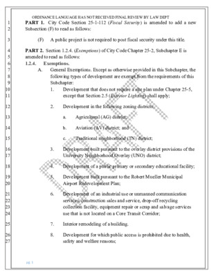
1 2 3 4 5 6 7 8 9 10 11 12 13 14 15 16 17 18 19 20 21 22 23 24 25 26 27 ORDINANCE LANGUAGE HAS NOT RECEIVED FINAL REVIEW BY LAW DEPT PART 1. City Code Section 25-1-112 (Fiscal Security) is amended to add a new Subsection (F) to read as follows: (F) A public project is not required to post fiscal security under this title. PART 2. Section 1.2.4. (Exemptions) of City Code Chapter 25-2, Subchapter E is amended to read as follows: 1.2.4. Exemptions. A. General Exemptions. Except as otherwise provided in this Subchapter, the following types of development are exempt from the requirements of this Subchapter: 1. Development that does not require a site plan under Chapter 25-5, except that Section 2.5 (Exterior Lighting) shall apply; 2. Development in the following zoning districts: Agricultural (AG) district; Aviation (AV) district; and a. b. c. Traditional neighborhood (TN) district; 3. Development built pursuant to the overlay district provisions of the University Neighborhood Overlay (UNO) district; 4. Development of a public primary or secondary educational facility; 5. Development built pursuant to the Robert Mueller Municipal Airport Redevelopment Plan; 6. Development of an industrial use or unmanned communication services, construction sales and service, drop-off recycling collection facility, equipment repair or scrap and salvage services use that is not located on a Core Transit Corridor; 7. Interior remodeling of a building. 8. Development for which public access is prohibited due to health, safety and welfare reasons; pg. 1 1 2 3 4 5 6 7 8 9 10 11 12 13 14 15 16 17 18 19 20 21 22 23 24 25 26 ORDINANCE LANGUAGE HAS NOT RECEIVED FINAL REVIEW BY LAW DEPT 9. Development of a warehouse if less than 25% of the gross floor area is used for a non-industrial use; 10. Sidewalk, shared use and urban trail projects managed by the City of Austin and processed under the City's General Permit program which are undertaken for the purpose of bringing existing facilities into compliance with the Americans With Disabilities Act; 11. A public mobility project in the right-of-way; and 12.[11.] Development built pursuant to any of the following adopted regulating plans: a. Transit-Oriented District Station Area Plan; b. North Burnet/Gateway (NBG) District; c. East Riverside Corridor; d. Waller Creek District; e. Downtown Austin Plan; or f. Airport Boulevard Corridor Plan. PART 3. City Code Section 25-8-42 (Administrative Variances) is amended to read as follows: § 25-8-42 ADMINISTRATIVE VARIANCES. (A) A variance under this section may not vary the requirements of Article 13 (Save Our Springs Initiative) and may not be granted for development of a property if any portion of the property abuts or is within 500 feet of the shoreline of Lake Austin, measured horizontally. (B) The director of the Watershed Protection Department may grant a variance from a requirement of: (1) Section 25-8-261 (Critical Water Quality Zone Development), only if: pg. 2 ORDINANCE LANGUAGE HAS NOT RECEIVED FINAL REVIEW BY LAW DEPT (a) (b) (c) (d) (a) (b) (c) necessary to protect public health and safety, or if it would provide a significant, demonstrable environmental benefit, as determined by a functional assessment of floodplain health as prescribed by the Environmental Criteria Manual, necessary to allow an athletic field in existence on October 28, 2013, to be maintained, improved, or replaced, necessary to allow an athletic field to be located in an area not otherwise allowed under Section 25-8-261(B)(5), or necessary to allow a hard surfaced trail to be located in an area not otherwise allowed under Section 25-8-261(B)(3); (2) Section 25-8-261 (Critical Water Quality Zone Development), for development within an urban watershed, only if the proposed development: is located not less than 25 feet from the centerline of a waterway, is located outside the erosion hazard zone, unless protective works are provided as prescribed in the Drainage Criteria Manual, does not increase non-compliance, if any, with Article 7, Division 1 (Critical Water Quality Zone Restrictions), Section 25-8-281 (Critical Environmental Features) or Section 25-8-282 (Wetland Protection), and (d) restores native vegetation and soils if development is removed from the Critical Water Quality Zone; (3) Subsection 25-8-262(B) (Critical Water Quality Zone Street Crossings), only outside the Barton Springs Zone; (4) Section 25-8-281 (Critical Environmental Features); (5) Section 25-8-322 (Clearing for a Roadway); 1 2 3 4 5 6 7 8 9 10 11 12 13 14 15 16 17 18 19 20 21 22 23 24 25 26 27 28 pg. 3 1 2 3 4 5 6 7 8 9 10 11 12 13 14 15 16 17 18 19 20 21 22 23 24 25 26 27 28 29 30 ORDINANCE LANGUAGE HAS NOT RECEIVED FINAL REVIEW BY LAW DEPT (6) Section 25-8-341 (Cut Requirements) or Section 25-8-342 (Fill Requirements), for a cut or fill of not more than eight feet in the desired development zone and, for a public primary or secondary educational facility, within the desired development zone or the drinking water protection zone; (7) Subsection 25-8-343(A) (Spoil Disposal); (8) Section 25-8-365 (Interbasin Diversion); (9) Subsection 25-8-392(B)(6) (Uplands Zone), Subsection 25-8- 392(C)(6) (Uplands Zone), Subsection 25-8-423(D) (Uplands Zone), or Subsection 25-8-453(E) (Uplands Zone). (C) It is the applicant's burden to establish that the findings described in this Section have been met. (D) The director of the Watershed Protection Department may grant a variance described in Subsection (B) only after determining that development in accordance with the variance meets the objective of the requirement for which the variance is requested and: (1) (2) (3) (4) for property in the Barton Springs Zone, the variance will result in water quality that is at least equal to the water quality achievable without the variance; for a variance from Section 25-8-261(B)(5), that the proposed work on or placement of the athletic field will have no adverse environmental impacts; for a variance from Section 25-8-281, that the proposed measures preserve all characteristics of the critical environmental feature; for a variance from Section 25-8-341 or Section 25-8-342 the cut or fill is not located on a slope with a gradient of more than 15 percent or within 100 feet of a classified waterway; (5) for a variance from Section 25-8-343(A), use of the spoil provides a necessary public benefit. Necessary public benefits include: pg. 4 (a) roadways; 1 2 3 4 5 6 7 8 9 10 11 12 13 14 15 16 17 18 19 20 21 22 23 24 25 26 27 28 ORDINANCE LANGUAGE HAS NOT RECEIVED FINAL REVIEW BY LAW DEPT (b) stormwater detention facilities; (c) public or private park sites; and (d) building sites that comply with Section 25-8-341 (Cut Requirements), Section 25-8-342 (Fill Requirements), and Chapter 25-7 (Drainage); and (6) (7) for a variance from Section 25-8-365, there are no adverse environmental or drainage impacts; for a variance from Subsection 25-8-392(B)(6), Subsection 25-8- 392(C)(6), Subsection 25-8-423(D), or Subsection 25-8-453(E), the variance: (a) is located outside the Barton Springs Zone; (b) (c) is the minimum deviation needed to provide necessary improvements to a public mobility project; and does not create a significant probability of adverse environmental impacts. (E) The Watershed Protection Department director shall prepare written findings to support the grant or denial of a variance request under this section. PART 4. City Code Section 25-8-211 (Water Quality Control Requirement) is amended to read as follows: § 25-8-211 WATER QUALITY CONTROL REQUIREMENT. (A) (B) In the Barton Springs Zone, water quality controls are required for all development. In a watershed other than a Barton Springs Zone watershed, water quality controls are required for development: (1) located in the water quality transition zone; (2) of a golf course, play field, or similar recreational use, if fertilizer, herbicide, or pesticide is applied; or pg. 5 1 2 3 4 5 6 7 8 9 10 11 12 13 14 15 16 17 18 19 20 21 22 23 24 25 26 27 28 29 30 ORDINANCE LANGUAGE HAS NOT RECEIVED FINAL REVIEW BY LAW DEPT (3) if the total of new and redeveloped impervious cover exceeds 8,000 square feet. (C) All new development must provide for removal of floating debris from stormwater runoff. (D) The water quality control requirements in this division do not require water quality controls on a single-family or duplex lot but apply to the residential subdivision as a whole. (E) The water quality control requirements in this division do not require water quality controls for a roadway improvement with less than 8,000 square feet of new impervious cover. For the purposes of this Section, roadway improvements are limited to intersection upgrades, low-water crossing upgrades, additions for curb-separated bicycle lanes, and additions for mass transit stops. (F) For public roadway projects, the calculation of new impervious cover for compliance with Subsection (B)(3) or Subsection (E) in any watershed shall: (1) be determined on a watershed basis rather than for the total project area; and (2) deduct existing impervious cover that is removed by the same project if the area with removed impervious cover is: (i) decompacted and revegetated as prescribed in the Environmental Criteria Manual and the Standard Specifications Manual; and (ii) located within the same watershed. PART 5. City Code Section 25-8-214 (Optional Payment Instead of Structural Controls in Urban Watersheds) is amended to read as follows: § 25-8-214 OPTIONAL PAYMENT INSTEAD OF STRUCTURAL CONTROLS [IN URBAN WATERSHEDS]. (A) The director of the Watershed Protection Department shall identify and prioritize water quality control facilities for the urban, suburban, water pg. 6 1 2 3 4 5 6 7 8 9 10 11 12 13 14 15 16 17 18 19 20 21 22 23 24 25 26 27 28 29 30 ORDINANCE LANGUAGE HAS NOT RECEIVED FINAL REVIEW BY LAW DEPT supply suburban, and water supply rural watersheds in a [an Urban] Watersheds Structural Control Plan. The Environmental Board shall review the plan in January of each year. (B) An Urban Watersheds Structural Control Fund is established for use in the design and construction of water quality control facilities in the urban watershed. (C) Instead of providing the water quality controls required under Section 25- 8-211 (Water Quality Control Requirement), in an urban watershed a developer may request approval to deposit with the City a nonrefundable cash payment, based on a formula established by the council. The director shall review the request and accept or deny the request based on the standards in the Environmental Criteria Manual. (D) The director shall deposit a payment made under Subsection (C) [this section] in the Urban Watersheds Structural Control Fund. (E) A Public Mobility Projects Structural Control Fund is established for use in the design and construction of water quality control facilities. (F) For a public mobility project in the right-of-way that is located in an urban, suburban, water supply suburban, or water supply rural watershed, an applicant may request approval to deposit a nonrefundable cash payment with the City instead of providing the water quality controls required under Section 25-8-211 (Water Quality Control Requirement). The payment shall be based on a formula established by the council. The director shall review the request and accept or deny the request based on the standards in the Environmental Criteria Manual. (G) The director shall deposit a payment made under Subsection (F) in the Public Mobility Projects Structural Control Fund. PART 6. City Code Section 25-8-262 (Critical Water Quality Zone Street Crossings) is amended to read as follows: § 25-8-262 CRITICAL WATER QUALITY ZONE STREET AND MOBILITY CROSSINGS. pg. 7 1 2 3 4 5 6 7 8 9 10 11 12 13 14 15 16 17 18 19 20 21 22 23 24 25 26 27 28 29 30 31 ORDINANCE LANGUAGE HAS NOT RECEIVED FINAL REVIEW BY LAW DEPT (A) In an urban watershed, an arterial street, collector street, [or] residential street, rail line, or public mobility project may cross a critical water quality zone of any waterway. (B) This subsection applies in a watershed other than an urban watershed. (1) A major waterway critical water quality zone may be crossed by an arterial street, rail line, or public mobility project identified in the Transportation Plan. (2) An intermediate waterway critical water quality zone may be crossed by an arterial street, [or] collector street, rail line, or public mobility project, except: a collector street crossing must be at least 2,500 feet from a collector or arterial street crossing on the same waterway; or in a water supply suburban or water supply rural watershed, or the Barton Springs Zone, a collector street crossing must be at least one mile from a collector or arterial street crossing on the same waterway. (3) A minor waterway critical water quality zone may be crossed by an arterial street, [or] collector street, or rail line, except: a collector street crossing must be at least 900 feet from a collector or arterial street crossing on the same waterway; or in a water supply suburban or water supply rural watershed, or the Barton Springs Zone, a collector street crossing must be at least 2,000 feet from a collector or arterial street crossing on the same waterway. (a) (b) (a) (b) (4) A minor waterway critical water quality zone may be crossed by a residential or commercial street if necessary to provide access to property that cannot otherwise be safely accessed. (C) In all watersheds, multi-use trails may cross a critical water quality zone of any waterway. (D) Notwithstanding subsections (A) and (B) and except in the Barton Springs Zone, a street or driveway may cross the critical water quality zone if the pg. 8 1 2 3 4 5 6 7 8 9 10 11 12 13 14 15 16 17 18 19 20 21 22 23 24 25 26 27 28 29 ORDINANCE LANGUAGE HAS NOT RECEIVED FINAL REVIEW BY LAW DEPT street or driveway is located in a center or corridor as identified on the growth concept map of the Imagine Austin Comprehensive Plan, as adopted by Ordinance No. 20120614-058, and if the proposed crossing: (1) is necessary to facilitate the development or redevelopment of a designated corridor or center as recommended in the Imagine Austin Comprehensive Plan, Chapter 4 (Shaping Austin: Building the Complete Community), growth concept map and related definitions; and (2) maintains the quality and quantity of recharge if located in a center or corridor designated as a sensitive environmental area in the Edwards Aquifer recharge zone, Edwards Aquifer contributing zone, or the South Edwards Aquifer recharge zone, as determined by the director of the Watershed Protection Department. PART 7. City Code Section 25-8-341 (Cut Requirements) is amended to read as follows: § 25-8-341 CUT REQUIREMENTS. (A) Cuts on a tract of land may not exceed four feet of depth, except: (1) in an urban watershed; (2) in a roadway or rail line right-of-way; (3) for construction of a building foundation or swimming pool; (4) for construction of a water quality control or detention facility and appurtenances for conveyance such as swales, drainage ditches, and diversion berms, if: (a) (b) (c) the design and location of the facility within the site minimize the amount of cut over four feet; the cut is the minimum necessary for the appropriate functioning of the facility; and the cut is not located on a slope with a gradient of more than 15 percent or within 100 feet of a classified waterway; pg. 9 1 2 3 4 5 6 7 8 9 10 11 12 13 14 15 16 17 18 19 20 21 22 23 24 25 ORDINANCE LANGUAGE HAS NOT RECEIVED FINAL REVIEW BY LAW DEPT for utility construction or a wastewater drain field, if the area is restored to natural grade; (5) (6) in a state-permitted sanitary landfill or a sand or gravel excavation located in the extraterritorial jurisdiction, if: (a) the cut is not in a critical water quality zone; (b) the cut does not alter a 100-year floodplain; (c) the landfill or excavation has an erosion and restoration plan approved by the City; and (d) all other applicable City Code provisions are met. (7) for any cut associated with construction of a multi-use trail, if: (a) the cut is not located on a slope with a gradient of more than 15 percent or within 100 feet of a classified waterway; (b) the cut is limited to no more than eight feet in depth; (c) (d) the cut is located in a public right-of-way or public easement; and the trail is designed in accordance with the Environmental Criteria Manual. PART 8. City Code Section 25-8-342 (Fill Requirements) is amended to read as follows: § 25-8-342 FILL REQUIREMENTS. (A) Fill on a tract of land may not exceed four feet of depth, except: (1) in an urban watershed; (2) in a roadway or rail line right-of-way; (3) under a foundation with sides perpendicular to the ground, or with pier and beam construction; pg. 10 1 2 3 4 5 6 7 8 9 10 11 12 13 14 15 16 17 18 19 20 21 22 23 24 25 26 27 ORDINANCE LANGUAGE HAS NOT RECEIVED FINAL REVIEW BY LAW DEPT (4) for construction of a water quality control or detention facility and appurtenances for conveyance such as swales, drainage ditches, and diversion berms, if: (a) (b) (c) (b) (c) (c) (d) the design and location of the facility within the site minimize the amount of fill over four feet; the fill is the minimum necessary for the appropriate functioning of the facility; and the fill is not located on a slope with a gradient of more than 15 percent or within 100 feet of a classified waterway; (5) for utility construction or a wastewater drain field; (6) in a state-permitted sanitary landfill located in the extraterritorial jurisdiction, if: (a) the fill is derived from the landfill operation; the fill is not placed in a critical water quality zone or a 100- year floodplain; the landfill operation has an erosion and restoration plan approved by the City; and (d) all other applicable City Code provisions are met; or (7) for fill associated with construction of a multi-use trail, if: (a) the fill is not located on a slope with a gradient of more than 15 percent or within 100 feet of a classified waterway; (b) the fill is limited to no more than eight feet in depth; the fill is located in a public right-of-way or public easement; and the trail is designed in accordance with the Environmental Criteria Manual. (B) A fill area must be restored and stabilized. pg. 11 1 2 3 4 5 6 7 8 9 10 11 12 13 14 15 16 17 18 19 20 21 22 23 24 25 26 27 ORDINANCE LANGUAGE HAS NOT RECEIVED FINAL REVIEW BY LAW DEPT (C) Fill for a roadway must be contained within the roadway clearing width described in Section 25-8-322 (Clearing For A Roadway). PART 9. City Code Section 25-8-372 (Uplands Zone) in Article 8 (Urban Watershed Requirements) is amended to read as follows: § 25-8-372 UPLANDS ZONE. (A) This section applies to development in an uplands zone. Impervious cover limits in this section are expressed as percentages of gross site area. (B) Maximum impervious cover for development within the City's zoning jurisdiction is established in Section 25-2-492 (Site Development Regulations). (C) Maximum impervious cover for development outside the City's zoning jurisdiction is 80 percent. way is 100 percent. (D) Maximum impervious cover for a public mobility project in the right-of- PART 10. City Code Section 25-8-392 (Uplands Zone) in Article 9 (Suburban Watershed Requirements) is amended to read as follows: § 25-8-392 UPLANDS ZONE. (A) This section applies to development in an uplands zone. Impervious cover limits in this section are expressed as percentages of gross site area. (B) This subsection applies in the extraterritorial jurisdiction and in the portions of the Lake, Rattan, Buttercup, South Brushy, and Brushy Creek watersheds that are in the zoning jurisdiction. (1) Impervious cover for a single-family residential use with a minimum lot size of 5,750 square feet may not exceed: (a) 45 percent; or (b) if development intensity is transferred under Section 25-8- 393 (Transfer Of Development Intensity), 50 percent. pg. 12 1 2 3 4 5 6 7 8 9 10 11 12 13 14 15 16 17 18 19 20 21 22 23 24 25 26 27 ORDINANCE LANGUAGE HAS NOT RECEIVED FINAL REVIEW BY LAW DEPT (2) Impervious cover for a duplex or single-family residential use with a lot smaller than 5,750 square feet in size may not exceed: (a) 55 percent; or (b) if development intensity is transferred under Section 25-8- 393 (Transfer Of Development Intensity), 60 percent. (3) Impervious cover for a multifamily residential use may not exceed: (a) 60 percent; or (b) if development intensity is transferred under Section 25-8- 393 (Transfer Of Development Intensity), 65 percent. (4) Impervious cover for a commercial use may not exceed: (a) 65 percent; or (b) if development intensity is transferred under Section 25-8- 393 (Transfer Of Development Intensity), 70 percent. (5) Impervious cover for mixed use may not exceed: (a) (b) (c) the limits in subsection (B)(3) for the portion of the ground floor that is multifamily residential; the limits in subsection (B)(4) for the portion of the ground floor that is commercial; and impervious cover for the entire site shall be based on the ratios determined on the ground floor. (6) Impervious cover for a public mobility project in the right-of-way may not exceed 90 percent. (C) This subsection applies in the portion of the zoning jurisdiction that is outside the Lake, Rattan, Buttercup, South Brushy, and Brushy Creek watersheds. (1) Impervious cover for a single-family residential use with a minimum lot size of 5,750 square feet may not exceed: pg. 13 ORDINANCE LANGUAGE HAS NOT RECEIVED FINAL REVIEW BY LAW DEPT (a) 50 percent; or (b) if development intensity is transferred under Section 25-8- 393 (Transfer Of Development Intensity), 60 percent. (2) Impervious cover for a duplex or single-family residential use with a lot smaller than 5,750 square feet in size may not exceed: (a) 55 percent; or (b) if development intensity is transferred under Section 25-8- 393 (Transfer Of Development Intensity), 60 percent. (3) Impervious cover for a multifamily residential use may not exceed: (a) 60 percent; or (b) if development intensity is transferred under Section 25-8- 393 (Transfer Of Development Intensity), 70 percent. (4) Impervious cover for a commercial use may not exceed: (a) 80 percent; or (b) if development intensity is transferred under Section 25-8- 393 (Transfer Of Development Intensity), 90 percent. (5) Impervious cover for mixed use may not exceed: (a) (b) (c) the limits in subsection (C)(3) for the portion of the ground floor that is multifamily residential: the limits in subsection (C)(4) for the portion of the ground floor that is commercial; and impervious cover for the entire site shall be based on the ratios determined on the ground floor. (6) Impervious cover for a public mobility project in the right-of-way may not exceed 90 percent. 1 2 3 4 5 6 7 8 9 10 11 12 13 14 15 16 17 18 19 20 21 22 23 24 25 pg. 14 1 2 3 4 5 6 7 8 9 10 11 12 13 14 15 16 17 18 19 20 21 22 23 24 25 26 27 28 29 ORDINANCE LANGUAGE HAS NOT RECEIVED FINAL REVIEW BY LAW DEPT PART 11. City Code Section 25-8-422 (Water Quality Transition Zone) in Article 10 (Water Supply Suburban Watershed Requirements) is amended to read as follows: § 25-8-422 WATER QUALITY TRANSITION ZONE. (A) Development is prohibited in a water quality transition zone that lies over the South Edwards Aquifer recharge zone, except for: (1) development described in Article 7, Division 1 (Critical Water Quality Zone Restrictions); and (2) minor drainage facilities or water quality controls that comply with Section 25-8-364 (Floodplain Modification) and the floodplain modification criteria in the Environmental Criteria Manual. (B) In a water quality transition zone that does not lie over the South Edwards Aquifer recharge zone, the impervious cover of the land area of a site may not exceed 18 percent. This limit on impervious cover does not apply to a street, rail line, or public mobility project allowed to cross a critical water quality zone under Section 25-8-262 (Critical Water Quality Zone Street Crossings). In determining land area, land in the 100 year floodplain is excluded. (C) Water quality controls may be located in a water quality transition zone that does not lie over the South Edwards Aquifer recharge zone. PART 12. City Code Section 25-8-423 (Uplands Zone) in Article 10 (Water Supply Suburban Watershed Requirements) is amended to read as follows: § 25-8-423 UPLANDS ZONE. (A) This section applies to development in an uplands zone. Impervious cover limits in this section are expressed as percentages of net site area. (B) Impervious cover for a duplex or single-family residential use may not exceed: (1) 30 percent; or (2) if development intensity is transferred under Section 25-8-424 (Transfer Of Development Intensity), 40 percent. pg. 15 1 2 3 4 5 6 7 8 9 10 11 12 13 14 15 16 17 18 19 20 21 22 23 24 25 26 27 ORDINANCE LANGUAGE HAS NOT RECEIVED FINAL REVIEW BY LAW DEPT (C) Impervious cover for a commercial, multifamily residential use, or mixed use may not exceed: (1) 40 percent; or (2) if development intensity is transferred under Section 25-8-424 (Transfer Of Development Intensity), 55 percent. (D) Impervious cover for a public mobility project in the right-of-way may not exceed 65 percent. PART 13. Subsection (B) of City Code Section 25-8-452 (Water Quality Transition Zone) in Article 11 (Water Supply Rural Watershed Requirements) is amended to read as follows: (B) Development is prohibited in a water quality transition zone that lies outside the South Edwards Aquifer recharge zone, except for: (1) development described in Article 7, Division 1 (Critical Water Quality Zone Restrictions); (2) streets, rail lines, or public mobility projects; (3) minor drainage facilities or water quality controls that comply with Section 25-8-364 (Floodplain Modification) and the floodplain modification guidelines of the Environmental Criteria Manual; and (4) duplex or single-family residential development with a minimum lot size of two acres and a density of not more than one unit for each three acres, excluding acreage in the 100 year flood plain. PART 14. City Code Section 25-8-453 (Uplands Zone) in Article 11 (Water Supply Rural Watershed Requirements) is amended to read as follows: § 25-8-453 UPLANDS ZONE. (A) This section applies to development in an uplands zone. Density and impervious cover limits are based on net site area. (B) For a duplex or single family residential use, density may not exceed: pg. 16 1 2 3 4 5 6 7 8 9 10 11 12 13 14 15 16 17 18 19 20 21 22 23 24 25 26 27 28 29 30 ORDINANCE LANGUAGE HAS NOT RECEIVED FINAL REVIEW BY LAW DEPT one unit for each two acres, with a minimum lot size of three-quarters acre; or if development intensity is transferred under Section 25-8-454 (Transfer of Development Intensity), one unit for each acre, with a minimum lot size of one-half acre. (1) (2) (C) This subsection applies to cluster housing. (1) Density may not exceed: (a) one unit for each acre; or (b) if development intensity is transferred under Section 25-8- 454 (Transfer of Development Intensity), two units for each acre. (2) At least 40 percent of the uplands area of a site must be retained in or restored to its natural state to serve as a buffer. The buffer must be contiguous to the development, and must receive overland drainage from the developed areas of the site unless a water quality control is provided. Use of the buffer is limited to fences, water quality controls that comply with Subdivision 25-8-213(C)(3) (Water Quality Control Standards), utilities that cannot reasonably be located elsewhere, irrigation lines not associated with wastewater disposal, and access for site construction. A wastewater disposal area may not be located in the buffer. (D) This subsection applies to a commercial, multifamily residential use, or mixed use. (1) Impervious cover may not exceed: (a) 20 percent; or (b) if development intensity is transferred under Section 25-8- 454 (Transfer Of Development Intensity), 25 percent. (2) At least 40 percent of the uplands area of a site must be retained in or restored to its natural state to serve as a buffer. The buffer must be contiguous to the development, and must receive overland drainage pg. 17 1 2 3 4 5 6 7 8 9 ORDINANCE LANGUAGE HAS NOT RECEIVED FINAL REVIEW BY LAW DEPT from the developed areas of the site unless a water quality control is provided. Use of the buffer is limited to fences, water quality controls that comply with Subdivision 25-8-213(C)(3) (Water Quality Control Standards), utilities that cannot reasonably be located elsewhere, irrigation lines not associated with wastewater disposal, and access for site construction. A wastewater disposal area may not be located in the buffer. (E) Impervious cover for a public mobility project in the right-of-way may not exceed 55 percent. pg. 18