Meeting of the Codes and Ordinances Joint Committee October 16, 2024, at 6:00 p.m. Permitting and Development Center (PDC) – Room #1406 6310 Wilhelmina Delco Drive Austin, TX 78752 Some members of the Codes and Ordinances Joint Committee may be participating in the video conference. Public comment will be allowed in-person or remotely by telephone. Speakers may only register to speak on an item once, either in-person or remotely, and will be allowed up to three minutes to provide their comments. Registration no later than noon the day before the meeting is required for remote participation. To register, call or email the board liaison, Paul Ray Books, at 512-974-3173, Paul.Books@austintexas.gov. CURRENT COMMITTEE MEMBERS Alejandra Flores (Chair) Claire Hempel (Vice-Chair) Greg Anderson Awais Azhar Betsy Greenberg Felicity Maxwell Lonny Stern CALL TO ORDER PUBLIC COMMUNICATION: GENERAL Speakers signed up prior to commencement of the meeting will be allowed to address their concerns regarding items not posted on the agenda. APPROVAL OF MINUTES 1. Approval of the September 18, 2024, meeting minutes. 1 DISCUSSION AND ACTION ITEMS 2. Hays Commons Site-Specific Save Our Springs (SOS) Amendment Initiation. Discussion and possible action to recommend initiation of site-specific amendments to City Code Chapter 25-8, Subchapter A, Article 13 of the Save Our Springs Initiative as necessary for the Hays Commons Municipal Utility District. City Staff: Sean Watson, Watershed Protection Department, Sean.Watson@austintexas.gov, 512- 963-2167. 3. C20-2024-024 Colorado River Protections. Discussion and possible action to recommend amendments to City Code Title 25 (Land Development) to increase water quality and erosion protections along the Colorado River below Longhorn Dam. City Staff: Liz Johnston, Watershed Protection Department, Liz.Johnston@austintexas.gov, 512-974-2619; Matt Hollon, Watershed Protection Department, Matt.Hollon@austintexas.gov, 512-974-2238. 4. C20-2024-002 North Burnet Gateway Regulating Plan Signage. Discussion and possible action to recommend amendments to City Code Title 25 (Land Development) to modify the Regulating Plan for the North Burnet/Gateway Zoning District (North Burnet/Gateway Regulating Plan) to add optional Sign standards. City Staff: Jorge Rousselin, Planning Department, Jorge.Rousselin@austintexas.gov, 512-974- 2975. 5. C20-2024-021 Safety Bollards. Discussion and possible action to recommend amendments to City Code Title 25 (Land Development) to require the installation of crash-rated bollards or other similar safety barriers to prevent vehicle-into-building crashes at the pedestrian entrances of medical facilities with nearby vehicular traffic. City Staff: Amber Hutchens, Transportation and Public Works Amber.Hutchens@austintexas.gov, 512-974-5646; Curtis Beaty, Transportation and Public Works, Curtis.Beaty@austintexas.gov, 512-974-6471. 6. 2025 Meeting Schedule. Discussion and possible action …
Meeting of the Codes and Ordinances Joint Committee September 18, 2024, at 6:00 p.m. Permitting and Development Center (PDC) – Room #2103 6310 Wilhelmina Delco Drive Austin, TX 78752 Some members of the Codes and Ordinances Joint Committee may be participating in the video conference. Public comment will be allowed in-person or remotely by telephone. Speakers may only register to speak on an item once, either in-person or remotely, and will be allowed up to three minutes to provide their comments. Registration no later than noon the day before the meeting is required for remote participation. at 512-974-7288 or email To Jordan.Feldman@austintexas.gov. Jordan Feldman, the board call or register, liaison, COMMITTEE MEMBERS PRESENT Alejandra Flores (Chair) Claire Hempel (Vice-Chair) Greg Anderson Awais Azhar Betsy Greenberg Lonny Stern COMMITTEE MEMBER ABSENT Felicity Maxwell CALL TO ORDER Vice Chair Hempel called the meeting to order at 6:02 pm. PUBLIC COMMUNICATION: GENERAL Speakers signed up prior to commencement of the meeting will be allowed to address their concerns regarding items not posted on the agenda. No Public Communication. 1 DRAFT APPROVAL OF MINUTES 1. Approval of the June 18, 2024, meeting minutes. On a motion by Commissioner Azhar seconded by Chair Flores, the minutes from June 18, 2024, meeting were approved unanimously (6-0) with an amendment to fix the title of “Committee Members Absent.” Commissioner Maxwell was absent. DISCUSSION AND ACTION ITEMS 2. C20-2024-017 Planned Development Area 2 (PDA2) & Density Bonus for Commercial Highway & Industrial Zones. Discussion and possible action to recommend amendments to City Code Title 25 (Land Development) to create a Planned Development Area 2 Combining District and a Density Bonus for Commercial Highway and Industrial zones Combining District that includes granting additional heights and residential uses in exchange for providing income restricted units or a fee-in-lieu. City Staff: Alan Pani, Planning Department, (512) 974-8084, alan.pani@austintexas.gov. Alan Pani presented. Commissioner Azhar moved to forward the staff recommendation to the Planning Commission, seconded by Commissioner Anderson, with the added recommendations to ensure that other community benefits in the initiating resolution can be considered at the Planning Commission and to consider revising employee recreation as a conditional use. Commissioner Anderson moved to consider an amendment to eliminate the 10-foot setback after 90 feet seconded by Vice Chair Hempel. The amendment passed on a 5-1 vote, with Commissioner Greenberg voting against. The motion, as amended, passed on a 4-1-1 vote, with Commissioner …
NEW BUSINESS: CODE AMENDMENT INITIATION REVIEW SHEET Amendment: Consider initiation of amendments to Title 25 of the City Code related to the Barton Springs Zone. Description: Site specific amendment to SOS (Save our Springs) Ordinance as necessary for the development proposed in the Hays Commons MUD application C12M-2024-0003 including the development of 700 single-family residences, 12.1 acres of commercial use, parkland/open space and associated water, wasterwater, drainage and transportation infrastructure. Anticipated community benefits: • COA environmental protection for 497 acres of environmentally sensitive area (including 290 acres currently outside of the COA’s ETJ) • Superior parkland dedication including 225 acres of open space • Superior environment protections including bird safe design and light pollution • Enhanced pedestrian mobility including connectivity to Violet Crown Trai and 45S reduction criteria Traill Proposed Language: TBD (draft ordinance language will be brought to COJC and PC for a recommendation before going to Council for final approval). Background: The Hays Commons project is a proposed master planned community with a mix of single family residential, commercial, parks, and open space land uses. The property consists of approximately 497.85 acres generally located at FM 1626 and SH45. A 290-acre portion of the property is located outside the ETJ of the City and in unincorporated Hays County. The remaining 246 acres is in the ETJ of the City and within Hays and Travis County. The project is requesting the City’s consent to the creation of the Hays Commons Municipal Utility District. The purpose of the District is to finance improvements to prepare the site as it transitions from undeveloped land into a single-family development with a commercial area. The District will issue bonds to pay for infrastructure for water and wastewater service, drainage, water quality/floodplain mitigation, erosion control, roads, and parks. Approximately 46% of the project area will be preserved for conservation land, open space, and parks. Approximately 160 acres of conservation land will encompass the Little Bear Creek and provide environmental protection and ecological functions. Additional parks and open space will run along SH 45 and connect the neighborhood to the 45S Trail and the Violet Crown Trail regional trail networks. allow impervious cover for the project to exceed 15% NSA up to 25% NSA. Staff Recommendation: To be determined by WPD staff after initiation of the code amendment. The applicant is seeking a site-specific amendment to the SOS Ordinance to 1 Board and Commission Actions: …
SOS Site-Specific Code Amendment Initiation for Hays Commons MUD 2833 ½ Bliss Spillar Road Sean Watson Environmental Program Coordinator Watershed Protection C I T Y O F A U S T I N W A T E R S H E D P R O T E C T I O N D E P A R T M E N T HAYS Commons Municipal Utility District (MUD) Not und er cons id era tion a t this time – This item will return a t sa me time a s the p rop os ed SOS a mend ment • • F ina nces p ublic infra s tructure im p rovements a s d efined by Sta te La w a nd Texa s Wa ter Cod e with the consent of the City. The consent a g reement p rov id es cer ta inty reg a rd ing the reg ula tor y req uirements a p p lica ble to the Dis trict a nd p rovid es the City with a ssura nce of a s up erior q ua lity of d evelop ment. C I T Y O F A U S T I N W A T E R S H E D P R O T E C T I O N D E P A R T M E N T Hays Commons C 1 2 M - 2 0 2 4 - 0 0 0 3 C I T Y O F A U S T I N W A T E R S H E D P R O T E C T I O N D E P A R T M E N T Proposed Development Hays Commons Description Land Use Financial Total Acreage Projected Population Single Family Multi-Family Commercial Open Space Proposed Total Bonds (Roads) Assessed valuation Proposed MUD Tax Rate Proposed Total Bonds (Water, Wastewater, Drainage) $47 million C I T Y O F A U S T I N W A T E R S H E D P R O T E C T I O N D E P A R T M E N T 4 497 2,450 700 Units 0 Units 12.1 acres 225.35 acres $13.22 million $495,740,000 $1.00/$100 Proposed Development C I T Y O F A U S T I N W A T E R …
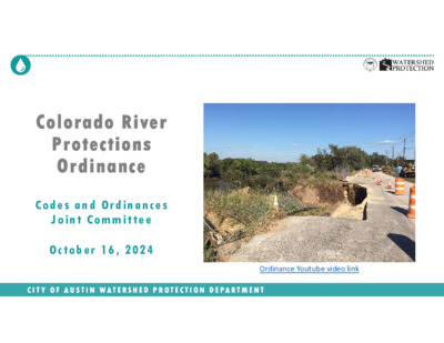
Colorado River Protections Ordinance C o d e s a n d Or d i na n c es J o i nt C o m m i tte e Oct o b er 1 6 , 2 02 4 C I T Y O F A U S T I N W A T E R S H E D P R O T E C T I O N D E P A R T M E N T Ordinance Youtube video link Presentation Outline Background • Council Resolution and Goals • Colorado River Overview • Erosion & Water Quality Threats and Costs to Community Draft Ordinance • Draft Proposal & Analysis • Schedule Discussion C I T Y O F A U S T I N W A T E R S H E D P R O T E C T I O N D E P A R T M E N T 2 Presentation Outline Background • Council Resolution and Goals • Colorado River Overview • Erosion & Water Quality Threats and Costs to Community Draft Ordinance • Draft Proposal & Analysis • Schedule Discussion C I T Y O F A U S T I N W A T E R S H E D P R O T E C T I O N D E P A R T M E N T 3 Council Resolution Community members asked Council to strengthen Colorado River protections; Council thereafter included in their June 2022 Council resolution: “… evaluate the effectiveness of existing Critical Water Quality Zone and Erosion Hazard Zone buffers on the Colorado River downstream of the Longhorn Dam and to propose protections that will provide adequate protections to the river that will ensure a healthy riparian corridor to stabilize the riverbank and protect property from erosion” C I T Y O F A U S T I N W A T E R S H E D P R O T E C T I O N D E P A R T M E N T 4 Longhorn Dam Austin’s Full Purpose (City) Limits CWQZ Buffer Acres 400ft Buffer Acres Acres Parcel Count 241 243 484 50% 50% 100% 1,054 14,896 15,950 7% 93% 100% 281 1,929 2,211 13% 87% 100% 391 2,184 2,575 15% 85% 100% Acres 400ft minus CWQZ 109 255 364 …
10/11/24 C20-2022-0025 ORDINANCE AMENDMENT REVIEW SHEET Amendment: C20-2022-0025, Land Development Code Amendment to Title 25-7 Drainage Description: Consider an ordinance regarding amendments to Title 25 related to adequate protections to the Colorado River downstream of the Longhorn Dam. Proposed Language: To revise 25-7-32(B)(2) to establish the erosion hazard zone of the Colorado River downstream of the Longhorn Dam as 200 feet from the ordinary high water mark, with exceptions for trails. See Attachment A. Summary of proposed code changes: The proposed code change would expand the Erosion Hazard Zone associated with the Colorado River downstream of the Longhorn Dam to 200 feet from the ordinary high-water mark (federally defined river bank). The existing Erosion Hazard Zone is measured 100 feet from the ordinary high-water mark. Staff are proposing exceptions to this requirement for hard-surfaced trails. Background: This ordinance responds to Council Resolution No. 20220609-061, which initiated Land Development Code amendments related to environmental, drainage, and landscape requirements. A previous ordinance addressed many of the elements of this resolution, but certain proposed changes were not adopted at the time so that staff could conduct additional analyses and community outreach. The proposed ordinance addresses direction to staff to “evaluate the effectiveness of the existing Critical Water Quality Zone and Erosion Hazard Zone buffers on the Colorado River downstream of the Longhorn dam and to propose protections that will provide adequate protections to the river that will ensure a healthy riparian corridor to stabilize the riverbank and protect property from erosion.” Board and Commission Actions: October 16, 2024: Codes and Ordinances Joint Committee action is pending. November 6, 2024: Environmental Commission action is pending. November 12, 2024: Planning Commission action is pending. Council Action: June 9, 2022: City Council approved Resolution No. 20220609-061, initiating amendments to Title 25 related to environmental, drainage, and landscape requirements. December 12, 2024: City Council action is pending. Ordinance Number: N/A City Staff: Matt Hollon, Regulatory Policy Analyst, Liz Johnston, Interim Environmental Officer, Watershed Protection Department Phone: (512) 974-2238 Email: matt.hollon@austintexas.gov 1 10/11/24 C20-2022-0025 Attachment A: Proposed Code Language § 25-7-32 EROSION HAZARD ZONE ANALYSIS REQUIREMENT. For a preliminary plan or plat application to demonstrate that the development proposed in a preliminary plan or plat application does not create negative erosion impacts, the owner of real property may provide, at the owner's expense, an erosion hazard zone analysis. For all other development applications, the director may require the …
North Burnet/Gateway Regulating Plan Amendment Recommendations on Optional Sign Regulations in Response to Council Resolution No. 20230504-020 C20-2024-002 Recent amendments to the NBG Regulating Plan Council-initiated amendments to Commercial Mixed-Use (CMU) Gateway Subdistrict: • • Increase maximum building height up to 420 feet when using a development bonus. Increase maximum floor-to-area (FAR) ratio up to 12:1 when using a development bonus. • Approved by Ordinance No. 20221027-044 Planning Commission-initiated amendments to Transit-Oriented District (TOD) Gateway and TOD- Midway subdistricts : • • Increase maximum building height up to 491 feet when using a development bonus. Increase maximum floor-to-area (FAR) ratio up to 12:1 when using a development bonus. • Approved by Ordinance No. 20230209-046. Recent amendments to the NBG Regulating Plan Apply a wider variety of subdistricts to parcels in the North Burnet/Gateway Regulating Plan west of Mopac Creation of Commercial Mixed- Use (CMU-M) Midway Subdistrict: Creation of Research and Sciences Mixed-use (RSMU) Subdistrict: • • Increase maximum building height up to 350 feet when using a development bonus. Increase maximum floor-to-area (FAR) ratio up to 10:1 when using a development bonus. • Approved by Ordinance No. 20231019-056 • Creation of research-specific land uses • Continuation of university-related land uses • Increase maximum building height up to 491 feet when using a development bonus. Increase maximum floor-to-area (FAR) ratio up to 12:1 when using a development bonus. • • Approved by Ordinance No. 20240321-047 What does Council Resolution 20230504-020 ask for? The City Manager is directed to process amendments necessary to accomplish the purposes set forth in this resolution and return with a draft ordinance for City Council consideration by October 19, 2023: In progress 1. Keep the base entitlements the same and increase the allowable maximum height and FAR in all subdistricts through a development bonus; 2. Apply a wider variety of subdistricts to parcels in the North Burnet/Gateway Regulating Plan west of Mopac; Optional Standards In progress 3. Amend sign regulations in the North Burnet/Gateway Regulating Plan to align with City Code Chapter 25-10 (Sign Regulations), including common area signage, directional signage, free standing and wall signage on buildings, wayfinding signage, park signage, and Capital Metro signage, and any other signage regulations; 4. Adjust the Land Use Standards for General Retail Sales (Figure 2-1) to remove square footage limitations in cases where a single project or property owner may provide retail space to multiple small businesses that will …
Working Dra� 10/03/2024 4.8 SIGN REGULATIONS 4.8.1 Applicability Standard Sec�on 4.8.2 Sign Regula�ons Sec�on 4.8.3 Op�onal Sign Regula�ons Applies if the NBG Subdistrict is: Applies if the Adjacent Street is: TOD CMU NMU NR WMU CI CTC PPC UR HWY • • • • • • • • -- • -- • • • • • • • -- • Applies to the Following All development All development All development in the NBG Planning Area may request to "opt-in" to the Sign Regula�ons in Sec�on 4.8.3 upon submital of a Site Development Permit applica�on. If no opt-in request is received as part of the submital of a Site Development Permit applica�on, the Sign Regula�ons in Sec�on 4.8.2 apply. 4.8.2 Sign Regula�ons this sec�on: A. All development in the NBG Planning Area shall comply with the Sign Regula�ons in i. A sign may not exceed 150 square feet of sign area, except that this limita�on does not apply along the following roadways within the sta�on area: (1) Burnet Road; (2) Metric Boulevard; (3) Braker Lane; (4) Capital of Texas Hwy; (5) Stonelake Boulevard; (6) Research Boulevard (183); and (7) MoPac. ii. A freestanding sign is prohibited. iii. A roof sign is prohibited. images. v. all signs are permited iv. Signs above the 2nd floor are allowed to be lighted but not with moving parts or B. A wall sign may be a projec�ng sign if the sign complies with this subsec�on. i. One projec�ng sign for each building facade is permited. ii. The sign area of a projec�ng sign may not exceed 35 square feet. iii. A sign may extend from the building facade not more than the lesser of: 1. Six feet; or a distance equal to two-thirds the width of the abu�ng sidewalk. iv. For a sign that projects over state right-of-way, the state must approve the sign. C. For all development located on a NBG Core Transit Corridor, one freestanding monument sign is permited on a lot. The height of this sign shall not exceed 6 feet and the sign area may not exceed 100 square feet. 1 Working Dra� 10/03/2024 4.8.3 Op�onal Sign Regula�ons A. Defini�ons: 1. FAÇADE-MOUNTED WALL SIGN means a sign atached to the exterior of a building and intended to iden�fy major business en��es at a distance and orient motorists and pedestrians to the business en�ty’s loca�on within a building. 2. FREESTANDING WALL SIGN …
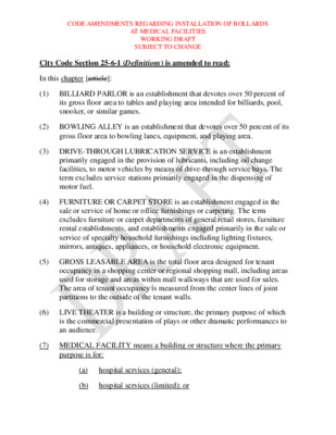
CODE AMENDMENTS REGARDING INSTALLATION OF BOLLARDS AT MEDICAL FACILITIES WORKING DRAFT SUBJECT TO CHANGE City Code Section 25-6-1 (Definitions) is amended to read: In this chapter [article]: (1) BILLIARD PARLOR is an establishment that devotes over 50 percent of its gross floor area to tables and playing area intended for billiards, pool, snooker, or similar games. (2) BOWLING ALLEY is an establishment that devotes over 50 percent of its gross floor area to bowling lanes, equipment, and playing area. (3) DRIVE-THROUGH LUBRICATION SERVICE is an establishment primarily engaged in the provision of lubricants, including oil change facilities, to motor vehicles by means of drive-through service bays. The term excludes service stations primarily engaged in the dispensing of motor fuel. (4) FURNITURE OR CARPET STORE is an establishment engaged in the sale or service of home or office furnishings or carpeting. The term excludes furniture or carpet departments of general retail stores, furniture rental establishments, and establishments engaged primarily in the sale or service of specialty household furnishings including lighting fixtures, mirrors, antiques, appliances, or household electronic equipment. (5) GROSS LEASABLE AREA is the total floor area designed for tenant occupancy in a shopping center or regional shopping mall, including areas used for storage and areas within mall walkways that are used for sales. The area of tenant occupancy is measured from the center lines of joint partitions to the outside of the tenant walls. (6) LIVE THEATER is a building or structure, the primary purpose of which is the commercial presentation of plays or other dramatic performances to an audience. (7) MEDICAL FACILITY means a building or structure where the primary purpose is for: (a) hospital services (general); (b) hospital services (limited); or CODE AMENDMENTS REGARDING INSTALLATION OF BOLLARDS AT MEDICAL FACILITIES WORKING DRAFT SUBJECT TO CHANGE (c) medical offices, if the building or structure is a walk-in clinic being used for the consultation, diagnosis, therapeutic, preventative, or medical care for minor illnesses and injuries. (8[7]) MOTION PICTURE THEATER is a building or structure, the primary purpose of which is the commercial presentation of motion pictures to an audience. (9) PEDESTRAIN ENTRANCE means a functional entrance or door that is publicly accessible and designed for pedestrian use. (10[8]) REGIONAL SHOPPING MALL means a single building containing over 600,000 square feet of gross leasable area and enclosing two or more stores with main entrances from a covered common pedestrian area. Typical …
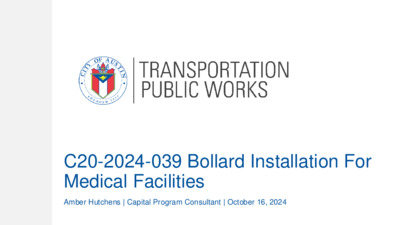
C20-2024-039 Bollard Installation For Medical Facilities Amber Hutchens | Capital Program Consultant | October 16, 2024 Presentation Overview • Background • Council Resolution • Code Amendment • Criteria/Rule • Schedule • Questions/Answers 10/9/2024 2 City Council Resolution 20240718-092 BE IT RESOLVED BY THE CITY COUNCIL OF THE CITY OF AUSTIN: City Council initiates amendments to City Code, including Title 25 (Land Development), to require the installation of crash-rated bollards or other similar safety barriers to prevent vehicle-into-building crashes at the pedestrian entrances of medical facilities with nearby vehicular traffic. City Council Resolution 20240718-092 “BE IT FURTHER RESOLVED: When proposing amendments initiated by this Resolution, the City Manager is directed to explore: 1. the feasibility of requiring safety barriers in public right-of-way areas adjacent to medical facilities to enhance pedestrian safety and prevent vehicle crashes; 2. whether permit applications to expand, remodel, or upgrade existing facilities can trigger this requirement to install safety bollards; incentives for existing facilities to voluntarily comply with new City requirements to install bollards; 3. 4. 5. recommendations for the City's state and federal legislative agenda; and any other necessary changes that achieve the objectives of this resolution. BE IT FURTHER RESOLVED: The City Manager is directed to engage with stakeholders, including medical facility operators, with the goal of bringing about compliance with any new requirements City Council adopts.” Changes to Title 25 LDC Chapter 25-6, Transportation Modify LDC 25-6-1 (Definitions) (7) MEDICAL FACILITY means a building or structure where the primary purpose is for: (a) hospital services (general); (b) hospital services (limited); or (c) medical offices, if the building or structure is a walk-in clinic being used for the consultation, diagnosis, therapeutic, preventative, or medical care for minor illnesses and injuries. (9) PEDESTRIAN ENTRANCE means a functional entrance or door that is publicly accessible and designed for pedestrian use. Changes to Title 25 Create a new Section in 25-6 (Transportation) 25-6-324 PEDESTRIAN SAFETY BARRIERS FOR MEDICAL FACILITIES (A) This section applies to a development application for new construction of a medical facility. (B) An applicant is required to install security bollards in front of each pedestrian entrance to a medical facility in accordance with the Transportation Criteria Manual. (C) The installation of security bollards cannot obstruct accessible routes or accessible means of ingress and egress to the pedestrian entrance. (D) The director may waive this requirement if the applicant demonstrates the walkway to the pedestrian entrance …
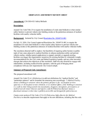
Case Number: C20-2024-021 ORDINANCE AMENDMENT REVIEW SHEET Amendment: C20-2024-021 Safety Bollards Description: Amend City Code Title 25 to require the installation of crash-rated bollards or other similar safety barriers to prevent vehicle-into-building crashes at the pedestrian entrances of medical facilities with nearby vehicular traffic. Background: Initiated by City Council Resolution No. 20240718-092. On July 18, 2024, City Council approved Resolution No. 20240718-092, to require the installation of crash-rated bollards or other similar safety barriers to prevent vehicle-into- building crashes at the pedestrian entrances of medical facilities with nearby vehicular traffic. The resolution directed staff to explore: the feasibility of requiring safety barriers in public right-of-way areas adjacent to medical facilities to enhance pedestrian safety and prevent vehicle crashes; whether permit applications to expand, remodel, or upgrade existing facilities can trigger this requirement; incentives for existing facilities to voluntarily comply; recommendations for the City's state and federal legislative agenda; and any other necessary changes that achieve the objectives of this resolution. Staff was also directed to engage with stakeholders, including medical facility operators, with the goal of bringing about compliance with any new requirements City Council adopts. Summary of Proposed Code Amendment: The proposed amendment will: Amend City Code 25-6-1 (Definitions) to add new definitions for “medical facility” and “pedestrian entrance” and to renumber the remaining uses accordingly: 7) Medical Facility means a building or structure where the primary purpose is for: (a) hospital services (general); or (b) hospital services (limited); or (c) medical offices, if the building or structure is a walk-in clinic being used for the consultation, diagnosis, therapeutic, preventative, or medical care for minor illnesses and injuries; and (9) Pedestrian Entrance means a functional entrance or door that is publicly accessible and designed for pedestrian use. Create a new section of City Code (25-6-324 Pedestrian Safety Barrier for Medical Facilities) to describe requirements that apply to the new definitions, including that the code: 1 Case Number: C20-2024-021 • Applies to all new construction of pedestrian entrances on construction that meets the definition of a medical facility. posted in a subsequent rule. • Refers applicants to technical guidance in Transportation Criteria Manual, to be • Allows for alternative compliance if designed in a manner that mitigates the risk of vehicular crashes into the pedestrian entrance. Proposed Text Amendment(s): See attached draft ordinance. Staff Recommendation: Recommended Staff recommend the proposed Pedestrian Safety Barrier for Medical Facilities language for inclusion in …
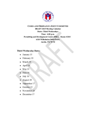
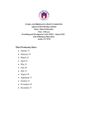
CODES AND ORDINANCES JOINT COMMITTEE DRAFT 2025 Meeting Calendar Dates: Third Wednesdays Time: 6:00 p.m. Permitting and Development Center (PDC) – Room #2103 6310 Wilhelmina Delco Drive Austin, TX 78752 Third Wednesday Dates: • January 15 • February 19 • March 19 • April 16 • May 21 • June 18 • July 16 • August 20 • September 17 • October 15 • November 19 • December 17
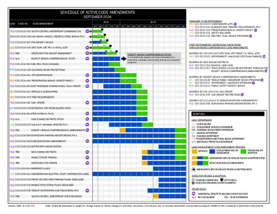
SCHEDULE OF ACTIVE CODE AMENDMENTS SEPTEMBER 2024 LEAD CASE NO. CODE AMENDMENT 2024 2025 AUG SEP OCT NOV DEC JAN FEB MAR APR MAY JUN JUL AUG SEP OCT NOV DEC DENSITY BONUS COMPREHENSIVE STUDY A comprehensive analysis with recommendations to streamline, calibrate, and combine existing and proposed programs. PLD C20-2022-003 SOUTH CENTRAL WATERFRONT COMBINING DIS. EDD C20-2023-026 LIVE MUSIC VENUE & CREATIVE SPACE BONUS PH 2 PLD C20-2024-017 PDA DENSITY BONUS DSD C20-2023-045 SITE PLAN LITE PH 2 & INFILL LOTS PLD TBD CRESTVIEW TOD HEIGHT AMENDMENT PLD N/A DENSITY BONUS COMPREHENSIVE STUDY PLD C20-2024-002 NBG REG. PLAN (SIGNAGE) WPD C20-2022-025 COLORADO RIVER PROTECTIONS DSD C20-2024-014 STR MODIFICATIONS DSD C20-2024-016 PRESERVATION BONUS UPDATE PHASE 1 PLD C20-2024-003 EAST RIVERSIDE CORRIDOR REG. PLAN UPDATE DSD C20-2024-013 ARTICLE 9 LANDSCAPING DSD C20-2024-015 TREE REQUIREMENTS PLD C20-2024-010 UNO UPDATE WPD C20-2022-025 DETENTION FOR REDEVELOPED SITES PLD C20-2024-004 ETOD OVERLAY (PH 2) PLD N/A NEW ZONING DISTRICTS STUDY HD C20-2023-037 S.M.A.R.T. HOUSING UPDATES PH 2 PLD TBD DENSITY BONUS COMPREHENSIVE AMENDMENTS PLD C20-2024-008 DOWNTOWN PARKING MODIFICATIONS PH 2 PLD C20-2024-018 DDB/DOWNTOWN AMENDMENTS PLD C20-2023-023 NOTIFICATION MODIFICATION PLD TBD NEW ZONING DISTRICTS PLD TBD HOME (FUTURE PHASES) PLD TBD CRESTVIEW TOD UPDATE PLD C20-2018-004 MIRRORED GLASS AE C20-2023-014 UNDERGROUND ELECTRIC UTILITY DISTRIBUTION LINES PLD C20-2023-031 FRONT OR SIDE YARD PARKING FILING DEADLINES PLD C20-2023-032 MOBILE FOOD ESTAB. FILING DEADLINES PLD C20-2023-036 TENANT NOTIFICATION AND RELOCATION PH 2 PLD TBD SOUTH CENTRAL WATERFRONT CODE REVISIONS TIMELINES TO BE DETERMINED DSD C20-2023-003 SUBSTANDARD LOTS TPW C20-2023-040 ELIMINATE MIN. PARKING REQUIREMENTS PH 2 PLD C20-2024-020 PRESERVATION BONUS UPDATE PHASE 2 TPW C20-2024-021 SAFETY BOLLARDS PLD C20-2024-012 NBG REG. PLAN (BONUS PROGRAM) STAFF RECOMMENDS ADDRESSING THESE ITEMS THROUGH MORE COMPREHENSIVE CODE AMENDMENTS ADDRESS BY C20-2023-045 SITE PLAN LITE PHASE 2 & INFILL LOTS: DSD C20-2021-002 AFFORDABILITY UNLOCKED SITE PLAN CHANGES ADDRESS BY NEW ZONING DISTRICTS: PLD C20-2022-018 NOXIOUS LAND USES PLD C20-2023-007 TOWN ZONING (COULD BE ADDRESSED THROUGH THE DENSITY BONUS COMPREHENSIVE AMENDMENTS) ADDRESS BY DENSITY BONUS COMPREHENSIVE AMENDMENTS: HD C20-2023-016 SINGLE FAMILY OWNERSHIP BONUS PROGRAM HD C20-2023-017 AFFORDABILTY UNLOCKED EXPANSION PLD C20-2023-042 PUBLIC SAFETY DENSITY BONUS ADDRESS BY C20-2024-010 UNO UPDATE: PLD C20-2024-005 UNO HEIGHT RESTRICTIONS ADDRESS BY C20-2024-018 DDB/DOWNTOWN AMENDMENTS PLD C20-2024-008 DOWNTOWN PARKING MODIFICATIONS PH 2 CHART KEY LEAD DEPARTMENT AE AUSTIN ENERGY DSD DEVELOPMENT SERVICES DEPARTMENT EDD ECONOMIC DEVELOPMENT DEPARTMENT HD HOUSING DEPARTMENT PLD PLANNING DEPARTMENT TPW TRANSPORTATION AND PUBLIC WORKS DEPARTMENT WPD WATERSHED …
M E M O R A N D UM TO: FROM: Codes and Ordinances Joint Committee (COJC) Lauren Middleton-Pratt, Director, Planning Department DATE: October 15, 2024 SUBJECT: Item #4 – North Burnet/Gateway (NBG) Reg Plan Signage on 10/16/2024 Agenda Staff is requesting to pull Item #4 – NBG Reg Plan Signage from the October 16, 2024 COJC agenda to allow time for staff to receive additional direction from Council to consider the proposed amendments. Prior amendments to signage regulations in the NBG were implemented in 2023, however, the proposed language as written will need additional Council direction. Based on this, staff recommends pulling the item from the agenda and will return with new language after direction is given. If you have any questions, please contact Jorge E. Rousselin at (512) 974-2975 or Jorge.rousselin@austintexas.gov. cc: T.C. Broadnax, City Manager Veronica Briseño, Assistant City Manager Page 1 of 1
Austin Sprawl in the Country Carol Pennington Hays Residents for Land and Water Protection Impervious Cover in the Country The Hays ETJ was created in 1979 to avoid the sprawl of Austin Hays County has no impervious cover limits because they have minimum lot size of 3/4 acre over the recharge zone 500 acres currently has 0% impervious cover In my neighborhood, the largest lot is 159 acres with many lots 1 acre or larger All less than 10% impervious cover, many less than 5% All on well water from the Edwards and Trinity Aquifers All on OSSFs with no pollution to the aquifer Future Sprawl After Hays Commons What is to prevent more removal from the ETJ for high density subdivisions The Parkland is Not Developable 1. Wetland 2. Stock pond 3. Stock pond 4. Stock pond 5. Parking lot 6. Total four acres 7. Environmental features 1 2,3 1 2 3 7 4 56 4 5,6 7
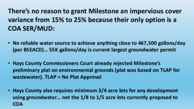
There’s no reason to grant Milestone an impervious cover variance from 15% to 25% because their only option is a COA SER/MUD: • No reliable water source to achieve anything close to 467,500 gallons/day (per BSEACD)… 55K gallons/day is current largest groundwater permit • Hays County Commissioners Court already rejected Milestone’s preliminary plat on environmental grounds (plat was based on TLAP for wastewater). TLAP = No Plat Approval • Hays County also requires minimum 3/4 acre lots for any development using groundwater… not the 1/8 to 1/5 acre lots currently proposed to COA Milestone’s argument that “they can’t make money” unless the SOS Variance is granted is FALSE They previously submitted a preliminary plat to Hays County which complied with SOS Ordinance (condo- based plat). Milestone may have gotten at the prospect of a COA SER/MUD based on high density development of single-family homes over the recharge zone Milestone would have trouble finding a decent $$ buyer for the land now because their plat rejection was all over the news: If the SOS Ordinance variance doesn’t make sense for COA, then initiating the process of the SOS Ordinance variance doesn’t make sense either
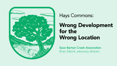
Hays Commons: Wrong Development for the Wrong Location Save Barton Creek Association Brian Zabcik, advocacy director Recharge Zone for Edwards Aquifer & Barton Springs Hays Commons COA Water Quality Protection Lands
CODES AND ORDINANCES JOINT COMMITTEE Approved 2025 Meeting Calendar Dates: Third Wednesdays Time: 6:00 p.m. Permitting and Development Center (PDC) – Room #2103 6310 Wilhelmina Delco Drive Austin, TX 78752 Third Wednesday Dates: • January 15 • February 19 • March 19 • April 16 • May 21 • June 18 • July 16 • August 20 • September 17 • October 15 • November 19 • December 17