Meeting of the Codes and Ordinances Joint Committee August 17, 2022 at 6:00 p.m. Street Jones Building – Room #400A 1000 E. 11th St, Austin, TX 78702 Some members of the Codes and Ordinances Joint Committee may be participating by video conference. Public comment will be allowed in-person or remotely by telephone. Speakers may only register to speak on an item once, either in-person or remotely, and will be allowed up to three minutes to provide their comments. Registration no later than noon the day before the meeting is required for remote participation. To register, call or email the board liaison at 512-974-3509 or greg.dutton@austintexas.gov CURRENT COMMITTEE MEMBERS Nadia Barrera-Ramirez (Chair) Claire Hempel (Vice-Chair) Awais Azhar Todd Shaw Ann Denkler Jolene Kiolbassa Greg Anderson CALL TO ORDER PUBLIC COMMUNICATION: GENERAL Speakers signed up prior to commencement of the meeting will be allowed to address their concerns regarding items not posted on the agenda. APPROVAL OF MINUTES 1. Approval of the June 15, 2022, meeting minutes. DISCUSSION AND ACTION ITEMS 2. Election of Officers. Elect a chair and vice-chair of the Codes and Ordinances Joint Committee. 3. Environmental, Drainage, and Landscape Amendments. Discuss and consider a recommendation for adoption of an ordinance amending Title 25 of the City Code relating to environmental, drainage, and landscape requirements. City Staff: Liz Johnston, Watershed Protection Department, (512) 974-2619, Liz.Johnston@austintexas.gov Facilitator: Chair Barrera-Ramirez City Attorney: None 1 4. North Burnet/Gateway Regulating Plan Subdistrict. Discuss and consider a recommendation for adoption of an ordinance amending Title 25 of the City Code to modify the Commercial Mixed Use – Gateway Zone Subdistrict of the North Burnet/Gateway Regulating Plan, to increase the maximum floor-area ratio (FAR) and building height when using a development bonus. City Staff: Jorge Rousselin, Housing and Planning Department, (512) 974-2975, Jorge.Rousselin@austintexas.gov DISCUSSION ITEMS 5. Update on Potential Upcoming and Current Code Amendments – City Staff: Greg Dutton, Housing and Planning and Department, (512) 974-3509, Greg.Dutton@austintexas.gov. FUTURE AGENDA ITEMS Future agenda items will NOT be discussed at the current meeting, but will be offered for initiation, discussion, and/or possible recommendation to the full Planning Commission at a FUTURE meeting. ADJOURNMENT The City of Austin is committed to compliance with the American with Disabilities Act. Reasonable modifications and equal access to communications will be provided upon request. Meeting locations are planned with wheelchair access. If requiring Sign Language Interpreters or alternative formats, please give notice at …
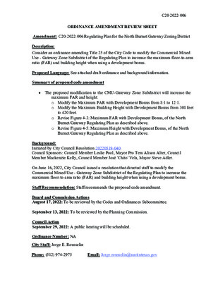
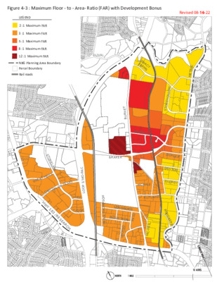
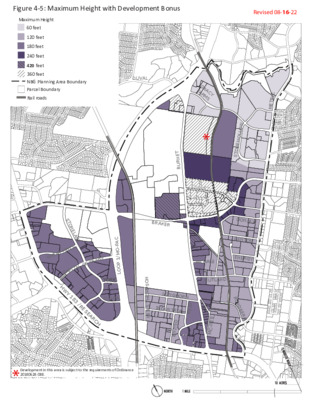
C20-2022-006 ORDINANCE AMENDMENT REVIEW SHEET Amendment: C20-2022-006 Regulating Plan for the North Burnet/Gateway Zoning District Description: Consider an ordinance amending Title 25 of the City Code to modify the Commercial Mixed Use - Gateway Zone Subdistrict of the Regulating Plan to increase the maximum floor-to-area ratio (FAR) and building height when using a development bonus. Proposed Language: See attached draft ordinance and background information. Summary of proposed code amendment • The proposed modification to the CMU-Gateway Zone Subdistrict will increase the maximum FAR and height: o Modify the Maximum FAR with Development Bonus from 8:1 to 12:1. o Modify the Maximum Building Height with Development Bonus from 308 feet to 420 feet. o Revise Figure 4-3: Maximum FAR with Development Bonus, of the North Burnet/Gateway Regulating Plan as described above. o Revise Figure 4-5: Maximum Height with Development Bonus, of the North Burnet/Gateway Regulating Plan as described above. Background: Initiated by City Council Resolution 20220519-040. Council Sponsors: Council Member Leslie Pool, Mayor Pro Tem Alison Alter, Council Member Mackenzie Kelly, Council Member José 'Chito' Vela, Mayor Steve Adler. On June 16, 2022, City Council issued a resolution that directed staff to modify the Commercial Mixed Use - Gateway Zone Subdistrict of the Regulating Plan to increase the maximum floor-to-area ratio (FAR) and building height when using a development bonus. Staff Recommendation: Staff recommends the proposed code amendment. Board and Commission Actions August 17, 2022: To be reviewed by the Codes and Ordinances Subcommittee. September 13, 2022: To be reviewed by the Planning Commission. Council Action September 29, 2022: A public hearing will be scheduled. Ordinance Number: NA City Staff: Jorge E. Rousselin Phone: (512) 974-2975 Email: Jorge.rousselin@austintexas.gov Figure 4-3 : Maximum Floor - to - Area- Ra�o (FAR) with Development Bonus Revised 08-08-19 LEGEND 2 :1 Maximum FAR 3 :1 Maximum FAR 5 :1 Maximum FAR 8 :1 Maximum FAR Parcel Boundary Rail roads NBG Planning Area Boundary DUVAL G R A F A R C Y M S C I R T E M W O L L O H E N O T S DONLEY DENTON ENERGY R U N D B E R G T E N R U B KRAMER BRAKER MCHALE RUTLAND N O S P M O H T S L I E N LONGHORN INDUSTRIAL D I E R D E T I N U L I E N - C M G …
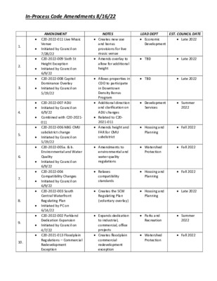
In‐Process Code Amendments 8/16/22 1. 2. 3. 4. 5. 6. 7. 8. 9. 10. AMENDMENT C20‐2022‐011 Live Music Venue Initiated by Council on 7/28/22 C20‐2022‐009 Sixth St Height Exception Initiated by Council on 6/9/22 C20‐2022‐008 Capitol Dominance Overlay Initiated by Council on 5/19/22 C20‐2022‐007 ADU Initiated by Council on 6/9/22 Combined with C20‐2021‐ 011 C20‐2022‐006 NBG CMU subdistrict change Initiated by Council on 5/19/22 Environmental and Water Quality Initiated by Council on 6/9/22 C20‐2022‐004 Compatibility Changes Initiated by Council on 6/9/22 C20‐2022‐003 South Central Waterfront Regulating Plan Initiated by PC on 6/14/22 C20‐2022‐002 Parkland Dedication Expansion Initiated by Council on 4/7/22 C20‐2021‐013 Floodplain Regulations – Commercial Redevelopment Exception NOTES Creates new use and bonus provisions for live music venue Amends overlay to allow for additional height Allows properties in CDO to participate in Downtown Density Bonus Program Additional direction and clarification on ADU changes Related to C20‐ 2021‐011 Amends height and FAR for CMU subdistrict environmental and water quality regulations Relaxes compatibility standards Creates the SCW Regulating Plan (voluntary overlay) Expands dedication to industrial, commercial, office projects Creates floodplain commercial redevelopment exception LEAD DEPT Economic EST. COUNCIL DATE Late 2022 Development TBD Late 2022 TBD Late 2022 Development Services Summer 2022 Housing and Planning Fall 2022 Housing and Planning Fall 2022 Housing and Planning Late 2022 Parks and Recreation Summer 2022 Watershed Protection Fall 2022 C20‐2022‐005a. & b. Amendments to Fall 2022 Watershed Protection In‐Process Code Amendments 8/16/22 NOTES LEAD DEPT EST. COUNCIL DATE C20‐2021‐012 Residential Allows residential Late 2022 Housing and Planning C20‐2021‐011 ADU Expands Development Services Summer 2022 AMENDMENT Initiated by PC on 12/14/21 in Commercial Initiated by Council on 12/9/21 Expansion Initiated by Council on 12/9/21 C20‐2021‐014 Project Connect Initiated by Council on 10/29/22 C20‐2021‐006 Vertical Mixed Use Affordable Housing Initiated by PC on 7/27/21 Initiated by Council on 11/18/21 C20‐2021‐004 Great Streets Fee‐In‐Lieu Mechanism Initiated by Council 8/22/19 C20‐2021‐003 Downtown Density Bonus Updates Initiated by Council on 4/22/21 C20‐2021‐002 Affordability Unlocked Site Plan Changes …
2022 Environmental Code Amendments Phase 1 Codes and Ordinances Joint Committee A u g u s t 1 7 , 2 0 2 2 C I T Y O F A U S T I N W A T E R S H E D P R O T E C T I O N D E P A R T M E N T Objective • Respond to por tion of Resolution 20220609- 061 that requires staff to bring for th an ordinance related to environmental protection in September amending Title 25 • Key subject areas Stormwater Landscape • • • Water Resource Protection Colorado River Protections • Previously identified minor code amendments and other amendments that meet the • objectives of the resolution Incentivize Missing Middle • C I T Y O F A U S T I N W A T E R S H E D P R O T E C T I O N D E P A R T M E N T 2 Progress So Far • Internal Water shed Protection Dept (WPD) technical staff • Input from other depar tments inc luding • Development Services Department • Austin Water • Austin Transportation • CoA Project Connect Office • Housing and Planning • Law • Environmental Commission Workgroup 7/25/2022 • Environmental Commission Update 8/3/2022 C I T Y O F A U S T I N W A T E R S H E D P R O T E C T I O N D E P A R T M E N T 3 Next Steps • 9/6/2022 - Environmental Commission • 9/13/2022 - Planning Commission • 9/29/2022 - City Council Phase 2: Greenfield Detention Requirements and Urban Slope Protection September & October Commissions • • November City Council C I T Y O F A U S T I N W A T E R S H E D P R O T E C T I O N D E P A R T M E N T 4 Stormwater “ 1 . E s t a b l i s h c r i t e r i a t h a t p r i o r i t i z e w h e n g r e e n s t o r m w a t e r m e t h o …
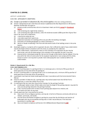
CHAPTER 25-2. ZONING. ARTICLE 9. LANDSCAPING § 25-2-981 - APPLICABILITY; EXCEPTIONS. (A) Except as provided in Subsection (B), this article applies in the city's zoning jurisdiction. (B) Division 2 (Requirements for a Site Plan) and Division 3 (Additional Site Plan Requirements in Hill Country Roadway Corridors) do not apply to: (1) property zoned central business district or downtown mixed use district, except for (Functional Green); a lot containing one single-family residence; a lot containing one duplex residence, unless the residence exceeds 4,000 square feet of gross floor (2) (3) area or has more than six bedrooms; (4) (5) (6) (7) (8) a two-family residential use; a secondary apartment special use; substantial restoration of a building within one year after the building is damaged; restoration of a building designated as a historic landmark; or interior or facade remodeling, if the front and side exterior walls of the building remain in the same location. (C) Developed property, or property with an approved site plan, that is affected by right-of-way condemnation may be developed without compliance with this article, as provided by this subsection. (1) After condemnation, improvements shown on the remainder of an approved site plan may be constructed, and only the landscaping on the remainder of the approved site plan is required. Improvements on developed properties that are lost through condemnation may be replaced. Only the area within the limits of construction for the replaced improvements must comply with this article, except an owner is not required to provide more landscaping than was in existence before the condemnation. (2) Division 2. Requirements for a Site Plan. § 25-2-1007 PARKING LOTS. (A) For each 12 parking spaces in a parking lot that is in a landscape yard, a minimum of 90 square feet of landscaped area are required within the parking lot. For each 12 parking spaces in a parking lot that is not in a landscape yard, a minimum of 60 square feet of landscaped area are required within the parking lot. (C) A parking lot must have end islands landscaped with trees in accordance with the Environmental Criteria Manual. (D) Except as provided in Subsection (E), a parking space may not be located more than 50 feet from a landscaped area, or more than 50 feet from a tree. In a parking lot that has more than three distinct modules for the parking of vehicles: (1) a landscaped median at …
Figure 4-3 : Maximum Floor - to - Area- Ratio (FAR) with Development Bonus Revised 08-15-22 LEGEND 2 :1 Maximum FAR 3 :1 Maximum FAR 5 :1 Maximum FAR 8 :1 Maximum FAR 12 :1 Maximum FAR NBG Planning Area Boundary Parcel Boundary Rail roads DUVAL G R A F A R C Y M S C I R T E M W O L L O H E N O T S DONLEY DENTON ENERGY R U N D B E R G T E N R U B KRAMER BRAKER MCHALE RUTLAND N O S P M O H T S L I E N LONGHORN INDUSTRIAL D I E R D E T I N U L I E N - C M G R E A T H I T E X A S O F S T O N E L A K E L S L C A P I T A L H W Y 1 8 C A P - O M / 1 P O O L YORK TUDOR 3 / R E S E A R C H
Figure 4-5: Maximum Height with Development Bonus Revised 08-15-22 Maximum Height LEGEND 60 feet 120 feet 180 feet 240 feet 308 feet 360 feet NBG Planning Area Boundary Parcel Boundary Rail roads DUVAL G R A F A R C Y M S * KRAMER T E N R U B C I R T E M W O L L O H E N O T S DONLEY DENTON ENERGY R U N D B E R G G R E A T H I T E X A S O F S T O N E L A K E L S L C A P I T A L H W Y 1 8 C A P - O M / 1 P O O L YORK TUDOR 3 / R E S E A R C H BRAKER MCHALE RUTLAND N O S P M O H T S L I E N LONGHORN INDUSTRIAL D I E R D E T I N U L I E N - C M 20180628-088. * Development in this area is subject to the requirements of Ordinance
RESOLUTION NO. 20220609-061 WHEREAS, protecting our environment is the foundation for sustaining our planet, community, and economy; and WHEREAS, the City ofAustin's "State of Our Environment: 2020 Annual Report," showed that creeks in the Desired Development Zone scored on average 10 points lower than those in the Drinking Water Protection Zone; and WHEREAS, the Drinking Water Protection Zone designation located on the west side of Austin has restricted development through regulations creating positive environmental outcomes, while the Desired Development Zone, located in Central and East Austin, has more permissive regulations that have resulted in some negative outcomes; and WHEREAS, properties located in the Desired Development Zone have more permissive development regulations with regard to the size of creek buffers, impervious cover limits, cut and fill, and construction on slopes; and WHEREAS, extensive empirical literature links exposure to nature with better health, and creeks provide city-wide opportunities to experience nature; and WHEREAS, current code allows for structures such as in-channel detention basins and concrete wastewater manholes to be placed in creeks, which can cause erosion and other severe, often long-lasting consequences that can be expensive to reverse; and WHEREAS, the City is faced with the existing and growing threat of industrial discharges that can negatively impact creeks and communities located primarily on the east side of the City of Austin; and Page 1 of 10 WHEREAS, there has been a steady increase in the amount of land area in Austin covered by impervious surfaces and a corresponding steady decrease in the amount of pervious land area capable of absorbing rainfall; and WHEREAS, one result of the historically high rates of development is a rise in the amount of runoff that flows off-site from developed properties and into older, undersized stormwater drain systems, creeks, rivers, and lakes, contributing to increases in flooding severity, damage to private property, loss of life, and water pollution; and WHEREAS, currently City Code allows redeveloped sites to use existing impervious cover as a baseline for drainage calculations, resulting in increased runoff and contributing to flooding and erosive flows downstream; and WHEREAS, increasing density reduces sprawl and thereby reduces traffic congestion, pollution, and development of open spaces and agricultural; and WHEREAS, a U.S. Geological Survey study found that using green stormwater infrastructure for water quality provided enhanced mitigation of peak flows and run-off volumes compared to large, detention-based stormwater control practices; and WHEREAS, the Watershed Protection Department "Master …
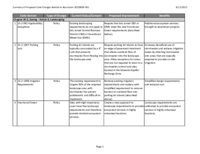
Summary of Proposed Code Changes Related to Resolution 20220609‐061 8/17/2022 Code Section Type of Change Current Status/Concern Proposed Improvement Benefits Chapter 25‐2, Zoning ‐ Article 9, Landscaping 1 25‐2‐981 Applicability; Policy Exceptions Existing landscaping requirements do not apply to lots zoned Central Business District (CBD) or Downtown Mixed Use (DMU). Require that lots zoned CBD or DMU meet the new Functional Green requirements (described below). Additional ecosystem services brought to downtown projects. 2 25‐2‐1007 Parking Policy Lots Parking lot islands are typically surrounded by a 6" curb that prevents stormwater from flowing into the landscape area. Increases beneficial use of stormwater and reduces irrigation needs by directing stormwater into areas that are typically required to provide on‐site irrigation. 3 25‐2‐1008 Irrigation Policy Requirements Simplified design requirements and reduced cost. 4 Functional Green Policy Landscape requirements are calibrated to provide ecosystem services in highly urbanized locations. Require parking lot islands to have an edge‐of‐pavement treatment that allows overland flow of stormwater into the landscape area. Allow exceptions for areas that are not required to drain to a stormwater control and sites located in the Edwards Aquifer Recharge Zone. Remove existing irrigation requirements and replace with simplified requirement to remove barriers to overland flow into parking lot islands (described above). Create a new approach to landscape requirements to provide ecosystem services in highly urbanized locations. The existing requirement to irrigate 50% of the required landscape area with stormwater has proven problematic and difficult to implement. Sites with high impervious cover have few landscape requirements and therefore provide minimal ecosystem services. Page 1 Summary of Proposed Code Changes Related to Resolution 20220609‐061 8/17/2022 Code Section Type of Change Chapter 25‐2, Zoning ‐ Article 13, Docks, Bulkheads, and Shoreline Access 5 25‐2‐1179 Clarification Current Status/Concern Environmental Protection Proposed Improvement Benefits Move bulkhead construction requirements to Chapter 25‐8, Subchapter A, Water Quality. Improves review process and clarifies intent of regulations. Bulkhead wave abatement requirements are currently located in the zoning chapter of the Land Development Code, which is inappropriate. Chapter 25‐5, Site Plans 6 25‐5‐3 Small Projects Policy Small‐scale multifamily residential projects must go through a longer, more expensive permitting process than single‐family residential projects with the same percent impervious cover. Allow multifamily residential projects with up to 11 units, or more if allowed under a qualifying Affordability Unlocked project, to follow the Small Project site plan process if they meet certain conditions. Fewer review …
Figure 4-3 : Maximum Floor - to - Area- Ratio (FAR) with Development Bonus Revised 08-16-22 LEGEND 2 :1 Maximum FAR 3 :1 Maximum FAR 5 :1 Maximum FAR 8 :1 Maximum FAR 12 :1 Maximum FAR NBG Planning Area Boundary Parcel Boundary Rail roads DUVAL G R A F A R C Y M S C I R T E M W O L L O H E N O T S DONLEY DENTON ENERGY R U N D B E R G T E N R U B KRAMER BRAKER MCHALE RUTLAND N O S P M O H T S L I E N LONGHORN INDUSTRIAL D I E R D E T I N U L I E N - C M G R E A T H I T E X A S O F S T O N E L A K E L S L C A P I T A L H W Y 1 8 C A P - O M / 1 P O O L YORK TUDOR 3 / R E S E A R C H
Figure 4-5: Maximum Height with Development Bonus Revised 08-16-22 Maximum Height LEGEND 60 feet 120 feet 180 feet 240 feet 420 feet 360 feet NBG Planning Area Boundary Parcel Boundary Rail roads DUVAL G R A F A R C Y M S * KRAMER T E N R U B C I R T E M W O L L O H E N O T S DONLEY DENTON ENERGY R U N D B E R G G R E A T H I T E X A S O F S T O N E L A K E L S L C A P I T A L H W Y 1 8 C A P - O M / 1 P O O L YORK TUDOR 3 / R E S E A R C H BRAKER MCHALE RUTLAND N O S P M O H T S L I E N LONGHORN INDUSTRIAL D I E R D E T I N U L I E N - C M 20180628-088. * Development in this area is subject to the requirements of Ordinance