ITEM02 C15-2025-0026 PRESENTATION opposition — original pdf
Backup
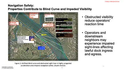
Opposition to Variances C15-2025-0026 and 0027 1 ITEM02/1-PRESENTATION Improperly Enriching Applicants at Public Expense Opposition to Variances C15-2025-0026 and 0027 2 ITEM02/2-PRESENTATION Dredge/Hardship Ignore PE-Stamped Plan & Official GIS Elevations Fig. 2. Applicants’ GIS imagery shows Official City of Austin GIS elevations Dredge charts and volumes Fig. 3. PE-Stamped Site Plan, by Aqua Permits and stamped by Mr. Hamm, shows Austin’s GIS elevations (Aug. 2025 Presentations). Opposition to Variances C15-2025-0026 and 0027 3 ITEM02/3-PRESENTATION Fig. 1. Example of Applicants’ Dredge Charts (Applicants’ Aug. & Nov. 2025 Presentations) Opposition to Variances C15-2025-0026 and 0027 ITEM02/4-PRESENTATION Lakebed Profiles Do Not Match GIS/Site Plan Inflating Dredge to Increase Dock Length Opposition to Variances C15-2025-0026 and 0027 Fig. 4. Applicants’ Lakebed Profiles Do Not Match or Average GIS/ Site Plan Elevations (Applicants’ Aug. & Nov. 2025 Dredge Charts) 5 ITEM02/5-PRESENTATION Agents Stated But Did Not Use Average End Area Calculations More Dredge -> Hardship -> More Surface Area ($0) Opposition to Variances C15-2025-0026 and 0027 6 Fig. 4 Civ. Eng. PE Review of Average End-Area Method ITEM02/6-PRESENTATION Changing Lakebed Profiles for 1750 Channel Rd. August 2025 Dredge Profile by Aqua Permits November 2025 Dredge Profile by Aqua Permits Opposition to Variances C15-2025-0026 and 0027 ITEM02/7-PRESENTATION Changing Lakebed Profiles for 1752 Channel Rd. August 2025 Dredge Profile by Aqua Permits November 2025 Dredge Profile by Aqua Permits Opposition to Variances C15-2025-0026 and 0027 ITEM02/8-PRESENTATION