ITEM07 C15-2026-0005 ADV PACKET APPELLANT PART3 — original pdf
Backup
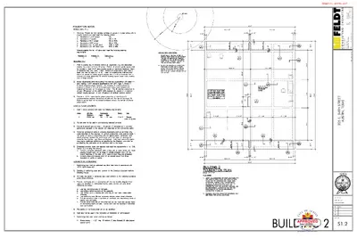
m o c . g n i t l l u s n o c t d e f @ n e b 9 9 3 1 - 3 8 5 - 2 1 5 9 3 8 6 - 8 0 3 - 2 1 5 : E N O H P : L I A M - E : X A F S R E E N G N E I G N I T L U S N O C 6 5 8 6 # . G E R M R I F . E . P . B . T 4 6 6 8 7 S A X E T , K C O R D N U O R T E E R T S N A M I . E 1 0 8 m o c . g n i t l u s n o c t d e f . l w w w : B E W 5 8 5 4 5 2 0 2 : R E B M U N B O J T E E R T S H T 4 3 . E 5 0 2 S A X E T , N I T S U A 12/9/25 CHK. BY: BTF DRWN. BY: SLM DATE: 12/09/2025 REV. DATE REV. 1 REV. 2 REV. 3 SHEET NO. S1.2 BUILDING 2 1/8/2026 REVIEWED FOR CODE COMPLIANCE ITEM07/74 - APPELLANT m o c . g n i t l l u s n o c t d e f @ n e b 9 9 3 1 - 3 8 5 - 2 1 5 9 3 8 6 - 8 0 3 - 2 1 5 : E N O H P : L I A M - E : X A F S R E E N G N E I G N I T L U S N O C 6 5 8 6 # . G E R M R I F . E . P . B . T 4 6 6 8 7 S A X E T , K C O R D N U O R T E E R T S N A M I . E 1 0 8 m o c . g n i t l u s n o c t d e f . l w w w : B E W 5 8 5 4 5 2 0 2 : R E B M U N B O J T E E R T S H T 4 3 . E 5 0 2 S A X E T , N I T S U A 12/9/25 CHK. BY: BTF DRWN. BY: SLM DATE: 12/09/2025 REV. DATE REV. 1 REV. 2 REV. 3 SHEET NO. S2.1 BUILDING 1 1/8/2026 REVIEWED FOR CODE COMPLIANCE ITEM07/75 - APPELLANT m o c . g n i t l l u s n o c t d e f @ n e b 9 9 3 1 - 3 8 5 - 2 1 5 9 3 8 6 - 8 0 3 - 2 1 5 : E N O H P : L I A M - E : X A F S R E E N G N E I G N I T L U S N O C 6 5 8 6 # . G E R M R I F . E . P . B . T 4 6 6 8 7 S A X E T , K C O R D N U O R T E E R T S N A M I . E 1 0 8 m o c . g n i t l u s n o c t d e f . l w w w : B E W 5 8 5 4 5 2 0 2 : R E B M U N B O J T E E R T S H T 4 3 . E 5 0 2 S A X E T , N I T S U A 12/9/25 CHK. BY: BTF DRWN. BY: SLM DATE: 12/09/2025 REV. DATE REV. 1 REV. 2 REV. 3 SHEET NO. S2.2 BUILDING 2 1/8/2026 REVIEWED FOR CODE COMPLIANCE ITEM07/76 - APPELLANT m o c . g n i t l l u s n o c t d e f @ n e b 9 9 3 1 - 3 8 5 - 2 1 5 9 3 8 6 - 8 0 3 - 2 1 5 : E N O H P : L I A M - E : X A F S R E E N G N E I G N I T L U S N O C 6 5 8 6 # . G E R M R I F . E . P . B . T 4 6 6 8 7 S A X E T , K C O R D N U O R T E E R T S N A M I . E 1 0 8 m o c . g n i t l u s n o c t d e f . l w w w : B E W 5 8 5 4 5 2 0 2 : R E B M U N B O J T E E R T S H T 4 3 . E 5 0 2 S A X E T , N I T S U A 12/9/25 CHK. BY: BTF DRWN. BY: SLM DATE: 12/09/2025 REV. DATE REV. 1 REV. 2 REV. 3 SHEET NO. S3.1 BUILDING 1 1/8/2026 REVIEWED FOR CODE COMPLIANCE ITEM07/77 - APPELLANT m o c . g n i t l l u s n o c t d e f @ n e b 9 9 3 1 - 3 8 5 - 2 1 5 9 3 8 6 - 8 0 3 - 2 1 5 : E N O H P : L I A M - E : X A F S R E E N G N E I G N I T L U S N O C 6 5 8 6 # . G E R M R I F . E . P . B . T 4 6 6 8 7 S A X E T , K C O R D N U O R T E E R T S N A M I . E 1 0 8 m o c . g n i t l u s n o c t d e f . l w w w : B E W 5 8 5 4 5 2 0 2 : R E B M U N B O J T E E R T S H T 4 3 . E 5 0 2 S A X E T , N I T S U A 12/9/25 CHK. BY: BTF DRWN. BY: SLM DATE: 12/09/2025 REV. DATE REV. 1 REV. 2 REV. 3 SHEET NO. S3.2 BUILDING 2 1/8/2026 REVIEWED FOR CODE COMPLIANCE ITEM07/78 - APPELLANT m o c . g n i t l l u s n o c t d e f @ n e b 9 9 3 1 - 3 8 5 - 2 1 5 9 3 8 6 - 8 0 3 - 2 1 5 : E N O H P : L I A M - E : X A F S R E E N G N E I G N I T L U S N O C 6 5 8 6 # . G E R M R I F . E . P . B . T 4 6 6 8 7 S A X E T , K C O R D N U O R T E E R T S N A M I . E 1 0 8 m o c . g n i t l u s n o c t d e f . l w w w : B E W 5 8 5 4 5 2 0 2 : R E B M U N B O J T E E R T S H T 4 3 . E 5 0 2 S A X E T , N I T S U A 12/9/25 CHK. BY: BTF DRWN. BY: SLM DATE: 12/09/2025 REV. DATE REV. 1 REV. 2 REV. 3 SHEET NO. S4.1 BUILDING 1 1/8/2026 REVIEWED FOR CODE COMPLIANCE ITEM07/79 - APPELLANT m o c . g n i t l l u s n o c t d e f @ n e b 9 9 3 1 - 3 8 5 - 2 1 5 9 3 8 6 - 8 0 3 - 2 1 5 : E N O H P : L I A M - E : X A F S R E E N G N E I G N I T L U S N O C 6 5 8 6 # . G E R M R I F . E . P . B . T 4 6 6 8 7 S A X E T , K C O R D N U O R T E E R T S N A M I . E 1 0 8 m o c . g n i t l u s n o c t d e f . l w w w : B E W 5 8 5 4 5 2 0 2 : R E B M U N B O J T E E R T S H T 4 3 . E 5 0 2 S A X E T , N I T S U A 12/9/25 CHK. BY: BTF DRWN. BY: SLM DATE: 12/09/2025 REV. DATE REV. 1 REV. 2 REV. 3 SHEET NO. S4.2 BUILDING 2 1/8/2026 REVIEWED FOR CODE COMPLIANCE ITEM07/80 - APPELLANT m o c . g n i t l l u s n o c t d e f @ n e b 9 9 3 1 - 3 8 5 - 2 1 5 9 3 8 6 - 8 0 3 - 2 1 5 : E N O H P : L I A M - E : X A F S R E E N G N E I G N I T L U S N O C 6 5 8 6 # . G E R M R I F . E . P . B . T 4 6 6 8 7 S A X E T , K C O R D N U O R T E E R T S N A M I . E 1 0 8 m o c . g n i t l u s n o c t d e f . l w w w : B E W 5 8 5 4 5 2 0 2 : R E B M U N B O J T E E R T S H T 4 3 . E 5 0 2 S A X E T , N I T S U A 12/9/25 CHK. BY: BTF DRWN. BY: SLM DATE: 12/09/2025 REV. DATE REV. 1 REV. 2 REV. 3 SHEET NO. S5.0 BUILDINGS 1&2 1/8/2026 REVIEWED FOR CODE COMPLIANCE ITEM07/81 - APPELLANT ORDINANCE NO. 040826-58 AN ORDINANCE REZONING AND CHANGING THE ZONING MAP ACCOMPANYING CHAPTER 25-2 OF THE CITY CODE TO ESTABLISH THE NORTH UNIVERSITY NEIGHBORHOOD CONSERVATION-NEIGHBORHOOD PLAN (NCCD-NP) COMBINING DISTRICT FOR THE PROPERTY WHOSE BOUNDARIES ARE 38™ STREET TO THE NORTH, SAN JACINTO BOULEVARD AND 27™ STREET TO THE SOUTH, GUADALUPE STREET TO THE WEST AND DUVAL STREET TO THE EAST, IN THE CITY OF AUSTIN, TRAVIS COUNTY, TEXAS; AND TO MODIFY CERTAIN BASE DISTRICTS IN THE NCCD-NP. BE IT ORDAINED BY THE CITY COUNCIL OF THE CITY OF AUSTIN: PART 1. The zoning map established by Section 25-2-191 of the City Code is amended to establish the North University neighborhood conservation-neighborhood plan (NCCD-NP) combining district and to add a NCCD-NP to each base zoning district within the property and to change the base zoning districts on 74 tracts of land on the property described in Zoning Case No.C14-04-0022, on file at the Neighborhood Planning and Zoning Department, as follows: Approximately 234.87 acres of land in the City of Austin, Travis County, Texas, more particularly described and identified in the attached Exhibit "A" incorporated into this ordinance, (the "Property"), generally known as the North University conservation-neighborhood plan combining district, locally known as the area bounded by 38th Street to the north, San Jacinto Boulevard and 27th Street to the south, Guadalupe Street to the west, and Duval Street to the east, in the City of Austin, Travis County, Texas, and generally identified in the map attached as Exhibit "B". PART 2. The base zoning of the 74 tracts shown in the chart below are changed from family residence (SF-3) district, multifamily residence low density (MF-2) district, multifamily residence medium density (MF-3) district, multifamily residence moderate- high density (MF-4) district, multifamily residence high density (MF-5) district, multifamily residence medium density-historic (MF-3-H) combining district, limited office (LO) district, general office (GO) district, general office-mixed use (GO-MU) combining district, neighborhood commercial (LR) district, general commercial services (CS) district, commercial-liquor sales (CS-1) district, and unzoned (UNZ) district to family residence Page 1 of 46 ITEM07/82 - APPELLANT neighborhood conservation-neighborhood plan (SF-3-NCCD-NP) combining district, multifamily residence limited density-neighborhood conservation-neighborhood plan (MF- 1-NCCD-NP) combining district, multifamily residence low density-neighborhood combining district, multifamily conservation-neighborhood plan (MF-2-NCCD-NP) residence medium density-neighborhood conservation-neighborhood plan (MF-3-NCCD- NP) combining district, multifamily residence moderate high density-neighborhood conservation-neighborhood plan (MF-4-NCCD-NP) combining district, multifamily residence high density-neighborhood conservation-neighborhood plan (MF-5-NCCD-NP) combining district, multifamily limited density-historic-neighborhood conservation-neighborhood plan (MF-1-H-NCCD-NP) combining district, multifamily residence low density-historic-neighborhood conservation-neighborhood plan (MF-2-H- NCCD-NP) residence medium density-historic- neighborhood conservation-neighborhood plan (MF-3-H-NCCD-NP) combining district, (NO-NCCD-NP) neighborhood office-neighborhood conservation-neighborhood plan combining district, limited office-neighborhood conservation-neighborhood plan (LO- NCCD-NP) combining district, community commercial-neighborhood conservation- neighborhood plan (GR-NCCD-NP) combining district, neighborhood commercial- neighborhood conservation-neighborhood plan (LR-NCCD-NP) combining district, general commercial services-neighborhood conservation-neighborhood plan (CS-NCCD- NP) combining district, and public-neighborhood conservation-neighborhood plan (P- NCCD-NP) combining district. combining district, multifamily residence TRACT APD-843 APD-846 APD-848 APD-850 APD-851 APD-852 APD-853 APD-855 APD-856 . . ADDRESS 3004-A FRUTH ST; 502 W 30TH ST 501, 503 W 30TH ST; 2910 FRUTH ST 500. 510W29THST 0 FRUTH ST (W PT OF LOT 4-7 BLK 2 OLT 73 DIV D FRUTH ADDN) 0 W 30TH ST (W TRI OF LOT 1 0-1 1 BLK 2 OLT 73 DIV D FRUTH ADDN) 0 WEST DR (PART OF LOT 2-7&10-14 * & ALLEY BLK 2 OLT 73 DIV D FRUTH ADDN) 0 W 29TH ST (E PT OF LOT 1-4,14-15 BLK 2 OLT 74 DIV D FRUTH ADDN) 0 HEMPHILL PARK (W PART OF LOT 7-9 BLK 3 OLT 73 DIV D FRUTH ADDN) 0 (LOT 5,10-14 & E PT OF LOT 6-8 & ALLEY BLK 3 OLT 73 DIV D FRUTH ADDN), 201 W 30TH ST (THE PORTION OF BLK 4, ALLEY, & ADJ W25FT OF STREET OLT 73 DIV D FRUTH ADDN THAT EXTENDS FROM THE NORTH RIGHT-OF-WAY LINE OF W 29TH ST TO THE CENTERLINE OF WALLER CREEK) FROM CS LO LO, CS UNZ UN2 UNZ MF-3, UNZ UNZ TO GR-NCCD-NP GR-NCCD-NP GR-NCCD-NP P-NCCD-NP P-NCCD-NP P-NCCD-NP P-NCCD-NP P-NCCD-NP UNZ P-NCCD-NP APD-861 3001 CEDAR ST (N 156 FT OF S 176 FT OF BENCHMARK CONDOMINIUMS AMENDED) APD-861A APD-865 3001 CEDAR ST (S 20 FT OF BENCHMARK CONDOMINIUMS AMENDED} 2807, 2809, 281 1 HEMPHILL PARK; 305 W 29TH ST; GO GO MF-4-NCCD-NP MF-4-NCCD-NP MF-5 NO-NCCD-NP Page 2 of 46 ITEM07/83 - APPELLANT TRACT GDC- 71 4A GDN- 701 A GDN- 704A GDS- 71 5A ADDRESS 2819 (E 37.79 FT LOT 2 BLK 2 OLT 14 DIV D FRUTH ADDN) GUADALUPE ST . .. . 505 W 38TH ST (E 16 FT LOT 3 BLK 2 OLT 77 DIV D LAKEVIEW ADDN) 510 W 35TH ST (E 16 FT LOT 3 BLK 1 OLT 77 DIV B STEINLE ADDN} 281 9 (E 37.79 FT AV & 1/2 ADJ 16 FT VAC ALLEY LOT 1 BLK 2 OLT 14 DIV D FRUTH ADDN RDE-783A RDE-784 RDE-794 RDE-805A 3710 TOM GREEN ST 300 E 35TH ST; 3503 GROOMS ST 3405 HELMS ST 407 E 35TH ST; 3408 (S 5 FT LOT 6 BLK 9 RESUB OF BLK 9 GROOMS ADDN), 3410, 3412 DUVAL ST RDE-807A 3305 HELMS ST; 200, 202, 204 E 33RD ST RDE-809 305 E 34TH ST RDE-810A RDE-813 RDE-818A RDE-821 RDE-825 RDE-826 RDE-827 RDE-828 RDE-829 RDE-830 RDE-831 RDE-832 RDE-833 RDE-834 RDW- 729A RDW- 737A RDW- 739A RDW-740 RDW-742 RDW- 742B RDW- 742D RDW-745 RDW-746 RDW- 748A RDW-755 RDW- 763B RDW-766 31 1 E 34TH ST 3305 TOM GREEN ST 202 E 32ND ST 400, 402 E 32ND ST; 3203 TOM GREEN ST 301 E 32ND ST 300, 302, 304, 308 MOORE BLVD; 303. 305, 309 E 32ND ST; 3110, 3112 WALLING DR; 3111 GROOMS ST 308 MOORE BLVD; 3108 WALLING DR 301 , 303, 305, 309 MOORE BLVD; 3105 GROOMS ST 311 MOORE BLVD 200, 202, 206 E 31 ST ST; 31 03 GROOMS ST 208E31STST 3100, 3102, 3104 TOM GREEN ST; 3101, 3103, 3105, 3109 WALLING DR 403, 405, 407 E 32ND ST 3116BENELVADR 403 W 38TH ST 404 W 35TH ST 405 W 35TH ST 303, 305 W 35TH ST 408, 410 W 34TH ST; 3405 FRUTH ST 400W34THST 306, 308, 310, 312 W 34TH ST 3707, 3709 CEDAR ST 3703, 3705 CEDAR ST 3405 CEDAR ST 3201 HEMPHILL PARK 31 12 WHEELER ST (S 34 FT LOT 2 MARKOVITS & DILLER ADDN) 3006, 3008 HEMPHILL PARK Page 3 of 46 FROM CS-1 TO CS-NCCD-NP LO GO CS-NCCD-NP CS-NCCD-NP CS-1 CS-NCCD-NP MF-3 MF-3 MF-4 MF-3 MF-3, MF-2 MF-4 MF-4 MF-3 MF-4 MF-3 MF-4 MF-4 MF-4 MF-4 MF-4 MF-4 MF-4 MF-4 MF-4 MF-4 MF-4 MF-4 MF-4 MF-4 MF-3 MF-4 MF-3 MF-4 MF-4 MF-3 SF-3 MF-3 MF-3 SF-3-NCCD-NP MF-1-NCCD-NP MF-3-NCCD-NP SF-3-NCCD-NP SF-3-NCCD-NP MF-3-H-NCCD- NP MF-3-NCCD-NP MF-2-NCCD-NP MF-3-NCCD-NP SF-3-NCCD-NP MF-2-NCCD-NP SF-3-NCCD-NP MF-2-NCCD-NP SF-3-NCCD-NP MF-1-NCCD-NP MF-1-NCCD-NP MF-3-NCCD-NP SF-3-NCCD-NP SF-3-NCCD-NP MF-1-NCCD-NP MF-3-NCCD-NP MF-3-NCCD-NP SF-3-NCCD-NP MF-3-NCCD-NP SF-3-NCCD-NP SF-3-NCCD-NP MF-1-NCCD-NP MF-2-NCCD-NP SF-3-NCCD-NP SF-3-NCCD-NP P-NCCD-NP SF-3-NCCD-NP SF-3-NCCD-NP ITEM07/84 - APPELLANT TRACT RDW-767 RDW-770 RDW-773 RDW-774 SD-868 SD-869A SD-870 SD-870A SD-872 SD-874 SD-879 SD-880 ADDRESS 0 HEMPHIILL PARK (1.05ACR APPROX LOT 1 BLK 2 OLT 74 DIV D ALDRIDGE PLACE) . . FROM SF-3 TO P-NCCD-NP 3105, 31 07 CEDAR ST 3013 HEMPHILL PARK 300 W 30TH ST 3706 SPEEDWAY 3704 (LOT 9 BLK 2 OLT 77 DIV D SIMMS RESUB OF BUDDINGTON SUBD) 102 W 35TH ST; 3502, 3504 SPEEDWAY 3500 SPEEDWAY MF-4 UNZ UNZ MF-4 LR MF-4 MF-4 104 E 37TH, 3701, 3703 SPEEDWAY 3410, 3412, 3414 SPEEDWAY 3121 SPEEDWAY 3105 (W1/2 OF LOT 3 BLK 15 DIV D GROOMS ADDN), 3107. 3109, 3111 SPEEDWAY; 3104 (E1/2 OF LOT 3 BLK 15 DIV D GROOMS ADDN) HELMS ST GO, MF-4 , MF-4 CS cs MF-1-NCCD-NP P-NCCD-NP P-NCCD-NP LR-NCCD-NP MF-4-NCCD-NP MF-1-NCCD-NP MF-1-H-NCCD- NP LO-NCCD-NP MF-1-NCCD-NP MF-4-NCCD-NP NO-NCCD-NP SD-880A 31 08 (S45FT OF E69FT OF LOT 5 BLK 15 DIV D GROOMS ADDN) HELMS ST CS NO-NCCD-NP SJD-886 300, 302, 304, 306 E 30TH ST; 3001 SPEEDWAY SJD-886A SJD-887 SJD-888 SJD-889 SJD-889A TD-722 TD-725 TD-726A TD-727 TD-728 WCD- 893A WCD- 893B WCD- 893C 400, 402, 404, 406 E 30TH ST 303 E 30TH ST 2911 SAN JACINTO BLVD 309, 405, 407, 409 E 30TH ST; 2827 SAN JACINTO BLVD 41 1 E 30TH ST 506 W 37TH ST 502W35THST 3401 (E 1 17.39 FT OF S CEN 65.8 FT OF BLK 6 OLT 77 DIV D BUDDINGTON SUB) GUADALUPE ST 506 (S 94.35 FT OF THE E 202.93 FT BLK 6 OLT 77 BUDDINGTON SUB LESS THE PORTION DESCRIBED IN TRACT TD-728) W 34TH ST LR, GO- MU, MF-4 MF-4 LR CS LR LR MF-4 MF-4 MF-3 CS-NCCD-NP CS-NCCD-NP CS-NCCD-NP CS-1-NCCD-NP CS-NCCD-NP CS-NCCD-NP LO-NCCD-NP MF-3-NCCO-NP CS-NCCD-NP CS CS-H-NCCD-NP 506 (62%, MORE OR LESS, OF S 94.35 FT OF E 202.93 FT BLK 6 OLT 77 BUDDINGTON SUB) W 34TH ST MF-3-H 2803 HEMPHILL PARK (N 100 FT OF S 200 FT OF W 1/2 OF LOT 10 BLK 13 OLT 13 DIV D WHITIS SUBD) 2707 HEMPHILL PARK (N 46FT OF W 1/2 OF LOT 4 & W 1/2 OF LOT 5 BLK 1 3 OLT 13 DIV D WHITIS SUBD) 2703 GUADALUPE ST; 300 W 27TH ST (LOTS 1-2 BLK 13 OLT 13 DIV D WHITIS SUBD) CS CS CS MF-2-H-NCCD- NP MF-5-NCCD-NP MF-5-NCCD-NP MF-5-NCCD-NP Page 4 of 46 ITEM07/85 - APPELLANT PART 3. Definitions. In this ordinance: ACCESSORY BUILDING means a building in which an accessory use is located that is detached from and located on the same site as a building in which a principal use is located. CIRCULAR DRIVEWAY means a cul-de-sac type driveway with one access point or a half-circular driveway with two access points. COMMERCIAL DISTRICT means the districts within the hierarchy of zoning districts from neighborhood office (NO) district through commercial-liquor sales (CS-1) district. DISTRICT means the Residential District, Speedway District, Adams Park District, San Jacinto District, Guadalupe District, Transition District, and Waller Creek/Seminary District. DRIVEWAY RUNNERS means a pair of pavement strips used as access to a parking space. EXCESS PARKING means parking spaces that exceed the parking required by Title 25 of the Code and the regulations in this ordinance. FRONT OF BUILDING means the side of a building that includes the main entrance to the building including any offset. HABITABLE SPACE has the meaning used in the Building Code. HALF-STORY means livable space that is contained between the eave and ridge of a dwelling. MANEUVERING means managing a vehicle into or out of a driveway or parking space from a public right-of-way. PEDESTRIAN-ORIENTED USES means those uses identified in Subsection (C) of Section 25-2-691 (Waterfront Overlay District Uses), Pace 5 of 46 ITEM07/86 - APPELLANT REDEVELOPMENT means development in which the value of the improvements is 50 percent of the value of all existing improvements on the site or development that requires a site plan. TANDEM PARKING means one car behind another so that one car must be moved before the other can be accessed. PART 4. The North University NCCD-NP is divided into the following districts which are more particularly identified on the map attached as Exhibit CkC'\ 1. The Residential District - includes all property not included in another district from 27th to 38lh Street and from Guadalupe Street to Duval Street. It includes Districts 1 and 1A. 2. The Speedway District - generally located along both sides of Speedway Street from 30lh Street to 381'1 Street. It includes Districts 2 and 2A. 3. The Adams Park District - generally located within one-half block of Adams Park between 29th Street and 30th Street. It includes Districts 3 and 3A. 4. The San Jacinto District - generally located in the area bounded by Duval Street, West 31st Street, Speedway and San Jacinto Street. It includes District 4. 5. The Guadalupe District - generally located along the east side of Guadalupe Street from 27lh Street to 38th Street. This district does not include single family residential zoning districts. This includes District 5. 6. The Transition District - generally located east of the northern section of the Guadalupe District from 34th Street to 38th Street. It includes District 6. 7. The Waller Creek/Seminary District - generally located from 27lh Street to 30th Street and from Speedway to the Adams Park District. It includes Districts 7, 7A, and 7B. PART 5. Permitted and Conditional Uses. 1. Residential Base Districts. a. Except as provided in this section, the permitted and conditional uses for the residential base zoning districts apply in accordance with the Code. Page 6 of 46 ITEM07/87 - APPELLANT b. Single family attached residential use is prohibited. c. Group residential use is prohibited in the Residential District, the Transition District, the San Jacinto District, and the Speedway District. d. Except as provided in Subsection e, a civic use that is 5,000 gross square feet or less is permitted. A civic use that is greater than 5,000 gross square feet is a conditional use. This does not apply to a religious assembly use or to a use in Waller Creek/Seminary district 7 and 7A. e. Religious assembly use is a permitted use. f. A drive-in service use is not permitted. Commercial Base District. Except as otherwise provided in this ordinance, the following table establishes the permitted and conditional uses for property in commercial zoning district in the North University NCCD-NP. NUNA NCCD DISTRICTS Speedway 2 Speedway 2 Speedway 2A Adams ParkS Adams Park 3A San Jacinto 4 Guada- lupeS Transition 6 CS/LR LO/NO Residential Uses Bed & Breakfast (Group 1) Bed & Breakfast (Group 2) Condominium Residential Duplex Residential Group Residential Mobile Home Residential Multifamily Residential Retirement Housing (Small Site) Retirement Housing (Large Site) Single-Family Attached Residential P P P ._ __ ._ P P C m^ P P P P P P P P P P __ P P C .. P P P P P P P _„ P<2) P(5) P P C P P C .. P P P __ P P P C P P C __ P P P P .. P P P P P P C Page 7 of 46 ITEM07/88 - APPELLANT NUNA NCCD DISTRICTS Speedway 2 Speedway 2 Speedway 2A Adams Parks Adams Park 3A San Jacinto 4 Guada- lupeS Transition 6 CS/LR LO/NO P P 2 P P __ __ _^ „ Single-Family Residential Small Lot Single-Family Residential Townhouse Residential Two-Family Residential Commercial Uses Administrative and Business Offices Agricultural Sales and Services Art Gallery Art Workshop Automotive Rentals Automotive Repair Services Automotive Sales Automotive Washing (of any type) Building Maintenance Services Business or Trade School Business Support Services Campground Carriage Stable Cocktail Lounge Commercial Blood Plasma Center Commercial Off-Street Parking Communications Services P Construction Sales and Services Consumer Convenience Services Consumer Repair Services P P P P P 2 P __ „ mf mm __ __ _„ „ P P P P 2A P P P __ __ P __ __ __ P P P Pagt : 8 of 46 P ^, P 6 P __ P __ ^_ ^_ „_ __ -_ P P P P 3 P _^ __ ^^ __ ... __ P P 3A P P P P .. __ P 4 P P C ._ .. _„ C P(D C P(1) _. P(10) Q(2) P P P P P P »» 5 P P P P(2) P(2) P(2) P(2) C P(2L __ P P P ITEM07/89 - APPELLANT NUNA NCCD DISTRICTS Speedway 2 Speedway 2 Speedway 2A Adams Park3 Adams Park 3A San Jacinto 4 Guada- lupeS Transition 6 CS/LR LO/NO Convenience Storage Drop-Off Recycling Collection Facility Electronic Prototype Assembly Equipment Repair Services Equipment Sales Exterminating Services Financial Services Food Preparation Food Sales Funeral Services General Retail Sales (Convenience) General Retail Sales (General) Hotel-Motel Indoor Entertainment Indoor Sports and Recreation Kennels Laundry Services Liquor Sales Marina Medical Offices -- Exceeding 5000 sq. ft. gross floor area Medical Offices - not exceeding 5000 sq. ft. gross floor area Monument Retail Sales Off-Site Accessory Parking Outdoor Entertainment __ P P(4) P P/C(13) P _^ ^m __ P __ __ __ __ __ __ __ •*. _^ __ _„ __ _. P „„ h» P P P P P P P P „. mm __ m^ P(6) P __ C __ „ __ __ P P(4) P P P C __ __ C P __ C ,, -- .. __ mm __ ^m ._ .. ._ fc- __ .. ^_ P(12) __ __ P P/C P P P ._ C __ _„ C P C __ _^ P P P(3) P P P C __ PdD P(10) P P C __ _„ „., __ C __ _„ __ «, Pag s 9 of 46 ITEM07/90 - APPELLANT NUNA NCCD DISTRICTS Speedway 2 Speedway 2 Speedway 2A Adams Parks Adams Park 3A San Jacinto 4 Guada- lupeS Transition 6 CS/LR LO/NO Outdoor Sports and Recreation Pawn Shop Services 3ersonal Improvement Services Personal Services Pet Services Plant Nursery Printing and Publishing Professional Office Recreational Equipment Maint. & Stor. Recreational Equipment Sales rlesearch Assembly Services Research Services Research Testing Services Research Warehousing Services Restaurant (General) Restaurant (Limited) Scrap and Salvage Service Station Software Development Special Use Historic Stables Theater Vehicle Storage Veterinary Services Industrial Uses Basic Industry Custom Manufacturing mm P P fc_ P _. P(4) P .. P C fcta P/C(13) ._ P(4) 2 _^ P(4) P(4) P P P ._ __ P .. P P/C(7) P __ P(8) P C __ P __ P(4) 2A P(4) __ „ P „ __ __ _. P „ __ 3 ._ m^ „ „ __ __ P „ „ __ P ^m __ __ ^^ 2 m^ ^m Page 10 of 46 C ._ P P P C _. P .. .. P P _. P C P ._ _- 3A C „ P P P C P P __ P __ __ __ __ __ ._ P P .« P(2) P P P ta_ P 5 __ P C __ __ 6 P P P C P .. __ _ P P __ P C P __ 4 — P(4) P(4) P(4) ITEM07/91 - APPELLANT NUNANCCD DISTRICTS Speedway 2 Speedway 2 Speedway 2A Adams Park3 Adams Park 3A San Jacinto 4 Guada- Iupe5 Transition 6 CS/LR LO/NO General Warehousing and Distribution Light Manufacturing Limited Warehousing and Distribution Recycling Center Resource Extraction Urban Farm All Other Agricultural Uses Civic Uses „ __ „ P _. 2 Administrative Services Aviation Facilities P(4) __ Camp Cemetery Club or Lodge College and University Facilities Communication Service Facilities Community Events Community Recreation (Private) Community Recreation (Public) Congregate Living Convalescent Services Convention Center Counseling Services Cultural Services Day Care Services (Commercial) Day Care Services (General) Day Care Services (Limited) __ C __ __ __ „ __ P C C P __ .. __ __ P .. 2 P __ __ C __ ._ __ C P P __ .. __ __ P __ 2A P(4) __ „ „ __ C P P(9) C P C C P Page 1 1 of 46 „ __ P __ 3A P __ ._ __ __ C C C „ „ P C C P __ „ __ __ 4 P C C C C __ __ __ P C C P P __ 3 P „ __ __ __ C __ C P P __ __ __ ^_ 5 P _, k«* .** .. C C C C -- __ __ P P C P P P 6 P -w __ fcfc __ __ C P ITEM07/92 - APPELLANT NUNA NCCD DISTRICTS Speedway 2 Speedway 2 Speedway 2A Adams Park3 Adams Park 3A San Jacinto 4 Guada- lupeS Transition 6 CS/LR LO/NO Detention Facilities Employee Recreation Family Home Group Home, Class 1 (General) Group Home, Class 1 (Limited) Group Home, Class II Guidance Services Hospital Services (General) Hospital Services (Limited) Local Utility Services Maintenance and Service Facilities Major Public Facilities Major Utility Facilities Military Installations Park and Recreation Services (General) Park and Recreation Services (Special) Postal Facilities Private Primary Educational Facilities Private Secondary Educational Facilities Public Primary Educational Facilities Public Secondary Educational Facilities Railroad Facilities Religious Assembly Residential Treatment Safety Services Transitional Housing __ ^_ „ C „ C __ p „ C P __ __ .. C .. „ .. .. __ p __ __ ^^ P P P C C P C „ __ C C __ p C C -w Page 12 of 46 „ P C P __ „ C _. _ C C C C „ p C __ P C P „ C ._ .. __ C C p p __ p __ P C P __ ._ C .. C C p p p C „ P C P .. C ,„ .. C C p p p __ C _, __ P C P C C C C __ __ .. C C C p p __ p C C ITEM07/93 - APPELLANT NUNA NCCD DISTRICTS Speedway 2 Speedway 2 Speedway 2A Adams Parks Adams Park 3A San Jacinto 4 Guada- lupe 5 Transition 6 Transportation Terminal CS/LR LO/NO All other Civic Uses _. __ „ -„ (1) Limited to 5,000 Gross Square Feet (2) Limited to south of 29th St.. (3) Limited to 10,000 Gross Square Feet (4) Limited to 2,500 Gross Square Feet (5) South of 30th St. only (6) Limited to 8,000 Gross Square Feet (7) Conditional over 3500 Square Feet (8) Limited to 2,000 Gross Square Feet (9) Indoor only (10) Limited to CS-1 only (11) Permitted only at 3001 Guadalupe (12) Permitted at 3000 Hemphill Park only (13) P under 5.000GSF - C over 5,000 SF per tenant NUNA NCCD DISTRICTS Residential Uses Bed & Breakfast (Group 1) Bed & Breakfast (Group 2) Condominium Residential Duplex Residential Waller Crk/ Seminary 7 Waller Crk/ Seminary 7A Waller Crk/ Seminary 7B P P P P P P P P P P P P Page 13 of 46 ITEM07/94 - APPELLANT NUNA NCCD DISTRICTS Group Residential Mobile Home Residential Multlfamily Residential Retirement Housing (Small Site) Retirement Housing (Large Site) Single-Family Attached Residential Single-Family Residential Small Lot Single-Family Residential Townhouse Residential Two-Family Residential Commercial Uses Administrative and Business Offices Agricultural Sales and Services Art Workshop Art Gallery Automotive Rentals Automotive Repair Services Automotive Sales Automotive Washing (of any type) Building Maintenance Services Business or Trade School Business Support Services Campground Carriage Stable Cocktail Lounge Commercial Blood Plasma Center Commercial Off-Street Parking Communications Services Construction Sales and Services Waller Crk/ Seminary 7 Waller Crk/ Seminary 7A Waller Crk/ Seminary 7B P __ P P C P __ P P 7 P(2) -, „ __ P(2) P __ P P C P __ P P 7A P P __ __ __ „ P __ P P P C P P P 7B fm __ _. ,„ „ __ ._ __ __ __ __ Page 14 of 46 ITEM07/95 - APPELLANT NUNA NCCD DISTRICTS Waller Crk/ Seminary 7 Waller Crk/ Seminary 7A Waller Crk/ Seminary 7B Consumer Convenience Services P(2) Consumer Repair Services Convenience Storage Drop-Off Recycling Collection Facility Electronic Prototype Assembly Equipment Repair Services Equipment Sales Exterminating Services Financial Services Food Preparation Food Sales Funeral Services General Retail Sales (Convenience) General Retail Sales (General) Hotel-Motel Indoor Entertainment Indoor Sports and Recreation Kennels Laundry Services Liquor Sales Marina Medical Offices -- exceeding 5000 sq. ft. gross floor area Medical Offices -- not exceeding 5000 sq. ft. gross floor area Monument Retail Sales Off-Site Accessory Parking Outdoor Entertainment Outdoor Sports and Recreation P „_ __ P P P P __ P „ P -_ „ ._ __ __ C(2) P(2) P(2) __ __ __ P(2) (3) „ __ „ „ .. „ P(D -. P(1) _. Page 15 of 46 __ __ __ __ __ __ __ „ __ __ __ „ __ .... «_ __ __ ITEM07/96 - APPELLANT NUNA NCCD DISTRICTS Pawn Shop Services Personal Improvement Services Personal Services Pet Services Plant Nursery Printing and Publishing Professional Office Recreational Equipment Maint. & Stor. Recreational Equipment Sales Research Assembly Services Research Services Research Testing Services Research Warehousing Services Restaurant (General) Restaurant (Limited) Scrap and Salvage Service Station Software Development Special Use Historic Stables Theater Vehicle Storage Veterinary Services Industrial Uses Basic Industry Custom Manufacturing General Warehousing and Distribution Light Manufacturing Limited Warehousing and Distribution Page 16 of 46 Waller Crk/ Seminary 7 Waller Crk/ Seminary 7A Waller Crk/ Seminary 7B „ __ __ __ __ __ __ __ „ __ __ __ __ „ __ __ __ __ 7 .- __ __ -. .. __ _. __ __ ._ __ _.. __ __ ,_ _. .. __ __ __ __ __ __ __ _fLQ.QL. . P/C(1) _. p p __ p __ __ 7A 7B ._ __ -. __ .. ITEM07/97 - APPELLANT NUNA NCCD DISTRICTS Recycling Center Resource Extraction Urban Farm All Other Agricultural Uses Civic Uses Administrative Services Aviation Facilities Camp Cemetery Club or Lodge College and University Facilities Communication Service Facilities Community Events Community Recreation (Private) Community Recreation (Public) Congregate Living Convalescent Services Convention Center Counseling Services Cultural Services Day Care Services (Commercial) Day Care Services (General) Day Care Services (Limited) Detention Facilities Employee Recreation Family Home Group Home, Class 1 (General) Group Home, Class 1 (Limited) Group Home, Class II Waller Crk/ Seminary 7 Waller Crk/ Seminary 7A Waller Crk/ Seminary 7B P 7 P __ P P P C „ C P P P P __ P P P — P 7A P _.. P P „ P P C __ C P P P P P P P -. P 7B P -^ __ C C C C P P P „_ » P C C -_ Pace 17 of 46 ITEM07/98 - APPELLANT NUNA NCCD DISTRICTS Guidance Services Hospital Services (General) Hospital Services (Limited) Local Utility Services Maintenance and Service Facilities Major Public Facilities Major Utility Facilities Military Installations Park and Recreation Services (General) Park and Recreation Services (Special) Postal Facilities Private Primary Educational Facilities Private Secondary Educational Facilities Public Primary Educational Facilities Public Secondary Educational Facilities Railroad Facilities Religious Assembly Residential Treatment Safety Services Transitional Housing Transportation Terminal All other Civic Uses Waller Crk/ Seminary 7 Waller Crk/ Seminary 7A Waller Crk/ Seminary 7B P C __ __ __ _. P P P P __ P __ _. _. __ __ P _« C __ __ P P P P -- P __ _. „_ „ C __ __ „ P P P P P __ __ ._ (1) P under 5.000GSF - C over 5,000 SF per tenant (2) Total commercial uses shall not exceed 10,000 SF (does not apply to accessory uses); A display window for commercial uses may not be visible from 30th St.; A commercial building entrance or sign may not be located on or visible from 30th St.; (3) Limited to temporary housing of Seminary faculty, students and staff Page 18 of 46 ITEM07/99 - APPELLANT 3. This section applies to the uses established in Section 2 of this part. a. A drive-in service use is not permitted. b. An automotive repair services use and a service station use are permitted uses on Guadalupe north of 35th Street. The maximum lot size for the use is 12,500 square feet. c. A multi-family residential use, condominium residential use, or any combination of multifamily and condominium residential uses permitted in the Guadalupe District may not exceed 75 percent of the gross floor area of all buildings constructed on a site. d. A residential use may not be located in the front 70 percent of the ground floor of a building in the Guadalupe District. e. Only residential uses may be located above the ground floor in the Transition District. f. A telecommunication tower use is a permitted or conditional use as defined by Section 25-2-839 (Telecommunication Towers) of the Code. g. A commercial use that is permitted in the Guadalupe District is permitted on Tract TD 726 if: 1) there is a five foot setback at Fruth and W. 35th Streets; 2) vehicular access is prohibited to Fruth Street; and 3) a commercial use is screened according to Section 25-2-1066 (Screening Requirements) of the Code. h. The following uses are permitted on Tract RDE 817 1) uses permitted in the neighborhood office district; and 2) a single-family residential, two-family residential, and duplex residential use. Page 19 of 46 ITEM07/100 - APPELLANT PART 6. General Provisions. Except as otherwise provided in this ordinance, the following provisions apply to all property within the NCCD-NP. This section does not apply to Waller Creek/Seminary District 7 or District 7A. 1. Pedestrian-oriented uses. A pedestrian-oriented use, a civic use, or habitable space shall be located at the front of a building on the ground floor. 2. Front of building and lot. a. Except as provided in Subsection b, a building shall front on the short side of the lot or where lots have been combined, on the side where the original short ends of the lots fronted. b. A building on a through lot located west of Speedway between West 33rd Street and West 34th Street shall front on West 33rd Street. 3. Street yard setbacks. a. Front yard setback.. The minimum front yard setback equals the average of the front yard setbacks of the principal single family buildings on the same side of the street of a block. The maximum setback may not exceed the average setback by more than five feet. b. Street side yard setbacks. Except as otherwise provided in this section, minimum street side yard setbacks are established by Exhibit "E'\ 1) On a block face that includes an alley approach, the street yard setback of the subject property may equal the average of the street yard setbacks of the buildings on adjoining lots that front the same street. In this section, a building across an alley is a building on an adjoining lot. The street side yard setback may be established by a building that contains a living unit on the ground floor that fronts on the same street. 2) If there are no adjoining buildings that contain a living unit on the ground floor that fronts on the same street to establish an average setback, then the street yard setbacks are according to the Setback Map attached as Exhibit UE". c. Notwithstanding any other provision in this section, a street side yard setback may not be less than five feet. Page 20 of 46 ITEM07/101 - APPELLANT 4. Site development standards for certain two-family residential uses. Except in the Guadalupe District, this section applies to construction of a two-family residential use on property that is located in a townhouse and condominium residence (SF-6) district or less restrictive zoning district. Except as otherwise provided in this section, construction must comply with the regulations for the family residence (SF-3) district. Construction may comply with the regulations of the district in which the use is located if construction complies with the compatibility standard of the Code. 5. Two-family residential use. a. In the Residential District, a two family residential use is permitted on a lot that is 7,000 square feet or larger and has a front lot width of at least 50 feet. b. In District 1A, a two family use is permitted on a lot that is at least 7,000 square feet or larger and has a front lot width of at least 48 feet. c. Except as otherwise provided in this section, the maximum gross floor area of the rear dwelling unit of a two-family residential use is 850 square feet. On a corner lot, the rear dwelling unit may exceed 850 square feet if: .1) living space is provided on the ground floor. 2) one unit has frontage on a north-south street; and 3) one unit has frontage on an east-west street. 6. Duplex residential use. In the Residential District, a duplex residential use is permitted on a lot that is 7,000 square feet or larger and has a front lot width of at least 50 feet. 7. Parking. a. Except as otherwise provided in this section, a parking space for a residential use may not be located in a street side yard. b. The maximum number of parking spaces in all street yards on a site is two. c. Pavement for a parking space in a front yard may not be located in front of a principal structure. Page 21 of 46 ITEM07/102 - APPELLANT d. Except for a single-family or two-family residential use, excess parking is prohibited. e. This subsection applies to an existing single-family, duplex, or two-family residential. If 400 square feet or more are added to the conditioned gross building floor area, the use must comply with current parking regulations. This includes conversion of accessory space to habitable space. f. A person may not reduce existing parking spaces to a number less than the number of spaces prescribed in the City Code for the present use nor may a person reallocate existing parking spaces to a new use unless the prior use is terminated or reduced in size. g. For a multi-family use, a parking space must be provided for each bedroom in a dwelling unit. h. For tandem parking, only one car may be parked behind one other. This provision includes a car parked in a garage or open parking area. i. The following provision applies to required parking spaces. 1) For a single-family residential use, tandem parking is permitted. 2) For a multi-family use, tandem parking is permitted if both spaces are assigned to the same unit. 3) For a duplex or two-family residential use, tandem parking is permitted if the use is less than 2,500 gross square feet. j. This section applies to a duplex or two-family residential use if there are at least five bathrooms in all buildings in which the use is located. An additional parking space is required for each new full bathroom constructed on the property. k. The parking requirements in Title 25 and this ordinance apply to a two-family or duplex residential use that is converted from a singly-family use. 8. Driveways and parking access. a. A driveway that provides four or fewer required parking spaces may be designed with gravel surfacing or using driveway runners. The Director of the Watershed Page 22 of 46 ITEM07/103 - APPELLANT Protection and Development Review Department must approve design and construction. Parking spaces must be solid pavement. b. Alley access is permitted if the access complies with applicable City regulations for turning and maneuvering into and out of parking spaces. The sum of the alley width and the distance between the property line and the parking space must equal 25 feet or more. c. The following provisions apply in all Districts except the Guadalupe District. 1) Except as otherwise provided in the section, access to a site is limited to one curb cut. Except in the Residential District, a site that has 100 feet of frontage or more may have two curb cuts. In the Residential District, a site may have two curb cuts if the site has 100 feet of frontage or more and has two dwelling units. 2) The width of a driveway for a single family residential use may not exceed: i) 12 feet from the driveway apron to the building setback line for a one lane driveway; ii) 18 feet for a two lane driveway; and iii) 24 feet from the building setback line to a parking area. 3) Except as otherwise provided in this subsection, for a commercial, civic, multifamily residential, or condominium residential use with three or more units, the maximum driveway width is the minimum allowed by the City Code. If the minimum width established by the Code is less than 20 feet, then the maximum width is 20 feet. 4) A one-lane circular driveway is permitted on lots over 100 feet wide. d. Not more than a total of two driveway lanes are permitted in all street yards of a single-family, duplex or two-family residential use. 9. Accessory buildings. Accessory buildings may not exceed 10 percent of the site area. Page 23 of 46 ITEM07/104 - APPELLANT 1 0. Fences. A fence located in a front yard may not exceed a height of four feet and shall have a ratio of open space to solid material of not less than 1 to 1.5. 11. Minimum site area for multifamily uses (square feet). RESIDENTIAL, SPEEDWAY & TRANSITION DISTRICTS Efficiency 1 Bdrm 2 Bdrm 3 Bdrm 4 Bdrm 5 Bdrm 6 Bdrm 2500 1600 1400 1200 1200 1200 3600 1600 3000 2000 1700 1400 1400 1400 4000 2000 3500 2400 2000 1600 1600 1600 4400 2400 4000 4500 2800 3200 2300 2600 1800 2000 1800 2000 1800 4800 2800 2000 5200 3200 5000 3600 2900 2200 2200 2200 5600 3600 5500 4000 3200 2400 2400 2400 6000 4000 MF-1 MF-2 MF-3 MF-4 MF-5 MF-6 NO LO/LR GO/GR/CS/CS-1 1200 1400 1600 1800 2000 2200 2400 ADAMS PARK DISTRICT MF-1 MF-2 MF-3 MF-4 MF-5 MF-6 NO LO/LR Effcy 1 Bdrm 2 Bdrm 3 Bdrm 4 Bdrm 5 Bdrm 6 Bdrm 2500 1600 1200 800 800 800 2500 1200 3000 3500 4000 4500 2000 2400 2800 3200 1500 1800 2100 2400 1000 1000 1000 3000 1400 1200 1200 1200 3500 1600 1400 1600 1400 1600 1400 4000 1800 1600 4500 2000 Page 24 of 46 5000 3600 2700 1800 1800 1800 5000 2200 5500 4000 3000 2000 2000 2000 5500 2400 ITEM07/105 - APPELLANT GO/GR/CS/CS-1 700 800 900 1000 1100 1200 1300 SAN JACINTO, GUADALUPE, SPEEDWAY 2A, & WALLER CREEK 7B DISTRICTS MF 1 MF-2 MF-3 MF-4 MF-5 MF-6 NO LO/LR Effcy 1 Bdrm 2 Bdrm 3 Bdrm 4 Bdrm 5 Bdrm 6 Bdrm 2500 1600 1200 700 700 700 2500 700 3000 20QQ 1500 800 800 800 3500 2400 1800 900 900 900 4000 4500 2800 32QQ 2100 1000 1000 1000 2400 1100 1100 1100 3000 3500 4000 4500 800 900 1000 1100 5000 3600 2700 1200 1200 1200 5000 1200 6000 4000 3000 1300 1300 1300 6000 1300 GO/GR/CS/CS-1 600 700 800 900 1000 1100 1200 PART 7. RESIDENTIAL DISTRICT. The Residential District is intended to protect the original buildings and development patterns of the neighborhood that were established for residential use. Single family homes and some of the older multi-family structures were built in the context of the traditional development patterns. New residential development should respect traditional patterns including building orientation, scale, height., setbacks and parking location. 1. Site development standards table. Except as otherwise modified in this part, the following site development regulations apply. RESIDENTIAL DISTRICT Min. lot size Min. lot width Max. FAR SF-2/SF-3 5750* 50* Duplex 0.4:1 Max. building coverage 40% SITE DEVELOPMENT STANDARDS MF-I MF-2 thru MF-3 MF-6 8000* 8000* 8000* 50* 0.5:1 45% 50* 0.5:1 50% 50* 0.5:1 55% NO 5750* 50% 0.35:1 35% Page 25 of 46 ITEM07/106 - APPELLANT RESIDENTIAL DISTRICT SF-2/SF-3 SITE DEVELOPMENT STANDARDS MF-1 MF-2 thru MF-3 MF-6 Max. impervious cover 45% 55% 60% 6?% Max height (See Height Map - Exhibit -D) Min. front setback (See Part 6. General Provisions) Max. front setback (See Part 6. General Provisions) Min. street side yard setback (Sec Part 6. General Provisions) NO 60% Min. interior side yard setback 5'** 5'** 51** .V** «»** rear setback - principal Min. structure *See Part 6. Subsections 5 & 6 (General Provisions) 10'*** 10' *** 10' *** 10" *** 10' *** **A new principal structure must be at least 10' from a principal structure on an adjacent lot ***For a through lot the rear setback is 1 5' 2. Porch setback. a. A porch may extend a maximum of eight feet in front of the front yard setback if a principal building has a setback of at least 25 feet. b. On a corner lot, a porch may extend a maximum of five feet in front of the street side yard setback. c. A porch must set back at least five feet from a property line. 3. Accessory building setbacks. a. Street yard setback - for an accessory building the minimum setback from: 1) The front property line of a residential use is 60 feet. 2) The setback map determines any other street yard setback. b. Interior side yard setback: The minimum setback from an interior side property line is five feet. Page 26 of 46 ITEM07/107 - APPELLANT c. Rear setback - the minimum setback from a rear property line abutting an alley or the South side of West 3411 St. for an accessory building that is not more than 30 feet in height, is five feet. d. A non-complying accessory building may be reconstructed at its existing location, but may not be less than three feet from the rear and interior side property lines. e. Attached Garage - An attached garage shall set back a minimum of 60 feet from the front property line. 4. On 3701 Cedar Street, the maximum number of mullifamily units is 40 units per acre. 5. On 208 E. 31st Street, the maximum number of multifamily units is 28 units per acre. 6. Compatibility standards for height and setbacks do not apply to the rear 70 feet of the common property line between 305 East 34lh Street (Tract RDE 809) and 309 E. 34th Street (Tract RDE 810-part). PART 8. SPEEDWAY DISTRICT. The Speedway District is intended to protect remaining single family buildings, encourage multi-family redevelopment compatible with nearby single family structures, enhance historical streetscape patterns, and support existing commercial uses. Area "2A" is intended to replace existing intense commercial zoning with mixed use zoning to encourage infill residential development with appropriate supporting commercial use. 1. Site development standards table. Except as otherwise modified in this part, the following site development regulations apply. SPEEDWAY DISTRICT SF-J MF-l MF-2 MF-3 MF-4 NO LO/GO LR cs SITE DEVELOPMENT STANDARDS Min. Lot Size 5750* 8000* 8000* 8000* 8000* 5750* 5750* 5750* 5750* Min. Lot Width 50* 50* 50* 50* 50* 50* 50* 50* 50* Max. FAR duplex 0.4 : 1 0.5: 1 0.5 : 1 0.75 : 1 0.75 : 1 0.5:1 0.7:1 0.5:1 2.0:1 Page 27 of 46 ITEM07/108 - APPELLANT SPEEDWAY DISTRICT SF-3 MF-1 MF-2 MF-3 MF-4 NO LO/GO LR cs SITE DEVELOPMENT STANDARDS Max. Building Coverage 40% 45% 50% 55% 60% 40% 50% 50% 95% Max. Impervious Cover 45% 55% 60% 65% 70% 60% 70% 80% 95% Max. Height (see Height Map - Exhibit D) Min. Front Setback (Sec Part 6. Genera! Provisions) Max. Front Setback Min. Street Side Yard Setback Min. Interior Side Yard Setback (See Part 6. General Provisions) (See Part 6. General Provisions) 5'** ^'** 5-** 5'** 5'** 5'** 5'** 5'** ^'** Min. Rear Setback 10'*** 10'*** 10'*** 10'*** 10'*** 10'*** 10'*** 10'*** |Q'*** * See Part 6. Subsections 5 & 6 (General Provisions) ** A new principal structure must be at least 10' from a principal structure on an adjacent lol. *** For a through lot the rear setback is 15'. 2. Porch setback. a. A porch may extend a maximum of eight feet in front of the front yard setback if a principal building has a setback of at least 25 feet. b. On a corner lot, a porch may extend a maximum of five feet in front of the street side yard setback. c. A porch must set back at least five feet from a property line. 3. Accessory building setbacks. a. Street yard setback - for an accessory building the minimum setback from: ]) The front property line of a residential use is 60 feet. Page 28 of 46 ITEM07/109 - APPELLANT 2) The setback map determines any other street yard setback. b. Interior side yard setback: The minimum setback from an interior side property line is five feet. c. A non-complying accessory building may be reconstructed at its existing location, but may not be less than three feet from the rear and interior side property lines. d. Attached Garage - An attached garage shall set back a minimum of 60 feet from the front property line. 4. Front of building. All buildings shall front onto Speedway unless they have no Speedway lot frontage. 5. Parking for a restaurant use with outdoor seating. a. This section applies to a restaurant use located at: 3706 Speedway (Tract SD 868) 3705 Speedway (Tract SD 871) 100 E. 31sl Street. (Tract SD 881) 100 E. 31st Street (Tract SD 883) 3000 University (Tract SD 883A) b. The outdoor seating area does not count against the allowable square footage for a restaurant (limited) and restaurant (general) use established in Part 5 and is not used to determine the parking requirement if: 1) The outdoor seating does not exceed 40 percent of the total seating; and 2) Not more than 10 tables are located outside. c. The outdoor seating area that exceeds 40 percent of the total seating area is counted as part of the allowable square footage for a restaurant (limited) and restaurant (general) use and is used to determine the parking requirement. 6. Development located at 3410 and 3412 Speedway (Tract SD 874) does not trigger height or setback compatibility regulations at 3414 Speedway {Tract SD 874) and 3408 Speedway (Tract 875) if the development is more than 30 feet in height. Page 29 of 46 ITEM07/110 - APPELLANT 7. The following apply to Lots 8-14, Block 6, Fruth Addition (Tracts SD 883, SD, 882A, SD 883, and SD 883A). a. The total gross floor area may not exceed 58,652 square feet. b. The maximum number of multifamily units is 50 units and 114 bedrooms. c. The parking requirement for a multifamily residential use is one space per bedroom for resident parking plus a number equal to ten percent of the resident parking for visitor parking. d. The maximum number of parking spaces allowed on the site is 139. e. Only pedestrian-oriented uses and residential living space are permitted along University Street. f. One driveway is permitted from the property to University Street. Except as otherwise provided, the maximum width of a driveway is the minimum width established by the City Code. If the minimum width established by the Code is less than 20 feet, then the maximum width is 20 feet. g. The minimum building setbacks are as follows: 1) W.31s l-14feet 2) University-15 feet 3) Alley-0 feet h. Building height. 1) Except as otherwise provided, the maximum height is 45 feet. 2) Within 30 feet of property line on West 3 1st Street, the maximum eave height is three stories and 30 feet. 3) Beyond 30 feet of the property line on West 31il Street, the maximum cave height is 40 feet. Page 30 of 46 ITEM07/111 - APPELLANT 4) Within 20 feet of the property line on West 30 Street the maximum eave height is two stories and 20 feet. vlh 5) Beyond 20 feet of the property line on West 30th Street, the maximum eave height is 40 feet. 6) The maximum eave height is 40 feet on University Street. i. Lighting on the street side of a building shall be shielded. j. Parking is prohibited in a street yard on University Street. k. A pole sign and freestanding sign are prohibited. 1. The maximum setback from University Street for a commercial use is 15 feet. 8. The following applies to Tract 880A. a. The minimum front setback is five feet. b. The minimum side yard setback is 0 feet. c. The maximum impervious cover is 95 percent. PART 9. ADAMS PARK DISTRICT. The Adams Park District is intended to encourage public use and enjoyment of Adams Park and to support public efforts to improve the park and the streets surrounding it. The district regulations allow a mix of commercial and residential uses that are oriented to face the park, that encourage pedestrian traffic, and that are compatible with nearby residential areas. 1. Site development standards table. Except as otherwise modified in this part, the following site development regulations apply. ADAMS PARK DISTRICT MF-1/ MF-2/ MF-3 MF-4 MF-5 / MF-6 NO LO GR CS & CS-1 SITE DEVELOPMENT STANDARDS Min. Lot Size 8000* 8000* 8000* 5000' 3 750* 5750* 5750* Page 31 of 46 ITEM07/112 - APPELLANT ADAMS PARK DISTRICT MF-1/ MF-2/ MF-3 MF-4 MF-5/ MF-6 NO LO Min. Lot Width 50** 50** 50** 50** 50** GR 50** SITE DEVELOPMENT STANDARDS Max. FAR 0.75 : 1 0.75 : 1 1.0: 1 0.6:1 0.75 : 1 1.0: 1 Max. Building Coverage 55% 60% 60% 50% Max. Impervious Cover 65% 70% 70% 70% 50% 80% 50% 80% Max. Height Min. Front Setback Max. Front Setback (see Height Map - Exhibit D) (see Setback Map - Exhibit E) {sec Setback Map - Exhibit P) Min. Street Side Yard Setbaek (see Setback Map - Exhibit E) Min. Interior Side Yard Setbaek 5'** 5'** ^>** 5'** 5-** 51** Min. Rear Setback 10'*** 10'*** 10'*** 10'*** 10'*** 10'*** * Sec Part 6. Subsections 5 & 6 (General Provisions) ** A new principal structure must be at least 10' from a principal structure on an adjacent lot. CS & CS-I 50** 1.0: 1 60% 80% 5'** 10'*** *** For a through lot the rear setback is 1 5'. 2. Porch setback. a. A porch may extend a maximum of eight feet in front of the front yard setback if a principal building has a setback of at least 25 feet. b. On a corner lot, a porch may extend a maximum of five feet in front of the street side yard setback. c. A porch must set back at least five feet from a property line. Page 32 of 46 ITEM07/113 - APPELLANT d. Notwithstanding Subsections a and b, the setback for a porch or patio abutting Adams Park or a street adjacent to Adams Park is five feet. 3. Accessory building setbacks. a. Street yard setback - for an accessory building the minimum setback from: 1) The front property line of a residential use is 60 feet. 2) The setback map determines any other street yard setback. b. Interior side yard setback: The minimum setback from an interior side property line is five feet. c. A non-complying accessory building may be reconstructed at its existing location, but may not be less than three feet from the rear and interior side property lines. d. Attached Garage - An attached garage shall set back a minimum of 60 feet from the front property line. 4. Front of building. a. A principal building shall front onto Adams Park. b. A building facade that fronts on Adams Park, West 29th Street, Fruth Street, or West 30th street shall have an entrance or window on each level of the building.. c. Curb cuts are not permitted on the side of a lot that faces W. 29lh, Fruth or W. 30th Streets and also faces the park unless there is no other access. d. A loading dock or service area of a building may not face Adams Park, Fruth Street or West 3 0th Street. e. Parking at the ground level may not be visible from Adams Park. Automobiles in the upper level of a parking structure must be screened from public view. 5. Parking for a restaurant use with outdoor seating. Page 33 of 46 ITEM07/114 - APPELLANT a. The outdoor seating area does not count against the allowable square footage for a restaurant (limited) and restaurant (general) use established in Part 5. 6-and is not used to determine the parking requirement if: 1) The outdoor seating does not exceed 40 percent of the total seating; and 2) Not more than 10 tables are located outside. b. The outdoor seating area that exceeds 40 percent of the total seating area is counted as part of the allowable square footage for a restaurant (limited) and restaurant (general) use and is used to determine the parking requirement. PART 10. SAN JACINTO STREET DISTRICT. The San Jacinto District is intended to encourage redevelopment of older housing stock in concert with appropriate commercial uses to foster a dense enclave of housing with supporting commercial use close to the University of Texas campus. 1. Site development standards table. Except as otherwise modified in this part, the following site development regulations apply in the San Jacinto Street District. SAN JACINTO STREET DISTRICT SITE DEVELOPMENT STANDARDS Min. Lot Size Min. Lot Width Max. FAR**** Max. Building Coverage Max. Impervious Cover***** Max. Height Min. Front Setback Max. Front Setback MF-4 8000* 50** 0.75 : 1 60% 70% CS & CS-1 5750* 50** 2.0 : I 60% 80% (see Height Map - Exhibit D) (see Setback Map - Exhibit - E) (see Setback Map - Exhibit - E ) Page 34 of 46 ITEM07/115 - APPELLANT SAN JACINTO STREET DISTRICT SITE DEVELOPMENT STANDARDS MF-4 CS & CS-1 Min. Street Side Yard Setback (sec Setback Map - Exhibit - E) Min. Interior Side Yard Setback 5' Min. Rear Setback 10'* * See Part 6. Subsections 5 & 6 (General Provisions) A new principal structure must be at least 10' from a principal structure on an adjacent lot. Except as shown on the Setback Map. ****The Max. FAR for Tract SJD-885A is 1:1.17 *****The Max. impervious cover for Tract SJD-885A is 76 % 2. Porch setback. a. A porch may extend a maximum of eight feet in front of the front yard setback if a principal building has a setback of at least 25 feet b. On a corner lot, a porch may extend a maximum of five feet in front of the street side yard setback. c. A porch must set back at least five feet from a property line. 3. Accessory building setbacks. a. Street yard setback - for an accessory building the minimum setback from: 1) The front property line of a residential use is 60 feet. 2) The setback map determines any other street yard setback. b. Interior side yard setback: The minimum setback from an interior side property Page 35 of 46 ITEM07/116 - APPELLANT line is five feet. c. A non-complying accessory building may be reconstructed at its existing location, but may not be less than three feet from the rear and interior side property lines. d. Attached Garage - An attached garage shall set back a minimum of 60 feet from the front property line. 4. Front of buildings. a. A building shall front onto San Jacinto Street, Duval Street, East 30th Street, or East 31st Street. b. A building entrance shall face the street. c. A loading dock or service area may not face the streets. 5. A parking area that is located at ground level and under a building must be screened from the street. 6. Parking for a restaurant use with outdoor seating. a. The outdoor seating area does not count against the allowable square footage for a restaurant (limited) and restaurant (general) use established in Part 5i 6-and is not used to determine the parking requirement if: 1) The outdoor seating does not exceed 40 percent of the total seating; and 2) Not more than 10 tables are located outside. b. The outdoor seating area that exceeds 40 percent of the total seating area is counted as part of the allowable square footage for a restaurant (limited) and restaurant (general) use and is used to determine the parking requirement. PART 11. GUADALUPE DISTRICT. The Guadalupe District is intended to support commercial use that serves area residents, to allow new opportunities for additional housing by permitting residential use above the first floor, to enhance the Guadalupe streetscape for pedestrian activity and to accommodate and plan for all modes of transportation. Page 36 of 46 ITEM07/117 - APPELLANT 1. Site development standards table. Except as otherwise modified in this part, the following site development regulations apply in the Guadalupe District. MF-6 8000 50 70% 80% GUADALUPE DISTRICT Min. Lot Size Min. Lot Width Max. FAR Max. Building Coverage Max. Impervious Cover Max. Height Min. Front Setback Max. Front Setback SITE DEVELOPMENT STANDARDS CS/CS-1 4000 25 2:01 95% 95% (see Height Map- Exhibit - D) (see Setback Map - Exhibit - - E) (see Setback Map - Hxhibil - E) Min. Street Side Yard Setback (see Setback Map - Exhibit - E) Min. Interior Side Yard Setback Min. Rear Setback Min. Accessory Bldg. Setback 5' 10' 10' O1 10' 101 2. This section applies to Tracts GDS 716, GDS 716A, and GDS 716B. a. Except as otherwise provided in this section the maximum height of a building is 60 feet. b. The site development regulations shown in Subsection c apply to a development Page 37 of 46 ITEM07/118 - APPELLANT project that meets the following conditions: 1) parking must not be visible from Guadalupe Street or Fruth Street except through an access driveway; 2) a minimum 80 percent of the street frontage is occupied by pedestrian oriented uses; and 3) the pedestrian oriented uses occupy at least 28 feet of the ground floor of a building. c. This subsection applies to a development project described in Subsection b. 1) The maximum height is 70 feet. 2) Except as otherwise provided in this subsection, the minimum setback from Fruth Street is ten feet. For the portion of a building that is at least 11 feet above grade at the setback, the minimum setback is three feet. 3) Except as otherwise provided in this subsection, the minimum setback from the alley is two feet. For Tract GDS 716B, there is no minimum setback. 4) The maximum F.A.R. is 3.5 to 1.0. 5) The minimum site area requirements set out in Part 6, Section 11 does not apply. 6) The maximum gross floor area requirements set out in Part 5, Section 3.c does not apply. d. Fifty percent of a building may have a maximum height of 70 feet if the same percentage of the building is reduced in height to 50 feet or less. The area that is reduced in height must include the front 5 feet of the building that is adjacent to Guadalupe Street. e. In the area above 60 feet, a parapet, screening or open space may exceed the final height of a building by an amount not greater than 10 percent of the additional height about 60 feet. 3. Front of buildings. Page 38 of 46 ITEM07/119 - APPELLANT a. If a lot fronts Guadalupe Street, a building on the lot shall front Guadalupe Street. b. A building entrance shall face Guadalupe Street. c. A loading dock or service area may not face Guadalupe Street. d. A building facade that fronts on Guadalupe Street shall have an entrance or window on each level of the building. e. A sidewalk sign is permitted. Section 25-10-153 (Sidewalk Sign in Downtown Sign District) applies to a sidewalk sign. A projecting sign is permitted. Section 25-10-129 (Downtown Sign District Regulations) applies to a projecting sign. 4. Parking for a restaurant use with outdoor seating. a. The outdoor seating area does not count against the allowable square footage for a restaurant (limited) and restaurant (general) use established in Part 5. 6-and is not used to determine the parking requirement if: 1) The outdoor seating does not exceed 40 percent of the total seating; and 2) Not more than 10 tables are located outside. b. The outdoor seating area that exceeds 40 percent of the total sealing area or that exceeds ten tables is counted as part of the allowable square footage for a restaurant (limited) and restaurant (general) use and is used to determine the parking requirement. 5. The rear setback for development at 2801 Guadalupe is 0 feet. PART 12. TRANSITION DISTRICT. The Transition District is intended to create a transition between commercial uses on Guadalupe and the single family uses on the streets that intersect Guadalupe Street. The district allows low intensity commercial uses or multi- family uses in a scale and character that respects the single family homes that lie close to this busy arterial. 1. Site development standards table. Except as otherwise modified in this part, the following site development regulations apply in the Transition District. Page 39 of 46 ITEM07/120 - APPELLANT TRANSITION DISTRICT SITE DEVEL 0PM ENT ST/ iNDARDS SF-2, SF-3 MF1,MF2 MF3.MF4 NO.LO.GO Min. Lot Size Min. Lot Widlh 5750* 50** 8000* 50** Max. FAR 0.4:1 duplex 0.5: 1 Max. Building Coverage Max. Impervious Cover 40% 45% 50% 60% 8000* 50** .75 : I 55% 65% 5750* 50** 1.0: 1 50% 80% Max. Height (See Height Map -Exhibit - D) Min. Front Setback (See Setback Map - Exhibit - E) cs 5750* 50** 2.0 : 1 60% 80% Max. Front Setback Min. Street Side Yard Setback Min. Interior Side Yard Setback (See Setback Map - Exhibit - E) (See Setback Map - Exhibit - E) 5'**+ 51*** 51*** ^'**# •v*** Min. Rear Setback 10'**** 10'**** 10'**** 10'**** 10'**** * See Part 6. Subsections 5 & 6 (General Provisions) ** See Part 6. Subsections 5 & 6 (General Provisions) *** A new principal structure must be at least 101 from a principal structure on an adjacent lot. **** Except as shown on the Setback Map. 2. Porch setback. a. A porch may extend a maximum of eight feet in front of the front yard setback if a principal building has a setback of at least 25 feet b. On a corner lot, a porch may extend a maximum of five feet in front of the street side yard setback. c. A porch must set back at least five feet from a property line. Page 40 of 46 ITEM07/121 - APPELLANT 3. Accessory building setbacks. a. Street yard setback - for an accessory building the minimum setback from: 1) The front property line of a residential use is 60 feet. 2) The setback map determines any other street yard setback. b. Interior side yard setback: The minimum setback from an interior side property line is five feet. c. A non-complying accessory building may be reconstructed at its existing location, but may not be less than three feet from the rear and interior side property lines. d. Attached Garage - An attached garage shall set back a minimum of 60 feet from the front property line. PART 13. WALLER CREEK / SEMINARY DISTRICT. The Waller Creek/Seminary District is intended to provide opportunities for continued development of the Austin Presbyterian Seminary, to provide additional housing for its students and their families, and to encourage additional housing density on adjacent tracts that lie close to the University of Tex\as. 1. Site development standards table. Except as otherwise modified in this part, the following site development regulations apply in the Waller Creek/Seminary District. WALLER C R E E K/ SEMINARY MF-3 MF-4 MF-5 MF-6 SJTE DEVELOPMENT STANDARDS Min. Lot Size 8000* 8000* 8000* 8000* Min. Lot Width 50* 50* 50* 50* Max. FAR 1 : 1*+** 1 : 1**** I . i**** Max. Building Coverage 55% 60% 60% 70% Page 41 of 46 ITEM07/122 - APPELLANT WALLER C R E E K/ SEMINARY Max. Impervious Cover SITE DEVELOPMENT STANDARDS MF-3 65% MF-4 70% MF-5 70% MF-6 80% Max. Height (see Height Map - Exhibit - D) Min. Front Setback (See Setback Map - Exhibit - H) Max. Front Setback (See Setback Map - Exhibit - H) Min. Slrecl Side Yard Setback (See Setback Map - Exhibit - E) Min. Interior Side Yard Setback Min. Rear Setback 10'* 5" JO111 * See Part 6. Subsections 5 &. 6 (General Provisions) 10" ** A new principal structure must be at least 10' from a principal structure on an adjacent lot. *** For a through lot the minimum setback is 15" **** FAR for District 7A is 2 : I 2. Porch setback . a. A porch may extend a maximum of eight feet in front of the street yard setback if a principal building has a setback of at least 25 feet b. On a corner lot, a porch may extend a maximum of five feet in front of the street side yard setback. c. A porch must set back at least five feet from a property line. 3. Accessory building setbacks. a. Street yard setback - for an accessory building the minimum setback from: Page 42 of 46 ITEM07/123 - APPELLANT 1) The front property line of a residential use is 60 feet. 2) The setback map determines any other street yard setback. b. Interior side yard setback: The minimum setback from an interior side property line is five feet. c. A non-complying accessory building may be reconstructed at its existing location, but may not be less than three feet from the rear and interior side property lines. d. Attached Garage - An attached garage shall set back a minimum of 60 feet from the front property line. 4. As long as any of the existing structures remain at 2807, 2809 and 2811 Hemphill Park and 305 W. 29lh Streets, new multifamily development thai abuts the properties may not exceed a height of 30 feet within 50 feet of a common property line. A 15 foot setback is required from the common property line. 5. The height limit on the part of District 7 north of Waller Creek is 45 feet beginning at the property line along 30lh Street and continuing to a point 23 feet inside the property line. The height on the remainder of the lot is 52 feet. The eave line may not exceed 40 feet at the 30th Street property line. Within 20 feet of the properly line along 30lh Street an intervening eave line not exceeding 20 feet above grade is required. 6. The maximum height is 70 feet in Waller Creek/Seminary District 7A. 7. This section applies to the use and site development regulations in Districts 7 and 7A. This section does not grant a variance related to the floodplain regulations. a. the maximum building cover and the maximum impervious cover is 95 percent outside the 100 year flood plain and 60 percent within the 100 year flood plain. b. In Districts 7 and 7A structured parking is permitted in the 100 year floodplain, but not the 25 year floodplain. 8. This section applies to parking requirements for the Waller Creek/Seminary District. For dwelling units associated with a college and university facilities use, one parking space per dwelling unit is required. For dorm uses, one parking space per two Page 43 of 46 ITEM07/124 - APPELLANT residents is required. For all other uses, one parking space per 1,000 square feet less the parking provided for residential uses is required. 9. For certain existing buildings, the setbacks are established as shown on Exhibit "F". 10. The minimum site area for multifamily uses (square feet). WALLER CREEK 7 DISTRICT Effcy 1 Bdrm 2 Bdrm 3 Bdrm 4 Bdrm 5 Bdrm 6 Bdrm Multifamily uses 700 800 900 1000 1100 1200 1300 WALLER CREEK 7A DISTRICT Effcy 1 Bdrm 2 Bdrm 3 Bdrm 4 Bdrm 5 Bdrm 6 Bdrm MF-3 MF-4 MF-5 MF-6 1200 1500 1800 2100 2400 2700 3000 700 700 700 800 800 800 900 900 900 1000 1100 1000 1100 1000 1100 1200 1200 1200 1300 1300 1300 11. A pedestrian-oriented use, civic use, or habitable space shall be located at the front of a building on the ground floor. 12. This section applies to driveways. a. Except as otherwise provided in this subsection, for a commercial, civic, multifamily residential, or condominium residential use with three or more units, the maximum driveway width is the minimum allowed by the City Code. b. If the minimum width established by the Code is less than 20 feet, then the maximum width is 20 feet. c. If University Avenue is vacated and becomes a private drive, then this Section does not apply. Page 44 of 46 ITEM07/125 - APPELLANT PART 14. The following applies to property at 2701 and 2717 Guadalupe Street and 2804 through 2816 Hemphill Park that are part of Tracts APD 864, APD 863, CDS 717, GDS 718, and CDS 719. 1. The property is more particularly described as follows: Tract One: A 1.070 acre tract of land, more or less, out of Lots 16-19, Block 1, Fruth Addition and out of a portion of Lot A, Hemphill Park Subdivision, in Travis County, the tract of land being more particularly described by metes and bounds in Exhibit ltG" incorporated into this ordinance, and Tract Two: A 0.794 acre tract of land, more or less, out of a 1.864 acre tract out of Lots 2, 23, 12-19, Block 1, Fruth Addition and out of a portion of Lot A, Hemphill Park Subdivision, in Travis County, the tract of land being more particularly described by metes and bounds in Exhibit "H" incorporated into this ordinance, (the "Property')- 2. The maximum number of residential units on the Property is 150 units. 3. The maximum height of a building or structure or portion of a building or structure on Tract One shall be 60 feet from ground level. 4. The maximum height of a building or structure is 40 feet on the property identified in Tract Two as a 5,410 square foot parcel of land, more particularly described by metes and bounds in Exhibit "G" generally located in the area along and adjacent to 29th Street and Hemphill Park. A height measurement taken at the southwest corner of 29th Street and Hemphill Park shall be used to determine the base line for measuring this 40-foot height. 5. The minimum site area for dwelling units on Tract Two must comply with Section 25- 2-647 of the City Code. 6. The minimum site area of Tracts One and Two when combined may not be less than the following: 468 square feet for a one bedroom dwelling unit, and 564 square feet for a dwelling unit with two or more bedrooms. 7. Access to the parking garage shall be limited to a single driveway on 29n Street and a single driveway located between 29th Street and Guadalupe Street. Page 45 of 46 ITEM07/126 - APPELLANT PART 15. This ordinance takes effect on September 6, 2004. PASSED AND APPROVED August 26 ,2004 !/{!,. Will Wynn Mayor APPROVED: ATTEST: David Allan Smith City Attorney s\JHA \jf Shirle>( A. Brown City Clerk Page 46 of 46 ITEM07/127 - APPELLANT EXHIBIT A 500 0 500 1000 1500 Feet Exhibit A: North University Neighborhood Conservation Combining District: Rezonings Approved 8/26/04 Case #014-04-0022 c* tv^ r- \\j1 'mjj Neighbortrood Planning and Zoning Department City of Austin v^'iy "i rvu&uii Legend Properties with proposed zoning changes ~o~ ABC-123 | Tract Number ITEM07/128 - APPELLANT North University NCCD: All Tracts Case# C14-04-0022 Approved on 3rd Reading 8/26/04 ' *• te^-.^--^ • ; .. ;. £;£.; ^" ^^^^.^ --; . •*&•• ADDRESS 3004-A FRUTH ST; 502 W 30TH ST 404 W 30TH ST; 3005 FRUTH ST 3004 HEMPHILL PARK; 400, 402 W30TH ST 501, 503 W30TH ST; 2910 FRUTH ST 2908 FRUTH ST 500, 510W29THST 407 W 30TH ST 0 FRUTH ST (W PT OF LOT 4-7 BLK 2 OLT 73 DIV D FRUTH ADDN) 0 W 30TH ST (W TRI OF LOT 10-1 1 BLK 2 OLT 73 DIV D FRUTH ADDN) FROM CS LO LO LO CS-1-MU LO. CS GR UN2 UNZ EXHIBIT A TO ;;:.::-.;:. GR-NCCD-NP LO-NCCD-NP LO-NCCD-NP GR-NCCD-NP CS-1-NCCD-NP GR-NCCD-NP GR-NCCD-NP P-NCCD-NP P-NCCD-NP 0 WEST DR (PART OF LOT 2-7&10-14 * & ALLEY BLK 2 OLT 73 DIV D FRUTH ADDN) 0 W 29TH ST (E PT OF LOT 1-4,14-15 BLK 2 OLT 74 DIV D FRUTH ADDN) 2902 HEMPHILL PARK; 400 W 29TH ST 0 HEMPHILL PARK (W PART OF LOT 7-9 BLK 3 OLT 73 DIV D FRUTH ADDN) 0 (LOT 5,10-14 & E PT OF LOT 6-8 & ALLEY BLK 3 OLT 73 DIV D FRUTH ADDN), 201 W 30TH ST (THE PORTION OF BLK 4. ALLEY, & ADJ W25FT OF STREET OLT 73 DIV D FRUTH ADDN THAT EXTENDS FROM THE NORTH RIGHT-OF-WAY LINE OF W 29TH ST TO THE CENTERLINE OF WALLER CREEK) 201 W 30TH ST (THE PORTION OF BLK 4, ALLEY, & ADJ W25FT OF STREET OLT 73 DIV D FRUTH ADDN THAT EXTENDS FROM THE SOUTH RIGHT-OF-WAY LINE OF W 30TH ST TO THE CENTERLINE OF WALLER CREEK) 300 W 29TH ST 3001 (LOT 1 FIRST ENGLISH LUTHERAN CHURCH SUBDIVISION SAVE AND EXCEPT A 0.315 ACRE TRACT OF LAND MORE PARTICULARLY DESCRIBED IN EXHIBIT A) WHITIS AVE 3001 (A 0.31 5 ACRE TRACT OF LAND MORE PARTICULARLY DESCRIBED IN EXHIBIT A) WHITIS AVE 3001 CEDAR ST (N 156 FT OF S 176 FT OF BENCHMARK CONDOMINIUMS AMENDED) 3001 CEDAR ST (S 20 FT OF BENCHMARK CONDOMINIUMS 2819 (LOT 3 & ADJ 16 FT VAC ALLEY BLK 2 OLT 14 DIV D FRUTH ADDN) GUADALUPE ST 2815 (LOT 1 1 BLK 1 OLT 14 DIV D FRUTH ADDN) FRUTH ST; 409 W 29TH ST 2812, 2814. 2816 HEMPHILL PARK (PART; SEE ALSO APD-864) 2812, 2814, 2816 HEMPHILL PARK (PART; SEE ALSO APD-863) 2807, 2809, 281 1 HEMPHILL PARK; 305 W 29TH ST; 301 W 29TH ST 3035, 3101 . 3105 GUADALUPE ST 3009, 3021 . 3023, 3025 GUADALUPE ST 3001 GUADALUPE ST 2927 GUADALUPE ST 2927 GUADALUPE ST 512 W29TH ST; 2909, 2915. 2927 GUADALUPE ST 2909 GUADALUPE ST 2825 (W 53FT AV LOT 2 & ADJ TRI OF LOT 1 BLK 2 OLT 14 DIV D FRUTH ADDN) GUADALUPE ST 2819 (E 37.79 FT LOT 2 BLK 2 OLT 14 DIV D FRUTH ADDN) GUADALUPE ST 371 1 GUADALUPE ST; 505 W 38TH ST (W 34 FT LOT 3 BLK 2 OLT 77 DIV DLAKEVIEW ADDN) UNZ P-NCCD-NP MF-3, UNZ P-NCCD-NP MF-3 UNZ UNZ MF-3-NCCD-NP P-NCCD-NP P-NCCD-NP P P-NCCD-NP LO-H MF-4 LO-H-NCCD-NP MF-4-NCCD-NP LO GO GO CS CS CS CS-MU-CO MF-5 MF-5 CS CS CS CS CS-1 CS CS-1 CS-1 LO-NCCD-NP MF-4-NCCD-NP MF-4-NCCD-NP CS-NCCD-NP CS-NCCD-NP CS-NCCD-NP CS-NCCD-NP NO-NCCD-NP MF-5-NCCD-NP CS-NCCD-NP CS-NCCD-NP CS-NCCD-NP CS-NCCD-NP CS-1-NCCD-NP CS-NCCD-NP CS-1-NCCD-NP CS-1-NCCD-NP CS-1 CS-NCCD-NP CS CS-NCCD-NP TRACT,. ,: APD-843 APD-844 APD-845 APD-846 APD-847 APD-848 APD-849 APD-850 APD-851 APD-852 APD-853 APD-854 APD-855 APD-856 APD-856A APD-857 APD-859 APD-860 APD-861 APD-861A APD-862 APD-862A APD-863 APD-864 APD-865 APD-866 GDC-709 GDC-709A GDC-709B GDC-710 GDC-711 GDC-712 GDC-713 GDC-714 GDC-714A GDN-701 Neighborhood Planning and Zoning Department Page 1 of 7 ITEM07/129 - APPELLANT North University NCCD: All Tracts Case# C14-04-0022 Approved on 3rd Reading 8/26/04 EXHIBIT A TRACT GDN-701A ADDRESS 505 W 38TH ST (E 16 FT LOT 3 BLK 2 OLT 77 DIV D LAKEVIEW ADDN) '- '-•r.,^\^H't-^<"vrY>^ FROM LO TO ;KV-V..:^. CS-NCCD-NP GDN-702 GDN-703 GDN-704 GDN-704A GDN-705 GDN-707 GDS-715 506 W 37TH ST: 3701 GUADALUPE ST 507 (W 35 FT LOT 3 BLK 1 OLT 77 DIV D LAKEVIEW ADDN), 509, 51 9 W 37TH ST 510-512 W 35TH ST (LOT 1&2 & W 34 FT LOT 3 LESS S 5FT BLK 1 OLT 77 DIV B STEINLE ADDN); 3501 GUADALUPE ST 510W35TH ST(E 16 FT LOT 3 BLK 1 OLT 77 DIV B STEINLE ADDN) CS CS CS GO 3401 (S 94.2 FT OF W 63.9 FT & W 1 50 FT OF S CEN 65.8 FT BLK 6 OLT 77 DIV D BUDDINGTON SUB), 3423 (W 150 FT OF THE N 155 FT BLK 6 OLT 77 DIV D BUDDINGTON SUB) GUADALUPE ST 507 (E 1 5 FT LOT 3 BLK 1 OLT 77 DIV D LAKEVIEW ADDN) W 37TH ST CS LO CS-NCCD-NP CS-NCCD-NP CS-NCCD-NP CS-NCCD-NP CS-NCCD-NP LO-NCCD-NP 2819 (LOTS 4-6 & 1/2 ADJ 16 FT VAC ALLEY BLK 2 OLT 14 DIV D FRUTH ADDN) GUADALUPE ST CS CS-NCCD-NP GDS-715A 281 9 (E 37.79 FT AV & 1/2 ADJ 16 FT VAC ALLEY LOT 1 BLK 2 OLT 14 DIV D FRUTH ADDN CS-1 CS-NCCD-NP GDS-716 GDS-716A GDS-716B GDS-717 GDS-718 GDS-719 GDS-720 RDE-777 RDE-778 RDE-779 RDE-779A RDE-780 RDE-780A RDE-780B RDE-781 RDE-782 RDE-783 RDE-783A RDE-784 RDE-785 RDE-786 RDE-787 RDE-788 RDE-789 RDE-790 RDE-791 RDE-792 RDE-793 RDE-794 RDE-795 RDE-796 RDE-797 2815 (LOTS 9-10 BLK 1 OLT 14 DIV D FRUTH ADDN) FRUTH ST 281 1 , 2827 GUADALUPE ST 2801 GUADALUPE ST 2806, 2808, 2810, 2812, 2814. 2816 HEMPHILL PARK; 2717 GUADALUPE ST (PART; SEE ALSO GDS-718 & GDS-720) 2806, 2808, 2810 HEMPHILL PARK; 2717 GUADALUPE ST (PART; SEE ALSO GDS-717 & GDS-720) 2711 GUADALUPE ST (PART; SEE ALSO GDS-720) 2806, 2808, 2810 HEMPHILL PARK; 2711 (PART; SEE ALSO GDS-719), 2717 GUADALUPE ST (PART; SEE ALSO GDS-717 & GDS-718) CS CS CS CS-MU-CO CS-NCCD-NP CS-NCCD-NP CS-NCCD-NP CS-NCCD-NP MF-6-CO MF-6-NCCD-NP CS-MU-CO CS CS-NCCD-NP CS-NCCD-NP 107E38THST 105, 107 E 38TH ST; 110 E 37TH ST 104, 106E35THST 3504 GRIFFITH ST 209 E 38TH ST 3706 GROOMS ST 3504. 3606, 3608, 3704 GROOMS ST; 3705 GRIFFITH ST; 200, 202, 204 E 35TH ST 301, 303, 305, 309, 311, 313 E 38TH 3601, 3605 GROOMS ST 3506 TOM GREEN ST 3710 TOM GREEN ST 300 E 35TH ST; 3503 GROOMS ST 3500, 3502 TOM GREEN ST; 302. 304. 306, 308 E 35TH ST 401,403, 405 E38THST 3709 TOM GREEN. ST 3707 TOM GREEN ST 400, 402, 404 E 35TH ST; 3503 TOM GREEN ST 407 E 38TH ST 409 E 38TH ST 3500, 3502, 3504. 3506, 3508 DUVAL ST 201, 203, 205, 207. 209 E 35TH ST 3405 HELMS ST 3402. 3404 GROOMS ST 200, 202, 204, 206, 208 E 34TH ST 301 , 303, 305, 307, 309, 31 1 , 31 3 E 35TH ST; 3406 TOM GREEN ST SF-3 MF-3 SF-3 MF-2 SF-3 MF-3 SF-3 SF-3 P MF-3 MF-3 MF-3 SF-3 SF-3 SF-3 MF-3 SF-3 SF-3 MF-3 SF-3 SF-3 MF-4 SF-3 SF-3 SF-3 SF-3-NCCD-NP MF-3-NCCD-NP SF-3-NCCD-NP MF-2-NCCD-NP SF-3-NCCD-NP MF-3-NCCD-NP SF-3-NCCD-NP SF-3-NCCD-NP P-NCCD-NP MF-3-NCCD-NP SF-3-NCCD-NP MF-1-NCCD-NP SF-3-NCCD-NP SF-3-NCCD-NP SF-3-NCCD-NP MF-3-NCCD-NP SF-3-NCCD-NP SF-3-NCCD-NP MF-3-NCCD-NP SF-3-NCCD-NP SF-3-NCCD-NP MF-3-NCCD-NP SF-3-NCCD-NP SF-3-NCCD-NP SF-3-NCCD-NP Neighborhood Planning and Zoning Department Page 2 of 7 ITEM07/130 - APPELLANT EXHIBIT A North University NCCD: All Tracts Case# C14-04-0022 Approved on 3rd Reading 8/26/04 __ i X&tf'f&'-^$&8ij^!-: &>-. :^^^\-^f^( Tp£'.; ADDRESS. 3401, 3403, 3405 GROOMS ST 302, 304 E 34TH ST 306, 308 E 34TH ST 3400 TOM GREEN ST; 310 E 34TH ST 401 , 403, 405 E 35TH ST; 3409 TOM GREEN STREET 3405 TOM GREEN ST; 3407 TOM GREEN ST 400, 402, 404 E 34TH ST 3400, 3402, 3406, 3408 (N 45 FT LOT 5 RESUB OF BLK 9 GROOMS ADDN) DUVAL ST 407 E 35TH ST; 3408 (S 5 FT LOT 6 BLK 9 RESUB OF BLK 9 GROOMS ADDN), 3410, 3412 DUVAL ST 201 , 203, 205, 207 E 34TH ST; 3306 GROOMS ST; 3307 HELMS ST 209 E 34TH ST 206. 208 E 33RD ST; 0 (N54FT OF LOT 9-10 BLK 19 HARRIS SIDON RESUB OF GROOMS ADDN), 3304 GROOMS ST 3305 HELMS ST; 200, 202, 204 E 33RD ST FROM MF-2 MF-3 MF-2 MF-3-H SF-3 SF-3 SF-3 SF-3 . >;.... TO _. MF-2-NCCD-NP MF-3-NCCD-NP MF-2-NCCD-NP MF-3-H-NCCD-NP SF-3-NCCD-NP SF-3-NCCD-NP SF-3-NCCD-NP SF-3-NCCD-NP MF-3 SF-3-NCCD-NP SF-3 SF-3-H SF-3 SF-3-NCCD-NP SF-3-H-NCCD-NP SF-3-NCCD-NP MF-3, MF-2 SF-3-NCCD-NP 301 E 34TH ST; 3309 GROOMS ST 305 E 34TH ST 309 E 34TH ST 311 E34THST 300, 302. 304, 306 E 33RD ST; 3300, 3304 TOM GREEN ST; 3305 GROOMS ST 401, 405 E 34TH ST; 3307 TOM GREEN ST 3306, 331 2 DUVAL ST 3305 TOM GREEN ST 400, 406, 408 E 33RD ST; 3303 TOM GREEN ST 3300 DUVAL ST 201, 203, 207, 209 E 33RD ST; 3205 HELMS ST; 3206 GROOMS ST MF-3 MF-4 MF-3 MF-4 MF-3 SF-3 SF-3 MF-3 SF-3 SF-3-H SF-3 NO-MU-H MF-3 MF-4 MF-3 MF-3 SF-3 200 E 32ND ST 3203 HELMS ST 202 E 32ND ST 208. 210 E 32ND ST; 0 (N1 10FT OF LOT 4 & N110FT OF E55FT OF LOT 3 GROOMS ADDN), 3202 GROOMS ST 300. 302, 304. 306. 308 E 32ND ST; 301. 307 E 33RD ST; 3200, 3204 TOM GREEN ST; 3205, 3207 GROOMS ST 405 E 33RD ST; 3208 (S 85FT OF LOT 8 *& W 61 FT OF S 85FT LOT 7 BLK 7 GROOMS ADDN}, 3208 (S 85FT OF LOT 6 "& E 1 1 FT OF S 85FT LOT 7 BLK 7 GROOMS ADDN), 3210 DUVAL ST 401 , 403 E 33RD ST; 3205 TOM GREEN ST 400, 402 E 32ND ST; 3203 TOM GREEN ST 3200 DUVAL ST 3203 DUVAL ST 110. 114 E 31ST ST; 3115 HELMS ST 301 E 32ND ST 300. 302. 304, 308 MOORE BLVD; 303. 305. 309 E 32ND ST; 31 10. 31 12 WALLING DR; 3111 GROOMS ST 308 MOORE BLVD; 3108 WALLING DR 301, 303, 305, 309 MOORE BLVD; 3105 GROOMS ST 311 MOORE BLVD 200, 202, 206 E 31 ST ST; 3103 GROOMS ST 208E31STST 3100, 3102, 3104 TOM GREEN ST; 3101, 3103, 3105, 3109 WALLING DR 403, 405, 407 E 32ND ST 3116BENELVADR 3101, 3103. 3111, 3115TOM GREEN ST MF-4 MF-4 MF-4 MF-4 MF-4 MF-4 MF-4 MF-4 MF-4 SF-3 MF-3 MF-3 SF-3 MF-4 MF-4 MF-4 MF-3-NCCD-NP MF-3-H-NCCD-NP MF-3-NCCD-NP MF-3-NCCD-NP MF-3-NCCD-NP SF-3-NCCD-NP SF-3-NCCD-NP MF-2-NCCD-NP SF-3-NCCD-NP SF-3-H-NCCD-NP SF-3-NCCD-NP NO-H-NCCD-NP MF-3-NCCD-NP MF-3-NCCD-NP MF-3-NCCD-NP MF-3-NCCD-NP SF-3-NCCD-NP SF-3-NCCD-NP SF-3-NCCD-NP MF-3-NCCD-NP SF-3-NCCD-NP MF-4-NCCD-NP MF-2-NCCD-NP SF-3-NCCD-NP MF-2-NCCD-NP SF-3-NCCD-NP MF-1-NCCD-NP MF-1-NCCD-NP MF-3-NCCD-NP SF-3-NCCD-NP SF-3-NCCD-NP MF-1-NCCD-NP MF-4-NCCD-NP TRACT' RDE-798 RDE-799 RDE-800 RDE-801 RDE-802 RDE-803 RDE-804 RDE-805 RDE-805A RDE-806 RDE-806A RDE-807 RDE-807A RDE-808 RDE-809 RDE-810 RDE-810A RDE-811 RDE-812 RDE-812A RDE-813 RDE-814 RDE-815 RDE-816 RDE-817 RDE-818 RDE-818A RDE-818B RDE-819 RDE-820 RDE-820A RDE-821 RDE-822 RDE-823 RDE-824 RDE-825 RDE-826 RDE-827 RDE-828 RDE-829 RDE-830 RDE-831 RDE-832 RDE-833 RDE-834 RDE-835 Neighborhood Planning and Zoning Department Page 3 of 7 ITEM07/131 - APPELLANT North University NCCD: All Tracts Case* C14-04-0022 Approved on 3rd Reading 8/26/04 ADDRESSV:..%;;:.j;.j^^^a^ J-S£^v£K • V*^^:^--:^^. 31 19 TOM GREEN ST 3126 DUVAL ST (N 100 FT BLK 6 DIV D GROOMS ADDN) 3126 DUVAL ST (S 178 FT BLK 6 DIV D GROOMS ADDN EXCLUDING W 45 FT OF S 45FT OF S 178FT BLK 6 DIV D GROOMS ADDN) 3126 DUVAL ST (W45 FT OF S 45FT OF S 178FT BLK 6 DIV D GROOMS ADDN) 404 E 31ST ST; 3102. 3104, 3106, 3100 DUVAL ST; 3103 BENELVA DR FROM MF-4 SF-3 SF-3-H SF-3 MF-4 105, 107, 109. 203. 209 E 31ST ST; 3004, 3006 SPEEDWAY 407 W 38TH ST 403 W 38TH ST 305,307,309,311,313, 315,401 W38THST 301 W38THST 408 W 37TH ST 300, 302, 304, 306, 308, 31 0, 31 2, 314, 400, 402, 404, 406 W 37TH ST MF-4 MF-3 MF-4 SF-3 MF-4 MF-3 SF-3 SF-3 301, 303, 305, 307, 309, 311, 313. 315, 401, 403, 405, 407 (N1/2 OF LOT 9 BLK 1 OLT 77 DIV D LAKEVIEW ADDN), 407 (S1/2 OF LOT 9 BLK 1 OLT 77 DIV D LAKEVIEW ADDN), 409, 41 1 W 37TH ST 500 W 35TH ST 406 W 35TH ST 400 W 35TH ST 404 W 35TH ST 300, 302, 304, 306, 308, 310 W 35TH ST 407,409,411 W35THST 405 W 35TH ST 311, 313, 315, 317, 401, 403 W35TH ST 303. 305 W 35TH ST 301 W 35TH ST 408. 410 W 34TH ST; 3405 FRUTH ST 402. 404.406W34THST 400 W 34TH ST 314,316W34THST 306, 308, 31 0, 31 2 W 34TH ST 300, 302, 304 W 34TH ST 3710 CEDAR ST 109. 111 W38THST 3711 CEDAR ST 3707, 3709 CEDAR ST 3703, 3705 CEDAR ST 3701 CEDAR ST 203, 207 W 35TH ST; 3400. 3402, 3404, 3406, 3408, 3410, 3412, 3414 CEDAR ST 1 10 W 34TH ST: 3401 CEDAR ST SF-3 3405 CEDAR ST MF-3 3407. 3409, 3411, 3413, 3415, 3417 CEDAR ST SF-3 400, 404, 406, 408, 500, 502, 504, 506, 508, 510, 512 W33RD ST; 3312 SF-3 HEMPHILL PARK; 407, 409, 41 1 , 501 , 505. 507 W 34TH ST 212W33RDST 1 12, 1 14. 200. 202, 204, 206, 208, 210 W 33RD ST; 301 , 303, 305 W 34TH ST 110W33RDST 100. 102, 104, 108W33RDST;105, 109, 115 W34TH ST SF-3 SF-3 MF-3 MF-4 SF-3 SF-3 MF-4 SF-3 MF-4 SF-3 MF-3 SF-3 MF-4 SF-3 MF-3 SF-3 SF-3-H MF-4 SF-3 MF-4 MF-4 MF-4 SF-3 SF-3-H SF-3 SF-3-H SF-3 TRACT , ^ RDE-835A RDE-836 RDE-836A RDE-836B RDE-837 RDE-838 RDW-729 RDW-729A RDW-730 RDW-731 RDW-732 RDW-733 RDW-734 RDW-735 RDW-736 RDW-737 RDW-737A RDW-738 RDW-739 RDW-739A RDW-739B RDW-740 RDW-741 RDW-742 RDW-742A RDW-742B RDW-742C RDW-742D RDW-742E RDW-743 RDW-744 RDW-744A RDW-745 RDW-746 RDW-746A RDW-747 RDW-748 RDW-748A RDW-748B RDW-749 RDW-750 RDW-751 RDW-752 RDW-753 EXHIBIT A *&:.• .:^y. TO MF-4-NCCD-NP SF-3-NCCD-NP SF-3-H-NCCD-NP SF-3-NCCD-NP MF-4-NCCD-NP MF-4-NCCD-NP MF-3-NCCD-NP MF-3-NCCD-NP SF-3-NCCD-NP MF-4-NCCD-NP MF-3-NCCD-NP SF-3-NCCD-NP SF-3-NCCD-NP SF-3-NCCD-NP SF-3-NCCD-NP MF-3-NCCD-NP MF-3-NCCD-NP SF-3-NCCD-NP SF-3-NCCD-NP SF-3-NCCD-NP SF-3-NCCD-NP MF-3-NCCD-NP SF-3-NCCD-NP SF-3-NCCD-NP SF-3-NCCD-NP SF-3-NCCD-NP SF-3-NCCD-NP MF-1-NCCD-NP SF-3-NCCD-NP SF-3-H-NCCD-NP MF-4-NCCD-NP SF-3-NCCD-NP MF-2-NCCD-NP SF-3-NCCD-NP MF-4-NCCD-NP SF-3-NCCD-NP SF-3-NCCD-NP SF-3-NCCD-NP SF-3-NCCD-NP SF-3-NCCD-NP SF-3-H-NCCD-NP SF-3-NCCD-NP SF-3-H-NCCD-NP SF-3-NCCD-NP Neighborhood Planning and Zoning Department Page 4 of 7 ITEM07/132 - APPELLANT North University NCCD: All Tracts Case# C14-04-0022 Approved on 3rd Reading 8/26/04 TRACT-:-,:, RDW-754 ADDRESS.. • , ''^^^^^^^^^^^^^^:vj^^f:-:.: 404, 406, 408, 410, 412 W32ND ST; 401, 405, 407 (LOT 38 * LESS E7FT OF BLK 5 OLT 74 DIV D ALDRIDGE PLACE), 407 (E 7FT OF LOT 38 BLK 5 OLT 74 DIV D ALDRIDGE PLACE), 501 , 503, 507 W 33RD ST; 3200, 3202, 3204, 3206, 3208, 3210 HEMPHILL PARK; 3201, 3203, 3205 GUADALUPE ST FROM •" SF-3 TO. -:•;. ,,u,. SF-3-NCCD-NP EXHIBIT A RDW-755 RDW-756 RDW-757 RDW-758 RDW-759 RDW-760 ROW- 761 RDW-762 RDW-763 RDW-763A RDW-763B RDW-764 RDW-765 RDW-766 RDW-767 RDW-768 RDW-769 RDW-770 RDW-771 RDW-772 RDW-773 RDW-774 RDW-775 RDW-775A RDW-776 RDW-776A SD-868 SD-869 SD-869A SD-870 SD-870A SD-871 SD-872 SD-873 SD-874 SD-875 SD-876 SF-3 SF-3 SF-3 SF-3 SF-3-H SF-3-H SF-3 SF-3-H SF-3 3201 HEMPHILL PARK 200, 202, 204. 206, 208 W 32ND ST; 201, 203, 205, 207, 209 W 33RD ST; 3204 LIPSCOMB ST; 3209 HEMPHILL PARK 100, 102, 104, 106, 108, 110, 112W32NDST; 101, 103, 107, 111, 113W 33RD ST; 3202, 3206 SPEEDWAY 109W33RDST 105W33RDST 415W32NDST 3120, 31 24 WHEELER ST 401 , 407 W 32ND ST; 3101 . 3103, 3105, 3107, 3109 WHEELER ST; 3102, 3104, 3106 HEMPHILL PARK 3014 HEMPHILL PARK; 3100, 3102, 3108, 3110, 3112 (LOT 2 MARKOVITS & DILLER ADDN SAVE AND EXCEPT THE S 34 FT), 3114, 31 16, 3118 WHEELER ST; 31 17 GUADALUPE ST 3006, 3008, 3010 FRUTH ST 31 12 WHEELER ST (S 34 FT LOT 2 MARKOVITS & DILLER ADDN) 3009,3011 FRUTH ST 3010 HEMPHILL PARK 3006, 3008 HEMPHILL PARK 0 HEMPHIILL PARK (1.05ACR APPROX LOT 1 BLK 2 OLT 74 DIV D ALDRIDGE PLACE) 1 03, 1 05, 1 07, 1 09, 1 1 3, 1 1 5, 1 1 7, 201 , 203, 205, 207 W 32ND ST; 31 21 , 3123, 3125 HEMPHILL PARK; 100, 102, 104, 106. 108, 110, 112, 114, 116, 118, 120, 122 LAUREL LN; 31 16 SPEEDWAY 101, 103, 105, 107, 109, 111, 113, 115. 117. 119, 121. 123 LAUREL LN; 202. 204, 208 W 31ST ST; 3100. 3102 WHITIS AVE; 3102. 3104 CEDAR ST; 3105. 3107 WHITIS AVE; 3107. 3109, 3111, 3115, 3117 HEMPHILL PARK 3105, 3107 CEDAR ST 3101 CEDAR ST 3100, 3106 SPEEDWAY 301 3 HEMPHILL PARK 300 W 30TH ST 3011 WHITIS AVE 201 W 31ST ST. 3008. 3010 CEDAR ST 3001 CEDAR ST(S 102 FT OF N 132 FT OF BENCHMARK CONDOMINIUMS AMENDED) 3001 CEDAR ST (N 30 FT OF BENCHMARK CONDOMINIUMS 3706 SPEEDWAY 3506. 3704 (LOTS 6-7 BLK 2 OLT 77 DIV D SIMMS RESUB OF BUDDINGTON SUBD) SPEEDWAY MF-4 MF-4 MF-4 UNZ UNZ MF-4 MF-4 MF-4 MF-3 MF-3 MF-3 MF-3 MF-3 SF-3 MF-4 MF-4 MF-4 SF-3 SF-3 P-NCCD-NP SF-3-NCCD-NP SF-3-NCCD-NP SF-3-H-NCCD-NP SF-3-H-NCCD-NP SF-3-NCCD-NP SF-3-H-NCCD-NP SF-3-NCCD-NP SF-3-NCCD-NP MF-3-NCCD-NP SF-3-NCCD-NP MF-3-NCCD-NP MF-3-NCCD-NP SF-3-NCCD-NP P-NCCD-NP SF-3-NCCD-NP SF-3-NCCO-NP MF-1-NCCD-NP MF-4-NCCD-NP MF-4-NCCD-NP P-NCCD-NP P-NCCD-NP MF-4-NCCD-NP MF-4-NCCD-NP MF-4-NCCD-NP MF-4-NCCD-NP LR-NCCD-NP MF-4-NCCD-NP 3704 (LOT 9 BLK 2 OLT 77 DIV D SIMMS RESUB OF BUDDINGTON SUBD) 102 W 35TH ST; 3502, 3504 SPEEDWAY 3500 SPEEDWAY 3707 SPEEDWAY 104 E 37TH. 3701, 3703 SPEEDWAY 3501 SPEEDWAY 3410. 3412, 3414 SPEEDWAY 3400, 3406, 3408 SPEEDWAY 3401 SPEEDWAY LR MF-4-NCCD-NP MF-4 MF-4 LR GO, MF-* MF-4 MF-4 MF-4 MF-4 MF-1-NCCD-NP MF-1-H-NCCD-NP LR-NCCD-NP LO-NCCD-NP MF-4-NCCD-NP MF-1-NCCD-NP MF-4-NCCD-NP MF-4-NCCD-NP Neighborhood Planning and Zoning Department Page 5 of 7 ITEM07/133 - APPELLANT North University NCCD: AM Tracts Case# C14-04-0022 Approved on 3rd Reading 8/26/04 ADDRESS;' ^;"':Ar^;v:^^ 103 E 34TH ST; 3301, 3305, 3307. 3309, 3311 SPEEDWAY; 3304 HELMS ST 101 E 33RD ST; 104 E 32ND ST; 3201 SPEEDWAY; 3202 HELMS ST FROM MF-4 TO "-/..'"'•".;&.- MF-4-NCCD-NP MF-4 MF-4-NCCD-NP EXHIBIT A 3121 SPEEDWAY 3105 (W1/2 OF LOT 3 BLK 15 DIV D GROOMS ADDN), 3107, 3109, 31 1 1 SPEEDWAY; 3104 (E1/2 OF LOT 3 BLK 15 DIV D GROOMS ADDN) HELMS ST 31 08 (S45FT OF E69FT OF LOT 5 BLK 1 5 DIV D GROOMS ADDN} HELMS ST 100-106 E 31ST ST; 3104 HELMS ST; 3101 SPEEDWAY (LOTS 1-2 BLK 1 5 DIV D GROOMS ADDN} 101 (N 30 FT OF E87FT OF LOT 8 BLK 6 OLT 73 DIV D FRUTH ADDN), 103 (N 30 FT OF W SOFT OF LOT 8 BLK 6 OLT 73 DIV D FRUTH ADDN) W31STST 101 (S 14 FT OF E87FT OF LOT 8 BLK 6 OLT 73 DIV D FRUTH ADDN), 103 (S 14 FT OF W 50 FT OF LOT 8 & W 50 FT OF LOT 9 BLK 6 OLT 73 DIV D FRUTH ADDN) W 31ST ST; 3010 UNIVERSITY AVE CS CS CS CS MF-4 MF-4 MF-4-NCCD-NP NO-NCCD-NP NO-NCCD-NP CS-NCCD-NP MF-4-NCCD-NP MF-4-NCCD-NP 3000 (N 24 FT LOT 14 & LOT 13 BLK 6 OLT 73 DIV D FRUTH ADDN), 3004, 3006, 3008 UNIVERSITY AVE 3000 UNIVERSITY AVE (S 20 FT LOT 14 BLK 6 OLT 73 DIV D FRUTH ADDN) 101, 103 E 31ST ST; 3007 UNIVERSITY AVE 3005 UNIVERSITY AVE; 100 E 30TH ST 102. 106, 110E30THST 200 E 30TH ST 202. 204, 206 E 30TH ST; 3000. 3002 SPEEDWAY 307, 31 1 . 405. 409. 41 1 E 31 ST ST; 3006, 3008 DUVAL ST 3007,3011 SPEEDWAY 300, 302, 304, 306 E 30TH ST; 3001 SPEEDWAY 400, 402, 404, 406 E 30TH ST 3000 DUVAL ST 303 E 30TH ST 2911 SAN JACINTO BLVD 309, 405, 407, 409 E 30TH ST; 2827 SAN JACINTO BLVD 411 E30THST 415E30TH ST 2906 DUVAL ST 2805 (PART OF LOT 4-6 & ADJ VAC ALLEY BLK 3 OLT 10 DIV D MOORE SUBD SAVE AND EXCEPT A 7,225 SQUARE FOOT TRACT OF LAND MORE PARTICULARLY DESCRIBED IN EXHIBIT B) SAN JACINTO BLVD; 2900 (LOTS 4-6 AND ADJ VAC ALLEY BLK 3 OLT 10 DIV D MOORE SUBD SAVE AND EXCEPT A 7,225 SQUARE FOOT TRACT OF LAND MORE PARTICULARLY DESCRIBED IN EXHIBIT B) DUVAL ST A 7,225 SQUARE FOOT TRACT OF LAND MORE PARTICULARLY DESCRIBED IN EXHIBIT B (LOCALLY KNOWN AS 2801-2805 SAN JACINTO BLVD AND 2800-2904 DUVAL ST) 501 (LOT 5 BLK 2 OLT 77 DIV D LAKEVIEW ADDN). 503 (LOT 4 * LESS N5FT OF BLK 2 OLT 77 DIV D LAKEVIEW ADDN) W 38TH ST 409 W 38TH ST 506 W 37TH ST 503. 505 W 37TH ST 501 W 37TH ST 504, 506 W 35TH ST 502 W 35TH ST CS CS CS-NCCD-NP CS-NCCD-NP MF-4 MF-4 MF-4 GO-H MF-4 MF-4 MF-4 LR, GO-MU, MF-4 MF-4 CS LR CS LR LR CS CS-1 CS MF-4-NCCD-NP MF-4-NCCD-NP MF-4-NCCD-NP GO-H-NCCD-NP MF-4-NCCD-NP MF-4-NCCD-NP MF-4-NCCD-NP CS-NCCD-NP CS-NCCD-NP CS-NCCD-NP CS-NCCD-NP CS-1-NCCD-NP CS-NCCD-NP CS-NCCD-NP CS-NCCD-NP CS-1-NCCD-NP CS-NCCD-NP CS-1 CS-1-NCCD-NP LO MF-4 MF-4 LO LO SF-3 MF-4 LO-NCCD-NP MF-4-NCCD-NP LO-NCCD-NP LO-NCCD-NP LO-NCCD-NP SF-3-NCCD-NP MF-3-NCCD-NP TRACT SD-877 SD-878 SD-879 SD-880 SD-880A SD-881 SD-882 SD-882A SD-883 SD-883A SD-884 SD-884A SD-884B SD-884C SD-884D SJD-885 SJD-885A SJD-886 SJD-886A SJD-886B SJD-887 SJD-888 SJD-889 SJD-889A SJD-889B SJD-890 SJD-891 SJD-892 TD-721 TD-721A TD-722 TD-723 TD-723A TD-724 TD-725 Neighborhood Planning and Zoning Department Page 6 of 7 ITEM07/134 - APPELLANT TRACT TD-726 TD-726A TD-727 TD-728 WCD-893 North University NCCD: All Tracts Case# C14-04-0022 Approved on 3rd Reading 8/26/04 ADDRESS";.' '.^.Vr^'iV-^-.S^^^K!*:-- ••^£:,'?££$fef ' . .ifor. :,V.-'^ 3423 GUADALUPE ST (E 1 1 7. 1 5 FT OF N 1 55 FT OF BLK 6 OLT 77 DIV D BUDDINGTON SUB) 3401 (E 117.39 FT OF S CEN 65.8 FT OF BLK 6 OLT 77 DIV D BUDDINGTON SUB) GUADALUPE ST 506 (S 94.35 FT OF THE E 202.93 FT BLK 6 OLT 77 BUDDINGTON SUB LESS THE PORTION DESCRIBED IN TRACT TD-728) W 34TH ST FROM CS MF-3 CS EXHIBIT A TO CS-NCCD-NP . : :>; CS-NCCD-NP CS-H-NCCD-NP 506 (62%, MORE OR LESS, OF S 94.35 FT OF E 202.93 FT BLK 6 OLT 77 BUDDINGTON SUB) W 34TH ST 271 1 . 2713. 271 5, 2721 , 2801 HEMPHILL PARK; 0 (E 1/2 OF LOT 4&5 BLK 13 OLT 13 DIV D WHITIS SUBD), 2710, 2712, 2714, 2800, 2802, 2804, 2808 WHITIS AVE; 300 W 27TH ST (LOT 3 & S 4FT OF W 103.5' LOT 4 BLK 13 OLT 13 DIV D WHITIS SUBD) MF-3-H MF-2-H-NCCD-NP MF-5 MF-5-NCCD-NP WCD-893A 2803 HEMPHILL PARK (N 100 FT OF S 200 FT OF W 1/2 OF LOT 10 BLK 13 OLT 13 DIV D WHITIS SUBD) CS WCD-893B WCD-893C WCD-894A WCD-894B WCD-895 WCD-895A WCD-896 WCD-897 2707 HEMPHILL PARK (N 46FT OF W 1/2 OF LOT 4 & W 1/2 OF LOT 5 BLK 13 OLT 13 DIV D WHITIS SUBD) 2703 GUADALUPE ST; 300 W27TH ST (LOTS 1-2 BLK 13 OLT 13 DIV D WHITIS SUBD) 100-1 06 E27THST 210W27THST 2910 (ALL OF BLK 5 & ALLEY & E 25 FT OF STR OLT 73 DIV D FRUTH ADDN SAVE AND EXCEPT THE N 20 FT SOUTH OF AND PARALLEL TO E 30TH ST) UNIVERSITY AVE 2910 (N 20 FT SOUTH OF AND PARALLEL TO E 30TH ST. BLK 5, ALLEY & E 25 FT OF STR OLT 73 DIV D FRUTH ADDN) UNIVERSITY AVE 103 E 30TH ST (A 2.214 ACRE TRACT OF LAND MORE PARTICULARLY DESCRIBED IN EXHIBIT C) 103 E 30TH ST (N 150 FT SOUTH OF AND PARALLEL TO E 30TH ST, THE WEST PORTION BEING 100 FT EAST OF AND PARALLEL TO UNIVERSITY AVE. SAVE AND EXCEPT THE N 20 FT SOUTH OF AND PARALLEL TO E 30TH ST, LOT A AUSTIN PRESBYTERIAN THEOLOGICAL SEMINARY ADDN) CS CS MF-5 MF-5 MF-3 MF-3 MF-4 MF-5-NCCD-NP MF-5-NCCD-NP MF-5-NCCD-NP MF-5-NCCD-NP MF-5-NCCD-NP MF-3-NCCD-NP MF-3-NCCD-NP MF-4-NCCD-NP MF-4 MF-4-NCCD-NP Neighborhood Planning and Zoning Department Page 7 of 7 ITEM07/135 - APPELLANT NORTH UNIVERSITY CONSERVATION COMBINING DISTRICT EXHIBITS FOR ZONING CASE C14-04-0022 C14-04-0022 EXHIBIT A (Tract APD-859) A 0.315 ACRE TRACT OF LAND OUT OF LOTS 14, 13, AND A PORTION OF LOT 12, BLOCK 7 OF THE FRUTH ADDITION AS RECORDED IN BOOK 2. PAGE 157 OF THE PLAT RECORDS OF TRAVIS COUNTY, TEXAS; SAID 0.315 ACRES BEING 0.038 ACRES OF LAND OUT OF AND A PART OF LOTS 11 AND 12 OF SAID BLOCK 7 AS CONVEYED TO FIRST ENGLISH LUTHERAN CHURCH BY DEED RECORDED IN VOLUME 698, PAGE 497 OF THE TRAVIS COUNTY DEED RECORDS, AND 0.277 ACRES OF LAND CONVEYED TO FIRST ENGLISH LUTHERAN CHURCH BY DEED RECORDED IN VOLUME 756, PAGE 401 OF THE TRAVIS COUNTY DEED RECORDS; SAID 0.315 ACRES BEING MORE PARTICULARLY DESCRIBED AS FOLLOWS: BEGINNING at the southwest corner of said Lot 14, said point being also in the north R.O.W. of West 30th Street; THENCE N 29° 41' E along the east line of a 16 foot wide alley vacated by instrument recorded in volume 335S, Page 1656, o1 the Deed Records of Travis County, Texas, a distance of100.00 feet to a point in the west line of said Lot 12, from which the northwest corner of Lot 12 bears N 29° 41' E, 32.00 feet; THENCE S 60° 12'E 137.00 feet to a point in the West R.O.W. of Cedar Street, and the east line of said Lot 12, from which the northeast corner of Lot 12 bears N 29° 41' E, 32.00 feet THENCE S 29° 41' W along the west R.O.W. of Cedar Street, 100.00 feet to the southeast corner of said Lot 14; THENCE N 60° 12'W along the south line of Lot 14 and being also along the North R.O.W. of West 30lh Street, 137.00 feet to the PLACE OF BEGINNING and containing 0.315 acres, more or less, locally known as 3000, 3002, and 3004 Cedar Street, and 200-204 W 30th Street in the City of Austin, Travis County, Texas. EXHIBITS (Tract SJD-892) A 7,225 SQUARE FOOT TRACT OF LAND OUT OF LOTS 4-5 AND ADJACENT VACATED ALLEY BLOCK 2 OUTLOT 10 DIVISION D MOORE SUBDIVISION BEING MORE PARTICULARLY DESCRIBED BY METES AND BOUNDS AS FOLLOWS: BEGINNING at the southwestern most point of the owner's property, said point lying in the north right- of-way line of the 2800 block of San Jacinto Boulevard, and said point also being in the common, brick wall which separates owner's property from the Mae Crockett Estate's property and from said point of beginning; THENCE N 50° 48' E 36.8 feet to a point lying in the back wall of the building; THENCE with the back wall of said building S 58' 4' E 23.3 feet to a point; THENCE continuing with the back wall of said building, N 86° 41' E 16.12 feet to the most northeasterly corner of the building;- THENCE with the east wall of said building S 3° 19' E 15.0 feet to the most southeasterly corner of the building; Exhibits A-C to All Tracts Chart (as part of Exhibit A) Page 1 of 2 ITEM07/136 - APPELLANT C14-04-0022 THENCE with the south wall of said building S 86° 41' W approximately 34 feet to a point in the south wall where said wall bears farther to the south; THENCE with said wall bearing approximately S 67° 41* W approximately 22 feet to a point, said point lying in the north right-of-way line of the 2800 block o'f San Jacinto Boulevard; THENCE with the north right-of-way line of San Jacinto Boulevard, N 38° 50' W approximately 20 feet to the point of beginning; locally known as 2801-2805 San Jacinto Boulevard and 2800-2904 Duval in the City of Austin, Travis County, Texas. EXHIBIT C (Tract WCD-896) A 2.214 ACRE TRACT OF LAND OUT OF THE J.G. DUNN SURVEY AND THE THOMAS GREY SURVEY NO. 10 IN TRAVIS COUNTY, TEXAS, BEING A PORTION OF LOT A, AUSTIN PRESBYTERIAN THEOLOGICAL SEMINARY ADDITION RECORDED IN PLAT BOOK 82, PAGES 14 THROUGH 15 INCLUSIVE OF THE PLAT RECORDS OF TRAVIS COUNTY TEXAS; SAID 2.214 ACRES BEING ALL OF SAID LOT A, SAVE AND EXCEPT THE TRACT OF U\ND MORE PARTICULARLY DESCRIBED AS FOLLOWS: Being a portion of said Lot A bounded on the north by a line one hundred and fifty feet (150.00'} south of and parallel to the north line of said Lot A, same being the south right-of-way (601) line of East 30lh Street, bounded on the east by the northwest line of Resubdivision of Reserve No. 14, Block 4 Grooms Addition, a subdivision of record found in Plat Book 1, Page 36 of said Plat Records, bounded on the south by the most southwesterly line of said Lot A, and bounded on the west by a line one hundred feet (100.00') east of and parallel to the most westerly line of said Lot A, same being the southeasterly right-of-way (60') line of University Avenue. "This document was prepared under 22 TAC 663.21, and does not reflect the results of an on the ground survey, and is not to be used to convey or establish interests in real property except those rights and interests implied or established by the creation or reconfiguration of the boundary of the political subdivision for which it was prepared." Exhibits A-C to All Tracts Chart (as part of Exhibit A) Page 2 of2 ITEM07/137 - APPELLANT SUBJECT TRACT PENDING CASE ZONING BOUNDARY CASEMGR: G.RHOADES CASE#:C14-04-0022 ADDRESS: NORTH UNIVERSITY f DATE: 04-03 INTLS: SM CITY GRID REFERENCE NUMBER J 24-25 ITEM07/138 - APPELLANT Exhibit C: North University Neighborhood 17 Conservation Combining District C14-04-0022 Approved on 3rd Reading 8/26/04 ° y City of Austin Neighborhood Planning and Zoning Department 0 250 500 eet f. In.' . f e , ^ey to Districts D , Residential District, East & West (RDE, ROW) 1 speedway District <SD> 2-2A Adams Park District (APD) 3-3A San JacmtoDistnct(SJD) 4 „>>, Guadalupe District (GDN, GDC, CDS) 5 Transition District (TD) 6 "'V^ Waller Creek/Seminary District (WCD) 7-7A-7B ITEM07/139 - APPELLANT Exhibit D: North University Neighborhood Conservation Combining District Maximum Building Height C14-04-0022 sTritf^ ^'^ °^ Austin ? f^ •' Neighborhood Planning and Zoning Department 500 250 0 Feet Legend JL ™^/E I : 30 Feet j ) 50 Feet ^^ wwvsXl 40 Fppt '*^ ' v>v>i OkXxScxxi P® 70 Feet Street '.-:<'vi Park ITEM07/140 - APPELLANT North University Neighborhood NCCD Exhibit E Street Setbacks (whereaveraging Is not applicable) ? Min. (OS1) - Max. (101) ITEM07/141 - APPELLANT ITEM07/142 - APPELLANT CARSON AND BUSH PROFESSIONAL SURVEYORS, INC. 1904 FORTVIEW ROAD AUSTIN, TX 78704 TELEPHONE: (512) 442-0990 FACSIMILE: (512) 442-1084 APRIL 16, 2001 FIELD NOTE DESCRIPTION FOR ZONING CHANGE APPLICATION OF 1.070 ACRES OF LAND, BEING A PORTION OF LOTS 16-19, BLOCK 1, FRUTH ADDITION, A SUBDIVISION IN TRAVIS COUNTY, TEXAS, ACCORDING TO THE MAP OR PLAT THEREOF RECORDED IN VOLUME 2 PAGE 157 OF THE PLAT RECORDS OF TRAVIS COUNTY, TEXAS, AND BEING A PORTION OF LOT A, HEMPHILL PARK, A SUBDIVISION IN TRAVIS COUNTY, TEXAS, ACCORDING TO THE MAP OR PLAT THEREOF RECORDED IN VOLUME 73 PAGE 33 OF THE PLAT RECORDS OF TRAVIS "COUNTY, TEXAS, AND SAID 1.070 ACRE OF LAND BEING MORE PARTICULARLY DESCRIBED BY METES AND BOUNDS AS FOLLOWS: Beginning for reference at a Vi inch iron rod found in the west right-of-way line of Hemphill Park at !he Northeast corner of Lot 16, Block 1. Fruth Addition, a subdivision in Travis County, Texas, according to the map or plat thereof recorded in Volume 2 Page 157 of the Plat Records of Travis County, Texas; Thence with the north line of said Lot 16, N 83 deg. 05' 45" W 10.19 (t. to a point at the Northeast corner and PLACE OF BEGINNING of (he herein described tract; THENCE crossing the interior of Lots 16-19, Block 1 of said Fruth Addition and of Lot A. Hemphill Park, a subdivision in Travis County, Texas, according to the map or plat thereof recorded in Volume 73 Page 33 of the Plat Records of Travis County. Texas, respectively, S 06 deg. 49' 23" W 322.31 ft. to a point in the south line of said Lot A at the Southeast corner of this tract, and from which a PK Nail found at the Southeast corner of said Lot A bears S 83 deg. 02'23"E 10.00ft.; THENCE with the south line of said Lot A. N 83 deg. 02' 23" W 144.50 ft. to a point at the Southwest corner of this tract, and from which a 60 D nail found at the Southwest corner of said Lot A bears N 83 deg. 02' 23" W 5.00 ft.; THENCE crossing the interior of said Lot A and Lots 19-16 respectively, N 06 deg. 46' 56" E 322.17 ft. to a point at the Northwest corner of this tract, and from which a '/a inch iron pipe found at the Northwest corner of said Lot 16 bears N 83 deg. 05' 45" W 5.00 ft.; THENCE with the north line of said Lot 16. S 83 deg. 05* 45" E 144.73 ft. to the Place of Beginning, containing 1 070 Acres of land. PREPARED: April 16.2001 SURVEYED: December 18, 2000 and March 29. 2001 BY: /"t Holt Carson Registered Professional Land Surveyor No. 5166 see sketch 638078a ITEM07/143 - APPELLANT LOT 15 ' H P M E ®l ITEM07/144 - APPELLANT CARSON AND BUSH PROFESSIONAL SURVEYORS, INC. 1904 FORTVIEW ROAD AUSTIN, TX 78704 TELEPHONE: (512) 442-0990 FACSIMILE: (512)442-1084 TCOO FEBRUARY 19, 2002 FIELD NOTE DESCRIPTION FOR ZONING CHANGE APPLICATION OF 0.794 ACRES OF LAND, BEING PORTIONS OF LOTS 2, 23 AND 12-19, BLOCK 1, FRUTH ADDITION, A SUBDIVISION IN TRAVIS COUNTY, TEXAS, ACCORDING TO THE MAP OR PLAT THEREOF RECORDED IN VOLUME 2 PAGE 157 OF THE PLAT RECORDS OF TRAVIS COUNTY, TEXAS, AND BEING A PORTION OF LOT A, HEMPHILL PARK, A SUBDIVISION IN TRAVIS COUNTY, TEXAS, ACCORDING TO THE MAP OR PLAT THEREOF RECORDED IN VOLUME 73 PAGE 33 OF THE PLAT RECORDS OF TRAVIS COUNTY, TEXAS, AND SAID 0.794 ACRE OF LAND BEING MORE PARTICULARLY DESCRIBED BY METES AND BOUNDS AS FOLLOWS: BEGINNING at a 60 D nail found in the east line of a 16 ft. wide alley at the Southwest corner of Lot A, Hemphill Park, a subdivision in Travis County, Texas, according to the map or plat thereof recorded in Volume 73 Page 33 of the Plat Records of Travis County, Texas, and being the most westerly corner and PLACE OF BEGINNING of the herein described tract of land; THENCE with the east line of said alley, the following four courses: 1} N 06 deg. 46' 56" E 322.16 ft. to a % inch iron pipe found at the westerly common corner of Lots 16 and 15, Block 1, Fruth Addition, a subdivision in Travis County, Texas, according to the map or plat thereof recorded in Volume 2 Page 157 of the Plat Records of Travis County, Texas; 2) N 06 deg. 49' 44" E 137.86 ft. to a 1/2 inch iron rod found at the westerly common corner of Lots 13 and 12, Block 1 of said Fruth Addition; 3) N 06 deg. 48* 22" E 29.98 ft. to a 5/8" iron rod found at an angle point in the west line of said Lot 12: 4) N 29 deg. 32' 40" E 25.03 to a calculated point at the Northwest corner of this tract, and from which a point in the southwesterly right-of-way line of West 29(h Street at the record location of the Northwest corner of said Let 2 bears N 29 deg. 32' 40" E 10.00 ft.; THENCE crossing the interior of said Lot 12 on a course 10 ft. from and parallel to the southwesterly right-of-way line of West 29Ih Street, S 60 deg. 14' 19" E 152.08 ft. to a point at the Northeast corner of this tract, and from which a 3/4 inch iron pipe found at the intersection of the southwesterly right-of-way line of West 29th Street and the west right-of-way line of Hemphill Park bears N 64 deg. 16* 45" E 12.14 ft. ITEM07/145 - APPELLANT page 2 of 3 0.794 Acres THENCE on a course 10 ft. from and parallel to the west right-of-way line of Hemphill Park, the following two courses: 1) crossing the interior of said Lot 12 and of Lots 13, 14, 15, 16, 17, 18, and 19 of said Block 1, Fruth Addition, and said Lot A, respectively, S 06 deg. 49* 23" W 454.20 ft. to a point in the south line of said Lot A, and from which a PK nail found at the Southeast corner of said Lot A bears S 83 deg. 02' 23" E 10.00 ft., 2) crossing the interior of Lot 23, Block 1, Fruth Addition, S 06 deg. 53' 19" W 28.90 ft. to a point at the Southeast corner of this tract; THENCE crossing the interior of said Lot 23 and of Lot 2, Block 1. Fruth Addition, respectively, S 48 deg. 24' 49" W 110.21 ft. to a point in the northeasterly right-of-way line of Guadalupe Street at the most southerly corner of this tract, and from which a Vi inch iron rod at the intersection of the northeasterly right-of-way line of Guadalupe Street and the west right-of-way line of Hemphill Park bears S 22 deg. 46' 19" E 167.92 ft.; THENCE continuing across the interior of said Lots 2 and 23, respectively, with the northeasterly right-of-way line of Guadalupe Street, N 22 deg. 46' 19" W 128.41 ft. to a 60 0 nail found in the south line of said Lot A, and being angle point of this tract; THENCE with the south line of said Lot A, N 83 deg, 01* 21" W 12.90 ft. to the Place of Beginning, containing 1.864 Acres of land, SAVE AND EXCEPT the following 1.070 Acre tract located within the bounds of the above: Beginning for reference at said 60 D nail found in the east line of the alley at the Southwest corner of Lot A, being the Place of Beginning of the above described 1.864 Acre tract, Thence S 33 deg. 01' 21" E 5.00 ft. to a point at the Southwest corner and Place of Beginning of the herein described excepted tract; THENCE crossing the interior of said Lot A and said Lots 19-16, respectively, on a course 5 ft. from and parallel to the alley, N 06 deg. 46* 56" E 322.17 ft- to a point at the Northwest corner of this excepted tract, and from which a % inch iron pipe found at the west common corner of said Lots 16 and 15 bears N 33 deg. 05' 45" W 5.00 ft.; THENCE with the north line of said Lot 16. S 83 deg. 05' 45" E 144.73 ft. to a point at the Northeast corner of this excepted tract, and from which a Y3 inch iron rod found at the easterly common corner of said Lots 15 and 16 bears S 33 deg. 05' 44" E 10.19 ft. ; THENCE crossing the interior of said Lots 16-19, and Lot a, respectively, on a course 10 ft. from and parallel to the west right-of way of Hemphill Park. S 06 deg. 49' 23" W 322.31 ft. to a point in the south line of said Lot A at the Southeast corner of this excepted tract, and from which a PK Nail found at the Southeast corner of said Lot A bears S 83 deg. 02' 23" E 10.00 ft.; ITEM07/146 - APPELLANT Page 3 of 3 0.794 Acre Zoning tract THENCE with the south line of said Lot A, N 83 deg. 02' 23" W 144.50 ft. to the Place of Beginning of the excepted tract, for a balance of 0.794 Acre of land proposed for this zoning change application, ' OF WHICH 5410 SQ. FT. OF SAID 0.794 ACRE IS SUBJECT TO A 40 FT. BUILDING HEIGHT LIMITATION. SAID RESTRICTED 5410 SQ. FT. TRACT IS DESCRIBED BY METES AND BOUNDS AS FOLLOWS: BEGINNING at a point in the east line of said 16 ft. wide alley at the Northwest corner of said 0.794 Acre tract described above, and being S 29 deg. 32' 40" W 10.00 ft. from the intersection of said alley and the southwest right-of-way line of West 29lh Street for the most northerly corner and Place of Beginning of the herein described tract subject to building height limitation; THENCE on a course 10 ft. from and parallel to the southwest right-of-way line of West 29lh Street, S 60 deg. 14' 19" E 152.08 ft. to a point, being the Northeast corner of said 0.794 Acre tract, and being the Northeast corner of this tract;; THENCE on a course 10 ft. from and parallel to the west right-of-way lie of Hemphill Park. S 06 deg. 49' 22" W 131.87 ft. to a point in the south line of said Lot 15 at the Southeast corner of this tract; THENCE with the south line of said Lot 15, N 83 deg. 05*45" W 20.00 ft, to a point at the Southwest corner of this tract; THENCE crossing the interior of said Lots 15, 14, 13, and 12, respectively, the following two courses: 1) on a course 30 ft. from and parallel to the west right-of-way line of Hemphill Park. N 06 deg. 49' 22" E 118.59 ft. to a point; 2) on a course 30 ft. from and parallel to the southwest right-of-way line of West 29th Street, N 60 deg. 14' 19" W 138.76 ft. to a point in the east line of said 16 ft. wide alley at the most westerly corner of this tract, and from which a 5/8 inch iron rod found at the southwest corner of said Lot 12 bears S 29 deg. 32' 40" W 5.03 ft.; THENCE with the east line of said alley, N 29 deg. 32' 40" E 20.00 ft. to the Place of Beginning, containing 5.410 square feet of land. PREPARED: February 19, 2002. BY: Holt Carson Registered Professional Land Surveyor No. 5166 638078C O t H i & iT ITEM07/147 - APPELLANT N60*K'19"W 19t.t8' :alculal*d potnl iwi<,r i: i.rj/g Ac.HFS zoning . Ac. subjecl lo CSMU ;oning TRACT SB: 0.376 A c r, balance of sile area sq. f l . of TRACT which are lubj*el 1o 40' height f ejlrielion II. :.-.••-BLOCK I - . - •. '.FfJUTH ADDITION VOLUME 2 PACE 157 ' Iron flerf found "•F © «• //-on Wpff f a/nrf 60 0 Hall Fount Hull Found Calculated Point {ft&xref Qoortnj anf/cr Dlstarae) PQ9-Pf<X9 ff on o bearing of SOS" SJ"W b«tw»*n poinli ^ and 9 lat>*l*d h*r*on SKETCH TO ACCOMPANY FIELD NOTES FOR SEVERAL T R A C TS OUT OF ••. . LOT A HEHPWLL PARK ' VOLUME 73 PAGE 33 16-19, BLOCK 1, FRUTH ADDITION, A LO" SUBDIVISION IN TRAVIS COUNTY, TEXAS, ACCORDING TO THE MAP OR PLAT THEREOF RECORDED IN VOLUME 2 PAGE 157 OF THE PLAT RECORDS OF TRAVIS COUNTY, TEXAS AND BEING A PORTION OF LOT A, HEMPHILL PARK, A SUBDIVISION COUNTY, TEXAS, ACCORDING TO THE MAP OR PLAT THEREOF RECORDED OF THE PLAT RECORDS OF TRAVIS COUNTY, TEXAS. IN VOLUME 73 PAGE 33 IN TRAVIS S £ « l*t P AOE I OF 2 ITEM07/148 - APPELLANT ••^•-'•flrow i ••••.: ••:.• •'- r/wf/f .Hi'JOfT/i'JiV:.' VOLUME 2 PAGE !S? © V>' Iron Rod Found IPF 0 ft- Iron Plpa Found •4 60 D ff all Found A PK NallFvjnj • Culajlatod Point (Record Bearing and/or Distant*) PCB-Ptooo (f SCALE: . HEHPHILL PAKK •.'- OLUME "J /M<7/T .74 ••, •-.- LOT 23.-•••..-, . . '.-' ""DLOCk VOLUHF. 2. PAGE !S~ Oritnlollon lor Ihii lurv*^ ci baiv en a blaring ol S06' S3"W b*lir** poinli A and 0 1ob*l*4 hirton. I: 1070 Ae.MFS CSHU lanin TRACT 3B: 0.376 Acre b i( lit* area TRACT SA1: 05110 s«j. n.ol TRACT which gr« iubj*ct lo iO' htight rvilriction SKETCH TO ACCOMPANY FIELD NOTES FOR SEVERAL T R A C TS OUT OF LOTS 16-19, BLOCK 1. FRUTH ADDITION, A SUBDIVISION IN TRAVIS COUNTY, T E X A S, ACCORDING TO THE MAP OR PLAT THEREOF RECORDED IN VCLUMG 2 PAGE 157 OF THE P L AT RECORDS OF T R A V IS COUNTY, T E X A S. AND 3EING A PORTION OF LOT A. HEMPHILL PARK, A SUBDIVISION IN T R A V IS COUNTY, T E X A S, ACCORDING TO THE MAP OR PLAT THEREOF RECORDED CF THE PLAT RECORDS OF T R A V IS COUNTY, TEXAS. IN VOLUME 73 PAGE 33 CARSON AND BUSH PROFESSIONAL SURVEYORS, INC. 190C FORTVIEW ROAD AUSTIN, TX 79701 (512) ti.2-0990 PAGE 2 OF 2 ITEM07/149 - APPELLANT KEY MAP TO ACCOMPANY FIELD NOTES TO SEVERAL TRACTS OF LAND OUT OF THE EAST PORTION OF BLOCK 1, FRUTH ADDITION, A SUBDIVISION IN TRAVIS COUNTY, TEXAS, ACCORDING TO THE MAP OR PLAT THEREOF RECORDED IN VOLUME 2 PAGE 157 OF THE PLAT RECORDS OF TRAVIS COUNTY, TEXAS. accompanies sketch C638078z K'6T' iJSostfsalSSifM £v,-FRUTH ADDITION;: SCALE: r = 100' f r r r i r i i i i T r'f 11'flf "i iij _*/ ..-. -.-'KJ o i m , ', ' rn M- LOT 23 8LOCK- 1 FRUTM ADDITION 2/157 1.070 AC3ES. MF6 TRACT 1 \\ ZONING ;• TRACT 2A 0.79i ACRES- CSMU O V E R L AY 0.376 ACRE BALANCE OF SITE TRACT 2 A* PORTIONS OF CSMU T R A CT SUBJECT TO 40 FT. HEIGHT LIMITMATION CARSON AND BUSH PROFESSIONAL SURVEYORS, INC. 1904 FORTVIEW ROAD AUSTIN, TX 78704 (512) 442-0990 ITEM07/150 - APPELLANT ORDINANCE NO. 20110804-040 AN ORDINANCE AMENDING ORDINANCE NO. 040826-58 TO CLARIFY THE PROVISIONS FOR A TWO-FAMILY RESIDENTIAL USE FOR PROPERTY LOCATED WITHIN THE NORTH UNIVERSITY NEIGHBORHOOD CONSERVATION-NEIGHBORHOOD PLAN AREA, AND REZONING AND CHANGING THE ZONING MAP FROM NEIGHBORHOOD CONSERVATION- NEIGHBORHOOD TO NEIGHBORHOOD CONSERVATION-NEIGHBORHOOD PLAN (NCCD-NP) COMBINING DISTRICT. COMBINING DISTRICT (NCCD-NP) PLAN BE IT ORDAINED BY THE CITY COUNCIL OF THE CITY OF AUSTIN: PART 1. Ordinance No. 040826-58 (the "Original Ordinance") zoned property and established a neighborhood conservation-neighborhood plan combining district to approximately 234.87 acres of land in (he City of Austin, Travis County, Texas, generally known as the North University conservation-neighborhood plan combining district ("NUNA") and more particularly described and identified in Zoning Case No. C14-04- 0022. The Original Ordinance was amended by Ordinance No. 20070111-077 in Zoning Case No. C14-06-0186, and by Ordinance No. 20081120-026. to neighborhood conservation-neighborhood plan PART 2. The zoning map established by Section 25-2-191 of the City Code is amended to change the base district from neighborhood conservation-neighborhood plan (NCCD-NP) combining district (NCCD-NP) combining district on approximately 234.87 acres of land described in Zoning Case No. C 14-04-0022.01, on file at the Planning and Development Review Department, and generally identified in the map attached as Exhibit "A" incorporated into this ordinance, (the "Property"), locally known as the area bounded by 38th Street to the north, San Jacinto Boulevard and 27th Street to the south, Guadalupe Street to the west, and Duval Street to the east, in the City of Austin, Travis County, Texas. PART 3. Section 5 of Part 6 (General Provisions) of the Original Ordinance is amended as shown in this Part. 5. Two-family residential use. a. [in the Residential District, a] A two family residential use is permitted on a lot [50] that is 7,000 square feet or larger and has a front lot width of at least 48 feet. Page I of 2 ITEM07/151 - APPELLANT b. Two-family use is permitted on a lot that is at least 5,750 square feet if all other Code and NCCD requirements are met and if the floor-to-area ratio as defined by Subchapter F of the Code does not exceed 0.4 to 1.0. [b. In District 1 A, a two family use is permitted on a lot that is at least 7,000 square feet or larger and has a front lot width of at least 48 feet. c. Except as otherwise provided in this section, the maximum gross floor area of the rear dwelling unit of a two-family residential use is 850 square feet. On a corner lot, the rear dwelling unit may exceed 850 square feet if: 1) living space is provided on the ground floor. 2) one unit has frontage on a north-south street; and 3) one unit has frontage on an east-west street. PART 4. Except as otherwise specifically provided in this ordinance, the Property in the NUNA neighborhood plan area is subject to Ordinance No. 040826-58, as amended, that established the North University neighborhood conservation-neighborhood plan combining district. PART 5. This ordinance takes effect on August 15, 2011. PASSED AND APPROVED August 4 ,2011 APPROVED: ATTEST: Lee Leffingwell Mayor I Shirle> City A. Gentry Clerk Page 2 of 2 ITEM07/152 - APPELLANT SUBJECT TRACT } PENDING CASE L - ZONING BOUNDARY ZONING CASE#: C14-04-0022.01 LOCATION: W38THST SUBJECT AREA: 234.87 ACRES GRID: J24/J25 MANAGER: C.PATTERSON This map has been produced by the Communications Technology Management Depl. on behalf of the Planning Development Review Dept. for the sole purpose of geographic reference, No warranty is made by the City of Austin regarding specific accuracy or completeness. ITEM07/153 - APPELLANT ORDINANCE NO. 20120802-103 AN ORDINANCE AMENDING ORDINANCE NO. 040826-58, REZONING AND CHANGING A CONDITION OF ZONING ON THE PROPERTY LOCATED AT 201 EAST 34T" STREET AND 3307 HELMS STREET IN THE NORTH FAMILY RESIDENCE-NEIGHBORHOOD UNIVERSITY NCCD CONSERVATION-NEIGHBORHOOD PLAN (SF-3-NCCD-NP) COMBINING DISTRICT TO FAMILY RESIDENCE-NEIGHBORHOOD CONSERVATION- NEIGHBORHOOD PLAN (SF-3-NCCD-NP) COMBINING DISTRICT. FROM BE IT ORDAINED BY THE CITY COUNCIL OF THE CITY OF AUSTIN: PART 1. The zoning map established by Section 25-2-191 of the City Code is amended to change the base district from family residence-neighborhood conservation-neighborhood plan (SF-3-NCCD-NP) combining district to family residence-neighborhood conservation- neighborhood plan (SF-3-NCCD-NP) combining district on the property located in the Residential District in the North University neighborhood conservation-neighborhood plan combining district described in Zoning Case No. C14-2011-0016, on file at the Planning and Development Review Department, as follows: Lot 1, Block 19, Grooms Addition Subdivision, a subdivision in the City of Austin, Travis County, Texas, according to the map or plat of record in Plat Book 276, Page 235 of the Plat Records of Travis County, Texas (the "Property"), locally known as 201 East 34th Street and 3307 Helms Street, in the City of Austin, Travis County, Texas, and generally identified in the map attached as Exhibit "A". PART 2. Except as amended by this ordinance, the Property is subject to Ordinance No. 040826-58 that established the North University conservation combining district. PART 3. Part 7 (Residential District) is amended to include the following: 7. For a lot located at 201 East 34th Street and 3307 Helms Street, the minimum square footage shall be three thousand ninety six square feet (3.096 s.f.) with a maximum floor-to-area ratio (FAR) of point four to one (0.4:1). For a single family use, not more than two unrelated persons 18 years of age or older may reside in the principal structure. For a two family residential use or a site with a secondary apartment special use, not more than three unrelated persons 18 years of Page 1 of 2 ITEM07/154 - APPELLANT age or older may reside in the principal structure and not more than two unrelated persons 18 years of age or older may reside in the second dwelling unit, PART 4. This ordinance takes effect on August 13, 2012. PASSED AND APPROVED August 2 § § ,2012§ LJ. & lleffingwell Mayor APPROVED: ATTEST: Karen MJ&ennard City Attorney Shirley City A. Gentry Clerk P;igc2of2 ITEM07/155 - APPELLANT o o N ^^i SUBJECT TRACT A ]' ' \ PENDING CASE [" ~ J ZONING BOUNDARY ZONING ZONING CASE* C14-2011-0016 LOCATION' 201 E 34TH ST; 3307 HELMS ST SUBJECT AREA: 0.203 ACRES GRID: J25 MANAGER: CLARK PATTERSON jp hat b«*i produotd kf Pi* Commun.ejtori T«ehnolQ(i]( M«n«g*fn*M O«Ji Of t-fhi'f of th* g D«v*bpT«ni R*v*w D«pi, tar E-I* idi« p^rpoi* o! g*og'JpWo t»f*r«nc*. t*> wirrtnty I* m*4«- by otAorJn i^jardnj ipte'fe jccuraeyof eompl*(«n«i*. Exhibit A ITEM07/156 - APPELLANT ITEM07/157 - APPELLANT ITEM07/158 - APPELLANT ITEM07/159 - APPELLANT ITEM07/160 - APPELLANT ITEM07/161 - APPELLANT ITEM07/162 - APPELLANT ITEM07/163 - APPELLANT ITEM07/164 - APPELLANT ITEM07/165 - APPELLANT ITEM07/166 - APPELLANT ITEM07/167 - APPELLANT ITEM07/168 - APPELLANT ITEM07/169 - APPELLANT