ITEM05 C15-2025-0027 ADV PACKET PART3 — original pdf
Backup
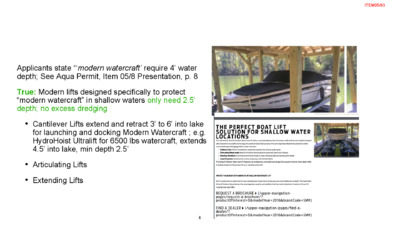
Applicants state “‘modern watercraft’ require 4’ water depth; See Aqua Permit, Item 05/8 Presentation, p. 8 True: Modern lifts designed specifically to protect “modern watercraft” in shallow waters only need 2.5’ depth; no excess dredging • Cantilever Lifts extend and retract 3’ to 6’ into lake for launching and docking Modern Watercraft ; e.g. HydroHoist Ultralift for 6500 lbs watercraft, extends 4.5’ into lake, min depth 2.5’ • Articulating Lifts • Extending Lifts 6 ITEM05/63 7 ITEM05/64 Cantilever Lifts prevalent on Lake Austin HydroHoist Ultra Cantilever Lift; 6500 lbs watercraft, travels 54”, 2.5’ depth Only 8.17 Cu Yds Dredge Volume Less than 25 Cu Yds No dredging needed past ~17.5’ from shoreline Methodology: 2.5’ Depth (Red Line at 490.3’ ) applied to Applicant Data; Intersects “Existing Profile of Lake Bed” at 17.5’ shoreline L, eliminating dredging from 17.5’ to 30’ Using above data for Average End Area Calculation, Dredge Volume = (Ave Height 0.9’ x 14’W x 17.5’ L ) = 220.5 Cu Ft = 8.17 Cu Yds 2.5 requires only 8.17 Cu. Yds of dredge across 17.5’ from shoreline 8 ITEM05/65 Cantilever Lifts prevalent on Lake Austin HydroHoist Ultra Cantilever Lift; 6500 lbs watercraft, travels 54”, 2.5’ depth Only 9.72 Cu Yds Dredge Volume Less than 25 Cu Yds No dredging needed past ~17.5’ from shoreline Methodology: 2.5’ Depth (Red Line at 490.3’) applied to Applicant Data; Intersects “Existing Profile of Lake Bed” at 15’ shoreline L, eliminating dredging from 15’ to 30’ Using above data for Average End Area Calculation, Dredge Volume = (Ave Height, Bulkhead & 15’) 1.25’ x 14’W x 15’ L = 9.72 Cu Yds 2.5’ Depth requires only 9.72 Cu. Yds of dredge across 15.0’ from shoreline 9 ITEM05/66 NO HARDSHIP (1750) Applicants Apply False/Misleading Data FALSE TRUE ‘Modern Watercraft’ require water depth of 4 ft” Forces excessive dredging greater than 25 Cu Yds Dredge Volume: 31.01 Cu Yds Modern lifts specifically designed to store, launch and dock 6500 lbs modern watercraft in shallow waters; 2.5’ depths ; Cradle travels 4.5’ Cantilever Lift Significantly Reduce Dredging Dredge Volume: 8.17 Cu Yds Average End Area Calculation using Applicants’ Data at 2.5’ Depth 10 ITEM05/67 NO HARDSHIP (1752) Applicants Apply False/Misleading Data FALSE TRUE ‘Modern Watercraft’ require water depth of 4 ft” Forces excessive dredging greater than 25 Cu Yds Dredge Volume: 42.18 Cu Yds Modern lifts specifically designed to store, launch and dock 6500 lbs modern watercraft in shallow waters; 2.5’ depths ; Cradle travels 4.5’ Cantilever Lift Significantly Reduce Dredging Dredge Volume: 9.72 Cu Yds Average End Area Calculation using Applicants’ Data at 2.5’ Depth 11 ITEM05/68 • LDC 25-2-1176(A)(1): "A dock may extend up to 30 feet from the shoreline, except that the director may require a dock to extend a lesser or greater distance from the shoreline if deemed necessary to ensure navigation safety" • Navigation safety under LDC 25-2-1176(A)(1) includes navigation safety for the public, watercraft operators, and other legal users of “a navigable waterway” • Applicants blatantly ignore “Navigation safety” for the Public and Lawful Users in the most Congested area of a designated public Navigable Waterway • Applicants’ nonconforming structure egregiously disrupts the safest lane of travel in the most congested and highest traffic area of a designated “navigable waterway;” see e.g. SB 1844 • City of Austin’s Lake Austin Incident Data shows highest responder encounters within 1/2 mile of 360 Bridge Public Watercraft Ramp, including near Applicants’ proposed structures • We urge the Board to seek Legal advice in interpreting “NAVIGATION SAFETY” as codified in LDC 25-2-1176(A)(1) 12 ITEM05/69 13 ITEM05/70 • Airplanes taking off and landing • New to Watercraft operators • Kids on floats • Jet Skis (rental) • New surfers and skiers falling • Multiple watercraft accelerating from Party cove and Boat ramp at no wake buoys near Applicants’ properties 14 ITEM05/71 Nonconforming 1750 & 1752 Docks Are Navigation Hazards to All Proximate Users • “Navigation Safety” applies to all lake users; not just Applicant • Most Watercraft accelerate from idle to high speeds starting at No Wake Zone buoys • Nonconforming Extending 6’ and 16’ into Lake’s most congested and highest usage thoroughfare • Creates an artificial blind curve in a critical area • Disrupts and impedes visibility for all Watercraft, jet skiers, and public users following shoreline and adhering to Lake Laws • Unnecessary Navigational and Safety Hazard for • Watercraft, jet skiers, and public users near 360 Ramp • Many Watercraft exiting “Party Cove,” numerous DUI • Blocks watercraft visibility in congested area, reducing reaction time for watercraft operators • Blocks visibility and reduces reaction time for downstream neighbors entering or exiting their conforming docks 15 ITEM05/72 Nonconforming 1750 & 1752 Docks Are Navigation Hazards for Conforming Neighbors • Applicants’ False statement: “Additionally, this dock’s design will not extend further than nor impede access to any of the neighboring docks.” • All newly constructed docks along Channel Rd, including 1704, 1744, 1756 and 1758 Channel Rd., conform with shoreline length requirements of LDC 25-2-1176(A)(1) • Non-Conforming Structures: Disrupts 6’ and 16’1” into navigable waterway. Creates artificial blind curve • Impedes Visibility of watercraft approaching downstream neighbors entering or exiting their docks at slow speeds, leaving minimal reaction opportunities for approaching vessels • Impedes visibility of downstream neighbors entering or exiting their docks at slow speeds, leaving minimal reaction opportunities for docking vessel • Removes 16’1” of visibility for watercraft operations in Lake’s most congested and highest use thoroughfare • Navigational and Safety Hazard for the immediate three conforming downstream dock users ~30’ of shoreline • Penalizes conforming new structures 16 ITEM05/73