ITEM04 C15-2025-0027 ADV PACKET AUG11 — original pdf
Backup
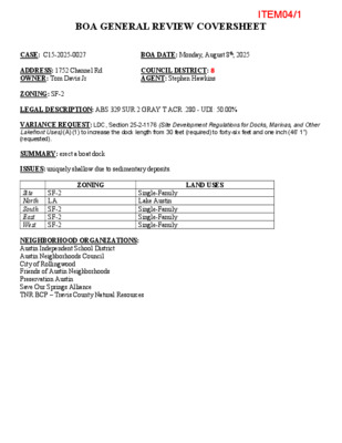
BOA GENERAL REVIEW COVERSHEET CASE: C15-2025-0027 BOA DATE: Monday, August 8th, 2025 ADDRESS: 1752 Channel Rd OWNER: Tom Davis Jr COUNCIL DISTRICT: 8 AGENT: Stephen Hawkins ZONING: SF-2 LEGAL DESCRIPTION: ABS 329 SUR 2 GRAY T ACR .280 - UDI: 50.00% VARIANCE REQUEST: LDC, Section 25-2-1176 (Site Development Regulations for Docks, Marinas, and Other Lakefront Uses) (A) (1) to increase the dock length from 30 feet (required) to forty-six feet and one inch (46’ 1”) (requested). SUMMARY: erect a boat dock ISSUES: uniquely shallow due to sedimentary deposits. ZONING LAND USES SF-2 Site North LA South East West SF-2 SF-2 SF-2 Single-Family Lake Austin Single-Family Single-Family Single-Family NEIGHBORHOOD ORGANIZATIONS: Austin Independent School District Austin Neighborhoods Council City of Rollingwood Friends of Austin Neighborhoods Preservation Austin Save Our Springs Alliance TNR BCP – Travis County Natural Resources ITEM04/1 July 21, 2025 Stephen Hawkins 1752 Channel Rd Austin TX, 78746 Property Description: ABS 329 SUR 2 GRAY T ACR .280 - UDI: 50.00% Re: C15-2025-0027 Dear Stephen, Austin Energy (AE) has reviewed your application for the above referenced property, requesting that the Board of Adjustment consider a variance request from LDC Section 25-2- 1176(A)(1) at 1752 Channel Road. that any proposed or Austin Energy does not oppose existing improvements follow Austin Energy’s Clearance & Safety Criteria, the National Electric Safety Code, and OSHA requirements. Any removal or relocation of existing facilities will be at the owner’s/applicant’s expense. the request, provided Please use this link to be advised of our clearance and safety requirements which are additional conditions of the above review action: https://library.municode.com/tx/austin/codes/utilities_criteria_manual?nodeId=S1AUENDECR_1 .10.0CLSARE If you require further information or have any questions regarding the above comments, please contact our office. Thank you for contacting Austin Energy. Rosemary Avila, Planning Officer Infrastructure Services | Austin Energy 4815 Mueller Blvd Austin, TX 78723 (512) 972-8488 Rosemary.avilla@austinenergy.com ITEM04/2 ITEM04/3 Portion of the City of Austin Land Development Code applicant is seeking a variance from: LDC 25-2-1176(A)(1): "A dock may extend up to 30 feet from the shoreline [into the lake], except ____________________________________________________________________________ that the director may require a dock to extend a lesser or greater distance from the shoreline if ____________________________________________________________________________ deemed necessary to ensure navigation safety" to allow for building a dock 46'1" from the ____________________________________________________________________________ shoreline into the lake. ____________________________________________________________________________ (cid:21)(cid:28)(cid:26)(cid:42)(cid:31)(cid:37)(cid:36) (cid:6)(cid:11) (cid:23)(cid:24)(cid:40)(cid:31)(cid:24)(cid:36)(cid:26)(cid:28) (cid:15)(cid:31)(cid:36)(cid:27)(cid:31)(cid:36)(cid:30)(cid:41) The Board must determine the existence of, sufficiency of, and weight of evidence supporting the findings described below. Therefore, you must complete each of the applicable Findings Statements as part of your application. Failure to do so may result in your application being rejected as incomplete. Please attach any additional supporting documents. NOTE: The Board cannot grant a variance that would provide the applicant with a special privilege not enjoyed by others similarly situated or potentially similarly situated. I contend that my entitlement to the requested variance is based on the following findings: Reasonable Use The zoning regulations applicable to the property do not allow for a reasonable use because: The maximum length from shoreline allowed for a boat dock is a navigational hazard, due to the ____________________________________________________________________________ naturally existing shallow conditions of Lake Austin in this area. Similar neighboring properties ____________________________________________________________________________ have addressed this unique environmental feature for decades by building their boat docks ____________________________________________________________________________ further into the lake. ____________________________________________________________________________ ____________________________________________________________________________ ____________________________________________________________________________ ____________________________________________________________________________ Hardship a) The hardship for which the variance is requested is unique to the property in that: The bathymetry of Lake Austin in this area is uniquely shallow, due to annual sedimentary ____________________________________________________________________________ deposits caused by neighboring property's runoff. ____________________________________________________________________________ ____________________________________________________________________________ ____________________________________________________________________________ ____________________________________________________________________________ b) The hardship is not general to the area in which the property is located because: The homeowners are seeking no special privilege to shoreline use not already given to owners ____________________________________________________________________________ of other similar situated property with approximately contemporaneous development. Due to the ____________________________________________________________________________ nature of the lake's inaccessibility in this area, the extension of a boat dock greater than 30' from ____________________________________________________________________________ shoreline is requested to guarantee the owner's right to access. ____________________________________________________________________________ ____________________________________________________________________________ City of Austin | Board of Adjustment General/Parking Variance Application (cid:21)(cid:18)(cid:28)(cid:18)(cid:21)(cid:21) | Page 5 of 8 ITEM04/4 Area Character The variance will not alter the character of the area adjacent to the property, will not impair the use of adjacent conforming property, and will not impair the purpose of the regulations of the zoning district in which the property is located because: The variance will allow the proposed boat dock to be a functional appurtenence similar to other ____________________________________________________________________________ docks in the area that have been built greater than 30' from shoreline. The proposed dock will ____________________________________________________________________________ adhere to all other Land Development codes pertaining to boat docks. ____________________________________________________________________________ ____________________________________________________________________________ ____________________________________________________________________________ ____________________________________________________________________________ Parking (additional criteria for parking variances only) Request for a parking variance requires the Board to make additional findings. The Board may grant a variance to a regulation prescribed in the City of Austin Land Development Code Chapter 25-6, Appendix A with respect to the number of off-street parking spaces or loading facilities required if it makes findings of fact that the following additional circumstances also apply: 1. Neither present nor anticipated future traffic volumes generated by the use of the site or the uses of sites in the vicinity reasonably require strict or literal interpretation and enforcement of the specific regulation because: ____________________________________________________________________________ ____________________________________________________________________________ ____________________________________________________________________________ ____________________________________________________________________________ 2. The granting of this variance will not result in the parking or loading of vehicles on public streets in such a manner as to interfere with the free flow of traffic of the streets because: ____________________________________________________________________________ ____________________________________________________________________________ ____________________________________________________________________________ ____________________________________________________________________________ 3. The granting of this variance will not create a safety hazard or any other condition inconsistent with the objectives of this Ordinance because: ____________________________________________________________________________ ____________________________________________________________________________ ____________________________________________________________________________ ____________________________________________________________________________ 4. The variance will run with the use or uses to which it pertains and shall not run with the site because: ____________________________________________________________________________ ____________________________________________________________________________ ____________________________________________________________________________ ____________________________________________________________________________ City of Austin | Board of Adjustment General/Parking Variance Application (cid:21)(cid:18)(cid:28)(cid:18)(cid:21)(cid:21) | Page 6 of 8 ITEM04/5 ITEM04/6 TREE SURVEY OF A PORTION OF A CALLED 0.28 ACRES TRACT, VOLUME 3331, PAGE 2285 DEED RECORDS, TRAVIS COUNTY, TEXAS AND A PORTION OF A CALLED 0.14 ACRE AND 0.035 ACRE TRACT VOLUME 12828, PAGE 1851 REAL PROPERTY RECORDS, TRAVIS COUNTY, TEXAS 0 20 40 LEGEND IRON PIPE FOUND (TYPE NOTED) CALCULATED POINT 1/2" IRON ROD FOUND (UNLESS NOTED) APPROXIMATE PROPERTY LINE ADJOINER LINE FLOOD HAZARD LINE CONCRETE AREA D.R.T.C. DOC. NO. O.P.R.T.C. R.P.R.T.C. VOL. PG. ( ) DEED RECORDS TRAVIS COUNTY DOCUMENT NUMBER OFFICIAL PUBLIC RECORDS TRAVIS COUNTY REAL PROPERTY RECORDS TRAVIS COUNTY VOLUME AND PAGE RECORD INFORMATION DOCK L A K E A U S TIN RETAINING WALL DOCK (S 5 7°1 7' E) (5 0.2 3') Z O N E A E Z O (S H N A E X D (S 5 2°1 7' E) (5 0.2 3') 3582 3581 3580 E D ) 3578 3579 oo o o 6' 9.7 1 1/2" TRACT 2 CALLED 0.14 ACRES VOL. 12828, PG. 1851 R.P.R.T.C. SCALE: 1" = 20' (TRACT 1) CALLED 0.249 ACRES DOC. No. 2014113637 O.P.R.T.C. Z O N E A E Z O (S H N A E X D E D ) 3500 3586 3' 8') 9.4 9.6 0" E 9 4' E) (9 7'3 0°1 8°1 (N 3 N 2 1.5" IRON PIPE FOUND RETAINING WALL 3585 ( S 4 1 ° 5 0' E ) ( 5 3 . 7 5') 3584 3583 1/2" IRON ROD FOUND WITH ORANGE CAP STAMPED "WATSON SURVEYING" CALLED 0.28 ACRES VOL. 3331, PG. 2285 D.R.T.C. 3501 3502 N 1 ( N 5 ° 1 2 6 0 ° ' 1 1 4 ' 0 W ) " W ( 6 6 4 . 6 7 . 6 6 ' ) 3 ' (TRACT 2) CALLED 0.415 ACRE DOC. No. 2014113637 O.P.R.T.C. 1') 7.4 2 1') 7.4 2 3" E) (1 3" E) (1 2°1 2°1 (N 3 (N 3 60D NAIL FOUND CALLED 0.423 ACRES DOC. NO. 2004169676 O.P.R.T.C. (S 32°13' W) (122.60') TREE LEGEND CRITICAL ROOT ZONE = DIAMETER EQUAL IN FEET TO TWICE THE NUMBER OF INCHES OF THE TREE'S TRUNK DIAMETER (P) (H) (M) PROTECTED TREE (DIAMETER > 19") HERITAGE TREE (DIAMETER > 24") MULTIPLE TRUNK TREE TABLE Tag No. 3500 3501 3502 3578 3579 3580 3581 3582 3583 3584 3585 3586 Type SYCAMORE CATALPA SYCAMORE CATALPA SYCAMORE SYCAMORE SYCAMORE PECAN CYPRESS CYPRESS CYPRESS Trunk 25 " (P) 32 " (P) 19 1/2 " (P) 14 1/2 " 7 1/2 " 24 1/2 " (P) 18 " 18 1/2 " 42 1/2 " (H) 28 1/2 " (H) 53 " (H) LIGUSTRUM 16 1/2 " (M) 9 " X 8 1/2 " X 6 1/2 " SURVEYED FOR: DAVIS PROJECT NO. 25-0040 1750 & 1752 CHANNEL ROAD AUSTIN, TX (N 31°53'53" E) (30.25') (S 58°06'07" E) (49.65') (N 57°47' W) (50.0') TRACT 1 CALLED 0.035 ACRES VOL. 12828, PG. 1851 R.P.R.T.C. (N 57°48'50" W) (49.42') (S 32°20'10" W) (30.50') 1/2" IRON PIPE FOUND (N 5 7°4 4' W) (5 0.0') GENERAL NOTES: 1) THIS PROPERTY IS SUBJECT TO ANY AND ALL RECORDED AND UNRECORDED EASEMENTS. SURVEYOR HAS MADE NO INVESTIGATION FOR EASEMENTS OF RECORD, ENCUMBRANCES, RESTRICTIVE COVENANTS OR OWNERSHIP TITLE EVIDENCE. 2) SUBJECT TO ALL APPLICABLE DEVELOPMENT CODES AND ZONING ORDINANCES. 3) ALL IMPROVEMENTS NOT SHOWN HEREON. 4) ANY UTILITIES SHOWN HEREON MAY BE EXAGGERATED FOR GRAPHIC REPRESENTATION ONLY. 5) TREE TYPES TO BE VERIFIED BY CERTIFIED ARBORIST. 6) THIS SURVEY ONLY SHOWS ABOVE GROUND IMPROVEMENTS. 7) THIS IS NOT A BOUNDARY SURVEY. I CERTIFY THAT THIS SURVEY HAS BEEN COMPLETED IN ACCORDANCE WITH THE CURRENT REQUIREMENTS OF THE STANDARDS OF PRACTICE FOR SURVEYING IN THE STATE OF TEXAS TO THE BEST OF MY KNOWLEDGE AND BELIEF. CALLED 0.28 ACRES VOL. 3331, PG. 2285 D.R.T.C. DATE OF LAST FIELD WORK: 03/04/2025 ___________________________________________________ JAD DUPLECHAIN, R.P.L.S. NO. 6906 MARCH 12, 2025 REVIEWED BY:JAD DRAWN BY:BB FIELD CREW:JZ REVISION #: SHEET SIZE = 11"X17" FLOOD INFORMATION PER WWW.FEMA.GOV, THIS PROPERTY APPEARS TO BE LOCATED IN ZONE X (SHADED) AND ZONE AE. THIS PROPERTY WAS FOUND IN MAP NUMBER 48453C0435K, DATED 01/22/2020. DATUM & BEARING BASIS TEXAS STATE PLANE COORDINATE SYSTEM, GRID NORTH, CENTRAL ZONE (4203), NAD 83. ELEVATION DATA NAVD 88, GEOID 18. DISTANCES IN US SURVEY FEET (GRID). INFO@SURVEYWORKS.COM SURVEYWORKS.COM 1207 UPLAND DRIVE AUSTIN, TX 78741 FIRM #10194157 (512) 599-8067 SHEET 1 of 1 ITEM04/7 for driveway construction: the owner is responsible for all costs for relocation of, for construction within the right-of-way, a concrete permit is required. for the building permit, a signed and sealed letter shall be submitted to the city of Austin, 6. or damage to utilities. 7. 8. per the land development code, 25-12-3 1612.4, certifying that the structure is in accordance with asce 24, flood resistant design and construction. 9. materials or equipment will be delivered to the site from the landward side of this project. 10. approval of this site plan does not include building and fire code approval nor building permit approval. all work will occur within the limits of construction as shown on the plan, and that no General Notes: 1. This project is not located over the Edwards Aquifer recharge zone. 2. Deed restrictions or restrictive covenants are not applicable to this property. 3. A business or living quarter may not be constructed on a pier or similar structure extending into or above Lake Austin, except under a license agreement approved by the City Council (Section 25-2-1 176 (H)). 4. Contractor to verity utility locations and ground and flow line elevations before construction. 5. Environmental Inspector has the authority to add/or modify erosion/sedimentation controls on site to keep project in compliance with the City of Austin Rules and Regulations. 6. Approval of these plans by the City of Austin indicates compliance with applicable City regulations only. 7. Approval by other government entities may be required prior to the start of construction. The applicant is responsible for determining what additional approvals may be necessary. 8. All work on this project is to be accomplished via barge. There will be no site access by land, nor will any construction staging or materials storage be located on land. THE OWNER SHALL BE RESPONSIBLE FOR INSTALLATION OF THE OWNER/DEVELOPER OF THIS SUBDIVISION/LOT SHALL PROVIDE ● AUSTIN ENERGY HAS THE RIGHT TO PRUNE AND/OR REMOVE TREES, SHRUBBERY AND OTHER OBSTRUCTIONS TO THE EXTENT NECESSARY TO KEEP THE EASEMENTS CLEAR. AUSTIN ENERGY WILL PERFORM ALL TREE WORK IN COMPLIANCE WITH CHAPTER 25-8, SUBCHAPTER B OF THE CITY OF AUSTIN LAND DEVELOPMENT CODE. ● AUSTIN ENERGY WITH ANY EASEMENT AND/OR ACCESS REQUIRED, IN ADDITION TO THOSE INDICATED, FOR THE INSTALLATION AND ONGOING MAINTENANCE OF OVERHEAD AND UNDERGROUND ELECTRIC FACILITIES. THESE EASEMENTS AND/OR ACCESS ARE REQUIRED TO PROVIDE ELECTRIC SERVICE TO THE BUILDING AND WILL NOT BE LOCATED SO AS TO CAUSE THE SITE TO BE OUT OF COMPLIANCE WITH CHAPTER 25-8 OF THE CITY OF AUSTIN LAND DEVELOPMENT CODE. ● TEMPORARY EROSION CONTROL, REVEGETATION AND TREE PROTECTION. IN ADDITION, THE OWNER SHALL BE RESPONSIBLE FOR ANY INITIAL TREE PRUNING AND TREE REMOVAL THAT IS WITHIN TEN FEET OF THE CENTER LINE OF THE PROPOSED OVERHEAD ELECTRICAL FACILITIES DESIGNED TO PROVIDE ELECTRIC SERVICE TO THIS PROJECT. THE OWNER SHALL INCLUDE AUSTIN ENERGY'S WORK WITHIN THE LIMITS OF CONSTRUCTION FOR THIS PROJECT. ● REQUIRED BY THE NATIONAL ELECTRICAL SAFETY CODE, NATIONAL ELECTRICAL CODE, OSHA REGULATIONS, CITY OF AUSTIN RULES AND REGULATIONS AND TEXAS STATE LAWS PERTAINING TO CLEARANCES WHEN WORKING IN CLOSE PROXIMITY TO OVERHEAD POWER LINES AND EQUIPMENT. AUSTIN ENERGY WILL NOT RENDER ELECTRIC SERVICE UNLESS REQUIRED CLEARANCES ARE MAINTAINED. ALL COSTS INCURRED BY AE AS A RESULT OF AN OWNER’S FAILURE TO MAINTAIN REQUIRED CLEARANCES WILL BE CHARGED TO AND SHALL BE THE RESPONSIBILITY OF THE PROPERTY OWNER. ● LANDOWNER'S/DEVELOPER’S EXPENSE. THE PROPERTY OWNER IS RESPONSIBLE FOR MAINTAINING CLEARANCES ANY RELOCATION OF ELECTRIC FACILITIES SHALL BE AT NOTE: PORTIONS OF THIS PROJECT ARE LOCATED IN THE FEMA 100 YEAR FLOODPLAIN AS DEFINED FLOOD INSURANCE MAY BE REQUIRED. THE FEDERAL REGULATIONS FOR DEVELOPMENT IN A FLOODPLAIN CAN BE FOUND IN CHAPTER 44 OF THE CODE OF FEDERAL REGULATIONS (44 CFR). SHEET INDEX: 1 COVER SHEET 2 PLAT 3 PROPOSED SITE PLAN 4 PLAN VIEW (1752 CHANNEL) 5 ELEVATIONS (1752 CHANNEL) 6 PLAN VIEW (1750 CHANNEL) 7 ELEVATIONS (1750 CHANNEL) 8 LANDSCAPE PLAN SITE SPECIFIC NOTES: 1752 CHANNEL ROAD DAVIS TOM MARTIN III OWNER: OWNER MAILING ADDRESS: 1752 CHANNEL RD AUSTIN TX 78746 PROPERTY ADDRESS: 1752 CHANNEL RD AUSTIN TX 78746 LEGAL DESCRIPTION: ABS 329 SUR 2 GRAY T ACR .280 DOCK CONTRACTOR: WATERSHED: WATERSHED CLASSIFICATION: WATER SUPPLY RURAL USE: ACCESSORY USE TO A SINGLE FAMILY RESIDENCE LAKE AUSTIN TBA LA RELATED PERMIT NUMBERS: NONE ZONING: SMART GROWTH ZONE: FLOOD PLAIN INFORMATION: The project is within the 100-yr flood plain as shown on F.E.M.A Firm number 48453C0435K, EFFECTIVE ON 1/22/2020 DRINKING WATER QUALITY ZONE EXISTING SHORELINE LENGTH: ALLOWABLE DOCK WIDTH: PROPOSED DOCK WIDTH: PROPOSED DOCK LENGTH: PROPOSED DOCK FOOTPRINT: 108'8" 21' 9" 21' 9" 30' 652 SQUARE FEET SITE SPECIFIC NOTES: 1750 CHANNEL ROAD RED BUD PARTNERS LP OWNER: OWNER MAILING ADDRESS: 626 SHADYWOOD RD HOUSTON TX 77057 PROPERTY ADDRESS: 1750 CHANNEL RD AUSTIN TX 78746 LEGAL DESCRIPTION: CHANNEL ROAD SUBD BLK A LOT 1 DOCK CONTRACTOR: WATERSHED: WATERSHED CLASSIFICATION: WATER SUPPLY RURAL USE: ACCESSORY USE TO A SINGLE FAMILY RESIDENCE LAKE AUSTIN TBA LA RELATED PERMIT NUMBERS: NONE ZONING: SMART GROWTH ZONE: FLOOD PLAIN INFORMATION: The project is within the 100-yr flood plain as shown on F.E.M.A Firm number 48453C0435K, EFFECTIVE ON 1/22/2020 DRINKING WATER QUALITY ZONE EXISTING SHORELINE LENGTH: ALLOWABLE DOCK WIDTH: PROPOSED DOCK WIDTH: PROPOSED DOCK LENGTH: PROPOSED DOCK FOOTPRINT: 14' 14' 30' 420 SQUARE FEET 52' 10" Development Information: AQUA PERMITS LLC Owner: STEPHEN HAWKINS Address: 6504 BETTY COOK DRIVE, AUSTIN TX 78723 Owner’s representative responsible for plan alternate: Stephen Hawkins Person or firm responsible for erosion/sedimentation control maintenance: TBD Person or firm responsible for tree/natural area protection maintenance: TBD SUBMITTAL DATE: 5/21/2025 APPENDIX P-1 - EROSION CONTROL NOTES 1. The contractor shall install erosion/sedimentation controls, tree/natural area protective fencing, and conduct "Pre-Construction" tree fertilization (if applicable) prior to any site preparation work (clearing, grubbing or excavation). 2. The placement of erosion/sedimentation controls shall be in accordance with the Environmental Criteria Manual and the approved Erosion and Sedimentation Control Plan. T he COA ESC Plan shall be consulted and used as the basis for a TPDES required SWPPP. If a SWPPP is required, it shall be available for review by the City of Austin Environmental Inspector at all times during construction, including at the Pre-Construction meeting. The checklist below contains the basic elements that shall be reviewed for permit approval by COA EV Plan Reviewers as well as COA EV Inspectors. — Plan sheets submitted to the City of Austin MUST show the following: Direction of flow during grading operations. Location, description, and calculations for off-site flow diversion structures. Areas that will not be disturbed; natural features to be preserved. Delineation of contributing drainage area to each proposed BMP (e.g., silt fence, sediment basin, etc.). Location and type of E&S BMPs for each phase of disturbance. Calculations for BMPs as required. Location and description of temporary stabilization measures. Location of on-site spoils, description of handling and disposal of borrow materials, and description of on-site permanent spoils disposal areas, including size, depth of fill and revegetation procedures. Describe sequence of construction as it pertains to ESC including the following elements: 1. Installation sequence of controls (e.g. perimeter controls, then sediment basins, then temporary stabilization, then permanent, etc.) 2. Project phasing if required (LOC greater than 25 acres) 3. Sequence of grading operations and notation of temporary stabilization measures to be used 4. Schedule for converting temporary basins to permanent WQ controls 5. Schedule for removal of temporary controls 6. Anticipated maintenance schedule for temporary controls — Categorize each BMP under one of the following areas of BMP activity as described below: 3.1 Minimize disturbed area and protect natural features and soil 3.2 Control Stormwater flowing onto and through the project 3.3 Stabilize Soils 3.4 Protect Slopes 3.5 Protect Storm Drain Inlets 3.6 Establish Perimeter Controls and Sediment Barriers 3.7 Retain Sediment On-Site and Control Dewatering Practices 3.8 Establish Stabilized Construction Exits 3.9 Any Additional BMPs — Note the location of each BMP on your site map(s). — For any structural BMPs, you should provide design specifications and details and refer t othem. — For more information, see City of Austin Environmental Criteria Manual 1.4. 3. The Placement of tree/natural area protective fencing shall be in accordance with the City of Austin standard Notes for Tree and Natural Area Protection and the approved Grading/Tree and Natural Area Plan. 4. A pre-construction conference shall be held on-site with the contractor, design Engineer/ permit applicant and Environmental Inspector after installation of the erosion/sedimentation controls, tree/natural area protection measures and "Pre-Construction" tree fertilization (if applicable) prior to beginning any site preparation work. The owner or owner's representative shall notify the Development Services Department, 512-974-2278 or by email at environmental.inspections@austintexas. gov, at least three days prior to the meeting date. COA approved ESC Plan and TPDES SWPPP (if required) should be reviewed by COA EV Inspector at this time. 5. Any major variation in materials or locations of controls or fences from those shown on the approved plans will require a revision and must be approved by the reviewing Engineer, Environmental Specialist or City Arborist as appropriate. Major revisions must be approved by authorized COA staff. Minor changes to be made as field revisions to the Erosion and Sedimentation Control Plan may be required by the Environmental Inspector during the course of construction to correct control inadequacies. 6. The contractor is required to provide a certified inspector that is either a licensed engineer (or person directly supervised by the licensed engineer) or Certified Professional in Erosion and Sediment Control (CPESC or CPESC - IT), Certified Erosion, Sediment and Stormwater - Inspector (CESSWI or CESSWI - IT) or Certified Inspector of Sedimentation and Erosion Controls (CISEC or CISEC - IT) certification to inspect the controls and fences at weekly or bi-weekly intervals and after one-half (1⁄2) inch or greater rainfall events to insure that they are functioning properly. The person(s) responsible for maintenance of controls and fences shall immediately make any necessary repairs to damaged areas. Silt accumulation at controls must be removed when the depth reaches six (6) inches or one-third (1⁄3) of the installed height of the control whichever is less. 7. Prior to final acceptance by the City, haul roads and waterway crossings constructed for temporary contractor access must be removed, accumulated sediment removed from the waterway and the area restored to the original grade and revegetated. All land clearing debris shall be disposed of in approved spoil disposal sites. 8. All work must stop if a void in the rock substrate is discovered which is; one square foot in total area; blows air from within the substrate and/or consistently receives water during any rain event. At this time it is the responsibility of the Project Manager to immediately contact a City of Austin Environmental Inspector for further investigation. In addition, if the project site is located within the Edwards Aquifer, the Project Manager must notify the Travis County Balcones Canyonlands Conservation Preserve (BCCP) by email at bccp@traviscountytx.gov. Construction activities within 50 feet of the void must stop. 9. Temporary and Permanent Erosion Control: All disturbed areas shall be restored as noted below: A. All disturbed areas to be revegetated are required to place a minimum of six (6) inches of topsoil [see Standard Specification Item No. 601S.3(A)]. Do not add topsoil within the critical root zone of existing trees. • Topsoil salvaged from the existing site is encouraged for use, but it should meet the standards set forth in 601S. An owner/engineer may propose use of onsite salvaged topsoil which does not meet the criteria of Standard Specification 601S by providing a soil analysis and a written statement from a qualified professional in soils, landscape architecture, or agronomy indicating the onsite topsoil will provide an equivalent growth media and specifying what, if any, soil amendments are required. • Soil amendments shall be worked into the existing onsite topsoil with a disc or tiller to create a well-blended material. The vegetative stabilization of areas disturbed by construction shall be as follows: : TEMPORARY VEGETATIVE STABILIZATION: 1. From September 15 to March 1, seeding shall be with or include a cool season cover crop: (Western Wheatgrass ( Pascopyrum smithii ) at 5.6 pounds per acre, Oats ( Avena sativa ) at 4.0 pounds per acre, Cereal Rye Grain ( Secale cereale ) at 45 pounds per acre. Contractor must ensure that any seed application requiring a cool season cover crop does not utilize annual ryegrass ( Lolium multiflorum ) or perennial ryegra ss ( Lolium perenne ). Cool season cover crops are not permanent erosion control. 2. From March 2 to September 14, seeding shall be with hulled Bermuda at a rate of 45 pounds per acre or a native plant seed mix conforming to Item 604S or 609S. A. Fertilizer shall be applied only if warranted by a soil test and shall conform to Item No. 606S, Fertilizer. Fertilization should not occur when rainfall is expected or during slow plant growth or dormancy. Chemical fertilizer may not be applied in the Critical Water Quality Zone. B. Hydromulch shall comply with Table 1, below. C. Temporary erosion control shall be acceptable when the grass has grown at least 11⁄2 inches high with a minimum of 95% total coverage so that all areas of a site that rely on vegetation for temporary stabilization are uniformly vegetated, and provided there are no bare spots larger than 10 square feet. D. When required, native plant seeding shall comply with requirements of the City of Austin Environmental Criteria Manual, and Standard Specification 604S or 609S Table 1: Hydromulching for Temporary Vegetative Stabilization Material Description Longevity Typical Applications Application Rates 0—3 months Moderate slopes; from flat to 3:1 1,500 to 2,000 lbs per acre 70% or greater Wood/Straw 30% or less Paper or Natural Fibers 100% or any blend of wood, cellulose, straw, and/or cotton plant material (except no mulch shall exceed 30% paper) PERMANENT VEGETATIVE STABILIZATION: 1. From September 15 to March 1, seeding is considered to be temporary stabilization only. If cool season cover crops exist where permanent vegetative stabilization is desired, the grasses shall be mowed to a height of less than one-half (1⁄2) inch and the area shall be re-seeded in accordance with Table 2 below. Alternatively, the cool season cover crop can be mixed with Bermuda grass or native seed and installed together, understanding that germination of warm- season seed typically requires soil temperatures of 60 to 70 degrees. 2. From March 2 to September 14, seeding shall be with hulled Bermuda at a rate of 45 pounds per acre with a purity of 95% and a minimum pure live seed (PLS) of 0.83. Bermuda grass is a warm season grass and is considered permanent erosion control. Permanent vegetative stabilization can also be accomplished with a native plant seed mix conforming to Item 604S or 609S. A. Fertilizer use shall follow the recommendation of a soil test. See Item 606S, Fertilizer. Applications of fertilizer (and pesticide) on City-owned and managed property requires the yearly submittal of a Pesticide and Fertilizer Application Record, along with a current copy of the applicator's license. For current copy of the record template contact the City of Austin's IPM Coordinator. B. Hydromulch shall comply with Table 2, below. C. Water the seeded areas immediately after installation to achieve germination and a healthy stand of plants that can ultimately survive without supplemental water. Apply the water uniformly to the planted areas without causing displacement or erosion of the materials or soil. Maintain the seedbed in a moist condition favorable for plant growth. All watering shall comply with City Code Chapter 6-4 (Water Conservation), at rates and frequencies determined by a licensed irrigator or other qualified professional, and as allowed by the Austin Water Utility and current water restrictions and water conservation initiatives. D. Permanent erosion control shall be acceptable when the grass has grown at least 11⁄2 inches high with a minimum of 95 percent for the non-native mix, and 95 percent coverage for the native mix so that all areas of a site that rely on vegetation for stability must be uniformly vegetated, and provided there are no bare spots larger than 10 square feet. E. When required, native plant seeding shall comply with requirements of the City of Austin Environmental Criteria Manual, Items 604S and 609S. Table 2: Hydromulching for Permanent Vegetative Stabilization Material Description Longevity Typical Applications Application Rates Bonded Fiber Matrix (BFM) 80% Organic defibrated fibers 10% Tackifier 6 months Fiber Reinforced Matrix (FRM) 65% Organic defibrated fibers 25% Reinforcing Fibers or less 10% Tackifier On slopes up to 2:1 and erosive soil conditions 2,500 to 4,000 lbs per acre (see manufacturers recommendations) Up to 12 months On slopes up to 1:1 and erosive Soil conditions 3,000 to 4,500 lbs per acre (see manufacturers recommendations) 10. The contractor shall not dispose of surplus excavated material from the site without notifying the Development Services Department at 512-974-2278 at least 48 hours prior with the location and a copy of the permit issued to receive the material. REVISIONS / CORRECTIONS Number Description Revise (R) Add (A) Void (V) Sheet No.'s Total # of Sheets in Plan Set Net Change Imp. Cover (Sq-Ft) Date Imaged City of Austin Approval Date C. Where trees are close to proposed buildings, erect the fence to allow 6 to 10 feet of work space between the fence and the building; D. Where there are severe space constraints due to tract size, or other special requirements, contact the City Arborist at 974-1876 to discuss alternatives. Special Note: For the protection of natural areas, no exceptions to installing fences at the Limit of Construction line will be permitted. 7. Where any of the above exceptions result in a fence being closer than 4 feet to a tree trunk, protect the trunk with strapped-on planking to a height of 8 ft (or to the limits of lower branching) in addition to the reduced fencing provided. 8. Trees approved for removal shall be removed in a manner which does not impact trees to be preserved. 9. Any roots exposed by construction activity shall be pruned flush with the soil. Backfill root areas with good quality top soil as soon as possible. If exposed root areas are not backfilled within 2 days, cover them with organic material in a manner which reduces soil temperature and minimizes water loss due to evaporation. 10. Any trenching required for the installation of landscape irrigation shall be placed as far from existing tree trunks as possible. 11. No landscape topsoil dressing greater than 4 inches shall be permitted within the drip line of trees. No soil is permitted on the root flare of any tree. 12. Pruning to provide clearance for structures, vehicular traffic and equipment shall take place before damage occurs (ripping of branches, etc.). 13. All finished pruning shall be done according to recognized, approved standards of the industry (Reference the National Arborist Association Pruning Standards for Shade Trees available on request from the City Arborist). 14. Deviations from the above notes may be considered ordinance violations if there is substantial non-compliance or if a tree sustains damage as a result. APPENDIX P-4: - STANDARD SEQUENCE OF CONSTRUCTION The following sequence of construction shall be used for all development. The applicant is encouraged to provide any additional details appropriate for the particular development. 1. Temporary erosion and sedimentation controls are to be installed as indicated on the approved site plan or subdivision construction plan and in accordance with the Erosion Sedimentation Control Plan (ESC) and Stormwater Pollution Prevention Plan (SWPPP) that is required to be posted on the site. Install tree protection, initiate tree mitigation measures and conduct "Pre - Construction" tree fertilization (if applicable). 2. The Environmental Project Manager or Site Supervisor must contact the Development Services Department, Environmental Inspection, at 512-974-2278, 72 hours prior to the scheduled date of the required on-site preconstruction meeting. 3. The Environmental Project Manager, and/or Site Supervisor, and/or Designated Responsible Party, and the General Contractor will follow the Erosion Sedimentation Control Plan (ESC) and Storm Water Pollution Prevention Plan (SWPPP) posted on the site. Temporary erosion and sedimentation controls will be revised, if needed, to comply with City Inspectors' directives, and revised construction schedule relative to the water quality plan requirements and the erosion plan. 4. Rough grade the pond(s) at 100% proposed capacity. Either the permanent outlet structure or a temporary outlet must be constructed prior to development of embankment or excavation that leads to ponding conditions. The outlet system must consist of a sump pit outlet and an emergency spillway meeting the requirements of the Drainage Criteria Manual and/or the Environmental Criteria Manual, as required. The outlet system shall be protected from erosion and shall be maintained throughout the course of construction until installation of the permanent water quality pond(s). 5. Temporary erosion and sedimentation controls will be inspected and maintained in accordance with the Erosion Sedimentation Control Plan (ESC) and Storm Water Pollution Prevention Plan (SWPPP) posted on the site. 6. Begin site clearing/construction (or demolition) activities. 7. In the Barton Springs Zone, the Environmental Project Manager or Site Supervisor will schedule a mid-construction conference to coordinate changes in the construction schedule and evaluate effectiveness of the erosion control plan after possible construction alterations to the site. Participants shall include the City Inspector, Project Engineer, General Contractor and Environmental Project Manager or Site Supervisor. The anticipated completion date and final construction sequence and inspection schedule will be coordinated with the appropriate City Inspector. 8. Permanent water quality ponds or controls will be cleaned out and filter media will be installed prior to/concurrently with revegetation of site. 9. Complete construction and start revegetation of the site and installation of landscaping. 10. Upon completion of the site construction and revegetation of a project site, the design engineer shall submit an engineer's letter of concurrence bearing the engineer's seal, signature, and date to the Development Services Department indicating that construction, including revegetation, is complete and in substantial compliance with the approved plans. After receiving this letter, a final inspection will be scheduled by the appropriate City inspector. 11. Upon completion of landscape installation of a project site, the Landscape Architect shall submit a letter of concurrence to the Development Services Department indicating that the required landscaping is complete and in substantial conformity with the approved plans. After receiving this letter, a final inspection will be scheduled by the appropriate City inspector. 12. After a final inspection has been conducted by the City inspector and with approval from the City inspector, remove the temporary erosion and sedimentation controls and complete any necessary final revegetation resulting from removal of the controls. Conduct any maintenance and rehabilitation of the water quality ponds or controls. 3.6.2 STANDARD PLAN NOTE THE FOLLOWING PLAN NOTE SUMMARIZES THE CONTENTS OF THE ENVIRONMENTAL CRITERIA MANUAL AS IT RELATES TO TREE PROTECTION ON SITES WITH ACTIVE PERMITS: BEFORE CONSTRUCTION ALL TREES AND NATURAL AREAS SHOWN ON PLAN TO BE PRESERVED SHALL BE PROTECTED PER ECM 3.6.1. TREE PROTECTION SHALL BE INSTALLED PRIOR TO THE START OF ANY SITE WORK, INCLUDING DEMOLITION OR SITE PREPARATION. REFER TO ECM 3.6.1.A. FENCING FOR TREE PROTECTION SHALL BE CHAIN-LINK MESH WITH A MINIMUM HEIGHT OF 5 FEET AND SHALL BE INSTALLED AROUND OR BEYOND THE CRITICAL ROOT ZONE EXCEPT AS ALLOWED IN ECM 3.6.1.B.4. UNFENCED SECTIONS OF THE CRITICAL ROOT ZONE SHALL BE COVERED WITH MULCH AT A MINIMUM DEPTH OF 8 INCHES AND A MAXIMUM DEPTH OF 12 INCHES PER ECM 3.6.1.C. WHERE FENCING IS LOCATED 5 FEET OR LESS FROM THE TRUNK OF A PRESERVED TREE, TRUNK WRAPPING SHALL BE INSTALLED PER ECM 3.6.1.D. EROSION AND SEDIMENTATION CONTROLS SHALL BE INSTALLED AND MAINTAINED SO AS NOT TO CAUSE IMPACTS THAT EXCEED PRESERVATION CRITERIA LISTED IN ECM 3.5.3.D. DURING CONSTRUCTION TREES APPROVED FOR REMOVAL SHALL BE REMOVED IN A MANNER THAT DOES NOT EXCEED PRESERVATION CRITERIA FOR THE TREES TO REMAIN. REFER TO ECM 3.5.2 A. FENCING MAY NOT BE TEMPORARILY MOVED OR REMOVED DURING DEVELOPMENT WITHOUT PRIOR AUTHORIZATION. THE FENCED CRITICAL ROOT ZONE SHALL NOT BE USED FOR TOOL OR MATERIAL STORAGE OF ANY KIND AND SHALL BE KEPT FREE OF LITTER. REFER TO ECM 3.6.1.B.3. PRUNING SHALL BE IN COMPLIANCE WITH THE CURRENT ANSI A300 STANDARD FOR TREE CARE. AFTER CONSTRUCTION TREE PROTECTION SHALL BE REMOVED AT THE END OF THE PROJECT AFTER ALL CONSTRUCTION AND FINAL GRADING IS COMPLETE, BUT BEFORE FINAL INSPECTION. REFER TO ECM 3.6.1.A. LANDSCAPE INSTALLATION WITHIN THE CRZ OF PRESERVED TREES, INCLUDING IRRIGATION, SOIL AND PLANTINGS, SHALL NOT EXCEED PRESERVATION CRITERIA LISTED IN ECM 3.5.2. DOCUMENTATION OF TREE WORK PERFORMED MUST BE PROVIDED TO INSPECTOR PER ECM APPENDIX P-6. THIS LIST IS NOT EXHAUSTIVE. REFER TO APPROPRIATE ECM SECTIONS FOR FULL REQUIREMENTS. SOURCE: RULES NO. R161-21.22, 9-15-2021. APPENDIX P-6 - REMEDIAL TREE CARE NOTES AERATION AND SUPPLEMENTAL NUTRIENT REQUIREMENTS FOR TREES WITHIN CONSTRUCTION AREAS As a component of an effective remedial tree care program per Environmental Criteria Manual section 3.5.4, preserved trees within the limits of construction may require soil aeration and supplemental nutrients. Soil and/or foliar analysis should be used to determine the need for supplemental nutrients. The City Arborist may require these analyses as part of a comprehensive tree care plan. Soil pH shall be considered when determining the fertilization composition as soil pH influences the tree's ability to uptake nutrients from the soil. If analyses indicate the need for supplemental nutrients, then humate/nutrient solutions with mycorrh izae components are highly recommended. In addition, soil analysis may be needed to determine if organic material or beneficial microorganisms are needed to improve soil health. Materials and methods are to be approved by the City Arborist (512-974-1876) prior to application. The owner or general contractor shall select a fertilization contractor and ensure coordination with the City Arborist. Pre-construction treatment should be applied in the appropriate season, ideally the season preceding the proposed construction. Minimally, areas to be treated include the entire critical root zone of trees as depicted on the City approved plans. Treatment should include, but not limited to, fertilization, soil treatment, mulching, and proper pruning. Post-construction treatment should occur during final revegetation or as determined by a qualified arborist after construction. Construction activities often result in a reduction in soil macro and micro pores and an increase in soil bulk density. To ameliorate the degraded soil conditions, aeration via water and/or air injected into the soil is needed or by other methods as approved by the City Arborist. The proposed nutrient mix specifications and soil and/or foliar analysis results need to be provided to and approved by the City Arborist prior to application (Fax # 512-974-3010). Construction which will be completed in less than 90 days may use materials at 1⁄2 recommended rates. Alternative organic fertilizer materials are acceptable when approved by the City Arborist. Within 7 days after fertilization is performed, the contractor shall provide documentation of the work performed to the City Arborist, Planning and Development Review Department. P.O. Box 1088, Austin, TX 78767. This note should be referenced as item #1 in the Sequence of Construction. Site Plan Release Notes: The following site plan release notes are included in accordance with the City of Austin’s request. Applicant will comply with all applicable City of Austin requirements. 1. All improvements shall be made in accordance with the released site plan. Any additional improvements will require site plan amendment and approval of the Planning and Development Review Department. 2. All signs must comply with requirements of the Land Development Code. (Section 1 3-2, Article VII) 3. Additional electric easements may be required at a later date. 4. All existing structures shown to be removed will require a demolition permit from the City of Austin Planning and Development Review Department. 5. A development Permit must be issued prior to an application for building permit for non-consolidated or Planning Commission approved site plans. SITE PLAN APPROVAL SHEET____OF____ FILE NUMBER_______________ ___________ APPLICATION DATE__________ APPROVED BY COMMISSION ON ___________ UNDER SECTION ____ OF CHAPTER ______OF THE CITY OF AUSTIN CODE DATE (LDC 25-5-81) ___________ CASE MANAGER____________ PROJECT EXPIRATION DATE (ORD.#970905-A) ________ DWPZ ____ DDZ ____ _________________________________________________ DIRECTOR, DEVELOPMENT SERVICES DEPARTMENT RELEASED FOR GENERAL COMPLIANCE______________ ZONING____________ REVISION 1______________________ CORRECTION 1_____________________ REVISION 2______________________ CORRECTION 2_____________________ REVISION 3______________________ CORRECTION 3_____________________ Engineer signature and seal per City code Section 25-2-1173 Signature and Seal___________________________________ DEVELOPMENT SERVICES SIGNATURE_______________________ Address____________________________________________ NOTE: IF AT ANY TIME DURING C ONSTRUCTION OF THIS PROJECT AN UNDERGROUND STORAGE TANK (UST) IS FOUND, CONSTRUCTION IN THAT AREA MUST STOP UNTIL A CITY OF AUSTIN UST CONSTRUCTION PERMIT IS APPLIED FOR AND APPROVED. ANY UST REMOVAL WORK MUST BE CONDUCTED BY A UST CONTRACTOR THAT IS REGISTERED WITH THE TEXAS COMMISSION ON ENVIRONMENTAL QUALITY (TCEQ). CONTACT UST@AUSTINTEXAS.GOV IF YOU HAVE ANY QUESTIONS. [COA TITLE 6] Final plat must be recorded by the project expiration date, if applicable. Subsequent site plans which do not comply with the Code current at the time of filing, and all required building permits and/or a notice of construction (if a building permit is not required) must also be approved prior to the project expiration date. Phone_____________________________________________ AQUA PERMITS LLC AUSTIN TEXAS DESIGN, PERMITTING, CONSULTING, Y MAS ON THE SHORE OF LAKE AUSTIN IN THE BEAUTIFUL STATE OF TEXAS, UNITED STATES OF AMERICA. PLANS PRODUCED IN CONJUNCTION WITH TEXAS REGISTERED PROFESSIONAL ENGINEERING FIRM: DANIEL P. HAMM F-23857 303 MARLY WAY, AUSTIN TX 78733 (512)-549-0560 D B L E N N A H C G D L B . D R L E N N A H C 6 4 7 8 7 S A X E T , I N T S U A ' S L L E & W 2 5 7 1 0 5 7 1 DATE 11/8/2024 SCALE ENGINEER STAMP: DRAFTER AQUA PERMITS FILE SP-2025-0119D SHEET COVER SHEET 1 OF 8 ITEM04/8 1752 CHANNEL 1752 CHANNEL LAND STATUS LAND STATUS DETERMINATION DETERMINATION 1750 CHANNEL 1750 CHANNEL PLAT PLAT AQUA PERMITS LLC AUSTIN TEXAS DESIGN, PERMITTING, CONSULTING, Y MAS ON THE SHORE OF LAKE AUSTIN IN THE BEAUTIFUL STATE OF TEXAS, UNITED STATES OF AMERICA. PLANS PRODUCED IN CONJUNCTION WITH TEXAS REGISTERED PROFESSIONAL ENGINEERING FIRM: DANIEL P. HAMM F-23857 303 MARLY WAY, AUSTIN TX 78733 (512)-549-0560 D B L E N N A H C G D L B . D R L E N N A H C 6 4 7 8 7 S A X E T , I N T S U A ' S L L E & W 2 5 7 1 0 5 7 1 DATE 11/8/2024 SCALE ENGINEER STAMP: DRAFTER AQUA PERMITS FILE SP-2025-0119D SHEET PLAT 2 OF 8 ITEM04/9 SITE PLAN SITE PLAN LEGEND LOC FTC TP LIMITS OF CONSTRUCTION FLOATING TURBIDITY CURTAIN TREE PROTECTION EXISTING CONCRETE BULKHEAD LAKE AUSTIN SHORELINE 492.8' PROPOSED CONSTRUCTION TREE LIST 1. 54" CYPRESS 2. 29.5" CYPRESS 3. 42.5" CYPRESS 4. 18.5" PECAN 5. 18" SYCAMORE 6. 26" SYCAMORE 7. 21" SYCAMORE 8. 31" PECAN 9. 19" PINE 10. 23.5" SYCAMORE 11. 22.5" CATALPA 12. 25" AM. ELM 13. 15" CATALPA 14. 25.5" (8+7+5+5+4+4+4+4+2.5) CREPE MYRTLE (MULTI) SURVEYED: ● ● ● ● REMOVED ● ● ● ● ● ● ● ● ● MITIGATION: ● ● ● ● ● ● TOTAL APPENDIX F TREE INCHES SURVEYED: 305.5 HERITAGE TREE INCHES SURVEYED: 183 NON-APPENDIX F TREE INCHES SURVEYED; (INCLUDES INVASIVE AND NON-APP F): 0 INVASIVE TREE INCHES SURVEYED: 0 TOTAL APPENDIX F INCHES REMOVED: 0 HERITAGE TREE INCHES REMOVED: 0 TOTAL NON-APPENDIX F INCHES REMOVED; (INCLUDES INVASIVE AND NON-APP F): 0 INVASIVE INCHES REMOVED: 0 TOTAL DEAD, DISEASED, OR IMMINENT HAZARD (DDI) INCHES REMOVED: 0 DDI APPENDIX F INCHES REMOVED: 0 DDI HERITAGE TREE INCHES REMOVED: 0 DDI NON-APPENDIX F INCHES REMOVED: 0 DDI INVASIVE INCHES REMOVED: 0 TOTAL MITIGATION REPLACEMENT INCHES PLANTED: 3 TOTAL REPLACEMENT INCHES PLANTED ON SITE (PRIVATE TREES): 0 TOTAL REPLACEMENT ROW INCHES PLANTED: 0 PRIVATE INCHES OWED TO URBAN FOREST REPLENISHMENT FUND (UFRF): 0 PUBLIC INCHES OWED TO UFRF: 0 TOTAL NON-MITIGATION INCHES PLANTED ON SITE; [ECM 3.5.4]: 0 SITE PLAN NOTES: - ENVIRONMENTAL INSPECTOR HAS THE AUTHORITY TO ADD AND/OR MODIFY EROSION/SEDIMENTATION CONTROLS ON SITE TO KEEP PROJECT IN COMPLIANCE NO WATER OR WASTEWATER UTILITIES ARE PROPOSED WITH THIS DEVELOPMENT. ALL AREAS DISTURBED IN THE CRITICAL WATER QUALITY ZONE SHOULD BE WITH THE CITY OF AUSTIN RULES AND REGULATIONS. [LDC 25-2-183] - - RESTORED AS PER STANDARD SPECIFICATION 609.S. - - - THE PROPOSED BOAT DOCK WILL BE AT LEAST 66% OPEN[LDC 25-2-1176 (A)(8)(B) ALL WORK TO BE PERFORMED FROM BARGE PERMANENT IMPROVEMENTS ARE PROHIBITED WITHIN THE SHORELINE SETBACK AREA [LDC-25-2-551 (8)(3)] THE PROPOSED BOAT DOCK MUST COMPLY WITH ALL REQUIREMENTS OF LDC 25-2-1174 ("STRUCTURAL REQUIREMENTS") AND MUST COMPLY WITH CHAPTER 25-12, ARTICLE 1 (UNIFORM BUILDING CODE) AND THE BUILDING CRITERIA MANUAL - 482 10' PROPERTY LINE SETBACK 484 486 488 490 NATURAL SHORELINE FOLLOWS BALD CYPRESS ROOT SYSTEM 100% CRZ 50% CRZ 25% CRZ 1 N 3 492 0°2 5'3 3"E 9 9.4 1' 7 R O N30°25'33"E 99.41' COA AND FEMA FULLY DEVELOPED FLOODPLAIN LINE 495.0' MSL 494 496 C O N C R E T E C K A N D W 2 25% CRZ 50% CRZ 100% CRZ 3 25% CRZ 50% CRZ 100% CRZ O O D H O U S E TRACT 1 J. W. WASHINGTON 0.2785 ACRE (0.28 ACRE) 1752 CHANNEL ROAD C O N C. W 11 O C S 1 3 ° 1 3 ' 1 4 " E 6 6 . 6 7 ' RETE RIVEWAY C N D A L K 10 9 4 R O P A C K TIO 75' CWQZ SETBACK S32°13'00"W 126.97' S 32°13'00"" W 126.97' 8 S 5 6°5 6'2 4"E 5 0.6 2' C H A N N E L R O A D 14 S 57°55'18" E 49.45' O O E E N N I I N N G G A A U U S S T T I I N N EXISTING 1 STORY BOAT DOCK (TO BE REMOVED) 17'-6" 10' PROPERTY LINE SETBACK 13'-7" 30'-8" TOP OF WALL ELEVATION: 494.6' 33'-2" 492.8' LAKE AUSTIN SHORELINE BOAT SLIP 16'-1" 32'-10" S 5 2°1 7'0 0"E 5 0.2 100% CRZ 3' 16'-2" 50% CRZ 25% CRZ 25% CRZ 6 5 50% CRZ 100% CRZ 100% CRZ 50% CRZ 25% CRZ 12 C O S 5 7°1 7'0 0" E 5 0.2 3' 7'-1" 7'-11" 7'-6" 100% CRZ 50% CRZ 25% CRZ 13 N C R E T E TRACT 4 TOM M. DAVIS 0.145 ACRE (0.14 ACRE) 1750 CHANNEL ROAD S 32°34'06" W 126.34' R O N 30'-2" EXISTING 1 STORY BOAT DOCK (TO BE REMOVED) 494 C O N C R E T E C K A N D W All responsibility for the adequacy of these plans remain with the engineer who prepared them. In approving these plans, the City of Austin must rely on the adequacy of the work of the design engineer. 482 L L A A L L 10' PROPERTY LINE SETBACK A A K K Z Z THE PROPOSED BOAT DOCK MUST COMPLY WITH ALL REQUIREMENTS OF LDC 25-2-1174 (“STRUCTURAL REQUIREMENTS”), AND MUST COMPLY WITH CHAPTER 25-12, ARTICLE 1 (UNIFORM BUILDING CODE) AND THE BUILDING CRITERIA MANUAL. N L L A A L L A A K K Z Z O O E E N N I I N N G G A A U U S S T T I I N N LO C L O C FTC F T C L O C F T C 22' L O C DOCK LIGHTING PER LDC 25-2-1175 F T C L O C F T C L O C F T C L O C 484 486 488 LIMITS OF CONSTRUCTION 490 FLOATING TURBIDITY CURTAIN NEW 789 SQ FT THREE STORY BOAT DOCK TOP OF WALL ELEVATION: 494.6' 492.8' LAKE AUSTIN SHORELINE LO C FT C LO C 30' FT C LO C 46'-1" FTC N 3 492 0°2 5'3 3"E 9 9.4 1' 496 T P T P C LO 16'-1" FTC 2 25% CRZ 50% CRZ 100% CRZ INSTALL TREE PROTECTION FENCING T P L T O P C 3 25% CRZ 50% CRZ 100% CRZ S 5 2°1 T P T P 12'-6" L O C 7'0 0"E 5 T P 4' LOC 4' T P TP TP 0.2 100% CRZ 3' L O C 50% CRZ 25% CRZ 25% CRZ 6 5 50% CRZ 100% CRZ 8" STEEL PILINGS 6 5 DRIVEN TO REFUSAL F T C L O C 5'-6" 3' F T C DOCK LIGHTING PER LDC 25-2-1175 L O C F T C L O C NEW 487 SQ FOOT TWO STORY BOAT DOCK L O C L O C 30' S 5 7°1 7'0 L O C 0" E 5 7'-3" 0.2 3' 14' C T F LO C FT C LO C F T C LO C 30' FTC LO C O O D H O U S E 4 R O P A C K TIO COA AND FEMA FULLY DEVELOPED FLOODPLAIN LINE 495.0' MSL 75' CWQZ SETBACK L O C 100% CRZ 50% CRZ 25% CRZ 12 C O N C R E T E F T C LO C L O C 9'-7" TP TP T P TP 100% CRZ 50% CRZ 25% CRZ 13 8" STEEL PILINGS 6 5 DRIVEN TO REFUSAL EXISTING PLAN 1"=20' (24" X 36" PAPER) BOARDS FENCE LOCATION PRIOR TO CLEARING, GRADING AND PAVING PERMEABLE PAVING AREA CURB FENCE LOCATION DURING PERMEABLE PAVING INSTALLATION TEMPORARY ACCESS ROAD, EXISTING ROADWAY OR EASEMENT AS APPROVED CRZ CRZ BOARDS WOOD CHIP MULCH AREA 100 mm - 150 mm (4"-6") DEPTH LINEAR CONSTRUCTION THROUGH TREES LIMIT OF CONTRUCTION LINE AS SHOWN ON PLAN NATURAL AREAS CRITICAL ROOT ZONE (C.R.Z) RADIUS = 12mm PER mm (1 FT. PER INCH) OF TRUNK DIAMETER TREES IN PAVING AREA MINIMUM NECESSARY WORK AREA (WOOD CHIP MULCH 100 TO 150 mm 4" TO 6" DEPTH) BLDG. ADD BOARDS STRAPPED TO TRUNK DUE TO CLOSENESS OF FENCE LESS THAN 1.5 m (5') FROM TRUNK TREES NEAR CONSTRUCTION ACTIVITY INDIVIDUAL TREE GROUP OF TREES CITY OF AUSTIN WATERSHED PROTECTION DEPARTMENT TREE PROTECTION FENCE LOCATIONS RECORD COPY SIGNED BY J. PATRICK MURPHY 11/16/99 ADOPTED THE ARCHITECT/ENGINEER ASSUMES RESPONSIBILITY FOR APPROPRIATE USE OF THE STANDARD STANDARD NO. 610S-1 FLOATING TURBIDITY CURTAIN Floatation Water Surface Filter Cloth Skirt (Variable Depth) Ballast Chain Channel Bottom S32°13'00"W 126.97' S 32°13'00"" W 126.97' 8 TRACT 4 TOM M. DAVIS 0.145 ACRE (0.14 ACRE) 1750 CHANNEL ROAD INSTALL TREE PROTECTION FENCING 10' PROPERTY LINE SETBACK PROPOSED PLAN 1"=10' (24" X 36" PAPER) S 32°34'06" W 126.34' AQUA PERMITS LLC AUSTIN TEXAS DESIGN, PERMITTING, CONSULTING, Y MAS ON THE SHORE OF LAKE AUSTIN IN THE BEAUTIFUL STATE OF TEXAS, UNITED STATES OF AMERICA. PLANS PRODUCED IN CONJUNCTION WITH TEXAS REGISTERED PROFESSIONAL ENGINEERING FIRM: DANIEL P. HAMM F-23857 303 MARLY WAY, AUSTIN TX 78733 (512)-549-0560 D B L E N N A H C G D L B . D R L E N N A H C 6 4 7 8 7 S A X E T , I N T S U A ' S L L E & W 2 5 7 1 0 5 7 1 DATE 11/8/2024 SCALE VARIES ENGINEER STAMP: DRAFTER AQUA PERMITS FILE SP-2025-0119D SHEET SITE PLAN SHEET 3 OF 8 ITEM04/10 6" 10' 22' 1' 10' 6" 22' 16'-6" 4' 1'-6" 22' 16'-6" 4' 1'-6" *THESE ELEVATIONS AND PLANS ARE FOR SCHEMATIC PURPOSES ONLY AND DO NOT CONSTITUTE A STRUCTURAL DESIGN. FULLY ENGINEERED SHOP DRAWINGS SHOULD BE PROVIDED TO THE EOR PRIOR TO CONSTRUCTION. DOCK LIGHTING PER LDC 25-2-1175 POURED CONCRETE DECKING STAIR ACCESS TO THIRD FLOOR 30' POURED CONCRETE DECKING STAIR ACCESS TO THIRD FLOOR 10' 25'-3" 30' 10' 46'-1" 8'-6" 6" X 6" ROUND STEEL PILINGS DRIVEN TO REFUSAL 4' SLIP USES HYDRAULIC LIFT WITH SUBMERSIBLE DECKING 15'-7" TREX COMPOSITE DECKING OR SIM. 10'-5" 3' 16.5 SQ FOOT STORAGE CLOSET 5'-6" STAIRS LEADING TO SECOND FLOOR OF BOAT DOCK 16'-1" 16'-1" ACCESS RAMP TO FIRST FLOOR OF BOAT DOCK FROM LAND EXISTING CONCRETE BULKHEAD (NO CHANGES PROPOSED) 12'-6" 4' 4' FIRST FLOOR PLAN VIEW SECOND FLOOR PLAN VIEW THIRD FLOOR PLAN VIEW AQUA PERMITS LLC AUSTIN TEXAS DESIGN, PERMITTING, CONSULTING, Y MAS ON THE SHORE OF LAKE AUSTIN IN THE BEAUTIFUL STATE OF TEXAS, UNITED STATES OF AMERICA. PLANS PRODUCED IN CONJUNCTION WITH TEXAS REGISTERED PROFESSIONAL ENGINEERING FIRM: DANIEL P. HAMM F-23857 303 MARLY WAY, AUSTIN TX 78733 (512)-549-0560 D B L E N N A H C G D L B . D R L E N N A H C 6 4 7 8 7 S A X E T , I N T S U A ' S L L E & W 2 5 7 1 0 5 7 1 DATE 11/8/2024 1 4"=1' SCALE ENGINEER STAMP: DRAFTER AQUA PERMITS FILE SP-2025-0119D SHEET PLAN VIEW 1752 CHANNEL 4 OF 8 ITEM04/11 OPEN OPEN OPEN OPEN OPEN OPEN EXISTING CONCRETE BULKHEAD HEIGHT OF HIGHEST STRUCTURAL MEMBER: 518.133' MSL DOCK LIGHTING PER LDC 25-2-1175 16.5 SQUARE FOOT STORAGE CLOSET COA AND FEMA FULLY DEVELOPED FLOODPLAIN LINE: 495.0' MSL HEIGHT OF LOWEST STRUCTURAL MEMBER: 494.8' MSL LAKE AUSTIN ELEVATION: 492.8' MSL 8" ROUND STEEL PILINGS 6 5 DRIVEN TO REFUSAL NATURAL LAKE BED *THESE ELEVATIONS AND PLANS ARE FOR SCHEMATIC PURPOSES ONLY AND DO NOT CONSTITUTE A STRUCTURAL DESIGN. FULLY ENGINEERED SHOP DRAWINGS SHOULD BE PROVIDED TO THE EOR PRIOR TO CONSTRUCTION. 4' 15'-7" 10'-5" 30' 15'-7" 6" 46'-1" 25'-4" 3'-6" 1' 5'-5" 3'-6" 1' 8'-11" 1' 1' OPEN OPEN OPEN OPEN OPEN OPEN VIEW FROM DOWNSTREAM NATURAL LAKE BED VIEW FROM UPSTREAM OPEN OPEN 1'-6" 4' 16'-6" 22' OPEN OPEN 3'-6" 1' 5'-5" 3'-6" 25'-4" 1' OPEN OPEN OPEN OPEN 8'-11" 8' 1' 1' 5'-6" 6" 10' 1' 10' 6" VIEW FROM LAND VIEW FROM WATER AQUA PERMITS LLC AUSTIN TEXAS DESIGN, PERMITTING, CONSULTING, Y MAS ON THE SHORE OF LAKE AUSTIN IN THE BEAUTIFUL STATE OF TEXAS, UNITED STATES OF AMERICA. PLANS PRODUCED IN CONJUNCTION WITH TEXAS REGISTERED PROFESSIONAL ENGINEERING FIRM: DANIEL P. HAMM F-23857 303 MARLY WAY, AUSTIN TX 78733 (512)-549-0560 D B L E N N A H C G D L B . D R L E N N A H C 6 4 7 8 7 S A X E T , I N T S U A ' S L L E & W 2 5 7 1 0 5 7 1 DATE 11/8/2024 1 4"=1' SCALE ENGINEER STAMP: DRAFTER AQUA PERMITS FILE SP-2025-0119D SHEET ELEVATIONS 1752 CHANNEL 5 OF 8 ITEM04/12 LAKE AUSTIN SHORELINE 492.8' MSL 13'-8" 7'-3" 12 SQ FT STORAGE CLOSET 14'-0" STEEL CORRUGATED ROOFING 20'-0" 14'-6" 4'-0" 4'-0" 2'-0" 4'-0" 30'-0" 30'-0" POURED CONCRETE DECKING 7'-0" 7'-0" 24'-0" 14'-6" 2'-6" INSTALL COFFER DAM ALONG PERIMETER OF BOAT SLIP 6 5 8" STEEL PILINGS DRIVEN TO REFUSAL 1'-6" 13'-0" 10'-0" 14'-0" ROOF PLAN VIEW FIRST FLOOR PLAN VIEW SECOND FLOOR PLAN VIEW *THESE ELEVATIONS AND PLANS ARE FOR SCHEMATIC PURPOSES ONLY AND DO NOT CONSTITUTE A STRUCTURAL DESIGN. FULLY ENGINEERED SHOP DRAWINGS SHOULD BE PROVIDED TO THE EOR PRIOR TO CONSTRUCTION. AQUA PERMITS LLC AUSTIN TEXAS DESIGN, PERMITTING, CONSULTING, Y MAS ON THE SHORE OF LAKE AUSTIN IN THE BEAUTIFUL STATE OF TEXAS, UNITED STATES OF AMERICA. PLANS PRODUCED IN CONJUNCTION WITH TEXAS REGISTERED PROFESSIONAL ENGINEERING FIRM: DANIEL P. HAMM F-23857 303 MARLY WAY, AUSTIN TX 78733 (512)-549-0560 D B L E N N A H C G D L B . D R L E N N A H C 6 4 7 8 7 S A X E T , I N T S U A ' S L L E & W 2 5 7 1 0 5 7 1 DATE 11/8/2024 1 4"=1' SCALE ENGINEER STAMP: DRAFTER AQUA PERMITS FILE SP-2025-0119D SHEET PLAN VIEW 1750 CHANNEL 6 OF 8 ITEM04/13 20 2 ELEVATION OF HIGHEST STRUCTURAL MEMBER: 517.8' MSL 30' 8'-10" 20 2 OPEN OPEN OPEN OPEN 9'-6" 3'-6" 1'-0" 9'-0" 1'-0" 1'-0" COA AND FEMA FULLY DEVELOPED FLOODPLAIN LINE: 506.0' MSL 25' DOCK LIGHTING PER LDC 25-2-1176 COA AND FEMA FULLY DEVELOPED FLOODPLAIN LINE: 495.0' MSL ELEVATION OF TOP OF DECK: 494.8' MSL ELEVATION OF LOWEST STRUCTURAL MEMBER: 493.8' MSL LAKE AUSTIN SHORELINE 492.8' MSL OPEN OPEN OPEN 7'-3" 6'-0" 24'-0" 24'-0" 6'-0" 7'-3" 6 5 8" STEEL PILINGS DRIVEN TO REFUSAL NATURAL LAKE GRADE VIEW FROM DOWNSTREAM VIEW FROM UPSTREAM DOCK LIGHTING PER LDC 25-2-1176 25'-0" 3'-0" 10'-0" 1'-0" 9'-0" 1'-0" 1'-0" 1'-6" 10'-0" 14'-0" 2'-6" TOP OF BULKHEAD 494.8' LAKE AUSTIN SHORELINE 492.8' MSL VIEW FROM WATER VIEW FROM LAND *THESE ELEVATIONS AND PLANS ARE FOR SCHEMATIC PURPOSES ONLY AND DO NOT CONSTITUTE A STRUCTURAL DESIGN. FULLY ENGINEERED SHOP DRAWINGS SHOULD BE PROVIDED TO THE EOR PRIOR TO CONSTRUCTION. AQUA PERMITS LLC AUSTIN TEXAS DESIGN, PERMITTING, CONSULTING, Y MAS ON THE SHORE OF LAKE AUSTIN IN THE BEAUTIFUL STATE OF TEXAS, UNITED STATES OF AMERICA. PLANS PRODUCED IN CONJUNCTION WITH TEXAS REGISTERED PROFESSIONAL ENGINEERING FIRM: DANIEL P. HAMM F-23857 303 MARLY WAY, AUSTIN TX 78733 (512)-549-0560 D B L E N N A H C G D L B . D R L E N N A H C 6 4 7 8 7 S A X E T , I N T S U A ' S L L E & W 2 5 7 1 0 5 7 1 DATE 11/8/2024 SCALE 3/16"=1' ENGINEER STAMP: DRAFTER AQUA PERMITS FILE SP-2025-0119D SHEET ELEVATIONS 1750 CHANNEL 7 OF 8 ITEM04/14 LANDSCAPE PLAN LANDSCAPE PLAN 490 N 3 0°2 5'3 3"E 9 9.4 1' 496 T P T P T P T P T P 2 25% CRZ 50% CRZ 100% CRZ R O LO C LO C FT C LO C LO C 46'-1" FTC LO C FTC C LO FTC 16'-1" FTC C LO FTC T P L O T C P T P L O T P C T P 12'-6" 3 25% CRZ 50% CRZ 100% CRZ S 5 2°1 7'0 L T P O C T P 0"E 5 T P L O T C P 4' 0.2 100% CRZ 3' L O C T P 4' T P TP TP TP TP TP L O C 50% CRZ 25% CRZ 25% CRZ 6 5 50% CRZ 100% CRZ LO C L O C F T C FTC LO C FT C LO C F T C L O C FTC L O C F T C L O C F T C 22' L O C F T C L O C F T C L O C F T C L O C F T C L O C F T C L O C F T C L O C L L A A L L N A A K K Z Z O O E E N N I I N N G G A A U U S S T T I I N N 5'-6" 3' F T C F T C L O C L O C F T C L O C F T C L O C F T C L O C 14' F T C L O C LO C F T C C T F LO C FTC LO C F T C LO C F T C LO C 30' FTC LO C FTC LO C F T C LO C C T F LO C L O C L O C L O C L O C 30' S 5 7°1 7'0 L O C 0" E 5 7'-3" L O C 0.2 3' 9'-7" F T C L O C TP T P T P TP TP TP 100% CRZ 50% CRZ 25% CRZ 13 LO C T P P A C K TIO 75' CWQZ SETBACK 4 COA AND FEMA FULLY DEVELOPED FLOODPLAIN LINE 495.0' MSL 100% CRZ 50% CRZ 25% CRZ 12 C O N C R E T E LEGEND LOC FTC TP LIMITS OF CONSTRUCTION FLOATING TURBIDITY CURTAIN TREE PROTECTION EXISTING CONCRETE BULKHEAD LAKE AUSTIN SHORELINE 492.8' PROPOSED CONSTRUCTION PLANTING MITIGATION CALCULATIONS 609S RESTORATION • All disturbed areas within the shoreline setback shall be revegetated pursuant to 609s specifications, using 609s seeding or planting Area of impact is approximately 0 sf Planting criteria recommends 1 native shade tree and 1 native understory • • tree/500 sq/ft of disturbed area. 1 sf = 0 shade tree, 0 understory tree and one native shrub per 100 sq/ft = 0 shrubs BULKHEAD MITIGATION • 0 lf of new bulkhead/3 lf = 0 plants PLANTING MITIGATION RULES • • • All plants to be sourced within a 200 mile radius of austin. Follow all guidelines found in the city of austin environmental criteria manual, Reference code sections ecm 1, 13.0, 1.10.4 (d), & item no. 609s as applicable TOTAL MITIGATION PLANTS REQUIRED = 0 BOARDS FENCE LOCATION PRIOR TO CLEARING, GRADING AND PAVING PERMEABLE PAVING AREA CURB FENCE LOCATION DURING PERMEABLE PAVING INSTALLATION TEMPORARY ACCESS ROAD, EXISTING ROADWAY OR EASEMENT AS APPROVED CRZ CRZ BOARDS WOOD CHIP MULCH AREA 100 mm - 150 mm (4"-6") DEPTH LINEAR CONSTRUCTION THROUGH TREES LIMIT OF CONTRUCTION LINE AS SHOWN ON PLAN NATURAL AREAS CRITICAL ROOT ZONE (C.R.Z) RADIUS = 12mm PER mm (1 FT. PER INCH) OF TRUNK DIAMETER TREES IN PAVING AREA MINIMUM NECESSARY WORK AREA (WOOD CHIP MULCH 100 TO 150 mm 4" TO 6" DEPTH) BLDG. ADD BOARDS STRAPPED TO TRUNK DUE TO CLOSENESS OF FENCE LESS THAN 1.5 m (5') FROM TRUNK TREES NEAR CONSTRUCTION ACTIVITY INDIVIDUAL TREE GROUP OF TREES CITY OF AUSTIN WATERSHED PROTECTION DEPARTMENT TREE PROTECTION FENCE LOCATIONS RECORD COPY SIGNED BY J. PATRICK MURPHY 11/16/99 ADOPTED THE ARCHITECT/ENGINEER ASSUMES RESPONSIBILITY FOR APPROPRIATE USE OF THE STANDARD STANDARD NO. 610S-1 FLOATING TURBIDITY CURTAIN Floatation Water Surface Filter Cloth Skirt (Variable Depth) Ballast Chain Channel Bottom AQUA PERMITS LLC AUSTIN TEXAS DESIGN, PERMITTING, CONSULTING, Y MAS ON THE SHORE OF LAKE AUSTIN IN THE BEAUTIFUL STATE OF TEXAS, UNITED STATES OF AMERICA. PLANS PRODUCED IN CONJUNCTION WITH TEXAS REGISTERED PROFESSIONAL ENGINEERING FIRM: DANIEL P. HAMM F-23857 303 MARLY WAY, AUSTIN TX 78733 (512)-549-0560 D B L E N N A H C G D L B . D R L E N N A H C 6 4 7 8 7 S A X E T , I N T S U A ' S L L E & W 2 5 7 1 0 5 7 1 DATE 11/8/2024 3 16"=1' SCALE ENGINEER STAMP: DRAFTER AQUA PERMITS FILE SP-2025-0119D SHEET LANDSCAPE PLAN 8 OF 8 ITEM04/15 Property Profile Legend Property Addresses Jurisdiction FULL PURPOSE Jurisdictions Fill Jurisdiction FULL PURPOSE 0 50 100 ft 9/11/2024 This product is for informational purposes and may not have been prepared for or be suitable for legal, engineering, or surveying purposes. It does not represent an on-the-ground survey. This product has been produced by the City of Austin for the sole purpose of geographic reference. No warranty is made by the City of Austin regarding specific accuracy or completeness. Notes ITEM04/16