ITEM08 C15-2025-0013 ADV PACKET MAY12 PART1 — original pdf
Backup
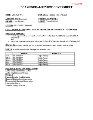
BOA GENERAL REVIEW COVERSHEET CASE: C15-2025-0013 BOA DATE: Monday, May 12th, 2025 ADDRESS: 3505 Greenway OWNER: Lynn Sherman COUNCIL DISTRICT: 9 AGENT: Donna D. Carter ZONING: SF-2-CO-NP (Hancock) LEGAL DESCRIPTION: LOT 2 KNIGHT KENNETH E RESUB OF PT LT 7 BEAU SITE VARIANCE REQUEST: • • setback requirements to decrease the minimum front yard setback from 25 feet (required) to 23 feet (requested) and impervious coverage requirements to increase I.C. from 45% (maximum allowed) to 54.5% (requested) SUMMARY: remodel, maintain and add an addition to an existing 2 story Single-Family residence ISSUES: natural site conditions, drainage and protected trees ZONING LAND USES Site North South East West SF-2-CO-NP SF-2-CO-NP SF-2-CO-NP SF-2-CO-NP SF-2-CO-NP Single-Family Single-Family Single-Family Single-Family Single-Family NEIGHBORHOOD ORGANIZATIONS: Austin Independent School District Austin Neighborhoods Council CANPAC Friends of Austin Neighborhoods Hancock Neighborhood Association Homeless Neighborhood Association Preservation Austin Save Our Springs Alliance ITEM08/1 April 23, 2025 Ms.. Donna Carter 3505 Greenway Austin TX, 78705 Property Description: LOT 2 KNIGHT KENNETH E RESUB OF PT LT 7 BEAU SITE Re: C15-2025-0013 Dear Donna, Austin Energy (AE) has reviewed your application for the above referenced property, requesting that the Board of Adjustment consider a variance request from LDC Section 25-2-492 at 3505 Greenway. Austin Energy does not oppose the request, provided that any proposed or existing improvements follow Austin Energy’s Clearance & Safety Criteria, the National Electric Safety Code, and OSHA requirements. All signage will need to stay out of Austin Energy easements and 5’ from existing underground electric lines. Any removal or relocation of existing facilities will be at the owner’s/applicant’s expense. Please use this link to be advised of our clearance and safety requirements which are additional conditions of the above review action: https://library.municode.com/tx/austin/codes/utilities_criteria_manual?nodeId=S1AUENDECR_1 .10.0CLSARE If you require further information or have any questions regarding the above comments, please contact our office. Thank you for contacting Austin Energy. Ashley Robinson, Planner III Austin Energy Public Involvement | Real Estate Services 2500 Montopolis Drive Austin, TX 78741 (512) 322-6050 ITEM08/2 ITEM08/3 Portion of the City of Austin Land Development Code applicant is seeking a variance from: ____________________________________________________________________________ LDC, section 25-2-492 Site Development Regulations 45% max. impervious (required) to ____________________________________________________________________________ 54.5% (requested). LDC Section 25-2-492 Site Development Regulations for a Front Yard ____________________________________________________________________________ setback of 25 ft (required) to 23 ft (requested). ____________________________________________________________________________ Section 2: Variance Findings The Board must determine the existence of, sufficiency of, and weight of evidence supporting the findings described below. Therefore, you must complete each of the applicable Findings Statements as part of your application. Failure to do so may result in your application being rejected as incomplete. Please attach any additional supporting documents. NOTE: The Board cannot grant a variance that would provide the applicant with a special privilege not enjoyed by others similarly situated or potentially similarly situated. I contend that my entitlement to the requested variance is based on the following findings: Reasonable Use The zoning regulations applicable to the property do not allow for a reasonable use because: ____________________________________________________________________________ The subject property provides access to the adjacent property reducing a significant portion of ____________________________________________________________________________ the impervious cover needs of the neighbor and reduces the right of way curbcuts in the ____________________________________________________________________________ subdivision, while, under current LDC interpretations, bears 100% of the impervious cover ____________________________________________________________________________ limitation. Due to the terrain and the original historic estate construction, drainage structures ____________________________________________________________________________ (counted as impervious cover) are required to control runoff from not only 3505 Greenway, but ____________________________________________________________________________ other utility easements and uphill lots in the subdivision. ____________________________________________________________________________ SEE ATTACHED 3505 Greenway Summary Variance Request Hardship a) The hardship for which the variance is requested is unique to the property in that: ____________________________________________________________________________ 1) The building and driveway were permitted and constructed ____________________________________________________________________________ i. under the 1981 City Code and 1983 LDC; ____________________________________________________________________________ ii. on a legal lot created as part of a re-subdivision of an historic estate that memorialized ____________________________________________________________________________ the historic driveway connecting the estate home on Hampton with Greenway; ____________________________________________________________________________ (Continued on Page 8) b) The hardship is not general to the area in which the property is located because: ____________________________________________________________________________ 1) The hardship is the result of the additive effect of COA LDC changes that are in conflict with the original development agreements that are particular to the subject property. ____________________________________________________________________________ 2) Natural site conditions, drainage and protected trees in close proximity to the house ____________________________________________________________________________ ____________________________________________________________________________ exacerbate the ability to remove landscape walls and their stabilizing walks as an impervious cover mitigation. (Continued on Page 8) ____________________________________________________________________________ City of Austin | Board of Adjustment General/Parking Variance Application (cid:21)(cid:18)(cid:28)(cid:18)(cid:21)(cid:21) | Page 5 of 8 ITEM08/4 Area Character The variance will not alter the character of the area adjacent to the property, will not impair the use of adjacent conforming property, and will not impair the purpose of the regulations of the zoning district in which the property is located because: ____________________________________________________________________________ The small storage and closet additions are located behind the main facade. They cannot be ____________________________________________________________________________ seen from the right of way. If the variance is NOT granted the area character is changed ____________________________________________________________________________ because the Owner would be forced to renogotiate the terms of the joint use driveway ____________________________________________________________________________ agreement which would probably require additional impervious cover and curb cuts to provide ____________________________________________________________________________ required access for 3509 Greenway. Regardless of the access solution, there would be more ____________________________________________________________________________ ground disturbance around protected trees and landscape that would alter the area character. Parking (additional criteria for parking variances only) Request for a parking variance requires the Board to make additional findings. The Board may grant a variance to a regulation prescribed in the City of Austin Land Development Code Chapter 25-6, Appendix A with respect to the number of off-street parking spaces or loading facilities required if it makes findings of fact that the following additional circumstances also apply: 1. Neither present nor anticipated future traffic volumes generated by the use of the site or the uses of sites in the vicinity reasonably require strict or literal interpretation and enforcement of the specific regulation because: ____________________________________________________________________________ N / A ____________________________________________________________________________ ____________________________________________________________________________ ____________________________________________________________________________ 2. The granting of this variance will not result in the parking or loading of vehicles on public streets in such a manner as to interfere with the free flow of traffic of the streets because: ____________________________________________________________________________ N / A ____________________________________________________________________________ ____________________________________________________________________________ ____________________________________________________________________________ 3. The granting of this variance will not create a safety hazard or any other condition inconsistent with the objectives of this Ordinance because: ____________________________________________________________________________ N / A ____________________________________________________________________________ ____________________________________________________________________________ ____________________________________________________________________________ 4. The variance will run with the use or uses to which it pertains and shall not run with the site because: ____________________________________________________________________________ N / A ____________________________________________________________________________ ____________________________________________________________________________ ____________________________________________________________________________ City of Austin | Board of Adjustment General/Parking Variance Application (cid:21)(cid:18)(cid:28)(cid:18)(cid:21)(cid:21) | Page 6 of 8 ITEM08/5 ITEM08/6 Additional Space (continued) _______________________________________________________________________________ ThePlease see the Attached Exhibits 1 through 8 _______________________________________________________________________________ Exhibit 1 - Subdivision Plan and Photos _______________________________________________________________________________ Exhibit 1a - 1979 Resubdivision Plat _______________________________________________________________________________ Exhibit 2 - Greenway Joint Driveway Easement (1983) _______________________________________________________________________________ Exhibit 3 - Apportioned Driveway Plans (1983) _______________________________________________________________________________ Exhibit 4 - 1983 Site Plan _______________________________________________________________________________ Exhibit 5 - 1983 Site Plan Analyzed _______________________________________________________________________________ Exhibit 6 - 1989 Pinkney Landscape Plan _______________________________________________________________________________ Exhibit 7 - Existing Conditions Plans _______________________________________________________________________________ Exhibit 8 - Proposed Plan _______________________________________________________________________________ _______________________________________________________________________________ Hardship (continued) _______________________________________________________________________________ a)The hardship for which the variance is requested is unique to the property in that: _______________________________________________________________________________ 1) (cont.) iii. based on the joint-use agreement recognized by the city and filed with Travis County _______________________________________________________________________________ contemporaneously with the development of the subdivision; and _______________________________________________________________________________ iv. subsequent driveway improvements were performed and paid for based on the agreement. _______________________________________________________________________________ 2) The terrain and protected trees require drainage and stormwater management with retaining _______________________________________________________________________________ walls and structures that count as impervious cover under today's rules. _______________________________________________________________________________ 3) The stone retaining walls required for this drainage system, unique to the lot, were design by _______________________________________________________________________________ renowned Landscape Architect C. C. Pinkney and should remain as part of his legacy. _______________________________________________________________________________ _______________________________________________________________________________ b) The hardship is not general to the area in which the property is located because: _______________________________________________________________________________ 3) The other lots on Greenway receive benefit of reduced curb cuts and impervious cover on _______________________________________________________________________________ their properties. _______________________________________________________________________________ 4) 3509 Greenway has more unencumbered land because the burden of the driveway access _______________________________________________________________________________ is solely borne by 3505 Greenway. _______________________________________________________________________________ 5) All of these attributes are unique to this site and no other lot in the subdivision is so _______________________________________________________________________________ encumbered. _______________________________________________________________________________ _______________________________________________________________________________ The existing impervious cover is 54.5%. Some landscape features can be removed, so a variance _______________________________________________________________________________ to allow the existing impervious cover to remain variance allows two cantilevered, attached storage _______________________________________________________________________________ areas of 239 SF to be added onto the existing structure. The front setback variance allows the _______________________________________________________________________________ existing carport to be modified to allow for a the turn into the carport entrance to be made more _______________________________________________________________________________ easily. _______________________________________________________________________________ _______________________________________________________________________________ _______________________________________________________________________________ _______________________________________________________________________________ City of Austin | Board of Adjustment General/Parking Variance Application (cid:21)(cid:18)(cid:28)(cid:18)(cid:21)(cid:21) | Page 8 of 8 ITEM08/7 ITEM08/8 easement is omi(cid:425)ed from the calcula(cid:415)on. Similarly, with landscape paving added over the years, current impervious is slightly less than 45% when the Easement is omi(cid:425)ed (Exhibit 7, Exis(cid:415)ng Condi(cid:415)ons Site Plan). The currently proposed plan (Exhibit 8, Current Proposed Site Plan) adds some new impervious cover but it, too, remains below the 45% max when the Easement area is omi(cid:425)ed from the calcula(cid:415)on. At this (cid:415)me, the Applicant requests, as part of the variance, that the following be allowed: 1. the en(cid:415)re land area associated with the city u(cid:415)lity records (10,982 SF – as used to determine Owner’s drainage fee) will be used as the “Size of the lot” for building calcula(cid:415)on purposes. 2. The area of the easement as defined in the recorded Perpetual Driveway Easement and confirmed by survey document (1,063.7 SF) NOT be included when calcula(cid:415)ng the impervious coverage for proposed maintenance, addi(cid:415)ons and renova(cid:415)ons of the exis(cid:415)ng residence on the subject property, based on the City Code of 1981, Sec(cid:415)on 13-2-126 3. Confirm that a por(cid:415)on of the exis(cid:415)ng carport in the carport setback that is no longer recognized by the LDC may remain, and that a small expansion of the carport into the front setback be allowed. The applicant understands that only the s(cid:415)pula(cid:415)ons allowed under the 1981 City Code and the subsequent 1982 amendments governing the joint use driveway and site calcula(cid:415)ons rela(cid:415)ng to the driveway are governing, therefore, the removal of some impervious cover installed on other areas of the property over the past 40 years may be required to be configured to be more aligned with the originally permi(cid:425)ed building and contemporaneous landscaped site plan. ITEM08/9 ITEM08/10 JOINT-USE DRIVEWAY AT 3505 GREENWAY 1. OVERVIEW. The driveway that runs along the common boundary between 3505 and 3509 Greenway1 has been in existence for up to 110+ years. Today, what remains of this driveway is jointly used by the resident owners of both addresses2 for ingress and egress to Greenway Street pursuant to a perpetual easement and right-of-way agreement (hereinafter the “Perpetual Driveway Easement”). The driveway extends from Greenway Street through the lot that is 3505 Greenway and, at its rear, onto the lot that is 3509 Greenway. The portion that burdens 3505 Greenway is for the joint use of both addresses (the “joint- use driveway”), and the portion that burdens 3509 Greenway is for its exclusive use. Importantly, as addressed further below, 3505 Greenway fronts on Greenway Street, and 3509 Greenway fronts upon the easement. At the time 3505 and 3509 Greenway were subdivided into existence and were acquired by the builder/developer who developed both properties and put the Perpetual Driveway Easement in place to accommodate their odd configuration and size limitations, the Austin City Code expressly exempted joint-use driveways having the exact, narrow fact pattern described above from the lot area, open space, yard area, coverage and other requirements imposed by what are now known as “zoning districts.”3 That exemption must continue to apply to the joint-use driveway at 3505 Greenway today; otherwise, an unconstitutional regulatory taking of real property interests has occurred, involving the real property interests of both property owners,4 their collective investments therein, and their reasonable expectations thereto – all of which are derived from a narrowly tailored set of code provisions that were drafted to address their unique fact situation. 2. BACKGROUND. Originally, the interior of Greenway Circle (where 3505 and 3509 Greenway are now located) was part of a single, unsubdivided estate lot owned by the developer of the neighborhood – Dr. J.R. Bailey. Around 1910, Dr. Bailey constructed his home on the unsubdivided estate lot5 (the “Bailey estate”) and extended a driveway from what is now Hampton Road on the east side of Greenway Circle, under and through a porte cochere attached to the home,6 and out the back of the property to the west. 1 The name of the street is actually “Greenway” without any other identifiers, although it often is appended with the word “Street.” Nevertheless, for purposes of this memo and to avoid confusion with other terms using a reference to “Greenway”, the street, itself, will be referred to as “Greenway Street”. 2 It is worth noting that 3505 and 3509 Greenway are still owned by the families who developed them: 3505 being the residence of the Sherman family, and 3509 being the residence of the Hoffman family. 3 At the time, they were referred to as “height and area districts.” See the Code of the City of Austin, 1981, Sec. 13-2- 126(a). 4 “An easement is an interest in land in the possession of another.” Restatement of the Law of Property. Section 450 (1944). See also, Marcus Cable Associates, L.P. v. Krohn, 90 SW3d 697, 700 (Tex. 2002); Stephen F. Austin State Univ. v. Flynn, 228 353, 358 (Tex. 2007). 5 See “Beau Site: A Case Study” attached as Exhibit A. See also Ordinance No. 040826-56, Exhibit A, p.22. 6 See porte cochere photos attached as Exhibit B. ITEM08/11 As depicted in aerial photographs from the Austin History Center, dated 1940 and 1958 (which are the earliest that could be located),7 the driveway extended from the Bailey home, out the back of the property between where 3505 and 3509 Greenway exist today, and onto Greenway Street. On March 27, 1979, the south portion of the interior of Greenway Circle that constituted what remained of the Bailey estate was subdivided into five (5) separate lots,8 including 3505 and 3509 Greenway (Lots 2 and 1, respectively) and the Bailey home (Lot 5). Notably, as part of the subdivision process, the northern boundary between 3505 and 3509 Greenway was platted to follow the curves of the driveway that still extended from the Bailey home’s porte cochere to Greenway Street.9 Then, as preparation for the development of 3505 and 3509 Greenway began, the driveway’s joint use between the two adjacent properties was memorialized in the Perpetual Driveway Easement, which was executed by the builder/developer on September 13, 1983, and filed in the Travis County records on September 16, 1983.10 The Building Permit for 3509 Greenway (No. 1983-010192 BP) was issued the same day that the Perpetual Driveway Easement was filed in the Travis County records – September 16, 1983. The Building Permit for 3505 Greenway (No. 1983-022728 BP) was issued several weeks later on November 2, 1983, and the Driveway & Sidewalk Permit for 3505 Greenway was issued the same day.11 Notably, the Driveway & Sidewalk Permit referenced under its “Conditions” the Perpetual Driveway Easement and the driveway’s permitted width(s) as follows: i) Perpetual Esmt* Agreement 3509 Greenway St.; and ii) Driveway 16’/17’. During the development process, the owners of 3505 and 3509 Greenway (i.e., the Shermans and the Hoffmans, respectively) decided to replace the driveway’s asphalt surface with more permeable concrete pavers. As part of that process, they worked with their builder/developer to prorate the cost for the resurfacing according to those portions of the driveway that would be used and useful to each residence. To that end, they evenly divided the cost associated with the front portion of the driveway which benefits both residences, and the Hoffmans assumed the total cost of the rear portion which solely benefits their residence at 3509 Greenway. This 7 See aerial photographs depicting driveway from the Austin History Center, dated 1940 and 1958, attached as Exhibit C. In each photo, the driveway runs from the second entrance to the Bailey estate off Hampton Road on the right side of the photo, through the back of the property and its tree cover (under the word “DRIVEWAY”), and out on the eastern extent of the property to Greenway Street. The 1958 aerial photo most clearly depicts the driveway running under and through the porte cochere on the south side of the Bailey home. 8 See the plat map of the “Kenneth E. Knight Resubdivision of Par Lot 7, Beau Site” attached as Exhibit D. 9 See map of Greenway Circle after the referenced subdivision, which is attached as Exhibit E. See also photos taken during the construction of 3505 and 3509 Greenway attached as Exhibit F that record the continued existence of the driveway through the interior of Greenway Circle from Greenway Street to the Bailey estate’s porte cohere. Eventually, the owners of the Bailey estate removed the portion of the driveway that extended into what was then the backyard of Lot 5. 10 See Perpetual Driveway Easement attached as Exhibit G. 11 See Driveway & Sidewalk Permit No. 1983-022728-DS attached as Exhibit H. 2 ITEM08/12 process was memorialized in a color-coded joint site plan that was used for the resurfacing project.12 Notably, it presciently followed the same method of prorated cost-sharing for joint- use driveway improvements that are imposed by the provisions of the Austin City Code today.13 3. SECTION 13-2-126 OF THE AUSTIN CITY CODE OF 1981. Section 13-2-126 of the City Code of 1981 and its predecessor Section 45-33 of the City Code of 1967, which contained the same pertinent provisions, 14 were in effect from before the subdivision of 3505 and 3509 Greenway out of the Bailey estate, and through the execution of the Perpetual Driveway Easement, the completion of the development of 3505 and 3509 Greenway, and the resurfacing of the joint driveway with more permeable material. Section 13-2-126 of the City Code of 1981 contains two subsections – Subsections (f) & (h) – that collectively exempt the joint-use driveway shared by 3505 and 3509 Greenway from lot area, open space, yard area, coverage and other requirements imposed by what are now known as “zoning districts.” a. Subsection (f) – 3505 & 3509 Greenway were developed in complete accord with it. Subsection (f) of 13-2-126 of the City Code of 1981 provides as follows: “Where two or more buildings are erected on one or more lots and an easement is provided for access to the buildings . . . , the buildings on the first lot . . . which abut on a street shall front upon the street and not upon then easement, but all other buildings to the rear of the same shall front upon the easement.”15 3505 and 3509 Greenway were developed in complete accord with this provision: i) the buildings on 3505 and 3509 Greenway were developed on different lots (i.e., more than one); ii) an easement was provided to 3509 Greenway for access to its residence (i.e., the Perpetual Driveway Easement); iii) 3505 Greenway fronts upon the street and not on the easement;16 and iv) 3509 Greenway fronts upon the easement.17 12 See Photos of the referenced joint site plan attached as Exhibit I. 13 See e.g., Austin City Code, Sections 13-3-148 and 25-6-418 (both entitled “Cost-Sharing for Joint-Use Driveway Improvements”). 14 Relative to the provisions of 13-2-126 of the City Code of 1981 cited in this memo, the wording of Section 13-2-126 and its predecessor, Section 45-33 of the City Code of 1967, are the same -- the only exception being an updated chapter reference. 15 The Code of the City of Austin, 1981, Sec. 13-2-126(f). This provision has been a part of the City of Austin’s ordinance from at least 1937. See Ordinance No. 370729-001, pp. 21-22. 16 See photos attached as Exhibit J. 17 See photos attached as Exhibit K. 3 ITEM08/13 b. Subsection (h) – Exempts the joint-use driveway from lot area, open space, yard area, coverage and other requirements. Subsection (h) of 13-2-126 of the City Code of 1981 provides in pertinent part as follows: “An easement or right-of-way as described in this section shall not be included as part of the lot area . . . required under Chapter 13-2 or of the lot size, open space, yard areas . . . and other requirements of the height and area district in which the property is located.”18 Notably, the “other requirements” referenced above included “coverage requirements.”19 Moreover, during the development of 3505 and 3509 Greenway, the referenced requirements became the “Revised Zoning Regulations” of a new Chapter 13-2A, which included impervious cover and other “Site Development Regulations” for the City’s “Residential Districts”20 that ultimately became the zoning districts of today. Since the Perpetual Driveway Easement preserves both an easement and right-of-way for the joint- use driveway shared by 3505 and 3509 Greenway,21 the sole requirement for an exemption from lot area, open space, yard area, coverage and other requirements under Subsection (h) of 13-2-126 has been more than met. c. Reliance on Subsection (j) is further evidence of reliance on 13-2-126 of the Austin City Code of 1981. Another indication that Section 13-2-126 of the Austin City Code of 1981 was relied upon in the development and construction of 3505 Greenway is the 20-foot set back line utilized for the carport, which is reflected on the site plan for 3505 Greenway22 and is consistent with Subsection (j) of Section 13-2-126 as it read at the time the house was permitted and constructed. 4. JOINT-USE DRIVEWAYS ARE FAVORED BY CITY POLICY. Joint-use driveways are desired and encouraged by stated City policy to this day. Some of the best evidence of this is found in Section 7 of the City’s Transportation Criteria Manual, entitled “Driveways.” which expressly provides as follows: “Best practice is to consolidate driveways with the use of joint use driveways during the redevelopment of existing property and the new development of vacant land”23 – notably, both cited development types were involved in the development of 3505 and 3509 Greenway and their joint-use driveway. 18 The Code of the City of Austin, 1981, Sec. 13-2-126(h) (emphasis added). The omitted last sentence of Subsection (h) provided as follows, which was relevant to 3509 Greenway: “Buildings facing on such easement or right-of-way shall be considered to front on a public street for the purpose of designation of front street line setback.” 19 See e.g., The Code of the City of Austin, 1981, Sec. 13-2-127(a)(4) & (b)(1)c. (pertaining to a “First Height and Area District”, which ultimately became one of the single-family zoning districts of today). 20 See Ordinance No. 840301-S, Exhibit A, Sections 2175 to 2179. 21 Perpetual Driveway Easement attached as Exhibit G. 22 See site plan for 3505 Greenway attached as Exhibit L. 23 Id. at Section 7.6.0, entitled “Access Management,” ¶2 (emphasis added). 4 ITEM08/14 “New joint use driveways are encouraged and will require a permanent joint use access easement and/or unified development agreement.”24 “Joint use driveways provide direct access to adjacent properties through a single driveway. This method of driveway placement is recognized as driveway consolidation and should be used as much as possible.”25 “The authority allowing for use of shared driveways is provided in LDC”26 [i.e., the City of Austin’s Land Development Code]. If the rules that incentivize the development of joint-use driveways are not enforced over time, the foregoing City policies will be undermined. And, perhaps more importantly, since they often require or involve the establishment of interlocking real property interests between the dominate estate that is burdened by the driveway and the servient estate that has easement and/or right-of-way rights therein, the legal implications for the City to “change the rules” after everything is place may well be costly from a monetary standpoint, as well. 24 Id at Section 7.6.4, entitled “Joint Use Driveways,” subpart B (emphasis added). 25 Id at Section 7.6.4, entitled “Joint Use Driveways” (emphasis added). 26 Id at Section 7.6.4, entitled “Joint Use Driveways,” subpart B. 5 ITEM08/15 Exhibit A ITEM08/16 Hancock Neighborhood Association I S e a r c h ... El Preserving the Hancock Neighborhood in Austin, Texas News Events Home Home .. History .. The Hancock Neighborhood: An Urbane Oasis About Meetings Join Contacts Documents References History Beau Site: A Case Study Slbrnitted byadmlncn Sat. 09/24nOt 1 • 15:36 By J o h n G . Bordie that is marked by land speculation, loan defaults, re-capital1zation and shrewd development planning. Some of the speculators and developers were individuals of honor and character, The area has a complex The area presently designated as Beau Site in City records encompasses the residential group between Harris Boulevard to the south, 38th Street to the north, Red River Ave. to the east and Waller Creek to the west. history others were quite the opposite. & been Beau Site's origins can be traced to the original state land Patent 163 V.2. State of Texas to Masillon Farley on March 1, 1849 that granted him Lots 6 & 9 of block Con the City of Austin plat; Lots 7 & 8 were granted to Farley a few days later. Lots 20, 21, U , granted to Farley in late 1848 and were sold to Jos. C. Swisher in January, 1849. 29 had by Swisher purchased lots 6 ft 9 in April 1849 for S130. All of these lots were sold then underway within the state subsequent to the conclusion of the war with Mexico. After the death of Dietrich, the lots were passed to his wife Sarah E. Dietrich as community property. She married J . W. Whipple in 1863 and the lots, valued at $8000 were transferred to both their names. These lots were posted as surety for a S13,775 dollar loan to William A. Blackbum who was trustee for Anna J . Robards. There were complications and loan default sales during the next six years. A quit claim to Whipple for lots 6, 9, 29 was filed In June 1875 in July 1875 (filed September 18791). Sometime prior to June 1877, Whipple had sold 3/8ths of an acre from lot 6 to J.B. Rector. Whipple sold the acreage remaining of the original property to Rector in May 1889 for $5640. This property was sold in April 1890 to Johnson, Ross and Terrell for $6250 before the founding of the Austin Country Club which would be located at its north boundary. Swisher to Francis Dietrich in April, 1850 for S1500. The increase in value by a factor of 11 within one year testifies to the land boom J.W. Hannig who had acquired a lien. Robards transferred the other property to Hannig by by Beau Site subdivision was developed venue, and a taste for discreet elegance. Lot sizes were, and still are, quite large. Several lots were substantially larger than one acre and a mmber were greater than two acres. It was intended that such lots were Bailey and the other developers of Beau Site viewed the location as being ideal for an exclusive community possessed of substantial attractions for those with the desire for space, proximity to a socially prestigious to be for the constructioo or estate-sized structures. Primarily located on 37th Street, Hampton Road, and Greenway, these lots reflected the space sizes of other estates fn the adjacent community such as the 2.5· Dr. J.R. Bailey around 1910 Dr. Bailey was one of the two individuals who worked out the fonmula for Novocaine when World War I prevented access to the German product. by acre site on Fairfax Walk north of 32nd Street. The exclusive nature of Beau Sale was underscored No bridges crossed the creek at those locations until the late 19505. Greenway was not opened to 38th Street until the mid 19705. Access to Beau Site was limited to the east end of 37th Street at Red River and the The cost of such large size lots would necessarily restrict the nature of development in the area but the developers established a series of deed restrictions and conditions incumbent on ownership for the future south end of Hampton at Harris. Its apparent isolation from the remainder of the city. 38th Street and Harris Avenue both stopped at Watler Creek. purchasers of the lots. This was intended to keep the area exclusively residential. As early as the 19205, deed restrictions began to appear which reflected concern that non-residential commerce might be poised to invade. Deed restrictions forbidding such commerce became extremely common at that time. Many restrictions simply ban commercial business: "no commercial business" being a common phrase in many deeds. During the 1930s and 19◄05 such a direct statement seemed to be insufficient as more powerful, specific and inclusive restrictions began to be used: "no trade, manufacturing, or mercantile establishment: no commercial garage; no livery stable would be penmitted and no animals may be kept.· Reflecting a 19205 view of proper commerce "no liquor [is] to be manufactured or sold within the area.· deed This desire to maintain the area exclusively residential is found in those purposes only:· To maintain the up-scale values of the neighborhood there could be "no subdivisions of existing units, no building to be closer than 25 feet to front of lot; and all structures [are] to be constructed of brick, stone, or concrete:· Surprisingly, given the goals of the developers, the framers of these restrictions were not very good at predicting future real estate Values because one of the common restrictions is that "no There were further urban planning house [is] to cost less than S5000. • garages must be kept, cars must regarding the nature of residential construction in order to maintain the exclusive coherent appearance of the neighborhood "all residences must face the fron t of the lot, restrictions which state that land is sold for residential lots only, and that all "structures [are] to be single family units for residential garaged; no motorcycles or three wheeled vehicles, no trailers shall be pennitted." Similar limitations were imposed to maintain the physical broad sweep of avenues and views be boulevards One exception to the view that the area was to be a network of such boulevards is Greenway. Inset into the curbln11 at the corner of 35th Street and Hampton Road is the blue and white tile street marker identifying Greenway as Green Way, the path to the golf course. There was also a public footpath from Hampton to 38th street east of 822 37th Street that was the shortcut to the golf course before Greenway was cut through to 38th Street. by A downside to these restrictions were those which emphasized race: during the 19205 and 19305 such restrictions excluded blacks; this was modified somewhat during the 1940s when the restrictions read "'only Caucasians" to reside. The restrictions limited residence but not ownership certain races. To ensure that such restrictions would be observed many deeds state ··1t shall to be lawful for anyone in Beau Site to sue for damages fn case of violation of these restrictions." Street names in the Beau Site area between Hampton and Greenway reflected the conventions of the times. 37th Street was originally Oakview Avenue and was renamed during the 19305 citywide renaming of east-west streets. Oakview then ended at Hampton Road. The segment intersection with Greenway. The south end of Greenway, according to the 1932 plats as a continuation of continues northward from Ro.id which, ;n shown on Austin Mayoral proclamation, begins at the corner of 35th and Hampton and has its north tenminus at 3700 Greenway. Perhaps for postal address clarity the plat names were modified to their present configuration ts city Hampton tum, its ITEM08/17 during the 1940s. Hanis Avenue and Hams Par1< Avenue were named for Sidon J. Hanis, a tum of the century developer in the area. Residents along those streets might reconsider the honor since Harris had many problems with his financiers. The last deed to mention him in the earty 1900s states process could not be served as S. J. Harris had gone to Cochise County, Arizona Territory! Cochise County is the location of Tombstone and its famous cemetery. • OUT OF THE ORDINARY: THE HISTORY OF HANCOCK CENTER up Ad<nowledgements Printer-friendly version login to post comments 3594 reads ITEM08/18 Exhibit B ITEM08/19 ITEM08/20 ITEM08/21 ITEM08/22 Exhibit C ITEM08/23 DRIVEWAYITEM08/24 3505 Greenway - 1958 aerial photo 0 00065 0013 -Miles 1:1,078 23 March 2023 T!il, P'<>Qac:t ,s for in'orm.tl onlll pu,,,.,, •nd ln•i ""1 ha·,tt b<o•n pr rfd and rtt;,• t enl;• me apJ)'"O:-rn>:e r•l ve :° l to,'".,. ,,111abht !Qr ll"' 1nff'm9. p1�!:1l_�:'f��! _'! , :.'__:> :': ; ! ! ! 9! •u•••>·•r.11 pu·pqsH :t_: - Jy ":_1 doe, •o'. r •'•"' a oa,t••·l,JIO-•.:: SV'\ley • ttte ,o, ourp e o' gtO it r•'•, c• DRIVEWAYITEM08/25 Exhibit D ITEM08/26 Exhibit E ITEM08/27 3505 & 3509 Greenway and Greenway Circle SF-2-CO-NP 0-NP sa\\e ITEM08/28 Exhibit F ITEM08/29 ITEM08/30 ITEM08/31 Exhibit G ITEM08/32 Exhibit H ITEM08/33 City of Austin DRIVEWAY & SIDEWALK PERMIT 3920735 3920735 PERMIT NO: 1983-022728-DS 3505 GREENWAY Type: RESIDENTIAL Status: Final Issue Date: 11/02/1983 Expiration Date: 10/25/1984 LEGAL DESCRIPTION: LOT 2 KNIGHT KENNETH E RESUB OF PT LT 7 BEAU SITE SITE APPROVAL DESCRIPTION: WORK PERMITTED: ISSUED BY: Res. Driveway & Sidewalk-2 Stry Frm Res W/Mas & Att Carport New Total Number of Driveways: Driveway width 1: Driveway width 2: Total linear Sqft of all Driveways: Total Number of Sidewalks: Total Linear SqFt Of All Curbs And Gutters: Number of Lanes Affected: Number of Days Lanes Affected: Number of Structures Affected: Number of days Structures Affected: TELEPHONE Fee Description Building Permit Fee Fee Amount Paid Date $40.00 11/02/1983 Total Fees; $40.00 Inspection requirements Driveway Inspection Sidewalks Inspection Fee Description Fee Amount Paid Date Conditions; Driveway 16'/17'No Letter Req On Drainage Perptual Esmt• Agreement 3509 Greenway St. Water Tap#G31422 Sewer Tap#109019 To Set Over BY ACCEPTING OR PAYING FOR THIS PERMIT YOU ARE DECLARING THAT YOU ARE THE OWNER OR AUTHORIZED BY THE OWNER THAT THE DATA SUBMITTED AT THE TIME OF APPLICATION WAS TRUE FACTS AND THAT THE WORK WILL CONFORM TO THE PLANS AND SPECIFICATION SUBMITTED HEREWITH. Section 25-11-94 E.XPIR A TION AND EXTENSION OF PERMIT(Active Permits will expire 180 days at 11 :59:59 pm after date of last inspection performed.) 202 Final Sidewalk 10/25/1984 Pass MIGRATED FROM PIER. Date Status I Comments I Inspector Page 1 of2 Printed: 04/04/2023 9:12 am ITEM08/34 City of Austin DRIVEWAY & SIDEWALK PERMIT 3920735 3920735 AUSTIN TRANSPORTATION DEPARTMENT (ATD) RIGHT OF WAY (ROW) PERMIT CONDITIONS **The permit conditions outlined below apply to ALL Right of Way Management permits unless otherwise noted on your permit and/or traffic control All Permit Types: 1. Permittee shall provide the following entities with specific dates, location, and dimension of work area, as applicable: a. Austin 3-1-1 (512-974-2000) a minimum of three (3) business days prior to ROW closures. Be prepared to provide permit number and closure information. (See our Division Memo and Mobility Guideline 04, Providing Notification, for additional guidance on submitting notification to Austin 3-1-1.) b. ATD Meter Shop for removal/protection of paystations and meters: 512-660-3293. c. A TD Sign Shop for removal/protection of signage: 512-97 4-4089. d. Austin Fire Department for all alley work: AFDAllev@austintexas.gov e. Austin Resource Recovery for Central Business District alley work: ARR.CBD@austintexas.gov f. Downtown Austin Alliance for emergency and long-term stationary work within the Central Business District (area outlined in red}: 512-469-1766. g. If police officers employed by agencies other than the City of Austin will be used to assist in directing traffic, applicant must notify APDSpecialevents@austintexas.gov at least three days prior to work with the name(s) and agency of the police officers to be employed, along with the date, time, and location where the officer(s) will be working. 2. All traffic control must be: a. In compliance with the current versions of the Texas Manual on Uniform Traffic Control Devices {TMUTCD) and the Transportation Criteria! Manual (TCM); b. Set and maintained by Competent Trained Traffic Control Personnel or Barricade Company; c. Removed from the ROW after approved work hours, returning ROW to full use. 3. City Officials and Inspectors must be allowed to inspect the right of way work zone. 4. ROW work must not conflict with: a. Special events as listed here - austintexas.gov/citystaqe. b. Existing temporary traffic control in the area. 5. ROW work must comply with the Sound Ordinance per Chapter 9-2-3. ROW work must not make noise audible to an adjacent business or residence between 10:30pm and 7:00am or operate a machine that separates, gathers, grades, loads, or unloads sand, rock, or gravel within 600 feet of a residence, church, hospital, hotel, or motel between 7:00pm and 6:00am, except for installation of concrete authorized by a separate non-peak hour concrete pour permit issued under City Code section 9-2-21.ROW work must maintain local access to all properties. 6. ROW work must maintain ADA compliant paths at all times. 7. Insurance and Bond must remain active and on file with ROW Management for the duration of the permit, as applicable. 8. Site contact must be available on a 24-hour basis, at a current phone number and e-mail. 9. Permit must be placed on dash of vehicles if parking space is permitted, as applicable. 10. Permitted parking does NOT allow for: a. Parking of personal vehicles. b. Occupancy of handicap, taxi, ride hailing, car share, valet, emergency, or other restricted parking zones. 11. Permittee is responsible for any costs incurred by the City to restore condition of the ROW. 12. Violations will be subject to penalties as provided for by law. 13. Use COA Standard Details, as applicable: a. For Trench and Street Repair- Series 1100 b. For Traffic Controls - Series 804S Permittee must adhere to all applicable local, state, and federal laws and regulations, including conditions of this permit. Permittee is responsible for actions performed under this permit. Permit and applicable standard detail(s) and/or traffic control plan must remain on site at all times. Only competent persons trained in traffic control shall set traffic control devices. Notify Austin 3-1-1 - (512)974-2000 - to report lane and sidewalk closures. Notify Right of Way Management - (512) 974-7180 - if conflicts exist prior to starting work. Failure to comply with permit conditions may result in delays, penalties, or red tag of job. SEE ADDITIONAL PERMIT CONDITIONS AT http://bit.ly/2y5uz0k. Page 2 of2 Printed : 04/04/2023 9: 12 am ITEM08/35 Exhibit I ITEM08/36 ITEM08/37 Exhibit J ITEM08/38 ITEM08/39 ITEM08/40 Exhibit K ITEM08/41 ITEM08/42 ITEM08/43 ITEM08/44 Exhibit L ITEM08/45 ITEM08/46 ISSUE DATE: --- I Y R A N M L E R P I I N O T C U R T S N O C R O F T O N R O F D E S A E L E R S I T N E M U C O D S H T I T I . I W E V E R M R E T N I I F O E S O P R U P E H T E B T O N Y A M D N A E T E L P M O C N I S I , L A V O R P P A Y R O T A L U G E R R O F D E S U . I N O T C U R T S N O C R O , I T M R E P R E T R A C A N N O D I 7 0 2 8 # R E B M U N N O T A R T S G E R S A X E T I t v r . G O I E C N E D S E R N A M R E H S n a l P e t i S d e s o p o r P . T S Y A W N E E R G 5 0 5 3 5 0 7 8 7 S A X E T , I N T S U A 4 PROPOSED SITE PLAN i - e c n e d s e R n a m r e h S - t i S y a w n e e r G 5 0 5 3 \ - e c n e d s e R n a m r e h S _ 6 1 1 2 0 2 \ e c n e d s e R n a m r e h S _ 6 1 1 2 0 2 i \ : T : : M P 5 3 0 1 2 3 2 0 2 / 4 / 8 WMLOT 3LOT 1LOT 4LOT 5N 22°43'53"E 95.37'N 22°47'00"E 55.04'S 30°31'20"E 48.56'S 24°58'40"W 63.13'N 58°16'07"W 8.02'N 52°44'28"W 123.01'(N 22°47'E 55')BEARING BASIS(N 58°13'W 8.02')(S 25°24'W 63.05')S 55°20'07"E 2.24'1/2" IRF BEARS12(S 30°53'E 48.78')(N 22°47'E 95.36')(N 52°51'W 123.14')25' B.L., PLAT5'x40' TELE. ESMT., PLAT10' TELE. ESMT., PLATWOODBLDG.20' CARPORT LINE30" LIVE OAK23" LIVE OAK14" SPANISH OAK13" SPANISH OAK14" SPANISH OAK11" SPANISH OAK15" SPANISH OAK26" LIVE OAK14" ELM18" ELM29" LIVE OAK26" ELM39" LIVE OAK0'40'20'80'160'N35013500350835103512350535093515350035043700Greenway StGreenway StHampton RdHampton RdHampton RdE 35th StE 35th StE 37th St1” = 40’ - When printed 17 x 111983 CONDITIONS & CONSTRUCTIONPHOTOSSubdivision and 1983 Construction PhotographsCONSTRUCTION PHOTOS SHOWING THE RELATIONSHIP OF 3505 GREENWAY TO THE ESTATE RESIDENCEEXHIBIT 106 October 2023ITEM08/47 EXHIBIT 1AITEM08/48 ITEM08/49 ITEM08/50 ITEM08/51 ISSUE DATE: --- I Y R A N M L E R P I I N O T C U R T S N O C R O F T O N R O F D E S A E L E R S I T N E M U C O D S H T I T I . I W E V E R M R E T N I I F O E S O P R U P E H T E B T O N Y A M D N A E T E L P M O C N I S I , L A V O R P P A Y R O T A L U G E R R O F D E S U . I N O T C U R T S N O C R O , I T M R E P R E T R A C A N N O D I 7 0 2 8 # R E B M U N N O T A R T S G E R S A X E T I t v r . G O I E C N E D S E R N A M R E H S n a l P e t i S d e s o p o r P . T S Y A W N E E R G 5 0 5 3 5 0 7 8 7 S A X E T , I N T S U A 4 PROPOSED SITE PLAN i - e c n e d s e R n a m r e h S - t i S y a w n e e r G 5 0 5 3 \ - e c n e d s e R n a m r e h S _ 6 1 1 2 0 2 \ e c n e d s e R n a m r e h S _ 6 1 1 2 0 2 i \ : T : : M P 5 3 0 1 2 3 2 0 2 / 4 / 8 ORIGINAL ARCHITECTS APPORTIONING OF DRIVEWAY COSTSEXHIBIT 3 Subdivision and 1983 Construction Photographs ---" )I I I I I I / I I I r I I .. I II J I ' I I.._ --./ lII . Driveway Paving Apportionment06 October 2023ITEM08/52 3,108.29 sf Buildings Imp Cov 3,108.29 sf Buildings Imp Cov 3,108.29 sf Buildings Imp Cov % 10,982 sf Total Area of Site 2,092.88 sf Site Imp Cov 2,092.88 sf Site Imp Cov 28.30 % Area of Imp Cov Total: 5,201.17 sf Total: 5,201.17 sf % 10,982 sf Total Area of Site 1,063.70 sf Total Area of Easement 47.36 % Total Area of Imp Cov Total: 4,137.47 sf % 10,982 sf Total Area of Site 37.67 % Area of Imp Cov Existing pervious - light green New Pervious - Dark green Joint easement - light blue Impervious building - Red Impervious other - Orange SEPTEMBER 16 1983 - EASEMENT SUPERIMPOSED BY CDA 1,063.70 sf 1,823.90 sf 3,108.29 sf 268.98 sf 1 1983 SITE PLAN Note: This sheet is the original 1983 plan, shown without any changes. The only additions by CDA on this sheet are the title, the graphic scale, the North arrow, the color coding, the joint access easement overlay, square footages and calculations. 0 1 2 5 10 25 50 1/8” = 1’ When printed 34 x 22 1/8" : 1' -0" PLAN N EXHIBIT 4 Color Added by CDAITEM08/53 3,108.29 sf Buildings Imp Cov 3,108.29 sf Buildings Imp Cov 3,108.29 sf Buildings Imp Cov % 10,982 sf Total Area of Site 2,092.88 sf Site Imp Cov 2,092.88 sf Site Imp Cov 28.30 % Area of Imp Cov Total: 5,201.17 sf Total: 5,201.17 sf % 10,982 sf Total Area of Site 1,063.70 sf Total Area of Easement 47.36 % Total Area of Imp Cov Total: 4,137.47 sf % 10,982 sf Total Area of Site 37.67 % Area of Imp Cov Existing pervious - light green New Pervious - Dark green Joint easement - light blue Impervious building - Red Impervious other - Orange SEPTEMBER 16 1983 - EASEMENT SUPERIMPOSED BY CDA 1,063.70 sf 1,823.90 sf 3,108.29 sf 268.98 sf 1 1983 SITE PLAN Note: This sheet is the original 1983 plan, shown without any changes. The only additions by CDA on this sheet are the title, the graphic scale, the North arrow, the color coding, the joint access easement overlay, square footages and calculations. 0 1 2 5 10 25 50 1/8” = 1’ When printed 34 x 22 1/8" : 1' -0" PLAN N EXHIBIT 5 SITE ANALYSISColor Added by CDAITEM08/54