ITEM04 C15-2024-0019 ADV PACKET JULY8 — original pdf
Backup
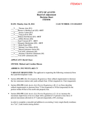
ITEM04/1 CITY OF AUSTIN Board of Adjustment Decision Sheet ITEM04 DATE: Monday June 10, 2024 CASE NUMBER: C15-2024-0019 ___Y____Thomas Ates (D1) ___-____Bianca A Medina-Leal (D2) -OUT ___Y____Jessica Cohen (D3) ___Y____Yung-ju Kim (D4) ___-____Melissa Hawthorne (D5) -OUT ___Y____Jeffery Bowen (D6) ___-____Janel Venzant (D7) -OUT ___-____Margaret Shahrestani (D8) -OUT ___Y____Brian Poteet (D9) ___Y____Michael Von Ohlen (D10) ___Y____Marcel Gutierrez-Garza (M) ___-____VACANT (Alternate) (M) ___Y____Suzanne Valentine (Alternate) (M) ___-____VACANT (Alternate) (M) APPLICANT: David Chace OWNER: Michael and Caroline Hinson ADDRESS: 2913 WESTLAKE CV VARIANCE REQUESTED: The applicant is requesting the following variance(s) from the Land Development Code: Section 25-2-492 (Site Development Regulations) from setback requirements to decrease the two minimum interior side yards setback from 10 feet (required) to 5 feet (requested). Section 25-2-551 (Lake Austin (LA) District Regulations) (B) (1) (a) from shoreline setback requirements to decrease from 75 feet (required) to 50 feet (requested) for the portion within 40 feet of the north side property line. Section 25-2-551 (Lake Austin (LA) District Regulations) (C) (3) (a) increase the maximum impervious cover on a slope with a gradient of 15 percent or less from 35 percent (maximum allowed) to 47.5 percent (requested), (54% existing) in order to complete a remodel and addition to an existing 2 story single-family residence in a “LA”, Lake Austin zoning district. ITEM04/2 Note: This subsection of the Land Development Code applies to a lot included in a subdivision plat recorded before April 22, 1982 or a tract that is not required to be platted, and that is located in an LA district. For the above address the LSD tract was acknowledged by COA per attached document as approved legal tract in March 2008 by COA DAC staff via C8I-2008-0096. The separate instrument #2004165487 for lot 14 Lago Valla Addition Subdivision deed was recorded in August 2004 but existed in current configuration March 1982 per Volume 8027, page 352 T.C.P.R then received utility service May 1984. In this section: SHORELINE means the 492.8 topographic contour line along the shores of Lake Austin. SHORELINE SETBACK means a line parallel to the shoreline and at a distance from the Land Development Code Section 25-2-551 Lake Austin (LA) District Regulations (A) (1) (2) shoreline that is prescribed in this section. (3) setback. SHORELINE SETBACK AREA means an area between the shoreline and the shoreline (B) This subsection specifies shoreline setbacks in a Lake Austin (LA) district. (1) The shoreline setback is: (a) 75 feet; or (b) 25 feet, if: (i) the lot is located in a subdivision plat recorded before April 22, 1982, or is a legal tract exempt from the requirements to plat; and (ii) the distance between the shoreline and the front lot line, or the property line of a legal tract, is 200 feet or less. (C) This subsection specifies lot width and impervious cover restrictions in a Lake Austin (LA) district. (3) For a lot included in a subdivision plat recorded before April 22, 1982, or a tract that is not required to be platted, impervious cover may not exceed: (a) 35 percent, on a slope with a gradient of 15 percent or less; (b) 10 percent, on a slope with a gradient of more than 15 percent and not more than 25 percent; (c) 5 percent, on a slope with a gradient of more than 25 percent and not more than 35 percent; or (d) 40 percent, if impervious cover is transferred under Subsection (D). BOARD’S DECISION: JUNE 10, 2024 Chair Jessica Cohen’s motion to postpone to July 8, 2024 (due to not having enough board members for voting purposes), Board member Suzanne Valentine second on 8-0 votes; POSTPONED TO JULY 8, 2024, at PDC, 6310 Wilhelmina Delco Drive, Event Center, 1st floor. FINDING: 1. The Zoning regulations applicable to the property do not allow for a reasonable use because: 2. (a) The hardship for which the variance is requested is unique to the property in that: ITEM04/3 (b) The hardship is not general to the area in which the property is located because: 3. The variance will not alter the character of the area adjacent to the property, will not impair the use of adjacent conforming property, and will not impair the purpose of the regulations of the zoning district in which the property is located because: Elaine Ramirez Executive Liaison for Jessica Cohen Chair ITEM04/4 From: To: Cc: Subject: Date: Attachments: Ramirez, Elaine Ramirez, Diana Re: Need postponement on 2913 Westlake Cove BOA tonight Wednesday, June 19, 2024 9:13:32 AM C15-2024-0019_2913 Westlake Dr Draft Notice.pdf 2024-06-17 - Hinson - Site Plan Exhibits REV.pdf External Email - Exercise Caution Good Morning Elaine, Diana, I have a question - the IC numbers on my 2913 Westlake Cove case have changed. They are lower than posted on the COA notice. I had the architect do the correct NSA / LA slope map calculations and we’re still slightly encroaching into the 75’ setback with a corner of the existing HVAC, but not nearly as much as I was led to believe by the first set of exhibits from the design team. As a result, we’re still over the 35% IC allowance in the 0-15 % slope but less than shown on the current app + cover letter and corresponding COA notice. We’re still in compliance with the COA notice (we are lower than posted for IC), the side yard 5’ setback request is the same, and the encroachment into the 75’ shoreline setback is still valid albeit only a corner of the existing building. Please see the updated drawings received late yesterday and your draft COA notice for quick reference. One the first proposed exhibit (page 2 on attached) : The existing IC is 51.59% and the proposed IC is 43.90% using a 50’ shoreline in front of the existing HVAC, then reverting to a 75’ shoreline for remainder of the rear yard. This proposed is less than the originally proposed 47.5% IC shown on the COA notice. Page 3 of the exhibit shows teh same existing 51.59% IC (with 75’ required shoreline) but the proposed is 41.75% IC using a 50’ shoreline setback across the entire rear yard. Again, less than the COA notice of 47.5% IC. The 5’ setback request is the same. So we need the 75’ reduction, the IC, and the 5’ as posted. Can you confirm that a brief updated memo + attached exhibits with the accurate numbers will suffice for the July 8 hearing’s packet? If so I can send via separate email. Or do you need the application amended + new power point? Thank you and I apologies for the confusion. Let me know your thoughts when you can. ITEM04/5 CAUTION: This is an EXTERNAL email. Please use caution when clicking links or opening attachments. If you believe this to be a malicious or phishing email, please report it using the "Report Message" button in Outlook. For any additional questions or concerns, contact CSIRT at "cybersecurity@austintexas.gov". Regards, David Chace TES I, LLC @Texas_excvattion_ solutions_llc On Jun 10, 2024, at 3:37 PM, david Cancialosi <dcc4681@icloud.com> wrote: Good afternoon Elaine and Diana, I’m so sorry for the late notice, but I just discovered that my architect has Covid and cannot attend, not even virtually. And there’s some outstanding questions on some of the relative Lake Austin setback and impervious cover calculations as we began to dive into those over the weekend For a last minute run through. He’s unable to make the necessary and unexpected changes. I need to request a postponement of this case to the July agenda if there is room. Can you please read this into the record at the start of tonight’s hearing and I will be there of course to answer any questions of the board, Should they have any. Thank you so much. Regards, David Chace Texas Excavation Solutions ITEM04/6 ITEM04/7 ITEM04/8 ITEM04/9 ITEM04/10 ITEM04/11 ITEM04/12 ITEM04/13 ITEM04/14 ITEM04/15 ITEM04/16 BOA GENERAL REVIEW COVERSHEET ITEM04/17 CASE: C15-2024-0019 BOA DATE: June 10th, 2024 ADDRESS: 2913 Westlake Cv OWNER: Caroline & Michael Hinson COUNCIL DISTRICT: 8 AGENT: David Chace ZONING: LA VARIANCE REQUEST: LEGAL DESCRIPTION: LOT 14 PLUS PT ADJ LAGO VILLA Section 25-2-492 (Site Development Regulations) from setback requirements to decrease the two minimum interior side yards setback from 10 feet (required) to 5 feet (requested). Section 25-2-551 (Lake Austin (LA) District Regulations) (B) (1) (a) from shoreline setback requirements to decrease from 75 feet (required) to 50 feet (requested) for the portion within 40 feet of the north side property line. Section 25-2-551 (Lake Austin (LA) District Regulations) (C) (3) (a) increase the maximum impervious cover on a slope with a gradient of 15 percent or less from 35 percent (maximum allowed) to 47.5 percent (requested), (54% existing) SUMMARY: remodel/addition to existing residence ISSUES: substandard lot & mix of slopes ZONING LAND USES Site North South East West LA LA LA LA SF-2/LA Single-Family Single-Family Single-Family Lake Austin Single-Family NEIGHBORHOOD ORGANIZATIONS: Austin Neighborhoods Council City of Rollingwood Friends of Austin Neighborhoods Neighborhood Empowerment Foundation Preservation Austin Save Our Spring Alliance TNR BCP – Travis County Natural Resources The Island on Westlake Owners Association ITEM04/18 May 20, 2024 David Chace 710 Hawthorne Loop Driftwood, TX 78619 Re: C15-2024-0019 Dear David, Property Description: LOT 14 PLUS PT ADJ LAGO VILLA Austin Energy (AE) has reviewed your application for the above referenced property, requesting that the Board of Adjustment consider a variance request from LDC Sections 25-2-551(D)(1)(a), 25-2-551(D)(3)(a), and 25-2-492(D) at 2913 Westlake Cove. Austin Energy does not oppose the request, provided that any proposed or existing improvements follow Austin Energy’s Clearance & Safety Criteria, the National Electric Safety Code, and OSHA requirements. Any removal or relocation of existing facilities will be at the owner’s/applicant’s expense. Please use this link to be advised of our clearance and safety requirements which are additional conditions of the above review action: https://library.municode.com/tx/austin/codes/utilities_criteria_manual?nodeId=S1AUENDECR_1 .10.0CLSARE If you require further information or have any questions regarding the above comments, please contact our office. Thank you for contacting Austin Energy. Cody Shook, Planner II Austin Energy Public Involvement | Real Estate Services 2500 Montopolis Drive Austin, TX 78741 (512) 322-6881 Cody.Shook@austinenergy.com ITEM04/19 ITEM04/20 ITEM04/21 ITEM04/22 ITEM04/23 ITEM04/24 ITEM04/25 ITEM04/26 ITEM04/27 ITEM04/28 ITEM04/29 ITEM04/30 ITEM04/31 ITEM04/32 ITEM04/33 ITEM04/34 25-2-551 LAKE AUSTIN (LA) DISTRICT REGULATIONS. (A) In this section: (1) SHORELINE means the 492.8 topographic contour line along the shores of Lake Austin. (2) SHORELINE SETBACK means a line parallel to the shoreline and at a distance from the shoreline that is prescribed in this section. (3) SHORELINE SETBACK AREA means an area between the shoreline and the shoreline setback. (B) This subsection applies in a Lake Austin (LA) district. (1) A shoreline setback area is excluded from impervious cover calculations. (2) A permanent improvement is prohibited in a shoreline setback area, except for a retaining wall, pier, wharf, boat-house, or marina, or a driveway to the structures. (3) Not more than 30 percent of the woody vegetation within a shoreline setback area may be removed. (4) Except for surveying or testing, vegetation within a shoreline setback area may not be removed before a building permit is issued. For surveying or testing, areas up to 15 feet wide may be cleared, and trees smaller than six inches in diameter may be removed. (5) Development is prohibited on land with a gradient that exceeds 35 percent. This prohibition does not apply to a fence, driveway, road or utility that cannot be reasonably placed elsewhere, or a pedestrian facility. (6) A sewage holding tank that is at least partially below ground level, or an effluent disposal site, must be at least 100 feet horizontally from the shoreline. A sewage facility drain field that uses soil as a filter medium may not be located on land with a gradient of more than 15 percent. (C) Except for a lot included in a subdivision plat recorded before April 22, 1982 or a tract that is not required to be platted, this subsection applies in an LA district. (1) The shoreline setback is 75 feet. (2) A lot that fronts on a cul-de-sac must have: (a) a chord width of not less than 33 feet at the front lot line; (b) a width of not less than 60 feet at the front yard setback line; and (c) a width of not less than 100 feet at all points 100 feet or more behind the front lot line. (3) Impervious cover may not exceed: (a) 20 percent, on a slope with a gradient of 25 percent or less; (b) 10 percent, on a slope with a gradient of more than 25 percent and not more than 35 percent; or (c) if impervious cover is transferred under Subsection (E), 30 percent. ITEM04/35 (D) This subsection applies to a lot included in a subdivision plat recorded before April 22, 1982 or a tract that is not required to be platted, and that is located in an LA district. (1) The shoreline setback is: (a) 75 feet; or (b) if the front line of the lot or tract is 200 feet or less from the shoreline, 25 feet. (2) The lot or tract must comply with the front yard, street side yard, interior side yard, and rear yard setback requirements applicable in an SF-2 district. (3) Impervious cover may not exceed: (a) 35 percent, on a slope with a gradient of 15 percent or less; (b) 10 percent, on a slope with a gradient of more than of 15 percent and not more than 25 percent; (c) 5 percent, on a slope with a gradient of more than 25 percent and not more than 35 percent; or (d) if impervious cover is transferred under Subsection (E), 40 percent. (E) In an LA district, a person may transfer impervious cover in accordance with this subsection. (1) Impervious cover may be transferred only: (a) between tracts within an LA district; and (b) from land with a gradient of 35 percent or less, to land with a gradient of 15 percent or less. (2) Land from which impervious cover is transferred may not be developed. The land must either remain undisturbed or be restored to a natural state. (3) A transfer of impervious cover must be described in a restrictive covenant that runs with the land, is approved by the city attorney, and is recorded in the county deed records. Source: Section 13-2-631; Ord. 990225-70; Ord. 031211-11. ITEM04/36 ITEM04/37 ITEM04/38 ITEM04/39 ITEM04/40 ITEM04/41 ITEM04/42 ITEM04/43 ITEM04/44 ITEM04/45