ITEM02 C15-2024-0013 ADV PACKET MAY 13 PART1 — original pdf
Backup
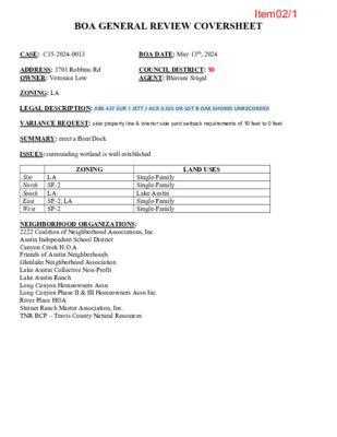
BOA GENERAL REVIEW COVERSHEET CASE: C15-2024-0013 BOA DATE: May 13th, 2024 ADDRESS: 3701 Robbins Rd OWNER: Veronica Lew COUNCIL DISTRICT: 10 AGENT: Bhavani Singal ZONING: LA LEGAL DESCRIPTION: ABS 437 SUR 1 JETT J ACR 0.505 OR LOT B OAK SHORES UNRECORDED VARIANCE REQUEST: side property line & interior side yard setback requirements of 10 feet to 0 feet. SUMMARY: erect a Boat Dock ISSUES: surrounding wetland is well established ZONING LAND USES LA SF-2 Site North South LA East West SF-2; LA SF-2 Single-Family Single-Family Lake Austin Single-Family Single-Family NEIGHBORHOOD ORGANIZATIONS: 2222 Coalition of Neighborhood Associations, Inc. Austin Independent School District Canyon Creek H.O.A. Friends of Austin Neighborhoods Glenlake Neighborhood Association Lake Austin Collective Non-Profit Lake Austin Ranch Long Canyon Homeowners Assn Long Canyon Phase II & III Homeowners Assn Inc. River Place HOA Steiner Ranch Master Association, Inc. TNR BCP – Travis County Natural Resources Item02/1 April 16, 2024 Vani Singal, Workshop No. 5 5409 Woodrow Ave #C Austin TX, 78756 Re: C15-2024-0013 Dear Vani, Property Description: ABS 437 SUR 1 JETT J ACR 0.505 OR LOT B OAK SHORES UNRECORDED Austin Energy (AE) has reviewed your application for the above referenced property, requesting that the Board of Adjustment consider a variance request from LDC Section 25-2-1176(A)(3) at 3701 Robbins Rd. Austin Energy does not oppose the request, provided that any proposed or existing improvements follow Austin Energy’s Clearance & Safety Criteria, the National Electric Safety Code, and OSHA requirements. Any removal or relocation of existing facilities will be at the owner’s/applicant’s expense. Please use this link to be advised of our clearance and safety requirements which are additional conditions of the above review action: https://library.municode.com/tx/austin/codes/utilities_criteria_manual?nodeId=S1AUENDECR_1 .10.0CLSARE If you require further information or have any questions regarding the above comments, please contact our office. Thank you for contacting Austin Energy. Cody Shook, Planner III Austin Energy Public Involvement | Real Estate Services 2500 Montopolis Drive Austin, TX 78741 (512) 322-6881 Cody.Shook@austinenergy.com Item02/2 Board of Adjustment General/Parking Variance Application DevelopmentATX.com | Phone: 311 (or 512-974-2000 outside Austin) For submittal and fee information, see austintexas.gov/digitaldevelopment WARNING: Filing of this appeal stops all affected construction activity. This application is a fillable PDF that can be completed electronically. To ensure your information is saved, click here to Save the form to your computer, then open your copy and continue. The Tab key may be used to navigate to each field; Shift + Tab moves to the previous field. The Enter key activates links, emails, and buttons. Use the Up & Down Arrow keys to scroll through drop-down lists and check boxes, and hit Enter to make a selection. The application must be complete and accurate prior to submittal. If more space is required, please complete Section 6 as needed. All information is required (if applicable). For Office Use Only Case # C15-2024-0013 ROW # 13293456 Tax # 0133210306 Section 1: Applicant Statement Street Address: 3701 Robbins Rd, Austin, TX 78730 Subdivision Legal Description: ABS 437 SUR 1 JETT J ACR 0.505 OR LOT B OAK SHORES UNRECORDED Lot(s): Outlot: Zoning District: LA I/We Workshop No. 5 Block(s): Division: Council District: 10 on behalf of myself/ourselves as authorized agent for Heidi Lew and Veronica Lew affirm that on Month March , Day 8 , Year 2024 , hereby apply for a hearing before the Board of Adjustment for consideration to (select appropriate option below): Erect Attach Complete Remodel Maintain Other: Type of Structure: Boat dock City of Austin | Board of Adjustment General/Parking Variance Application 2/9/22 | Page 4 of 8 Item02/3 Portion of the City of Austin Land Development Code applicant is seeking a variance from: 25-2-1176 (A)(3)- SITE DEVELOPMENT REGULATIONS FOR DOCKS, MARINAS, AND OTHER LAKEFRONT USES for a side yard setback of 10 ft. (Required) to 0 ft. (proposed) to allow for a new boat dock to be built where an existing boat dock already is within the setback on the side property line. Section 2: Variance Findings The Board must determine the existence of, sufficiency of, and weight of evidence supporting the findings described below. Therefore, you must complete each of the applicable Findings Statements as part of your application. Failure to do so may result in your application being rejected as incomplete. Please attach any additional supporting documents. NOTE: The Board cannot grant a variance that would provide the applicant with a special privilege not enjoyed by others similarly situated or potentially similarly situated. I contend that my entitlement to the requested variance is based on the following findings: Reasonable Use The zoning regulations applicable to the property do not allow for a reasonable use because: The existing boat dock was erected before 1984, and needs to be replaced. The current dock does not have enough clearance above the waterline to accommodate modern boats. Rebuilding the dock with an increase in height will allow a reasonable use enjoyed by other homeowners on the lake. Additionally, building a new dock in another location on the waterfront would create an unreasonable impact on the shorefront ecology, wetland biology, and the lakebed that could be avoided by rebuilding in the existing location. Hardship a) The hardship for which the variance is requested is unique to the property in that: The existing boat dock is located immediately adjacent to the neighbor's boat dock, on the property line. The boat dock has been in the same location for more than 40 years. The surrounding wetland is well established and the lakebed is settled around the existing cuts. b) The hardship is not general to the area in which the property is located because: An analysis of 1984 aerial views shows few lots in the area with boat docks. More recently developed lots have built their docks to comply with current setback requirements. City of Austin | Board of Adjustment General/Parking Variance Application 2/9/22 | Page 5 of 8 Item02/4 Area Character The variance will not alter the character of the area adjacent to the property, will not impair the use of adjacent conforming property, and will not impair the purpose of the regulations of the zoning district in which the property is located because: The neighbor on the shared lot line also has a non-complying boat dock immediately next to ours. Rebuilding in the same location will not alter the character or use of their property. The use of other nearby conforming properties will not be affected at all. The zoning setback regulations are intended to protect privacy and avoid overcrowding by promoting a feeling of openness. The proposed boat dock, as an accessory structure with few enclosed spaces, will honor the feeling of openness. Privacy screening is built into the design of the proposed dock. Parking (additional criteria for parking variances only) Request for a parking variance requires the Board to make additional findings. The Board may grant a variance to a regulation prescribed in the City of Austin Land Development Code Chapter 25-6, Appendix A with respect to the number of off-street parking spaces or loading facilities required if it makes findings of fact that the following additional circumstances also apply: 1. Neither present nor anticipated future traffic volumes generated by the use of the site or the uses of sites in the vicinity reasonably require strict or literal interpretation and enforcement of the specific regulation because: 2. The granting of this variance will not result in the parking or loading of vehicles on public streets in such a manner as to interfere with the free flow of traffic of the streets because: 3. The granting of this variance will not create a safety hazard or any other condition inconsistent with the objectives of this Ordinance because: 4. The variance will run with the use or uses to which it pertains and shall not run with the site because: City of Austin | Board of Adjustment General/Parking Variance Application 2/9/22 | Page 6 of 8 Item02/5 Section 3: Applicant Certificate I affirm that my statements contained in the complete application are true and correct to the best of my knowledge and belief. Applicant Signature: Date: 03.08.2024 Applicant Name (typed or printed): Vani Singal, Workshop No. 5 Applicant Mailing Address: 5409 Woodrow Ave #C City: Austin State: TX Zip: 78756 I affirm that my statements contained in the complete application are true and correct to the best of my knowledge and belief. Phone (will be public information): Email (optional – will be public information): Section 4: Owner Certificate Owner Signature: Owner Name (typed or printed): Owner Mailing Address: City: Phone (will be public information): Email (optional – will be public information): Section 5: Agent Information Agent Name: Agent Mailing Address: City: Phone (will be public information): Email (optional – will be public information): Date: State: Zip: State: Zip: Section 6: Additional Space (if applicable) Please use the space below to provide additional information as needed. To ensure the information is referenced to the proper item, include the Section and Field names as well (continued on next page). City of Austin | Board of Adjustment General/Parking Variance Application 2/9/22 | Page 7 of 8 Item02/6 03/07/2024 Board of Adjustment City of Austin 6310 Wilhelmina Delco Dr. Austin, TX 78752 Re: Summary letter for 3701 Robbins Rd 25-2-1176 (A)(3)- SITE DEVELOPMENT REGULATIONS FOR DOCKS, MARINAS, AND OTHER LAKEFRONT USES for a side yard setback of 10 ft. (Required) to 0 ft. (proposed) to allow for a new boat dock to be built where an existing boat dock already is within the setback on the side property line. Dear Board Members: 3701 Robbins Rd is within the Limited Purpose Jurisdiction of the City of Austin on the shore of Lake Austin. The site currently contains a new home and an existing non-compliant dock with two boat slips. The dock was constructed on the north property line prior to 1984, and needs to be replaced. The current dock has a clearance of 7’ from the waterline to the bottom of the second level, which does not accommodate most modern boats. We propose building a new dock in the existing location, retaining some existing piles, the existing bulkhead and lakebed cuts, while increasing the overall height of the dock. Increasing the height of the dock will allow for a reasonable use by the homeowner. Below are some photos of the existing dock. Building the new dock in its existing location will have minimal impact on the shoreline and existing wetlands compared to the impact of completely relocating it to comply with current code. In the more than forty years since the boat dock was constructed many waterfront plants, grasses, and trees have grown to maturity. Building a new dock in another location on the waterfront would create impact on the shorefront ecology that can be avoided by rebuilding in the existing location. Rebuilding in the same location will not alter the character or use of the area. This boat dock and the neighbors boat dock are next to each other on the shared property line, and have been for two decades. The use of other nearby conforming properties will not be affected at www.workshopno5.com 5409 Woodrow Ave, Unit C, Austin, TX 78756 Item02/7 all. The proposed boat dock will be open and airy with carefully placed screening to allow for privacy. On behalf of the owners, Heidi and Veronica Lew, I ask you to grant this application for a BOA variance. Sincerely, Vani Singal Architect Workshop No.5 LLC www.workshopno5.com 5409 Woodrow Ave, Unit C, Austin, TX 78756 Item02/8 ADVANCED CONSULTING ENGINEERS Civil Engineering Consultants, Planners ADV Consulting Engineers, Inc. dba T.B.P.E. Firm No. F-10 Phone: 5524 Bee Cave Road, Suite I-4 Austin, Texas 78746 March 7, 2024 Board of Adjustment Development Services Department City of Austin P.O. Box 1088 Austin, Texas 78767 Re.: Lew Family Boat Dock 3701 Robbins Road Austin, Texas 78730 Dock Placement Variance Dear Sir; Sincerely, Ashraf T. Ahsanullah, P.E. President at:la This letter is a variance request to allow for placement of proposed dock at the same location as an in-place existing dock. This boat dock site consists of an existing cut in slip with existing boat dock in-place, which will be replaced by the proposed boat same location with same footprint, except for height of dock. Their is an existing bulkhead that satisfies the requirement of lining up the proposed dock placement at the same spot as the existing dock with minimal impact to the lake front. The Site is located in Lake Austin Watershed classified as Water Supply Rural. This allowance would enable the property owners a reasonable use of the property and does not create a significant adverse impact to the lake front, avoids unnecessary bulkhead modifications and offers minimal impact to the lake front environment considering that the dock is located in the FEMA 100 year flood plain and in the Critical Water Quality Zone (CWQZ). Moreover it is a minimum impact change necessary to avoid encroaching into the wetlands just west of the existing dock as per the ERI report if relocating the proposed dock. We look forward to getting this BOA variance approvals from the City of Austin in the spirit of the ordinance. Item02/9 Item02/10 BOARDS FENCE LOCATION PRIOR TO CLEARING, GRADING AND PAVING X X X X X X X X C.R.Z. BOARDS WOOD CHIP MULCH AREA (8") DEPTH X X TEMPORARY ACCESS ROAD, EXISTING ROADWAY OR EASEMENT AS APPROVED X X X X X X X X X X PERMEABLE PAVING AREA CURB X X X FENCE LOCATION DURING PERMEABLE PAVING INSTALLATION C.R.Z. LINEAR CONSTRUCTION THROUGH TREES TREES IN PAVING AREA LIMIT OF CONSTRUCTION LINE AS SHOWN ON PLAN NATURAL AREAS CRITICAL ROOT ZONE (C.R.Z.) RADIUS = 12 mm PER mm (1 FT. PER INCH) OF TRUNK DIAMETER X X X X X X X MINIMUM NESESSARY WORK AREA (WOOD CHIP MULCH 8'' DEPTH) BLDG. X X X X X X X X X X X C.R.Z. ADD BOARDS STRAPPED TO TRUNK DUE TO CLOSENESS OF FENCE LESS THAN 1.5 m (5') FROM TRUNK. TREES NEAR CONSTRUCTION ACTIVITY X X X X X X X X X GROUP OF TREES INDIVIDUAL TREE CITY OF AUSTIN WATERSHED PROTECTION DEPARTMENT RECORD COPY SIGNED BY J. PATRICK MURPHY TREE PROTECTION FENCE LOCATIONS 11/15/99 ADOPTED THE ARCHITECT/ENGINEER ASSUMES RESPONSIBILITY FOR APPROPRIATE USE OF THIS STANDARD. STANDARD NO. 610S-1 GENERAL TREE NOTES TREE ANALYSIS LEGEND 1. 2. 3. 4. 5. 6. 7. 8. 9. TREE PROTECTION SHALL COMPLY WITH ALL REQUIREMENTS OF ENVIRONMENTAL CRITERIA MANUAL SECTION 3.6. TREE PROTECTION SHALL BE INSTALLED PRIOR TO THE BEGINNING OF ANY WORK ON SITE AND MAINTAINED UNTIL PROJECT COMPLETION. FENCING SHALL BE CHAIN-LINK MESH WITH A MINIMUM HEIGHT OF 5’, INSTALLED ON STEEL T-POSTS WITH A MINIMUM SPACING OF 10’ BETWEEN POSTS. FENCING SHALL BE CONTINUOUS AND CREATE A CLOSED, INACCESSIBLE AREA OF ROOT ZONE PROTECTION. FENCING SHALL NOT BE MOVED DURING THE PROJECT WITHOUT AUTHORIZATION BY CITY INSPECTOR. FENCING SHALL ENCOMPASS THE ENTIRETY OF THE CRZ NOT APPROVED FOR EITHER IMPACTS OR ALTERNATIVE PROTECTION. FENCED AREAS SHALL NOT BE USED FOR MATERIAL STORAGE AND SHALL BE KEPT FREE OF LITTER. MULCH IS REQUIRED FOR ANY PORTION OF THE CRZ THAT HAS NOT BEEN APPROVED FOR IMPACTS AND THAT CANNOT BE PROTECTED BY FENCING. MULCH SHALL BE OF A NATURAL HARDWOOD TYPE AND INSTALLED TO A MINIMUM DEPTH OF 8” ON ANY PORTION OF THE CRZ NOT PROTECTED BY FENCING. MULCH USED WITHIN THE HALF CRZ SHALL BE TOPPED BY DECKING TO PROVIDE ADDITIONAL PROTECTION AGAINST COMPACTION. MULCH SHALL NOT EXCEED 12” IN DEPTH, SHALL NOT CONTACT THE TRUNK, AND SHALL BE REMOVED AT THE END OF THE PROJECT. PORTIONS OF THE CRZ PROTECTED BY FENCING DO NOT REQUIRE MULCH UNLESS THE SOIL HAS BEEN DISTURBED, IN WHICH CASE THEY REQUIRE MULCH INSTALLED TO A DEPTH OF 3”. TRUNK OR BRANCH WRAPPING IS REQUIRED WHEN PROTECTIVE FENCING IS INSTALLED WITHIN 5’ OF THE TRUNK OR WHEN LOW GROWING MAJOR LIMBS ARE AT RISK OF DAMAGE FROM EQUIPMENT AND VEHICLES. DIMENSIONAL LUMBER SUCH AS 2X4S SHALL BE SECURED TO THE BRANCH BY WIRE OR STRAPS. WRAP SHALL NEVER BE SECURED DIRECTLY TO THE BRANCH BY SCREWS OR OTHER METHODS THAT PENETRATE OR OTHERWISE DAMAGE THE TREE. WRAP SHALL BE LOOSENED AND RETIGHTENED EVERY SIX MONTHS. CHEMICAL TOILETS AND CONCRETE WASHOUT AREAS SHALL NOT BE LOCATED WITHIN THE CRZ. PRUNING SHALL NOT REMOVE MORE THAN 25% OF THE LIVE CANOPY OF THE TREE, SHALL CONFORM TO THE ANSI A300 STANDARD FOR TREE CARE, AND SHALL BE PERFORMED BY A QUALIFIED ARBORIST. DEMOLITION WITHIN THE CRZ SHALL BE PERFORMED TO MINIMIZE DISTURBANCE TO THE CRZ AND ESPECIALLY TO FRESHLY EXPOSED AREAS OF SOIL. WHERE POSSIBLE MACHINERY SHOULD SIT ON EXISTING HARDSCAPE OR OUTSIDE THE CRZ AND WORK OUTWARDS FROM THE TREE. CONSTRUCTION METHODS SHALL NOT IMPACT THE CRZ BEYOND WHAT HAS BEEN APPROVED. FOUNDATION FORMWORK THAT LIES ADJACENT TO OR OVERLAPS THE HALF CRZ SHALL NOT BE ANCHORED WITHIN THE HALF CRZ BUT SHALL USE A STRONGBACK OR OTHER DESIGN TO AVOID THE HALF CRZ. NO STAKES LARGER THAN #5 REBAR PINS SHALL PENETRATE THE SOIL WITHIN THE HALF CRZ. TRENCHING WITHIN THE HALF CRZ SHALL BE PERFORMED BY AIR SPADE OR OTHER LOW IMPACT EXCAVATION METHOD WITHIN THE TOP 30”. CARE SHALL BE TAKEN TO AVOID DAMAGE TO THE BARK OF ROOTS. ROOTS LARGER THAN 1.5” IN DIAMETER SHALL NOT BE CUT WITHOUT AUTHORIZATION FROM CITY INSPECTOR. 2" X 4" X 8' PLANKING ATTACHED TO THE TRUNK OF PROTECTED TREE ON GRADE TREE FENCE WOOD CHIP MULCH AREA (8" DEPTH) EXISTING STRUCTURE IMPACTING CRZ NEW STRUCTURE IMPACTING CRZ NEW SITEWORK IMPACTING CRZ PROTECTED TREE FULL CRZ 1/4 CRZ 1/2 CRZ NON-PROTECTED TREE CRZ TREE 49" TEXAS ASH - TRUNK OFF SITE FULL CRZ = 7539 SF IMPACT OF NEW STRUCTURE = 0 SF IMPACT OF EXISTING STRUCTURE = 163 SF IMPACT OF SITEWORK = 0 SF TOTAL IMPACT 163/7539 = 2.16% TREE 19" PECAN- TRUNK OFF SITE NO IMPACT FROM CONSTRUCTION MULCH ENTIRE CRZ TO A DEPTH OF 8" CONSTRUCTION ACCESS PATH: 4 FOOT WIDE MINIMUM, ¾ INCH SHEETS OF PLYWOOD ON TOP OF 2 X 6 PLANKS ON TOP OF 8” OF HARDWOOD MULCH ON TOP OF THE EXISTING (UNDISTURBED GRADE). TREE FENCE MULCH TO A DEPTH OF 8" TREE FENCE TREE 3284- 40" MAGNOLIA NO IMPACT FROM CONSTRUCTION TREE 3285- 33" PECAN NO IMPACT FROM CONSTRUCTION LEGEND CM ( ) B.L. P.U.E. II D.E. ICV OH ½" IRON ROD FOUND (UNLESS STATED) CONTROL MONUMENT RECORD INFORMATION BUILDING LINE PUBLIC UTILITY EASEMENT AIR CONDITIONING UNIT WOOD PRIVACY FENCE DRAINAGE EASEMENT IRRIGATION CONTROL VALVE OVERHEAD ELECTRIC LINE GENERAL SITE NOTES 1. THE CONTRACTOR SHALL INSTALL EROSION/SEDIMENTATION CONTROLS AND TREE/NATURAL AREA PROTECTIVE FENCING PRIOR TO ANY SITE PREPARATION WORK (CLEARING, GRUBBING, OR EXCAVATION). THE PLACEMENT OF EROSION/SEDIMENTATON CONTROLS SHALL BE IN ACCORDANCE WITH THE ENVIORNMENTAL CRITERIA MANUAL AND THE APPROVED EROSION AND SEDIMENTATION CONTROL PLAN. PERMANENT EROSION CONTROLS: ALL DISTRUBED AREAS SHALL BE RESTORED PER COA RULES AND REGULATIONS. PROVIDE TREE PROTECTION PER COA GUIDELINES AT ALL TIMES. NO CUT OR FILL GREATER THAN 4" IS ALLOWED WITHIN THE 1/2 CRZ OF PROTECTED TREES (19" OR GREATER), AND THERE IS NO IMPACT ALLOWED WITHIN THE 1/4 CRZ. DEMOLITION WITHIN THE 1/4 AND 1/2 CRZ OF PROTECTED TREES MUST BE DONE WITH HAND TOOLS. 2. 3. 4. 5. 6. "LOT A" R 49' - 6" FULL C RZ R 1 2 ' - 4 1 / 2 " 1 / 4 C R Z R 2 5' - 3" 1/2 C R Z 49.5" Texas Ash (41" and 17" stems) R 19' - 0" 19" Pecan R 9' - 6" R 4' - 9" DN TREE LIST 3268 3269 3270 3279 3280 3281 3284 3285 15" Juniper 8" Hackberry 9" Hackberry 15" Hackberry 18" Hackberry 10" Cedar Elm 40" Magnolia 33" Pecan R 8' - 3" 1/4 CRZ R 1 6' - 6" 1/2 C 3285 Z R Z R L C UL 3' - 0" F R 3 3284 " 1 / 4 C R Z 0 ' - 0 R 1 R 2 0 ' - 0 " 1 / 2 C R Z R 4 0' - 0 " F U L L C R Z TREE 3284 = 40" MAGNOLIA FULL CRZ = 5024 SF IMPACT OF NEW STRUCTURE = 0 SF IMPACT OF EXISTING STRUCTURE = 0 SF IMPACT OF SITEWORK = 0 SF TOTAL IMPACT 0/5024 = %0 8 3 5 7 3 65 3 5 telephone pedestal wall ' 3 . 3 1 5 3 5 0 3 5 15.2' ' 5 . 2 1 3279 ' 2 . 1 1 5 2 5 19.1' 3280 0 2 5 3281 ' 4 . 0 1 5 1 5 10' Building Line per site plan 22" Pecan (S64°14'E 231.96') S64°16'15"E 231.16' wall 19" Pecan old rock wall ) . . W O R . ' 5 4 ( D A O R S N B B O R I e n i l t o l e v o b a s n u r e n i l y t i l i t u d a e h r e v o 15.7' 3268 ) ' 0 0 . 0 0 1 E 8 2 ° 5 2 N ' ( ' 0 0 . 0 0 1 ' E " 0 0 1 3 ° 5 2 N 5 3 5 GARAGE ' 0 . 4 2 l n a p e t i s r e p e n L g n d i i l i u B ' 5 1 l n a p e t i s r e p e n L g n d i i l i u B ' 0 4 l t n e m p o e v e D n i t s u A e k a L d n a 5 2 5 : k r a m h c n e b y r a r o p m e t n o l e g n a i r t l d e e s h c i ' 4 9 . 6 3 5 t a l l a w i g n v a p f o e g d e 3.4' TWO-STORY SINGLE- FAMILY RESIDENCE ATLAS-14 100 Year Flooplain and FEMA 500 Year Floodplain (0.2% annual chance) base flood elevation 515.8 ft. 0 2 5 10' Building Line per site plan 1 . 1 ' 3269 3270 15 5 xx TREE PRESERVATION PLAN - BOAT HOUSE 1/16" = 1'-0" 2 49.5" Texas Ash (41" and 17" stems) in concrete wall with wrought iron fence ground behind wall 493.80' NEW BOAT DOCK ON TOP OF EXISTING FOOTPRINT- NO CHANGE TO IMPERVIOUS CALCULATIONS top of wall: 493.64 lake bed: 490.73' 0 0 5 5 9 4 wood ramp conc. steps xx boat dock wall BOAT SLIP (DECK ABOVE) WOOD DECK BOAT SLIP (DECK ABOVE) WOOD DECK " 4 / 3 3 - 4' 2 " 3 - ' 3 lower level boat dock elevation: 493.6' Z Q W C d n a e Lin g uildin B tin s u A e k a L 5' 2 0 0 5 xx 3' 7 . 9 9 8') .8 9 9 4'W 1 ° 6 3 S ( W " 7 9'3 5 ° 5 3 S top of wall: 493.08' lake bed: 489.94' ground behind wall 492.60' f o e g d e r e t a w lake bed: 489.42' " 4 3/ 8 9' - 9 ground behind wall 492.83' top of wall: 493.24' e t e r c n o c lake bed: 489.92' ground behind wall 493.06' ground behind wall 493.11' xx top of wall: 493.24' lake bed: 490.18' to west gradient boundary of the Colorado River N64°46'20"W TREE LIST S64°19'04"E to west gradient boundary of the Colorado River 15" Juniper 8" Hackberry 9" Hackberry 15" Hackberry 18" Hackberry 10" Cedar Elm 40" Magnolia 33" Pecan 1 A300 3268 3269 3270 3279 3280 3281 3284 3285 TOP OF WATER ELEVATION JUNE 5, 2023 492.4 FT. R E V I R O D A R O L O C ) N I T S U A E K A L ( NOTE: SEE DRAWING ABOVE FOR TREE PRESERVATION INFO BOAT HOUSE SITE PLAN 1/16" = 1'-0" 1 " 0 - ' 0 1 Z Q W C d n a e Lin g uildin B tin s u A e k a L 5' 7 t n e m p elo v e D tin s u A e k a L d n a n pla e sit r e p 5 0 5 "LOT B" Heidi Wang Lew and Veronica Lew Document No. 2022128635 previously Angeline D. Thomas Volume 8840 Page 201 3285 " 0 - ' 0 1 xx N64°46'20"W xx 213.03' (N64°43'W 213.28') BEARING BASIS from prior suvery 75' - 0" 3284 25' - 0" 5 9 4 4 9 4 3 9 4 FEMA 100 Year Floodplain (1% annual chance) base flood elevation 496.5 ft. EXISTING BOAT DOCK 3027 N. LAMAR BLVD. #302B AUSTIN, TX 78705 512.243.8346 Seal: 09.27.2023 SHEET IS FORMATTED TO 22" x 34". SCALES ARE ONE HALF OF NOTED WHEN PRINTED AT HALF SIZE. LEW FAMILY BOAT DOCK 3701 ROBBINS RD AUSTIN TX 78730 Plan North True North Issue 1 09.27.2023 PERMIT SET Project Number, 21-004 Drawn By, BN Checked By, BS BOAT HOUSE SITE PLAN A100 Item02/11 Property Profile Legend Property Addresses Jurisdictions Fill Jurisdiction FULL PURPOSE LIMITED PURPOSE Notes 0 3/8/2024 300 600 ft This product is for informational purposes and may not have been prepared for or be suitable for legal, engineering, or surveying purposes. It does not represent an on-the-ground survey. This product has been produced by the City of Austin for the sole purpose of geographic reference. No warranty is made by the City of Austin regarding specific accuracy or completeness. Item02/12