ITEM10 C15-2022-0060 ADV PACKET 11-14 PART1 — original pdf
Backup
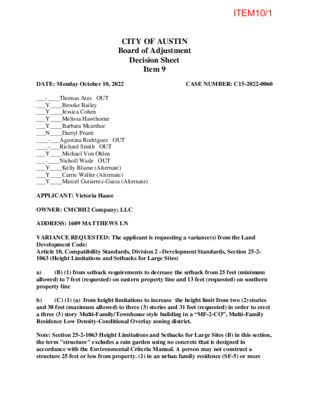
CITY OF AUSTIN Board of Adjustment Decision Sheet Item 9 DATE: Monday October 10, 2022 CASE NUMBER: C15-2022-0060 ___-____Thomas Ates OUT ___Y____Brooke Bailey ___Y____Jessica Cohen ___Y____Melissa Hawthorne ___Y____Barbara Mcarthur ___N____Darryl Pruett ____-___Agustina Rodriguez OUT ____-___Richard Smith OUT ___Y____Michael Von Ohlen ___-____Nicholl Wade OUT ___Y____Kelly Blume (Alternate) ___Y____Carrie Waller (Alternate) ___Y____Marcel Gutierrez-Garza (Alternate) APPLICANT: Victoria Haase OWNER: CMCBH2 Company; LLC ADDRESS: 1609 MATTHEWS LN VARIANCE REQUESTED: The applicant is requesting a variance(s) from the Land Development Code: Article 10, Compatibility Standards, Division 2 –Development Standards, Section 25-2- 1063 (Height Limitations and Setbacks for Large Sites) a) (B) (1) from setback requirements to decrease the setback from 25 feet (minimum allowed) to 7 feet (requested) on eastern property line and 13 feet (requested) on southern property line (C) (1) (a) from height limitations to increase the height limit from two (2) stories b) and 30 feet (maximum allowed) to three (3) stories and 31 feet (requested) in order to erect a three (3) story Multi-Family/Townhouse style building in a “MF-2-CO”, Multi-Family Residence Low Density-Conditional Overlay zoning district. Note: Section 25-2-1063 Height Limitations and Setbacks for Large Sites (B) in this section, the term "structure" excludes a rain garden using no concrete that is designed in accordance with the Environmental Criteria Manual. A person may not construct a structure 25 feet or less from property. (1) in an urban family residence (SF-5) or more ITEM10/1 restrictive zoning district; (C) The height limitations for a structure are: (1) two stories and 30 feet, if the structure is 50 feet or less from property: (a) in an SF-5 or more restrictive zoning district; BOARD’S DECISION: July 11, 2022 The public hearing was closed by Madam Chair Jessica Cohen, Board member Barbara Mcarthur motions to postpone to August 8, 2022; Board member Nicholl Wade seconds on a 11-0 vote; POSTPONED TO AUGUST 8, 2022; Aug 8, 2022 POSTPONED TO SEPTEMBER 12, 2022 BY APPLICANT; Sept 12, 2022 The public hearing was closed by Madam Chair Jessica Cohen, Board member Michael Von Ohlen motions to Approve with condition that it’s tied to site plan Item 8/3 as shown in the advance packet; Board member Melissa Hawthorne second on 8-3 vote (Board members Barbara Mcarthur, Darryl Pruett, Richard Smith nay); Motion fails; DENIED. RECONSIDERATION REQUEST: The applicant is requesting a variance(s) from the Land Development Code: Article 10, Compatibility Standards, Division 2 –Development Standards, Section 25-2-1063 (Height Limitations and Setbacks for Large Sites) a) (B) (1) from setback requirements to decrease the setback from 25 feet (minimum allowed) to 10 feet (requested) on eastern property line and 14 feet (requested) on southern property line b) (C) (1) (a) from height limitations to increase the height limit from two (2) stories and 30 feet (maximum allowed) to three (3) stories and 31 feet (requested) in order to erect a three (3) story Multi-Family/Townhouse style building in a “MF-2-CO”, Multi-Family Residence Low Density-Conditional Overlay zoning district. Note: Section 25-2-1063 Height Limitations and Setbacks for Large Sites (B) in this section, the term "structure" excludes a rain garden using no concrete that is designed in accordance with the Environmental Criteria Manual. A person may not construct a structure 25 feet or less from property. (1) in an urban family residence (SF-5) or more restrictive zoning district; (C) The height limitations for a structure are: (1) two stories and 30 feet, if the structure is 50 feet or less from property: (a) in an SF-5 or more restrictive zoning district. BOARD’S DECISION: RECONSIDERATION REQUEST – October 10, 2022 -Board member Michael Von Ohlen motions to reconsider the request; Board member Brooke Bailey second on 8-1 vote (Board member Darryl Pruett nay); RECONSIDERED; Applicant requested a postponement to November 14, 2022, Board members Granted the postponement request to November 14, 2022. FINDING: 1. The Zoning regulations applicable to the property do not allow for a reasonable use because: the compatibility regulations were intended to buffer single family uses from commercial uses, the triggering properties to the east and south of the subject tract have longstanding commercial uses that are not in need of the protections ITEM10/2 2. (a) The hardship for which the variance is requested is unique to the property in that: the site has 4 heritage protected trees, critical water quality zone and public utility easements that push developable area towards the triggering properties; the location of the trees creates challenge for building placement while also adhering to compatibility setbacks and height limitations. (b) The hardship is not general to the area in which the property is located because: this property is uniquely situated along a rail road track, adjacent to two properties that have compatibility triggering zoning but have long established commercial and industrial/warehouse uses. 3. The variance will not alter the character of the area adjacent to the property, will not impair the use of adjacent conforming property, and will not impair the purpose of the regulations of the zoning district in which the property is located because: the adjacent, compatibility triggering properties have long standing commercial and industrial/warehouses uses that are not intended to be buffered by compatibility regulations. ______________________________ Elaine Ramirez Executive Liaison ____________________________ Jessica Cohen Madam Chair forITEM10/3 CITY OF AUSTIN Board of Adjustment Decision Sheet Item-8 DATE: Monday September 12, 2022 CASE NUMBER: C15-2022-0060 __Y_____Thomas Ates __Y_____Brooke Bailey __Y_____Jessica Cohen __Y_____Melissa Hawthorne __N_____Barbara Mcarthur __N_____Darryl Pruett __-_____Agustina Rodriguez (out) __N_____Richard Smith __Y_____Michael Von Ohlen __Y_____Nicholl Wade __Y_____Kelly Blume (Alternate) __Y_____Carrie Waller (Alternate) __-_____Marcel Gutierrez-Garza (Alternate) APPLICANT: Victoria Haase OWNER: CMCBH2 Company; LLC ADDRESS: 1609 MATTHEWS LN VARIANCE REQUESTED: The applicant is requesting a variance(s) from the Land Development Code: Article 10, Compatibility Standards, Division 2 –Development Standards, Section 25-2- 1063 (Height Limitations and Setbacks for Large Sites) (B) (1) from setback requirements to decrease the setback from 25 feet (minimum a) allowed) to 7 feet (requested) on eastern property line and 13 feet (requested) on southern property line b) and 30 feet (maximum allowed) to three (3) stories and 31 feet (requested) in order to erect a three (3) story Multi-Family/Townhouse style building in a “MF-2-CO”, Multi-Family Residence Low Density-Conditional Overlay zoning district. (C) (1) (a) from height limitations to increase the height limit from two (2) stories Note: Section 25-2-1063 Height Limitations and Setbacks for Large Sites (B) in this section, the term "structure" excludes a rain garden using no concrete that is designed in accordance with the Environmental Criteria Manual. A person may not construct a structure 25 feet or less from property. (1) in an urban family residence (SF-5) or more restrictive zoning district; (C) The height limitations for a structure are: (1) two stories and ITEM10/4 30 feet, if the structure is 50 feet or less from property: (a) in an SF-5 or more restrictive zoning district; BOARD’S DECISION: July 11, 2022 The public hearing was closed by Madam Chair Jessica Cohen, Board member Barbara Mcarthur motions to postpone to August 8, 2022; Board member Nicholl Wade seconds on a 11-0 vote; POSTPONED TO AUGUST 8, 2022; Aug 8, 2022 POSTPONED TO SEPTEMBER 12, 2022 BY APPLICANT; Sept 12, 2022 The public hearing was closed by Madam Chair Jessica Cohen, Board member Michael Von Ohlen motions to Approve with condition that it’s tied to site plan Item 8/3 as shown in the advance packet; Board member Melissa Hawthorne second on 8-3 vote (Board members Barbara Mcarthur, Darryl Pruett, Richard Smith nay); Motion fails; DENIED. FINDING: 1. The Zoning regulations applicable to the property do not allow for a reasonable use because: the compatibility regulations were intended to buffer single family uses from commercial uses, the triggering properties to the east and south of the subject tract have longstanding commercial uses that are not in need of the protections 2. (a) The hardship for which the variance is requested is unique to the property in that: the site has 4 heritage protected trees, critical water quality zone and public utility easements that push developable area towards the triggering properties; the location of the trees creates challenge for building placement while also adhering to compatibility setbacks and height limitations. (b) The hardship is not general to the area in which the property is located because: this property is uniquely situated along a rail road track, adjacent to two properties that have compatibility triggering zoning but have long established commercial and industrial/warehouse uses. 3. The variance will not alter the character of the area adjacent to the property, will not impair the use of adjacent conforming property, and will not impair the purpose of the regulations of the zoning district in which the property is located because: the adjacent, compatibility triggering properties have long standing commercial and industrial/warehouses uses that are not intended to be buffered by compatibility regulations. ______________________________ Elaine Ramirez Executive Liaison ____________________________ Jessica Cohen Madam Chair forITEM10/5 BOA GENERAL REVIEW COVERSHEET RE-CONSIDERATION CASE: C15-2022-0060 BOA DATE: October 10th, 2022 COUNCIL DISTRICT: 5 AGENT: Victoria Haase ADDRESS: 1609 Matthews Ln OWNER: CMCBH2 Company LLC ZONING: MF-2-CO LEGAL DESCRIPTION: LOT 1 RESUB OF PT OF LOT 1 FITZHUGH J G & HENRY SUBD VARIANCE REQUEST: a) decrease the setback from 25 feet to 10 feet on eastern property line and 14 feet on southern property line b) increase the height limit from two (2) stories and 30 feet to three (3) stories and 31 feet SUMMARY: erect multi-family/townhouse dwelling units ISSUES: heritage trees, critical water quality zone and public utility easements ZONING MF-2-CO SF-6-CO; CS Site North South DR East SF-2 West MF-2 LAND USES Multi-Family Single-Family; Commercial Services Development Reserve Single-Family Multi-Family NEIGHBORHOOD ORGANIZATIONS: Austin Independent School District Austin Lost and Found Pets Austin Neighborhoods Council Friends of Austin Neighborhoods Go Austin Vamos Austin 78745 Homeless Neighborhood Association Matthews Lane Neighborhood Assn. Neighborhood Empowerment Foundation Onion Creek HOA Preservation Austin SELTexas Sierra Club, Austin Regional Group South Austin Neighborhood Alliance (SANA) ITEM10/6 MEMORANDUM DATE: September 21, 2022 TO: Members of the Board of Adjustment FROM: Ron Thrower & Victoria Haase – Thrower Design, LLC RE: C15-2022-0060 – 1609 Matthews Lane Request for Reconsideration On behalf of the landowners, this request is made for a reconsideration of the Board’s decision to deny the variance requests at the September 12, 2022, public hearing. We respectfully believe the Board made an error in their decision and provide additional information herein for the Board to consider before taking a final vote on this case. The vote taken on September 11, 2022, was very inconsistent with votes taken on 8 similarly situated cases between 2019 and 2021 for which the Board voted to support variances to Compatibility Standards of 25-2-1063 of the City of Austin Land Development Code. Further, there is data establishing reasonable use for this property, in terms of density. The data supports that this property is deprived of privileges that are enjoyed by other landowners that have MF-2 zoned properties. ITEM10/7 Similar Cases The following Board of Adjustment cases achieved successful variances to compatibility requirements of LDC 25-2-1063: 1. C15-2019-0056 – 1400 W. Oltorf Street Similar Variances Requested & Granted: 25-2-1063(B)(2) – to decrease the minimum setback requirement from 25ft to 0ft along the southern property line, adjacent to a compatibility triggering property. 25-2-1063(C)(1) – to increase the maximum compatibility height from 30ft to 45ft, if within 50ft or less of a compatibility triggering property. 25-2-1063(C)(2) - to increase the maximum compatibility height from 40ft to 45ft, if within 50ft and not more than 100ft of a compatibility triggering property. Triggering property – Undeveloped, SF-3 zoned Hardships: Critical Water Quality Zone, Floodplain 2. C15-2019-0014 – 411, 601 E Powell Lane, etc. Similar Variances Requested & Granted: 25-2-1063(B)(2) – to decrease the minimum setback requirement from 25ft to 15ft. 25-2-1063(C)(1) – to increase the maximum compatibility height from 2 stories and 30ft to 3 stories and 31ft, if within 50ft or less of a compatibility triggering property. Triggering property – Single Family use on SF-3 zoned property, Church use on MF-3 zoned property Hardships: Protected & Heritage Trees 3. C15-2019-0061 – 735 Springdale Road Similar Variances Requested & Granted: 25-2-1063(C)(2) - to increase the maximum compatibility height from 40ft to 48ft, if within 50ft and not more than 100ft of a compatibility triggering property. Triggering property – Single Family use on SF-3 zoned property Hardships: Critical Water Quality Zone, Floodplain (0.88 acres of 4.85= 18.14%) 2 ITEM10/8 4. C15-2020-0009 – 3219 Manor Road Similar Variances Requested & Granted: 25-2-1063(C)(2) - to increase the maximum compatibility height from 3 stories and 40ft to 60ft, if within 50ft and not more than 100ft of a compatibility triggering property. 25-2-1063(C)(3) - to increase the maximum compatibility height from 40ft plus one foot for each 10 feet of distance in excess of 100 feet from a compatibility triggering property to 60ft. Triggering property – Single Family use on SF-3 zoned property Hardships: Protected & Heritage Trees, access prohibitions, utilities 5. C15-2020-0013 – 2700 E 5th Street Similar Variances Requested & Granted: 25-2-1063(C)(2) - to increase the maximum compatibility height from 3 stories and 40ft to 4 stories and 56ft, if within 50ft and not more than 100ft of a compatibility triggering property. Triggering property – Single Family & Church uses on LR and GR zoned properties Hardships: lot shape and adjacency to railroad tracts 6. C15-2020-0053 – 900 Old Koenig Lane & 5916 N. Lamar Blvd Similar Variances Requested & Granted: 25-2-1063(B)(2) – to decrease the minimum setback requirement from 25ft to 0ft 25-2-1063(C)(1) – to increase the maximum compatibility height from 30ft to 60ft, if within 50ft or less of a compatibility triggering property. 25-2-1063(C)(2) - to increase the maximum compatibility height from 40ft to 60ft, if within 50ft and not more than 100ft of a compatibility triggering property. Triggering property – Church use on GR zoned property Hardships: Protected & Heritage Trees, Utilities 7. C15-2021-0096 – 5700 Grover Avenue & 5617 Roosevelt Avenue Similar Variances Requested & Granted: 25-2-1063(C)(2) - to increase the maximum compatibility height from 3 stories and 40ft to 4 stories and 45ft, if within 50ft and not more than 100ft of a compatibility triggering property. 3 ITEM10/9 25-2-1063(C)(3) - to increase the maximum compatibility height from 40ft plus one foot for each 10 feet of distance in excess of 100 feet from a compatibility triggering property to 45ft. Triggering property – School use on SF-3 zoned property, Single Family use on SF-3 zoned property Hardships: Critical Water Quality Zone, Floodplain, fire lane, easements 8. C15-2021-0101 – 201 & 403 E Koenig Lane, 5613 Avenue F Similar Variances Requested & Granted: 25-2-1063(C)(2) - to increase the maximum compatibility height from 3 stories and 40ft to 60ft, if within 50ft and not more than 100ft of a compatibility triggering property. 25-2-1063(C)(3) - to increase the maximum compatibility height from 40ft plus one foot for each 10 feet of distance in excess of 100 feet from a compatibility triggering property to 60ft. Triggering property – Single Family use on SF-3 zoned property Hardships: Lot configuration, utility easements Summary of Previous Cases 1. All but one case was specific to relaxing compatibility standards ADJACENT to single family zoned lots with 6 having existing homes and one with single family zoning that was vacant. 2. One of the cases was for a compatibility waiver to a church and another to a school. 3. None of the cases have the level of hardships as presented with the case on Matthews Lane. 4. All the cases were representative to conditions exactly as the Matthews Lane case – the subject property is a clean slate for development. We recognize that prior cases are not establishing any level of precedent to warrant automatic granting of compatibility waivers. Rather, the purpose of this exercise is to kindly remind the Board of previous cases where similar waivers to compatibility have been granted under the premise that not all waivers are equal just as not all hardships are equal. 4 ITEM10/10 Reasonable Use The Land Development Code establishes the criteria associated with a finding of reasonable use as: § 25-2-473 VARIANCE REQUIREMENTS (A) A variance from the requirements of this chapter, or a Neighborhood Conservation Combining District adopted under this chapter, may be granted under this division if, because of special circumstances of a property, the strict application of this chapter deprives the property owner of the privileges that are enjoyed by another person who owns property in the area that has the same zoning designation as the property for which the variance is requested. A variance to a regulation may not grant special privileges that are inconsistent with the limitations on the other properties in the area or on the district I which the property is located. (B) City Council adopted zoning districts which define specific density and intensity of development per each district. When City Council assigns a zoning district to a piece of land, the Council is establishing reasonable use, including density for that specific property. If necessary, Council can further define, beyond the minimum and maximums of each zoning district, through the application of a conditional overlay. As is the case for this Property, Council determined that MF- 3 was not appropriate or reasonable and instead adopted MF-2 for the subject tract with further specification than 10 units is a reasonable use and intensity of development as per the conditional overlay. Anything less than 10 units is impeding reasonable use, as determined by City Council. The following are developments of MF-2 zoned properties and the densities for each development. 1. SP-2019-0006C – Bluebonnet Townhomes – 2505 Bluebonnet Lane Density: 18 units per acre Avg. Unit size: 2,370 sf, 2BR Max Height: 3flrs @ 40ft. Density: 18 units per acre Avg. Unit size: 2,111 sf, 1+2BR Max Height: 3flrs @ 34ft. 1in. 2. SP-2006-0697C – Sola City Homes – 2520 Bluebonnet Lane 5 ITEM10/11 3. SP-2006-0587C – Verde Stone Creek Apartments – 751 W. Slaughter Lane Density: 16.5 units per acre Avg. Unit size: 929 sf, 1, 2+BR Max Height: 2flrs @ 26ft. The Property is deprived of achieving reasonable uses similar to other properties with similar zoning because a significant amount of land area is lost to hardships on the property because, 1. The City requires preservation of Heritage and Protected Trees, of which there are 4; 2. The City will not allow development in the Critical Water Quality Zone, located along the western property line, causing for new buildings to be placed closer to the triggering properties. 3. They City will not allow development in a utility easement, located along the western edge of the property, causing for new buildings to be placed closer to the triggering properties. 4. The commercially developed properties to the east and south of the Property were assigned SF-2 zoning at the time of annexation, which is non-compliant with the commercial and industrial development and use of the property then and today. The non- compliance of those properties was never rectified and now present a hardship for the subject Property. The following are excerpts taken from the original, 1984 Land Development Code with regards to Compatibility and are important context to the conception of the Compatibility Standards: Section 1186 above is clear that the intent at the initial adoption of the legislation was to make sure that differing land uses can exist harmoniously, side by side in Austin. However, the harmony is irrelevant when the adjacent land use triggering the compatibility does not meet the Purpose statement of Section 4701 below. 6 ITEM10/12 Section 4701 PURPOSE – The sole purpose of compatibility standards is clear – preserve and protect single-family neighborhoods. The adjacent land use is not a single-family neighborhood, was not intended to be part of a single-family neighborhood, is established with a use that does not belong in a single-family neighborhood nor would ever be allowed in a single-family neighborhood. Therefore, should not be afforded protections for privacy, etc. of Compatibility Standards. Sections 4715 and 4716 HEIGHT AND SETBACK REQUIREMENTS and PURPOSE – These standards are meant to ensure that buildings will not be significantly taller than single-family residences and to further ensure that properties developing proximate to HOMES will not over-shadow or burden said HOMES. To be clear, the nearest home to the Matthews Lane property is far outside the compatibility height plane at more than 130ft of distance. Further, the Subject property is at a lower elevation, by 4-6ft due to topographic change that favors the single-family homes to the east. Additionally, the subject Property proposes less height (31ft) than what is allowed on every single-family zoned property in the entire Austin City Limits (35ft), therefore privacy of the single- family homes is maintained and protected. The Matthews Lane Neighborhood Association stated publicly on September 12, 2022, at the Board of Adjustment public hearing that they find the commercial and industrial land uses of 1607 Matthews land to be in harmony. However, it is important to note that the existing commercial/industrial uses have structures that are not in compliance to the Compatibility Standards with structures as close as 5-7ft to the triggering properties – the homes. If the Neighborhood has publicly stated that harmony exists between the homes and the commercial/industrial uses when the commercial/industrial use is 5-7’ from their lots, then certainly a multifamily home can be 130’ from the property line of single-family homes and 10’ 7 ITEM10/13 from commercial and industrially uses. The proposed development is between single family and commercial /industrial uses on the scale of intensity and should therefore also be compatible. We respectfully request reconsideration of the variances that will allow reasonable use of the property with development that is in harmony with the adjacent commercial and industrial uses. Sincerely, Victoria Haase and Ron Thrower 8 ITEM10/14 CITY OF AUSTIN Board of Adjustment Decision Sheet Item-8 DATE: Monday August 8, 2022 CASE NUMBER: C15-2022-0060 _______Thomas Ates _______Brooke Bailey _______Jessica Cohen _______Melissa Hawthorne _______Barbara Mcarthur _______Ryan Nill _______Darryl Pruett _______Agustina Rodriguez _______Richard Smith _______Michael Von Ohlen _______Nicholl Wade _______Kelly Blume (Alternate) _______Carrie Waller (Alternate) _______Marcel Gutierrez-Garza (Alternate) APPLICANT: Victoria Haase OWNER: CMCBH2 Company; LLC ADDRESS: 1609 MATTHEWS LN VARIANCE REQUESTED: The applicant is requesting a variance(s) from the Land Development Code: Article 10, Compatibility Standards, Division 2 –Development Standards, Section 25-2- 1063 (Height Limitations and Setbacks for Large Sites) a) (B) (1) from setback requirements to decrease the setback from 25 feet (minimum allowed) to 7 feet (requested) on eastern property line and 13 feet (requested) on southern property line b) and 30 feet (maximum allowed) to three (3) stories and 31 feet (requested) in order to erect a three (3) story Multi-Family/Townhouse style building in a “MF-2-CO”, Multi-Family Residence Low Density-Conditional Overlay zoning district. (C) (1) (a) from height limitations to increase the height limit from two (2) stories Note: Section 25-2-1063 Height Limitations and Setbacks for Large Sites (B) in this section, the term "structure" excludes a rain garden using no concrete that is designed in accordance with the Environmental Criteria Manual. A person may not construct a structure 25 feet or less from property. (1) in an urban family residence (SF-5) or more restrictive zoning district; (C) The height limitations for a structure are: (1) two stories and ITEM10/15 30 feet, if the structure is 50 feet or less from property: (a) in an SF-5 or more restrictive zoning district; BOARD’S DECISION: July 11, 2022 The public hearing was closed by Madam Chair Jessica Cohen, Board member Barbara Mcarthur motions to postpone to August 8, 2022; Board member Nicholl Wade seconds on a 11-0 vote; POSTPONED TO AUGUST 8, 2022; Aug 8, 2022 POSTPONED TO SEPTEMBER 12, 2022 BY APPLICANT FINDING: 1. The Zoning regulations applicable to the property do not allow for a reasonable use because: 2. (a) The hardship for which the variance is requested is unique to the property in that: (b) The hardship is not general to the area in which the property is located because: 3. The variance will not alter the character of the area adjacent to the property, will not impair the use of adjacent conforming property, and will not impair the purpose of the regulations of the zoning district in which the property is located because: ______________________________ Elaine Ramirez Executive Liaison ____________________________ Jessica Cohen Madam Chair forITEM10/16 MATTHEW'S LANE 138'-6" " 0 - ' 5 2 ADDITIONAL PARKING ADDITIONAL PARKING 10'-0" 2 BEDROOM UNIT 2 BEDROOM UNIT PUBLIC UTILITY EASEMENT CRITICAL WATER QUALITY ZONE 2 BEDROOM UNIT 2 BEDROOM UNIT 25'-0" 3 BEDROOM UNIT 3 BEDROOM UNIT 3 BEDROOM UNIT 3 BEDROOM UNIT 10' - 0" PROTECTED TREE W CRITICAL ROOT ZONES 5'-1/8" LANDSCAPED AMENITY AREA HERITAGE TREE W CRITICAL ROOT ZONES HERITAGE TREE W CRITICAL ROOT ZONES HERITAGE TREE W CRITICAL ROOT ZONES 3 BEDROOM UNIT 10' - 0" 5'-0" 96'-5 3/8" 25'-0" 3 BEDROOM UNIT 2 CAR GARAGE " 0 - ' 5 2 " 0 DETENTION POND AREA 4 1 - ' 126'-6 1/4" 1 PRESENTATION SITE PLAN SCALE: 1" = 30' Heimsath A R C H I T E C T S 2 1 0 4 G r e e n w o o d A v e A u s t i n , T e x a s 7 8 7 2 3 Tel. (512) 478-1621 www.heimsath.com MATTHEWS TOWNHOUSES 1609 MATTHEW'S LANE AUSTIN, TX 78745 Conceptual Design - 08/14/2022 ITEM10/17 ITEM10/18 ITEM10/19 ITEM10/20 ITEM10/21 ITEM10/22 ITEM10/23 MEMORANDUM DATE: August 26, 2022 TO: Members of the Board of Adjustment FROM: Ron Thrower – Thrower Design, LLC RE: C15-2022-0060 – 1609 Matthews Lane Annexation and Zoning We reviewed annexation and zoning of the properties in the area and want to have the Board be made aware of these findings as they are very relevant to the request of the Compatibility Waiver for 1609 Matthews Lane. The area, being the subject tract and beyond was originally annexed into the Corporate Limits of the City of Austin on November 15, 1984. (See attached Ordinance 841115-LL). One of two scenarios happened regarding the actual zoning designation on the property upon annexation. Important to note that we, or city zoning staff, could not find any zoning history for the area. 1) Scenario 1 - Chapter 13-1 of the code in effect at that time was specific in that annexed lands were assigned an Interim-SR residence district and first height and area (See attached page from Code). In 1984, the new Code was adopted with an effective date of January 1985 – 6 weeks after the annexation. This new 1984 Code (which is still the Code today) converted the Interim-SR zoning to Interim-RR zoning. At some point this was converted to SF-2 zoning, when City Council converted all Interim zoned properties to permanent zoning. 2) Scenario 2 – Chapter 13-1 of the code at the time of annexation also gave Interim-AA zoning for properties that were subdivided and less than 1-acre. It’s possible that this zoning was added to the site upon annexation as the tracts in the area were covered with a large 100-acre plat. This a remote possibility, though. With the 1984 Code, the Interim- AA zoning was converted to Interim-SF-2, which was then converted to SF-2, again, when City Council converted all Interim zoned properties to permanent zoning. Had the property been annexed after January 1985 (under the 1984 Code), the property would have been “…assigned a zoning classification upon annexation which is appropriate to it’s existing use…”. See attached page from 1984 Code) If no use existed, the land would have likely been assigned Interim-SF-2 zoning. ITEM10/24 The abutting commercial property was developed at least 1984 or earlier per aerials on City Property Profile (See attached 1984 aerial). Up to a point in time when the City Council converted Interim zoning to permanent zoning, the commercially developed property did not trigger compatibility. It is only because this conversion from Interim to permanent zoning that caused for the commercially developed property to trigger the compatibility standards. The SF-2 zoning that exists on the property today weas not a part of a planned SF development on the property in any way. The current SF-2 zoning on the commercially used property is solely the byproduct of Council action to remove interim zoning on hundreds of properties around Austin. ITEM10/25 =CITY OF AUSTIN. TEXAS= ORDINANCE NO. 841115-LL AN ORDINANCE PROVIDING FOR THE EXTENSION OF CERTAIN BOUNDARY LIMITS OF THE CITY OF AUSTIN AND THE ANNEXATION OF CERTAIN ADDITIONAL TERRITORY CONSISTING OF APPROXIMATELY 2,360 ACRES OF LAND IN TRAVIS COUNTY , TEXAS; WHICH SAID ADDITIONAL TERRITORY LIES ADJACENT TO AND ADJOINS THE PRESENT BOUNDARY LIMITS OF THE CITY OF AUSTIN, IN PARTICULARS STATED IN THE ORDINANCE; PROVIDING A SERVICE PLAN; DECLARING AN EMERGENCY; AND PROVIDING AN EFFECTIVE DATE. BE IT ORDAINED BY THE CITY COUNCIL OF THE CITY OF AUSTIN: SECTION 1. The hereinafter described land and territory, totalling approximately 2,360 acres, lying adjacent to and ad- joining the City of Austin is hereby added and annexed to the City of Austin and said territory hereinafter described shall be included within the boundary limits of the City of Austin, and the present boundary limits of said City, at the various points contiguous to the area hereinafter described are altered and amended so as to include said area within the corporate limits of the City of Austin, said land being described in Exhibit "A" attached hereto and made a part hereof. SECTION 2. The said territory and area so annexed shall be a part of the City of Austin, and the property so added hereby shall bear its pro-rata of the taxes levied by the City of Austin, and the inhabitants thereof shall be entitled to all the rights and privileges of all the citizens and shall be bound by the actss ordinances, resolutions and regulations of the City of Austin. SECTION 3. The municipal services to be provided to the ter- ritory annexed by SECTION 1. hereof are set forth on the "Service Plan" attached hereto and made a part thereof as Exhibit "B". SECTION 4. Whereas an emergency exists concerning the safe, orderly and healthful growth and development of the City, and such emergency requires the suspension of the rule providing for the reading of an ordinance on three separate days, and requires that this Ordinance become effective immediately upon its passage in order to assure the immediate preservation of the public peace, health, safety and general welfare both of the public residing within the City and the public residing adjacent to the City; therefore, the rule requiring the reading of an ordinance on three separate days is hereby effective suspended ordinance become shall this and ITEM10/26 =CITY OF AUSTIN, TEXAS= immediately upon its passage, as provided by the Charter of the City of Austin. PASSED AND APPROVED November 15 § § § , 1984 § Ron Mullen Mayor A P P R O V ED WMc/saf Paul C. Isham City Attorney ^/James E. Aldridge City Clerk ATTEST i ITEM10/27 EXHIBIT C7a-83-017 Area to be Annexed (2360 acres of land out of The William Cannon League No. 19, S.F. Slaughter Survey No. 1, Theodore Bissel Survey No. 18, P.M. Hodges Survey No. 22, and The Walker Wilson Survey No. 2, in Travis County, Texas; Portions of Congress Avenue, Slaughter Lane, Cullen Lane, Slaughter Creek Drive, Manchaca Road, Unplatted Land, and those subdivisions listed under references) FIELD NOTES FIELD NOTES FOR TWO (2) TRACTS OF LAND, THE TRACT OF LAND HEREINAFTER DESCRIBED AS NUMBER ONE CONTAINING 46 ACRES OF LAND BEING OUT OF AND A PART OF THE WILLIAM CANNON LEAGUE NO. 19 IN TRAVIS COUNTY, TEXAS; THE TRACT OF LAND HEREINAFTER DESCRIBED AS NUMBER TWO CONTAINING 2314 ACRES OF LAND BEING OUT OF AND A PART OF THE WILLIAM CANNON LEAGUE NO. 19, S.F. SLAUGHTER SURVEY NO. 1, THEODORE BISSEL SURVEY NO. 18, P.M. HODGES SURVEY No. 22, AND THE WALKER WILSON SURVEY NO. 2 IN TRAVIS COUNTY, TEXAS; EACH OF THE SAID TWO (2) TRACTS OF LAND ARE TO BE TAKEN INTO AND MADE A PART OF THE CITY OF AUSTIN, TRAVIS COUNTY, TEXAS, AND EACH OF THE SAID TWO (2) TRACTS OF LAND ARE MORE PARTICULARLY DESCRIBED BY METES AND BOUNDS AS FOLLOWS: NUMBER ONE, BEGINNING at a point in the present corporate limit line of the City of Austin as adopted by an ordinance dated August 16, 1973 and an ordinance dated August 7, 1980, which point of beginning is the common corner of Lots 11 and 12, Block C, Sunridge South, a subdivision of record in Book 76 at Page 380 of the Plat Records of Travis County, Texas, for the northwest corner of the herein described tract of land; THENCE, with said present corporate limit line of the City of Austin as adopted by ordinance dated August 16, 1973, in an easterly direction to a point in the west right-of-way line of Congress Avenue South which point is in the present corporate limit line of the City of Austin as adopted by ordinance dated April 12, 1973; ITEM10/28 \ THENCE, continuing with said present corporate limit line of the City of Austin as adopted by ordinance dated April 12, 1973, same being said west right-of-way line of Congress Avenue South, in a southerly direction to a point in the north line of Dittmar Road West which point is in the present corporate limit line of the City of Austin as adopted by ordinance dated July 5, 1973; THENCE, continuing with said present corporate limit line of the City of Austin as adopted by ordinance dated July 5, 1973, in a westerly direction to the east line of Meadowcreek Section 2, Phase 1, a subdivision of record in Book 71 at Page 30 of the Plat Records of Travis County, Texas, which point is in the present corporate limit line of the City of Austin as adopted by ordinance dated June 12, 1975; THENCE, continuing with said present corporate limit line of the City of Austin, as adopted by ordinance dated June 12, 1975, and the aforesaid ordinance dated August 7, 1980, in a northerly direction to the point of beginning. NUMBER TWO, BEGINNING at a point in the present corporate limit line of the City of Austin as adopted by ordinance dated December 8, 1983, which point of beginning is the southeast corner of Lot 2, Block B, Pheasant Run Section Two, a subdivision of record in Book 80 at Page 360 of the Plat Records of Travis County, Texas; THENCE, with said present corporate limit line of the City of Austin as adopted by said ordinance dated December 8, 1983, and by ordinances dated August 27, 1981, November 14, 1974, September 20, 1973, December 23, 1968, November 16, 1972, November 18, 1976, February 21, 1975, May 17, 1979, February 23, 1978, December 8, 1983, October 18, 1979, June 12, 1975, July 5, 1973, April 12, 1973, and June 3, 1982, in a northerly, easterly, southerly, easterly and southerly direction to a point in the east line of Tom F. Dunnahoo Subdivision, of record in Volume 683 at Page 1 of the Deed Records of Travis County, Texas, same being a point in a line two hundred (200.00) feet west of and parallel to the west right-of-way line of Congress Avenue South, and which point is in the proposed corporate limit line of the City of Austin; THENCE, with the proposed corporate limit line of the City of Austin, same being the east line of said Tom F. Dunnahoo Subdivision , in a northerly direction to the northeast corner of Lot 3 of Tom F. Dunnahoo being the southeast corner of the E.K. Stegall Subdivision, Subdivision of record in Book 44 at Page 42 of the Plat Records of Travis County, Texas, for an interior ell corner of the herein described tract of land; same THENCE, continuing with the proposed corporate limit line of the City of Austin, same being the south line of said E.K. Stegall Subdivision, in a westerly direction to the southwest corner of Stegall Subdivision, which point is in the east line of Cullen Lane; said THENCE, continuing with the proposed corporate limit line of the City of Austin in a westerly direction crossing said Cullen Lane to the ITEM10/29 southeast corner of that certain tract of land conveyed to Thelma Bills Anderson by warranty deed dated October 23, 1980, of record in Volume 7165 at Page 2126 of the Deed Records of Travis County, Texas; THENCE, continuing with the proposed corporate limit line of the City of Austin, same being the south line of said Anderson tract of land, N 89° 40' W 433.00 feet to the southwest corner of said Anderson tract of land, which point is in the east line of that certain tract of land conveyed to Abel J. Theriot by warranty deed dated November 6, 1963, of record in Volume 2685 at Page 398 of the Deed Records of Travis County, Texas; THENCE, continuing with the proposed corporate limit line of the City of Austin, same being the east line of said Theriot tract of land, in a northerly direction to a point in a line five hundred (500.00) feet south of and parallel to the south line of Slaughter Lane, which point is in the west line of Barry Presley Subdivision, of record in Book 79 at Page 221 of the Plat Records of Travis County, Texas; THENCE, continuing with the proposed corporate limit line of the City of Austin, same being said line five hundred (500.00) feet south of and parallel to the south line of Slaughter Lane, in a westerly direction to a point in the east line of that certain 117.47 acre tract of land conveyed to Mary Moore Seawright in a partition deed dated August 6, 1956, of record in Volume 1714 at Page 352 of the Deed Records of Travis County, Texas; THENCE, continuing with the proposed corporate limit line of the City of Austin, same being the east line of said Seawright 117.47 acre tract of land, in a southerly direction with the following four (4) courses: (1) S 20° 09' W 253.20 feet to an iron stake; (2) S 20° 191 W 391.85 feet to an iron stake; (3) S 20° 16' W 540.48 feet to an iron stake; said 117.47.acre tract of land; (4) S 20° 40' W to an iron stake for the southeast corner of THENCE, continuing with the proposed corporate limit line of the City of Austin, same being the most southerly south line of said Seawright 117.47 acre tract of land, N 89° 49' W 1,599.89 feet to the southwest corner of said Seawright tract of land; THENCE, continuing with the proposed corporate limit line of the City of Austin, same being the most southerly west line of said Seawright tract of land, N 0° 36' E 979.07 feet to a point; THENCE, continuing with the proposed corporate limit line of the City of Austin, same being the most northerly south line of said Seawright tract of land, in a westerly direction with the following two (2) courses: ITEM10/30 (1) N 89° 52' W 99.55 feet to a point; corner of said 117.47 acre tract of land; (2) N 89° 36' E 993.92 feet to the most westerly southwest THENCE, continuing with the proposed corporate limit line of the City of Austin, same being the west line of the aforesaid Mary Moore Seawright tract of land, N 15° 47' E to the southeast corner of Lot D, Etta Chappell Estate Farm Tract Subdivision, of record in Book 8 at Page 60 of the Plat Records of Travis County, Texas; THENCE, continuing with the proposed corporate limit line of the City of Austin, same being the south line of said Lot D, Etta Chappell Estate Farm Tract Subdivision and the south line of Resubdivision of Tract C of the Etta Chappell Estate Farm Tract Subdivision, a subdivision of record in Book 76 at Page 226 of the Plat Records of Travis County, Texas, in a westerly direction to a point in the east line of Swanson's Ranchettes, a subdivision of record in Book 16 at Page 58 of the Plat Records of Travis County, Texas; THENCE, continuing with the proposed corporate limit line of the City of Austin, same being said east line of Swanson's Ranchettes, in a southerly direction to the southeast corner of Lot 3 of Swanson's Ranchettes; THENCE, continuing with the proposed corporate limit line of the City of Austin, same being the south line of said Lot 3 in a westerly direction to the southwest corner of said Lot 3; THENCE, in a westerly direction to the southeast corner of Swanson's Ranchettes No. 3, a subdivision of record in Book 47 at Page 37 of the Plat Records of Travis County, Texas; THENCE, continuing with the proposed corporate limit line of the City of Austin, same being the south line of said Swanson's Ranchettes No. 3, in a westerly direction to the southwest corner of said Swanson's Ranchettes No. 3; THENCE, continuing with the proposed corporate limit line of the City of Austin, same being the west line of said Swanson's Ranchettes No. 3, and the west line of the Resubdivision of a portion of Lot No. 3 Swanson's Ranchettes No. 2, a subdivision of record in Book 49 at Page 38 of the Plat Records of Travis County, Texas, N 0° 04' E to a point in a line five hundred (500.00) feet south of and parallel to the south line of Slaughter Lane; THENCE, continuing with the proposed corporate limit line of the City of Austin, same being said line five hundred (500.00) feet south of and parallel, to the south line of Slaughter Lane, in a westerly direction to a point in the east line of Slaughter Creek Drive; THENCE, continuing with the proposed corporate limit line of the City of Austin, same being said east line of Slaughter Creek Drive, in a ITEM10/31 southerly direction to a point in the easterly prolongation of the south line of that certain tract of land conveyed to Earl L. Kanetzky by warranty deed dated October 26, 1973, of record in Volume 4752 at Page 960 of the Deed Records of Travis County, Texas; THENCE, continuing with the proposed corporate limit line of the City of Austin, same being the south line and its easterly prolongation of said Kanetzky tract of land, in a westerly direction to a point in the east right-of-way line of the Missouri Pacific Railroad; THENCE, continuing with the proposed corporate limit line of the City of Austin, same being said east right-of-way line of the Missouri Pacific Railroad, in a southerly direction to a point in the easterly prolongation of the south line of that certain tract of land conveyed to Crow-Gottesman-Shafer #4, a Texas limited partnership, by warranty deed dated January 7, 1983, of record in Volume 8116 at Page 134 of the Deed Records of Travis County, Texas; THENCE, continuing with the proposed corporate limit line of the City of Austin, same being the south line and its easterly prolongation of said Crow-Gottesman-Shafer #4 tract of land, in a westerly direction to a point in the east line of Manchaca Road, also known as Farm-to-Market Road 2304; THENCE, continuing with the proposed corporate limit line of the City of Austin, in a westerly direction to a point in the west line of said Manchaca Road, which point is in the east line of that certain tract of land conveyed to Realty Investment Corporation by warranty deed dated July 11, 1958, of record in Volume 1946 at Page 538 of the Deed Records of Travis County, Texas; THENCE, continuing with the proposed corporate limit line of the City of Austin, same being said west line of Manchaca Road, in a northerly direction to the southeast corner of Ford Oaks, a subdivision of record in Book Z at Page 102 of the Plat Records of Travis County, Texas; THENCE, continuing with the proposed corporate limit line of the City of Austin, same being the south line and its westerly prolongation of said Ford Oaks, in a westerly direction to a point in the east line of Ford Oaks Annex, a subdivision of record in Book 7 at Page 5 of the Plat Records of Travis County, Texas; THENCE, continuing with the proposed corporate limit line of the City of Austin, same being said east line of Ford Oaks Annex, in a southerly direction to the southeast corner of said Ford Oaks Annex, which point is in the north line of Drew Lane; THENCE, continuing with the proposed corporate limit line of the City of Austin, same being said north line of Drew Lane, in a westerly direction to the southwest corner of that certain tract of land conveyed to Charles W. McCausland, et ux, by warranty deed dated January 14, 1971, of record in Volume 3982 at Page 1541 of the Deed Records of Travis County, Texas, for the most southerly, southwest corner of the herein described tract of land; ITEM10/32 THENCE, continuing with the proposed corporate limit line of the City of Austin, N 0° 28' W 1282.90 feet to the northwest corner of that certain tract of land conveyed to Robert E. Ender, et ux, by warranty deed dated March 19, 1954 of record in volume 1441 at Page 167 of the Deed Records of Travis County, Texas, which point is in the south line of that certain tract of land conveyed to Gunn-Olson-Stordahl Joint Venture, a Texas Joint Venture Partnership, by warranty deed dated June 17, 1983, of record in Volume 8131 at Page 100 of the Deed Records of Travis County, Texas; THENCE, continuing with the proposed corporate limit line of the City of Austin, same being the south line of said Gunn-Olson-Stordahl tract of land, in a westerly direction to the southeast corner of Tanglewood Forest Section Four, Phase A, a subdivision of record in Book 83 at Page 57A of the Plat Records of Travis County, Texas, same being the most westerly, southeast corner of the South Austin Growth Corridor Municipal Utility District No. 1, and which point is the most westerly corner of the herein described tract of land to be annexed; THENCE, continuing with the proposed corporate limit line of the City of Austin, same being the most westerly, east line of said South Austin Growth Corridor Municipal Utility District No. 1, and its northerly prolongation, in a northerly direction to a point in the north line of Riddle Road; THENCE, continuing with the proposed corporate limit line of the of Austin, same being said north line of Riddle Road, same also being of said South Austin Growth Corridor Municipal Utility 1, in an easterly direction with the following eight (8) City a south line District No. courses: (1) S 56° 32' 30" E 447.96 feet to a point; (2) S 31° 29' 00" E 288.30 feet to a point; (3) S 19° 41' 00" E 91.56 feet to a point; (4) S 13° 11' 45" E 284.93 feet to a point; (5) S 24° 26' 00" E 107.22 feet to a point; (6) S 33° 24' 15" E 89.74 feet to a point; (7) S 47° 47' 15" E 249.31 feet to a point; (8) S 66° 20' 00" E 230.64 feet to the southeast corner of Lot 19, Block T, Tanglewood Forest Section Two Phase B, a subdivision of record in Book 83 at Page 37 of the Plat Records of Travis County, Texas; THENCE, continuing with the proposed corporate limit line of the City of Austin, same being the east line of said Tanglewood Forest Section Two Phase B, same also being an east line of the aforesaid South Austin Growth Corridor Municipal Utility District No. 1, in a northerly direction with the following six (6) courses: ITEM10/33 (1) N 22° 19' 15" E 161.62 feet to a point; (2) N 30° 47' 30" E 89.29 feet to a point; (3) N 29° 50' 00" E 133.07 feet to a point; (4) N 30° 24' 30" E 71.22 feet to a point; (5) N 30° 17' 15" E 163.11 feet to a point; (6) N 29° 39' 30" E 61.74 feet to the most southerly corner of Lot 6, Block D, Tanglewood Forest Section Three, a subdivision of record in Book 82 at Page 314 of the Plat Records of Travis County, Texas; THENCE, continuing with the proposed corporate limit line of the City of Austin, same being the southeast line of said Lot 6, Block D, Tanglewood Forest Section Three, in a northerly direction to a point in the southwest corner of Lot 4, Block D, of said Tanglewood Forest Section Three, for an exterior ell corner of the herein described tract of land; THENCE, continuing with the proposed corporate limit line of the City of Austin, same being the south line of said Tanglewood Forest Section Three, in an easterly direction with the following seven (7) courses: (1) S 63° 41' 30" E 239.44 feet to a point; (2) S 64° 00' 00" E 48.26 feet to a point; (3) S 64° 061 45" E 36.72 feet to a point; (4) S 64° 22' 30" E 439.60 feet to a point; (5) S 63° 31' 15" E 78.43 feet to a point; (6) S 63° 49' 15" E 168.88 feet to a point; (7) S 85° 50' 00" E 341.43 feet to the intersection of the north line of New Slaughter Lane and the east line of Roxanna Drive, same being a point in a south line of the aforesaid South Austin Growth Corridor Municipal Utility District No. 1; THENCE, continuing with the proposed corporate limit line of the City of Austin, same being said south line of South Austin Growth Corridor Municipal Utility District No. 1, same also being the south line of Tanglewood Forest Section Six, a subdivision of record in Book 83 at Page 136C of the Plat Records of Travis County, Texas, in an easterly direction with the following three (3) courses: /A (2) S 85° 48' 45" E 312.24 feet to a point; (1) S 85° 50' 00" E 161.85 feet to a point; ITEM10/34 (3) S 86° 02' 00" E 875.81 feet to a point in the west right-of-way line of Manchaca Road, also known as Farm-to-Market Road 2304; THENCE, continuing with the proposed corporate limit line of the City of Austin, same being the east line of said Tanglewood Forest Section Six, same also being said west right-of-way line of Manchaca Road, also known as Farm-to-Market Road 2304, in a northerly direction to the southeast corner of Castlewood Forest Section 5, a subdivision of record in Book 55 at Page 68 of the Plat Records of Travis County, Texas; THENCE, continuing with the proposed corporate limit line of the City of Austin, same being the south line of said Castlewood Forest Section 5, in a westerly direction to the southwest corner of Lot 1, Block D of said Castlewood Forest Section 5; THENCE, continuing with the proposed corporate limit line of the City of Austin, same being the west line of said Castlewood Forest Section 5, in a northerly direction to a point in the south line of Castlewood Forest Section 9, a subdivision of record in Book 67 at Page 82 of the Plat Records of Travis County, Texas; THENCE, continuing with the proposed corporate limit line of the City of Austin, same being the south line of said Castlewood Forest Section 9, in a westerly direction to the southwest corner of Lot 13, Block B of said Castlewood Forest Section 9, same being the southeast corner of Lot 12, Block I, Castlewood Forest Section 1, a subdivision of record in Book 42 at Page 27 of the Plat Records of Travis County, Texas; THENCE, continuing with the proposed corporate limit line of the City of Austin, same being the south line of said Castlewood Forest Section 1, in a westerly direction to the southwest corner of Lot 4, Block B, of said Castlewood Forest Section 1; THENCE, continuing with the proposed corporate limit line of the City of Austin, same being the west line of said Castlewood Forest Section 1, in a northerly direction to the southeast corner of Pheasant Run Section Two, same being the point of beginning. SAVE AND EXCEPT that certain 69.13 acre tract of land described as tract three of the aforesaid South Austin Growth Corridor Municipal Utility District No. 1 which 69.13 acre tract of land being more particularly described by metes and bounds as follows: BEGINNING at a point in the proposed corporate limit line of the City of Austin, which point of beginning is the intersection of the north line of Castlewood Forest Section 5, a subdivision of record in Book 55 at Page 68 of the Plat Records of Travis County, Texas, and the west line of Manchaca Road, also known as Farm-to-Market Road 2304, which point of beginning is the southeast corner of the herein described tract of land; THENCE, continuing with the proposed corporate limit line of the City of Austin, same being the north line of said Castlewood Forest ITEM10/35 Section 5, in a westerly direction to a point in the east line of Lot 12, Block C, Castlewood Forest Annex 1457, a subdivision of record in Book 82 at Page 280 of the Plat Records of Travis County, Texas; THENCE, continuing with the proposed corporate limit line of the City of Austin, same being the east line of said Lot 12, Block C, Castlewood Forest Annex 1457, N 31° 50' 45" E 30.00 feet to the northeast corner of said Lot 12, Block C; THENCE, continuing with the proposed corporate limit line of the City of Austin, same being the north line of said Castlewood Forest Annex 1457, in a westerly direction with the following six (6) courses: herein described tract of land; (6) N 58°15' 30" W 138.13 feet for the southwest corner of the THENCE, continuing with the proposed corporate limit line of the City of Austin, same being the east line of said Castlewood Forest Annex 1457, in a northerly direction with the following eight (8) courses: (1) N 58° 12' 15" W 363.43 feet to a point; (2) N 58° 13' 15" W 737.49 feet to a point; (3) S 32° 00' 00" W 30.00 feet to a point; (4) N 58° 14* 30" W 60.00 feet to a point; (5) N 32° 00' 00" E 30.00 feet to a point; (1) N 30° II1 15" E 615.72 feet to a point; (2) N 59° 22' 00" U 30.00 feet to a point; (3) N 30° 18' 00" E 2.03 feet to a point; (4) N 29° 59' 30" E 59.93 feet to a point; (5) N 30° 13' 00" E 2.04 feet to a point; (6) S 59° 221 00" E 30.00 feet to a point; (7) N 30° 13' 15" E 452.18 feet to a point; (8) N 44° OS1 45" E 82.56 feet to the southwest corner of Lot 3, Block I, of said Castlewood Forest Annex 1457 for an interior ell corner; THENCE, continuing with the proposed corporate limit line of the City of Austin, same being the most northerly south line of said Castlewood Forest Annex 1457, S 60° 06' 30" E 465.23 feet to the southeast corner of Lot 3, Block L, of said Castlewood Forest Annex 1457; ITEM10/36 THENCE, continuing with the proposed corporate limit line of the City of Austin, same being the west line of Tanglewood Forest Section One, Phase B, a subdivision of record in Book 82 at Page 391 of the Plat Records of Travis County, Texas, in a northerly direction with the following seven (7) courses: (1) N 29° 58' 30" E 204.74 feet to a point; (2) S 59° 30' 00" E 199.93 feet to a point; (3) N 29° 58' 15" E 193.26 feet to a point; (4) N 29° 59' 00" E 92.01 feet to a point; (5) N 59°30' 00" W 199.87 feet to a point; (6) N 29° 59' 30" E 275.77 feet to a point; (7) S 59° 34' 30" E 199.89 feet to a point in the west line of Tanglewood Forest Section Five, a subdivision of record in Book 83 at Page 648 of the Plat Records of Travis County, Texas; THENCE, continuing with the proposed corporate limit line of the City of Austin, same being the west and north line of said Tanglewood Forest Section Five, in a .northerly and an easterly direction with the following five (5) courses: ^ (1) N 29° 59' 00" E 374.77 feet to a point; (2) S 61° 17' 45" E 569.18 feet to a point; (3) S 30° 20' 45" W 205.67 feet to a point; (4) S 60° 42' 15" E 23.27 feet to a point; (5) S 60° 39' 30" E 299.95 feet to a point in the west line of Manchaca Road for the most easterly northeast corner of the herein described tract of land; THENCE, continuing with the proposed corporate limit line of the City of Austin, same being said west line of Manchaca Road, in a southerly direction to the point of beginning. FIELD NOTES: Louise Mays 01/19/84 APPROVED: Marvin Shelton, R.P.S. Chief Surveyor Department of Public Works 10 ITEM10/37 References Brownleaf Estates Annette Acres Beardslee Subd. Thomas Bargsley Add. Beaconridge VI-A Chisholm Trail Estates Kay Christian Carter Sub. Sammie Carroll Sub. Resub. of Tr. C, Etta Chappell Estate Farm Tract Sub. Drew Lane Add. Betty L. Davern Sub. Damon "A" Damon Sub. Cogbill Sub. R.A. Nowlins Subd. of a portion of William Cannon League #19 Resubd. of R.A. Nowlins Subd. of a por. of William Cannon Lea. #19 SUBDIVISIONS TO BE ANNEXED 2-H-2949Brownleaf Est. Resub. Lot 1 Blk. A & Lot 1 Block B 2-A-679 2-H-3201 2-C-6612 2-H-6597 2-H-6298 2-H-3500 2-H-5754 2-H-4871 2-A-1103 2-H-1861 2-H-2327 2-H-1866 2-H-1104 2-H-2279 2-G-445 2-G-441 2-G-279 2-1-185 2-H-2038 2-C-3626 2-C-7163 2-H-2207 2-A-321 2-C-2654 2-C-5459 2-H-2955 2-H-3529 2-A-835 2-C-5043 2-H-4719 2-H-5401 2-H-2509 2-H-3160 2-B-508 2-C-1850 2-C-1985 2-H-6622 2-H-2024 2-H-2951 2-C-2801 2-C-5227 2-A-1563 . Buckingham Estates Ph. 3 Sec. 4 Eula May Addition 2-H-5673 Chisholm Trail Estates 2-H-3500 Ronald Farrell Add. 2-H-5363 Ford Oaks Sub. Ford Oaks Annex Subdivision Swanson's Ranchettes Swanson's Ranchette's No. 2 Resub. Lot, 1 & 100 Lot 2 Swanson's Ranchette's No. 2 Resub. Lot, 3 & Swanson's Ranchettes No. 2 Elmwood Estates Chas Hoffman Sub. Green!eaf Estates Resub. Lot 14 Blk. B Greenleaf Estates Greenleaf Estates Sec. 2 1st Resub. Greenleaf Estates Sec. 2 Madden Addition Malone Addition Sec. 2 Amended Hemphill Acres E.E. Hale Sub. No. 1 R.A. Nowlins Sub. Resub. Lot 1 of A Resub. T.Z. Evans Sub. J.G. & Henry Fitzhugh Sub. J.G. & Henry Fitzhugh Subdivision of 3 Acres of Lot 1 The Thomas Euers Sub. E. Kovar Sub. Wingard Addn. Westwood Heights Sec. 1 E.K. Stegall Subdivision 11 ITEM10/38 EXHIBIT «B" I/ J SERVICE PLAN A. Police B. F1re Patrolling, response to calls and other routine police services will be provided within 60 days of the effective date of annexalon at a level substantially equivalent to the level of services provided to other areas of the city which are comparable In terms of population density and patterns of land utilization. Fire protection will be provided within 60 days of the effective date of annexation at a level substantially equivalent to the level of services provided to other areas of the city which are comparable in terms of population, density and patterns of land utilization. C. Emergency Medical Services The exsitlng level of service will continue to be provided to the area. D. Solid Waste Collection The sa*ne solid waste collection service now provided within the city will be extended to the annexed area within 60 days of the effective date of annexation. E. Maintenance of water and wastewater facilities. Routine malntenace of existing public water and wastewater facilities on the same basis as In the present city will be provided wtihin 60 days of the effective date of annexation. F. Maintenance of roads and streets Routine maintenance of public roads and streets on the same basis as 1n the present city will be provided within 60 days of the effective date of annexation. 6. Maintenance of public parks, playgrounds, swimming pools, and any other P*rks and Recreation Department facility or building. The same standards and policies now used 1n the present city will be followed 1n maintaining the parks and recreation program and facilities 1n the enlarged city. H. Capital Improvements No capital Improvements are necessary to provide municipal services to the area. ITEM10/39 2-H-2479 2-H-5813 2-1-764 2-B-782 2-A-1583 2-A-826 2-H-3177 2-B-504 2-H-3508 2-G-758 2-G-794 2-G-911 2-H-5359 2-G-1068 2-A-877 2-1-705 2-H-5451 2-H-4863 2-H-1641 2-G-1273 2-C-3564 2-H-3164 2-H-1473 2-A-852 2-A-1244 2-H-5853 2-C-5942 2-A-955 2-H-2266 2-B-396 2-H-6120 2-H-6350 2-H-3429 2-H-2420 2-A-784 2-G-767 2-C-6101 2-H-5005 2-H-1665 2-C-2746 2-H-1635 2-C-1928 2-C-1927 2-C-5654 2-H-3290 2-C-5578 2-C-2187 2-C-1945 2-C-1930 2-C-2494 2-H-1632 2-A-661 2-B-564 T.H. Neal Addition Barry A. Presley Subd. Etta Chappel Estate Farm Tract Subdivision Texas Oaks Texas Oaks II Castlewood Forest Sec. 1 Castlewood Forest Sec. 2 Castlewood Forest Sec. 3 Castlewood Forest Sec. 4 Castlewood Forest Sec. 5 Castlewood Forest Sec. 6 Castlewood Forest Sec. 7 Castlewood Forest Sec. 8 Castlewood Forest Sec. 9 Castlewood Forest Sec. 1, Resub. of Lots 4 & 5, Block B Castlewood Forest Annex 1457 Swanson's Ranchettes No. 2 1st Resub. of Lot 4 Western Ridge Est. Resub. Lot 11-A Western Ridge Est. Sec. A Richard Powell Add. Ted Swanson, Jr. Add. Swanson's Ranchettes No. 3 Swanson Gardens Stroman Sub. Max Keilbar Sub. Sec. 2 Max Keilbar Sub. Sec. 3 Max Keilbar Sub. Annex Max Keilbar Sub. Sec. 1 P.F. Orr Sub. Resub. of Lot 1, P.F. Orr Sub. Texas Oaks Sec. 1-A Texas Oaks Amending Plat of Lots 15 & 16 Blk. G Oak Valley Oak Valley Park Oak Valley Park Sec. 2 Oak Valley Park Sec. 3 Noble J. Smith Sub. Castlewood Forest Sec. 5 Resub Lot 13 Blk. E Ford Oaks Resub of Portion Ford Oaks Resub of Lot 2 BLk. "A" Ford Oaks Resub Portion Blk. "B" Ford Oaks Annex Lot 1 Ford Oaks Annex Lots 2,3,4,5 J.B. Ford's Resub of Ford Oaks Annex Ford Oak Resub Lot 14, Blk "A" FBS Resub Lot 22 Ford Oaks Annex Ford Oaks Annex Resub Lot 23 Ford Oaks Annex Resub of S. 150' Lot 31 Ford Oaks Annex Lot 32 Ford Oaks Annex Resub Lot 36 Ford Oaks Annex Sec. A Ford Oaks Annex, Resub of part Elmwood Est. Resub. Lots 15 & 16 Blk. F 12 ITEM10/40 2-C-4575 2-C-3939 2-C-3940 2-C-4097 2-C-5903 Elmwood Est. Resub Lot 1 & 10 Blk F Elmwood Est. Resub Lot 18 Blk F Elmwood Est A Sub of Lots Elmwood Est. Resub. Lot 4 Blk D Elmwood Est. Resub Lot 18 Blk C 10 & 11 Blk D ya c7a83017 2360 Reference Only 2-tf=55302-A-1612 2-B-788 2-A-1403 2-A-1404 2-1-763 2-A-1588 2-A-1545 2-A-1560 2-A-1563 FF 999 (J) FF 999 (K) FF 999 (L) FF 999 (M) Austin Grid E-14-15 Austin Grid F-14-15 Austin Grid G-14-15 13 ITEM10/41 ITEM10/42 i f c r 6570 ANNEXED LAND AND APPROPRIATE.ZONING Any territory annexed to the City and brought within its corporate limits, either for full or limited purposes, shall be assigned a zoning classification upon annexation which is appropriate to its existing use in accordance with the procedures required by state law and this Chapter, or shall be assigned an interim SF-2 classification pending determination of the property's initial permanent zoning in accordance with the procedures of state law and this chapter; provided, that where the territory annexed is subject to a Planned Development Area Agreement, the territory shall assume a base classification of interim MLI" Limited Industrial Services District and shall continue to be subject to all conditions of the Planned Development Area Agreement covering said territory; arid provided further, where the territory annexed is an approved Planned Unit Development (PUD), the territory shall assume an interim classification of "PUD" subject to the approved site plan; provided further, where such annexed territory is located within one thousand (1,000) feet landward, measured horizontally, on either side of Lake Austin, from and parallel to the four hundred ninety-two and eight-tenths (492.8) foot topographic contour line, said contour line being the normal mean water level of Lake Austin, such annexed territory shall assume an interim classification as interim "LA" Lake Austin residence district; and provided further, where such annexed territory is a "small lot subdivision" approved by the Planning Commission as provided by Chapter 13-3 of this Code, such annexed territory shall assume an interim classification as interim "SF-4" single family residence district (small lot). 6600 PUBLIC NOTICE PROCEDURE 6610 TITLE AND PURPOSE Sections 6600 through 6699 shall be known as the Public Notice Procedure. The purpose of this Procedure shall be to establish the minimum requirements for notice to be given with respect to procedural actions and public hearings required by the Zoning Regulations. 6620 PLANNING COMMISSION: CONDITIONAL USE PERMITS Notice of public hearing for consideration of a Conditional Use Permit by the Planning Commission shall be given as follows: a. Notice shall be given by mail to the applicant at least 10 days prior to the date of the hearing. b. Notice shall be given by mail to the owner of each site within 300 feet of the subject property at least 10 days prior to the date of the hearing. 289 ITEM10/43 Property Profile Legend Property Addresses Jurisdictions Fill Jurisdiction FULL PURPOSE 0 150 300 ft 8/26/2022 This product is for informational purposes and may not have been prepared for or be suitable for legal, engineering, or surveying purposes. It does not represent an on-the-ground survey. This product has been produced by the City of Austin for the sole purpose of geographic reference. No warranty is made by the City of Austin regarding specific accuracy or completeness. Notes ITEM10/44 Victoria From: Sent: To: Subject: Victoria Wednesday, August 24, 2022 1:19 PM Eugene Sutton RE: 1609 Matthews Lane Board of Adjustment Thank you Eugene. Please let me know if you have questions about our request. I hope you are well. Victoria Haase www.throwerdesign.com 512-998-5900 Cell 512-476-4456 Office Mail: P.O. Box 41957 Austin, Texas 78745 From: Eugene Sutton Sent: Monday, August 8, 2022 5:52 PM To: Victoria Subject: 1609 Matthews Lane Board of Adjustment I spoke in favor of postponement until September and it was granted. Eugene Sutton 5125274424 Sent from AT&T Yahoo Mail on Android 1 ITEM10/45 Victoria From: Sent: To: Cc: Subject: Victoria Tuesday, August 2, 2022 6:22 PM Eugene Sutton 1609 Matthews Lane Board of Adjustment - C15-2022-0060 Good Evening, Eugene – The project for 1609 Matthews Lane is moving along in the early stages of site planning and site layout process has revealed challenges that have created pause at the moment in order to achieve a variance to the compatibility requirements for the eastern and southern portions of the lot. The link below provides the application and associated documents for the request made in Case C15-2022-0060. https://abc.austintexas.gov/public-search- other?t_detail=1&t_selected_folderrsn=12952784&t_selected_propertyrsn=697070 To summarize, the property has 3 Heritage and 1 protected tree, a 10ft utility easement, and Critical Water Quality Zone (CWQZ) that have created a hardship that is unique to this property. In order to design around these environmental features, a request has been made to reduce the 25ft compatibility setback to 10ft along the eastern property line and 14ft along the southern property line. Compatibility was intended to buffer single family uses from non-single family uses and building heights that are thought to be incompatible. The properties to the south and east are triggering compatibility standards on the proposed development, yet the properties are developed with commercial and industrial/warehouse uses which are not in need of the protections afforded by compatibility regulations. A reduction in the compatibility requirements, as requested in the application, will not impact the privacy or use of the single family homes in the area since this site is not adjacent to single family used properties and is also located at a lower elevation than the single family uses that are in the vicinity. After reviewing the information for this variance request, should you have questions or concerns, please reach out by email or phone to discuss. The case will go before the Board of Adjustments on Monday, August 8th of which we have requested a postponement of the hearing to September 12th. Please do not hesitate to reach out to me with questions, concerns, comments. I will make myself available. Thank you, Victoria Haase www.throwerdesign.com 512-998-5900 Cell 512-476-4456 Office Mail: P.O. Box 41957 Austin, Texas 78745 1 ITEM10/46 From: To: Subject: Date: Ramirez, Elaine Written comments in opposition to C15-2022-0060 for Board of Adjustment Wednesday, August 24, 2022 11:11:19 AM *** External Email - Exercise Caution *** Dear Ms. Ramirez, I live nearby at 7507 Wynne Ln and wish to strongly object to the variance requested for 1609 Matthews Lane (C15-20200-00060). The agent and applicant have not proven that reasonable hardship would prevent them from construction of the 10 units with CO as originally agreed to a mere year earlier. The claim that the four heritage trees on the property entails a unique hardship flies in the face of other properties have been developed with greater concentration of heritage and protected trees in the nearby areas. There is nothing unusual about this particular property along side railroad tracks. One can look at google maps which shows a number of other developments and homes that were successfully built along side of railroad tracks. The variance would harm/infringe on the property to the east if that individual wishes to convert from a commercial storage location into a single-family housing development that MLNA would support as appropriate for this location that is within the confines of a single family neighborhood. My belief is that the Agent/Applicant have buyers regret from the original property purchase and subsequent failure to sell at higher price despite both an agreement with MLNA s well as the prior approved city council ruling. Case History This property was purchased in March 2021 by CMCBH2 Company LLC. Their initial zoning change request (C14-2021-0056) was opposed by the Matthews Lane Neighborhood Association (MLNA). With the assistance of Ann Kitchen’s office the MF-3 (and 14 homes) request was reduced to MF-2- CO district zoning with the conditional overlay for a maximum of 10 dwelling units, on second and third readings. It was approved at the July 29, 2021 meeting. During the negotiations with the MLNA, CMCBH2 and Ms. Victoria Haase assured Council Member Kitchen’s office and the ZAP that they were excited to build “really nice homes” within the setback and height requirements of MF-2-CO. Nothing was built. Shortly after the July 29, 2021, Council meeting, CMCBH2 put the property (with its new zoning) back on the market along with the building plans. It appears not to have sold and are now a variance is requested on the things they said were just fine a year ago Again, thank you for accepting this document which is in opposition to the variance requested by Thrower Designs and the Applicant ITEM10/47 Jeff Dickerson MLNA outreach committee member CAUTION: This email was received at the City of Austin, from an EXTERNAL source. Please use caution when clicking links or opening attachments. If you believe this to be a malicious and/or phishing email, please forward this email to cybersecurity@austintexas.gov. ITEM10/48 CITY OF AUSTIN Board of Adjustment Decision Sheet D-6 DATE: Monday July 11, 2022 CASE NUMBER: C15-2022-0060 ___Y____Thomas Ates ___Y____Brooke Bailey ___Y____Jessica Cohen ___Y____Melissa Hawthorne ___Y____Barbara Mcarthur ___Y____Ryan Nill ___Y____Darryl Pruett ___-____Agustina Rodriguez OUT ___-____Richard Smith OUT ___Y____Michael Von Ohlen ___Y____Nicholl Wade ___-____Kelly Blume (Alternate) N/A ___Y____Carrie Waller (Alternate) ___Y____Marcel Gutierrez-Garza (Alternate) APPLICANT: Victoria Haase OWNER: CMCBH2 Company; LLC ADDRESS: 1609 MATTHEWS LN VARIANCE REQUESTED: The applicant is requesting a variance(s) from the Land Development Code: Article 10, Compatibility Standards, Division 2 –Development Standards, Section 25-2- 1063 (Height Limitations and Setbacks for Large Sites) a) (B) (1) from setback requirements to decrease the setback from 25 feet (minimum allowed) to 7 feet (requested) on eastern property line and 13 feet (requested) on southern property line b) and 30 feet (maximum allowed) to three (3) stories and 31 feet (requested) in order to erect a three (3) story Multi-Family/Townhouse style building in a “MF-2-CO”, Multi-Family Residence Low Density-Conditional Overlay zoning district. (C) (1) (a) from height limitations to increase the height limit from two (2) stories Note: Section 25-2-1063 Height Limitations and Setbacks for Large Sites (B) in this section, the term "structure" excludes a rain garden using no concrete that is designed in accordance with the Environmental Criteria Manual. A person may not construct a structure 25 feet or less from property. (1) in an urban family residence (SF-5) or more restrictive zoning district; (C) The height limitations for a structure are: (1) two stories and ITEM10/49 30 feet, if the structure is 50 feet or less from property: (a) in an SF-5 or more restrictive zoning district; BOARD’S DECISION: July 11, 2022 The public hearing was closed by Madam Chair Jessica Cohen, Board member Barbara Mcarthur motions to postpone to August 8, 2022; Board member Nicholl Wade seconds on a 11-0 vote; POSTPONED TO AUGUST 8, 2022. FINDING: 1. The Zoning regulations applicable to the property do not allow for a reasonable use because: 2. (a) The hardship for which the variance is requested is unique to the property in that: (b) The hardship is not general to the area in which the property is located because: 3. The variance will not alter the character of the area adjacent to the property, will not impair the use of adjacent conforming property, and will not impair the purpose of the regulations of the zoning district in which the property is located because: ______________________________ Elaine Ramirez Executive Liaison ____________________________ Jessica Cohen Madam Chair forITEM10/50 From: To: Cc: Subject: Date: Attachments: Victoria Ramirez, Elaine Ramirez, Diana RE: REMINDER: August 8, 2022 PRESENTATION & Virtual Speaker Registration deadlines Monday, August 01, 2022 1:17:20 PM image004.png image006.png image007.png *** External Email - Exercise Caution *** We would like to request a postponement of this case to the September BOA hearing. More time is needed to produce renderings, as requested by Board Members. Please advise if I should submit a formal request on letterhead (electronically) or if this will suffice. Elaine – Thank you, Victoria Haase www.throwerdesign.com 512-998-5900 Cell 512-476-4456 Office Mail: P.O. Box 41957 Austin, Texas 78745 From: Ramirez, Elaine <Elaine.Ramirez@austintexas.gov> Sent: Monday, August 1, 2022 12:31 PM Cc: Ramirez, Diana <Diana.Ramirez@austintexas.gov> Subject: RE: REMINDER: August 8, 2022 PRESENTATION & Virtual Speaker Registration deadlines Good afternoon Applicants on the Mon. August 8th, 2022 BOA mtg. Agenda, If you are receiving this e-mail, I have not received your Presentation. Please read this entire e-mail and note all deadlines The deadline to submit the Presentation (must be submitted in PDF format or PowerPoint) is TODAY, Monday, August 1st, before 3p.m. You will need to submit a Presentation each month you go before the Board, even if you have gone the previous month(s) Presentation: If you would like the Board to follow along with you as you are giving your presentation (You will have 5 minutes to hone in on the main aspects of the case as you are presenting the case to the Board), you will need to have your Presentation completed and sent to me in PDF format or PowerPoint to give to our City Technician as well as our BOA Board will have access to view this the week prior to the meeting (DO NOT send in a drop box, link, etc. as our systems do not support these formats). The Deadline for this is Monday, August 1st, before 3p.m. No late Presentations or updated Presentations will be accepted after 3p.m. on Mon. Aug. 1st. The Presentation will need to be labeled with the following information: case #, address of project and name of Applicant speaking at the meeting. You will need to submit a Presentation each month you go before the Board, even if you have gone the previous month(s) The deadline for Applicants participating virtually (must be by deadline, no late virtual applicant/additional speakers will be able to register) is TODAY, Monday, August 1st, before 3p.m. Applicants/Speaker Virtual registration: You have until Monday, August 1st, before 3p.m. to register if you would like to participate virtually. The following is for virtual speakers ONLY, e- mail me the following information and I will put you on the list to speak. Deadline to register for virtual speakers is Monday, August 1st, before 3p.m.: If you will be speaking/giving presentation or be on the list for the Board to possibly call on you for questions I will need the following information: No late virtual Speakers will be accepted after 3p.m. on Mon. 8/1/22. Full name of speaker 1. 2. Are you the applicant, owner, surveyor, architect, etc? 3. Are you the presenting the case to the Board (only one person can present case) 4. Address of BOA Case 5. Case # 6. A good phone number, if you have a landline this will be the best phone number to provide? It has to be the phone number that the Speaker will be calling from on Monday, August 8th, 2022 to speak at the meeting (it cannot be a different number, your call will not be accepted). Once you send me the number it cannot be changed, it is sent to City Clerk’s office to accept the calls E-mail Address, it will need to be an e-mail address that the Speaker will be able to easily access his/her e-mails? 7. If you want to attend the meeting in-person you may do so, DO NOT provide me information above. Please make sure all persons wishing to speak in-person at the hearing, sign up and register in the BOA Registration book the day of the meeting, Mon. 8/8/2022 at City Hall –Council Chambers; doors should open at 5p.m. to the public. Due to limited contact you will not be able to speak with the Liaison(s) at Council Chambers, any questions you may have will need to be e-mailed to Elaine.Ramirez@austintexas.gov ITEM10/51 July 21, 2022 City of Austin Board of Adjustments RE: C15-2022-0060 – 1609 Matthews Lane Dear Board Members, This letter is intended to provide answers and information related to the questions brought forth during the hearing on July 11, 2022. Regarding a few matters in need of clarification - 1. Development of 2-story townhomes on this site will NOT release this development from compliance with compatibility requirements. No matter if the units are one-story, two story, or three-story, a variance is still needed to achieve any development that is within 25ft of the eastern and southern property lines, including flatwork, driveways, and stormwater/detention infrastructure. 2. Reducing the compatibility setback does not equate to greater allowances of impervious cover and therefore will not increase the run-off from this site, as stated during public testimony. The site will be permitted, at most, 60% impervious cover per the MF-2 zoning district site development regulations. Thrower Design met with the Matthews Lane Neighborhood Association on more than one occasion during the rezoning process. The Neighborhood Association requested a conditional overlay that would limit density to 6 dwelling units and limit height to 2-stories. The landowner was not agreeable and instead, there was a willingness to decrease the rezoning request from MF-3 to MF-2, which resulted in a decrease in impervious cover from 65% to 60% and a decrease in ITEM10/52 the average density from 15 units to 12 units. City Council further prescribed a conditional overlay limiting density to 10 units, as it was determined to be the reasonable use of this property. Limiting development to 2-stories was never communicated to the Neighborhood, City Staff, Commission or City Council at any time. In fact, during the Zoning and Platting Commission Public Hearing, there was dialogue regarding lack of agreement for limiting development to 2- stories and dialogue regarding the need for a compatibility setback variance from the Board of Adjustments, based on the commercial and industrial uses adjacent to the site in conjunction with other limiting factors. I encourage all to listen to the video recording of the Zoning & Platting Commission hearing, accessible here: https://austintx.new.swagit.com/videos/122312 Particularly, take note of the following moments in the video: 1. 18:04, mention that the non-compliant, commercial, and industrial use of the adjacent properties warrants consideration of a compatibility variance. 2. 32:20, mention that 3-story development will not be intrusive because there aren’t any single-family homes adjacent to the site, for which compatibility is intended to protect. 3. 44:20, Commissioner mention of Board of Adjustments variance. 4. 1:02:40, Commissioner mention of Board of Adjustments variance. Per requests made by the Board on July 11th, the development team is assessing the impact of reducing the setback along the eastern property line from 7ft to 10ft and is also working on contextual elevations. Further, we will contact the Neighborhood Association and report back on all of these matters at the hearing on August 8th. Thank you for your service and for your consideration of the facts for this case. Sincerely, Victoria Haase ITEM10/53 BOA GENERAL REVIEW COVERSHEET CASE: C15-2022-0060 BOA DATE: July 11th, 2022 ADDRESS: 1609 Matthews Ln OWNER: CMCBH2 Company LLC COUNCIL DISTRICT: 5 AGENT: Victoria Haase ZONING: MF-2-CO LEGAL DESCRIPTION: LOT 1 RESUB OF PT OF LOT 1 FITZHUGH J G & HENRY SUBD VARIANCE REQUEST: a) decrease the setback from 25 feet to 7 feet on eastern property line and 13 feet on southern property line b) increase the height limit from two (2) stories and 30 feet to three (3) stories and 31 feet SUMMARY: erect multi-family/townhouse dwelling units ISSUES: heritage trees, critical water quality zone and public utility easements ZONING Site North South East West MF-2-CO SF-6-CO; CS DR SF-2 MF-2 LAND USES Multi-Family Single-Family; Commercial Services Development Reserve Single-Family Multi-Family NEIGHBORHOOD ORGANIZATIONS: Austin Independent School District Austin Lost and Found Pets Austin Neighborhoods Council Friends of Austin Neighborhoods Go Austin Vamos Austin 78745 Homeless Neighborhood Association Matthews Lane Neighborhood Assn. Neighborhood Empowerment Foundation Onion Creek HOA Preservation Austin SELTexas Sierra Club, Austin Regional Group South Austin Neighborhood Alliance (SANA) ITEM10/54 July 1, 2022 Thrower Design, LLC P.O. Box 41957 Austin TX, 78704 Re: C15-2022-0060 Dear Victoria, Property Description: LOT 1 RESUB OF PT OF LOT 1 FITZHUGH J G & HENRY SUBD Austin Energy (AE) has reviewed your application for the above referenced property, requesting that the Board of Adjustment consider a variance request from LDC Sections 25-2-1063(B)(1) and 25-2-1063(C)(1)(a) at 1609 Matthews Lane. Austin Energy does not oppose the request, provided that any proposed or existing improvements follow Austin Energy’s Clearance & Safety Criteria, the National Electric Safety Code, and OSHA requirements. Any removal or relocation of existing facilities will be at the owner’s/applicant’s expense. Please use this link to be advised of our clearance and safety requirements which are additional conditions of the above review action: https://library.municode.com/tx/austin/codes/utilities_criteria_manual?nodeId=S1AUENDECR_1 .10.0CLSARE If you require further information or have any questions regarding the above comments, please contact our office. Thank you for contacting Austin Energy. Cody Shook, Planner II Austin Energy Public Involvement | Real Estate Services 2500 Montopolis Drive Austin, TX 78741 (512) 322-6881 Cody.Shook@austinenergy.com ITEM10/55 CITY OF AUSTIN Development Services Department Board of Adjustment General/Parking Variance Application WARNING: Filing of this appeal stops all affected construction activity. please complete Section as needed. For Office Use Only If more space is required, Section 1: Applicant Statement 1609 Matthews Lane, Austin, TX 78745 LOT 1 RESUB OF PT OF LOT 1 FITZHUGH J G & HENRY SUBD NW 11.99FT AV OF LOT 2 RESUB OF PT LT 1 FITZHUGH J G & HENRY SUBD AND MF-2-CO Thrower Design, LLC CMCBH2 COMPANY LLC May 12 2022 Mulifamily/townhouse form dwelling units ITEM10/56 Portion of the City of Austin Land Development Code applicant is seeking a variance from: ____________________________________________________________________________ ____________________________________________________________________________ ____________________________________________________________________________ ____________________________________________________________________________ Section 2: Variance Findings The Board must determine the existence of, sufficiency of, and weight of evidence supporting the findings described below. Therefore, you must complete each of the applicable Findings Statements as part of your application. Failure to do so may result in your application being rejected as incomplete. Please attach any additional supporting documents. NOTE: The Board cannot grant a variance that would provide the applicant with a special privilege not enjoyed by others similarly situated or potentially similarly situated. I contend that my entitlement to the requested variance is based on the following findings: Reasonable Use The zoning regulations applicable to the property do not allow for a reasonable use because: the compatibilty regulations were intended to buffer single-family uses from commercial uses. ____________________________________________________________________________ The triggering properties to the east and south of the subject tract have longstanding ____________________________________________________________________________ commercial uses that are not in need of the protections that compatiblity buffers were intended ____________________________________________________________________________ to provide. The buildable area lost with adherence to compatibilty requirements, environmental ____________________________________________________________________________ features, and public utility easements, on a lot of this size and dimension undermines ____________________________________________________________________________ reasonable use of property adjacent to commercial and industrial/warehouse uses and a rail-road. ____________________________________________________________________________ ____________________________________________________________________________ Hardship a) The hardship for which the variance is requested is unique to the property in that: The site has 4 hertiage/protected trees, critical water quality zone and public utility easements ____________________________________________________________________________ that push developable area towards the triggering properties. The location of the trees creates ____________________________________________________________________________ challenge for building placement while also adhereing to compatibility setbacks and height ____________________________________________________________________________ limitaions. ____________________________________________________________________________ ____________________________________________________________________________ b) The hardship is not general to the area in which the property is located because: This propety is uniquely situated along a rail-road track, adjacent to two properties that have ____________________________________________________________________________ compatibilty-triggering zoning but have long established commercial and industrial/warehouse ____________________________________________________________________________ uses. Restricting development based on the triggering property's zoning rather than established ____________________________________________________________________________ use does not further the purpose of the compatibility standards. ____________________________________________________________________________ ____________________________________________________________________________ City of Austin | Board of Adjustment General/Parking Variance Application 0 / /20 | Page 5 of 8 ITEM10/57 Area Character The variance will not alter the character of the area adjacent to the property, will not impair the use of adjacent conforming property, and will not impair the purpose of the regulations of the zoning district in which the property is located because: the adjacent, compatibility-triggering properties have long-standing commercial and ____________________________________________________________________________ instudrial/warhouses uses that are not intended to be buffered by comatibility regulations. ____________________________________________________________________________ Further, the MF-2 zoning district regulations are classified as "commercial" development that ____________________________________________________________________________ also do not trigger compatibility regulations on adjacent commercial uses and zoning districts. ____________________________________________________________________________ ____________________________________________________________________________ ____________________________________________________________________________ Parking (additional criteria for parking variances only) Request for a parking variance requires the Board to make additional findings. The Board may grant a variance to a regulation prescribed in the City of Austin Land Development Code Chapter 25-6, Appendix A with respect to the number of off-street parking spaces or loading facilities required if it makes findings of fact that the following additional circumstances also apply: 1. Neither present nor anticipated future traffic volumes generated by the use of the site or the uses of sites in the vicinity reasonably require strict or literal interpretation and enforcement of the specific regulation because: n/a ____________________________________________________________________________ ____________________________________________________________________________ ____________________________________________________________________________ ____________________________________________________________________________ 2. The granting of this variance will not result in the parking or loading of vehicles on public streets in such a manner as to interfere with the free flow of traffic of the streets because: n/a ____________________________________________________________________________ ____________________________________________________________________________ ____________________________________________________________________________ ____________________________________________________________________________ 3. The granting of this variance will not create a safety hazard or any other condition inconsistent with the objectives of this Ordinance because: n/a ____________________________________________________________________________ ____________________________________________________________________________ ____________________________________________________________________________ ____________________________________________________________________________ 4. The variance will run with the use or uses to which it pertains and shall not run with the site because: n/a ____________________________________________________________________________ ____________________________________________________________________________ ____________________________________________________________________________ ____________________________________________________________________________ City of Austin | Board of Adjustment General/Parking Variance Application 0 / /20 | Page 6 of 8 ITEM10/58 Section 3: Applicant Certificate I affirm that my statements contained in the complete application are true and correct to the best of my knowledge and belief. Applicant Signature: ____________________________________________ Date: _____________ 06/09/2022 Applicant Name (typed or printed): ___________________________________________________ Thrower Design, LLC Applicant Mailing Address: __________________________________________________________ PO Box 41957 City: ________________________________________ State: ________________ Zip: _______ Austin 78704 TX Phone (will be public information): ____________________________________________________ (512) 476-4456 Email (optional – will be public information): ___ Section 4: Owner Certificate I affirm that my statements contained in the complete application are true and correct to the best of my knowledge and belief. contained in the complete Owner Signature: ______________________________________________ Date: _____________ ____________________ 06/09/2022 Owner Name (typed or printed): ______________________________________________________ CMCBH2 COMPANY LLC Owner Mailing Address: ____________________________________________________________ 3625 Bent Ridge Drive City: ________________________________________ State: ________________ Zip: _______ 75074 Plano TX Phone (will be public information): ____________________________________________________ (512) 476-4456 Email (optional – will be public information): ____________________________ Section 5: Agent Information Agent Name: ____________________________________________________________________ Thrower Design, LLC Agent Mailing Address: ____________________________________________________________ PO Box 41957 City: ________________________________________ State: ________________ Zip: _______ Austin 78704 TX Phone (will be public information): ____________________________________________________ (512) 476-4456 Email (optional – will be public information): _ __ Section 6: Additional Space (if applicable) Please use the space below to provide additional information as needed. To ensure the information is referenced to the proper item, include the Section and Field names as well (continued on next page). _______________________________________________________________________________ _______________________________________________________________________________ _______________________________________________________________________________ _______________________________________________________________________________ City of Austin | Board of Adjustment General/Parking Variance Application 0 / /20 | Page 7 of 8 ITEM10/59 ITEM10/60 ITEM10/61 25ft Front Setback ITEM10/62 ITEM10/63 ITEM10/64 ITEM10/65 ITEM10/66 ITEM10/67 ITEM10/68 ITEM10/69 ITEM10/70 ITEM10/71 ITEM10/72 ITEM10/73 ITEM10/74 ITEM10/75 ITEM10/76