ITEM7 C15-2022-0070 ADV PACKET — original pdf
Backup
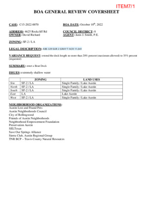
VARIANCE REQUEST: extend the dock length no more than 20% percent (maximum allowed) to 35% percent (requested) BOA GENERAL REVIEW COVERSHEET CASE: C15-2022-0070 BOA DATE: October 10th, 2022 ADDRESS: 4625 Rockcliff Rd OWNER: David Richard COUNCIL DISTRICT: 8 AGENT: Janis J. Smith, P.E. ZONING: SF-2 / LA LEGAL DESCRIPTION: ABS 329 SUR 2 GRAY T ACR 11.041 SUMMARY: erect a Boat Dock ISSUES: extremely shallow water ZONING LAND USES Site North South East West SF-2 / LA SF-2 / LA SF-2 / LA LA SF-2 / LA Single Family / Lake Austin Single Family / Lake Austin Single Family / Lake Austin Lake Austin Single Family / Lake Austin NEIGHBORHOOD ORGANIZATIONS: Austin Lost and Found Pets Austin Neighborhoods Council City of Rollingwood Friends of Austin Neighborhoods Neighborhood Empowerment Foundation Preservation Austin SELTexas Save Our Springs Alliance Sierra Club, Austin Regional Group TNR BCP – Travis County Natural Resources ITEM7/1 September 28, 2022 Janis Smith PE 1505 Westover Rd Austin, TX 78703 Re: C15-2022-0070 Dear Janis, Property Description: ABS 329 SUR 2 GRAY T ACR 11.041 Austin Energy (AE) has reviewed your application for the above referenced property, requesting that the Board of Adjustment consider a variance request from LDC Section 25-2-1176(A)(2) at 4625 Rockcliff Rd. Austin Energy does not oppose the request, provided that any proposed or existing improvements follow Austin Energy’s Clearance & Safety Criteria, the National Electric Safety Code, and OSHA requirements. Any removal or relocation of existing facilities will be at the owner’s/applicant’s expense. Please use this link to be advised of our clearance and safety requirements which are additional conditions of the above review action: https://library.municode.com/tx/austin/codes/utilities_criteria_manual?nodeId=S1AUENDECR_1 .10.0CLSARE If you require further information or have any questions regarding the above comments, please contact our office. Thank you for contacting Austin Energy. Cody Shook, Planner II Austin Energy Public Involvement | Real Estate Services 2500 Montopolis Drive Austin, TX 78741 (512) 322-6881 Cody.Shook@austinenergy.com ITEM7/2 Board of Adjustment General/Parking Variance Application DevelopmentATX.com | Phone: 311 (or 512-974-2000 outside Austin) For submittal and fee information, see austintexas.gov/digitaldevelopment WARNING: Filing of this appeal stops all affected construction activity. This application is a fillable PDF that can be completed electronically. To ensure your information is saved, click here to Save the form to your computer, then open your copy and continue. The Tab key may be used to navigate to each field; Shift + Tab moves to the previous field. The Enter key activates links, emails, and buttons. Use the Up & Down Arrow keys to scroll through drop-down lists and check boxes, and hit Enter to make a selection. The application must be complete and accurate prior to submittal. If more space is required, please complete Section 6 as needed. All information is required (if applicable). For Office Use Only Case # __________________ ROW # ___________________ Tax # ____________________ C15-2022-0070 0133110161 13009285 Section 1: Applicant Statement Street Address: __________________________________________________________________ 4625 Rockcliff Road Subdivision Legal Description: ABS 329 SUR 2 GRAY T ACR 11.0421 ____________________________________________________________________________ ____________________________________________________________________________ Lot(s): _________________________________ Block(s): _____________________________ Outlot: _________________________________ Division: _____________________________ Zoning District: ___________________________________________________________________ Council District: 8 SF-2 I/We ________________________________________________ on behalf of myself/ourselves as Janis J. Smith, P.E. authorized agent for ________________________________________________ affirm that on David and Ethel Richard Month August , Day 28 , Year 2022 , hereby apply for a hearing before the Board of Adjustment for consideration to (select appropriate option below): Erect Attach Complete Remodel Maintain Other: ____________ Type of Structure: ______________________________________________________________ Boat dock City of Austin | Board of Adjustment General/Parking Variance Application 6/26/20 | Page 4 of 8 ITEM7/3 Portion of the City of Austin Land Development Code applicant is seeking a variance from: 25-2-1176(A)(2) The length of a dock from the shoreline may not exceed 20% of the lake ____________________________________________________________________________ channel, as measured from the shoreline where the dock is located and continuing to the ____________________________________________________________________________ opposite shoreline. This application is for a dock extension of 35% of the channel width. ____________________________________________________________________________ ____________________________________________________________________________ Section 2: Variance Findings The Board must determine the existence of, sufficiency of, and weight of evidence supporting the findings described below. Therefore, you must complete each of the applicable Findings Statements as part of your application. Failure to do so may result in your application being rejected as incomplete. Please attach any additional supporting documents. NOTE: The Board cannot grant a variance that would provide the applicant with a special privilege not enjoyed by others similarly situated or potentially similarly situated. I contend that my entitlement to the requested variance is based on the following findings: Reasonable Use The zoning regulations applicable to the property do not allow for a reasonable use because: The site shoreline borders a cove that's extremely shallow. There's one access path within the ____________________________________________________________________________ cove that's deep enough to be navigable. The rest of the cove is less than 2' deep. So even if ____________________________________________________________________________ the owner were to dredge a navigable dock, a boat couldn't reach the slips unless the dock ____________________________________________________________________________ opens on the access path. Thus the location of the dock is set by the location of the navigable ____________________________________________________________________________ access path. And that dock location extends about 35% of the channel width. However, this site almost exclusively contains both shorelines of the channel. ____________________________________________________________________________ ____________________________________________________________________________ ____________________________________________________________________________ Hardship a) The hardship for which the variance is requested is unique to the property in that: The water is extremely shallow in this location, and the dock has to extend to the lone navigable ____________________________________________________________________________ access path in order to be used. ____________________________________________________________________________ ____________________________________________________________________________ ____________________________________________________________________________ ____________________________________________________________________________ b) The hardship is not general to the area in which the property is located because: The vast majority of dock sites on Lake Austin have sufficiently deep water to be permitted ____________________________________________________________________________ following code limitations. ____________________________________________________________________________ ____________________________________________________________________________ ____________________________________________________________________________ ____________________________________________________________________________ City of Austin | Board of Adjustment General/Parking Variance Application 6/26/20 | Page 5 of 8 ITEM7/4 Area Character The variance will not alter the character of the area adjacent to the property, will not impair the use of adjacent conforming property, and will not impair the purpose of the regulations of the zoning district in which the property is located because: Both shorelines of the channel are located on this property. There is a small section of ____________________________________________________________________________ shoreline off-property, but the dock construction won't prevent a boat from reaching that off-site ____________________________________________________________________________ shoreline. ____________________________________________________________________________ ____________________________________________________________________________ ____________________________________________________________________________ ____________________________________________________________________________ Parking (additional criteria for parking variances only) Request for a parking variance requires the Board to make additional findings. The Board may grant a variance to a regulation prescribed in the City of Austin Land Development Code Chapter 25-6, Appendix A with respect to the number of off-street parking spaces or loading facilities required if it makes findings of fact that the following additional circumstances also apply: 1. Neither present nor anticipated future traffic volumes generated by the use of the site or the uses of sites in the vicinity reasonably require strict or literal interpretation and enforcement of the specific regulation because: NA ____________________________________________________________________________ ____________________________________________________________________________ ____________________________________________________________________________ ____________________________________________________________________________ 2. The granting of this variance will not result in the parking or loading of vehicles on public streets in such a manner as to interfere with the free flow of traffic of the streets because: NA ____________________________________________________________________________ ____________________________________________________________________________ ____________________________________________________________________________ ____________________________________________________________________________ 3. The granting of this variance will not create a safety hazard or any other condition inconsistent with the objectives of this Ordinance because: NA ____________________________________________________________________________ ____________________________________________________________________________ ____________________________________________________________________________ ____________________________________________________________________________ 4. The variance will run with the use or uses to which it pertains and shall not run with the site because: NA ____________________________________________________________________________ ____________________________________________________________________________ ____________________________________________________________________________ ____________________________________________________________________________ City of Austin | Board of Adjustment General/Parking Variance Application 6/26/20 | Page 6 of 8 ITEM7/5 Section 3: Applicant Certificate I affirm that my statements contained in the complete application are true and correct to the best of my knowledge and belief. Applicant Signature: ____________________________________________ Date: _____________ 08/29/2022 Janis J. Smith Digitally signed by Janis J. Smith Date: 2022.08.29 07:34:57 -06'00' Applicant Name (typed or printed): ___________________________________________________ Janis J. Smith, P.E. Applicant Mailing Address: __________________________________________________________ 1505 Westover Road City: ________________________________________ State: ________________ Zip: _______ 78703 Austin Texas Phone (will be public information): ____________________________________________________ 512-914-3729 Email (optional – will be public information): ____________________________________________ Section 4: Owner Certificate I affirm that my statements contained in the complete application are true and correct to the best of my knowledge and belief. Owner Signature: ______________________________________________ Date: _____________ 08/29/2022 DavidRRichard DavidRRichard (Aug 30, 2022 09:16 CDT) Owner Name (typed or printed): ______________________________________________________ David Richard Owner Mailing Address: ____________________________________________________________ 4625 Rockcliff Road City: ________________________________________ State: ________________ Zip: _______ 78746 Austin TX Phone (will be public information): ____________________________________________________ 512-694-3513 Email (optional – will be public information): ____________________________________________ Section 5: Agent Information Agent Name: ____________________________________________________________________ Agent Mailing Address: ____________________________________________________________ City: ________________________________________ State: ________________ Zip: _______ Phone (will be public information): ____________________________________________________ Email (optional – will be public information): ____________________________________________ Section 6: Additional Space (if applicable) Please use the space below to provide additional information as needed. To ensure the information is referenced to the proper item, include the Section and Field names as well (continued on next page). _______________________________________________________________________________ _______________________________________________________________________________ _______________________________________________________________________________ _______________________________________________________________________________ City of Austin | Board of Adjustment General/Parking Variance Application 6/26/20 | Page 7 of 8 ITEM7/6 4625 BOA signed app Final Audit Report 2022-08-30 Created: 2022-08-29 By: Status: Janis Smith Signed Transaction ID: CBJCHBCAABAAZZoUzfG_2mW1V29T2fIQrq-_NEudgm-Y "4625 BOA signed app" History Document digitally presigned by Janis J. Smith (j 2022-08-29 - 1:34:57 PM GMT- IP address: 207.135.248.10 Document created by Janis Smith (j 2022-08-29 - 1:37:24 PM GMT- IP address: 207.135.248.10 Document emailed to 2022-08-29 - 1:38:23 PM GMT Email viewed by 2022-08-29 - 2:29:24 PM GMT- IP address: 104.28.123.113 Signer entered name at signing as DavidRRichard 2022-08-30 - 2:16:49 PM GMT- IP address: 72.194.218.116 Document e-signed by DavidRRichard Signature Date: 2022-08-30 - 2:16:50 PM GMT - Time Source: server- IP address: 72.194.218.116 Agreement completed. 2022-08-30 - 2:16:50 PM GMT ITEM7/7 Janis Smith Consulting, LLC Civil Engineering Consulting for Lake Austin Shoreline Projects September 17, 2022 Board of Adjustment P.O. Box 1088 Austin, Texas 78767 Dear Board Members: Re: Engineering Summary Letter for 4625 Rockcliff Road SP-2022-0246D Application for a variance to LDC 25-2-1176(A)(2) to allow construction of a boat dock extending 35% of the channel width. The project titled 4625 Rockcliff Road proposes to construct a two-slip boat dock and new bulkhead on an 11-acre site located about 2 miles north of the intersection of Loop 360 and Westlake Drive. It’s in the Limited Purpose Jurisdiction of the City of Austin on the shore of Lake Austin. A Site Plan application for this project is currently under review with City staff. The first set of City comments has been received, and an update was submitted in response. The proposed dock plan and elevation views are below. 1505 Westover Road ! Austin, Texas 78703 ! www.janissmithconsulting.com ! TBPE Firm No. F-16978 ITEM7/8 4625 Rockcliff Road BOA Variance Application 9/17/22 Page 2 of 3 This application is for a BOA variance to construct a dock extending more than 20% of the channel width. The dock design currently under review extends 35% of the channel width. The property fronts on both a Lake Austin slough as well as an unnamed creek. Please see pictures below. Lake Austin Slough and Approximate Dock Location Unnamed Creek Upstream of Lake Austin 1505 Westover Road ! Austin, Texas 78703 ! www.janissmithconsulting.com ! TBPE Firm No. F-16978 ITEM7/9 4625 Rockcliff Road BOA Variance Application 9/17/22 Page 3 of 3 There’s a single navigable channel in the slough that’s deep enough for a boat to travel. In order to get a boat from the lake to the proposed dock, the dock must access the navigable channel thus the boat dock location is dictated by the navigable channel. The shoreline layout is shown below. Per the FEMA map and COA Property Profile tool, Lake Austin ends just upstream of the proposed dock at which point the channel becomes an unnamed creek. The proposed dock extension won’t hamper access to the 42’ of the Lake Austin channel upstream of the proposed dock location. The proposed boat dock extension leaves a 62’ wide path open for watercraft to travel up the remaining 42’ of slough. However, the canal’s too shallow to be navigable for boats. On behalf of the owners, Ethel and Davd Richards, I ask you to support the variance application to allow them to permit a boat dock on their lakefront property in the only location that’s feasible. I look forward to the meeting on the 10th. Very truly yours, Janis J. Smith, P.E Janis Smith Consulting, LLC 512-914-3729 1505 Westover Road ! Austin, Texas 78703 ! www.janissmithconsulting.com ! TBPE Firm No. F-16978 ITEM7/10 4625 ROCKCLIFF ROAD TREE # CALIPER SIZE (IN) TREE TYPE PROPOSED TREE # CALIPER SIZE (IN) TREE TYPE PROPOSED TREE # CALIPER SIZE (IN) TREE TYPE PROPOSED TREE LIST TREE LIST TREE LIST 1 2 3 4 5 6 7 8 9 10 11 12 13 14 15 16 17 18 22.5 12.5 10.5 13 10 14 17 11 11 16 11 11 8 31 21 12 16 9 CEDAR ELM CEDAR ELM CEDAR CEDAR ELM CEDAR ELM LIVE OAK CEDAR ELM CEDAR ELM CEDAR CEDAR ELM CEDAR ELM LIVE OAK CEDAR ELM CEDAR ELM CEDAR CEDAR ELM CEDAR ELM LIVE OAK REMAINING REMAINING REMAINING REMAINING REMAINING REMAINING REMAINING REMAINING REMAINING REMAINING REMAINING REMAINING REMAINING REMAINING REMAINING REMAINING REMAINING REMAINING 19 20 21 22 23 24 25 26 27 28 29 30 31 33 34 35 36 37 26 17 13.5 10.5 9 8 11.5 25 6.5 6.5 10 11 19 14 8 11 10.5 13.25 CEDAR ELM CEDAR ELM CEDAR CEDAR ELM CEDAR ELM LIVE OAK CEDAR ELM CEDAR ELM CEDAR CEDAR ELM CEDAR ELM LIVE OAK CEDAR ELM CEDAR CEDAR ELM CEDAR ELM LIVE OAK CEDAR ELM REMAINING REMAINING REMAINING REMAINING REMAINING REMAINING REMAINING REMAINING REMAINING REMAINING REMAINING REMAINING REMAINING REMAINING REMAINING REMAINING REMAINING REMAINING 38 39 40 41 42 43 44 45 46 47 48 49 50 51 52 53 54 55 18.5 11.5 9 21 34 8 8.5 12 17 14 9 15 14 18.5 9.5 10.5 12 10.75 CEDAR ELM CEDAR CEDAR ELM CEDAR ELM LIVE OAK CEDAR ELM CEDAR ELM CEDAR CEDAR ELM CEDAR ELM LIVE OAK CEDAR ELM CEDAR ELM CEDAR CEDAR ELM CEDAR ELM LIVE OAK CEDAR ELM REMAINING REMAINING REMAINING REMAINING REMAINING REMAINING REMAINING REMAINING REMAINING REMAINING REMAINING REMAINING REMAINING REMAINING REMAINING REMAINING REMAINING REMAINING LINE L1 L2 L3 L4 L5 L6 L7 L8 L9 L10 L11 L12 L13 LINE TABLE BEARING N 84°39'10" E S 34°30'06" W S 34°30'06" W S 34°29'20" W N 60°11'00" W N 60°24'26" W N 32°06'01" E S 32°14'11" W N 32°14'11" E N 59°53'10" W N 29°43'59" E N 29°31'59" E N 64°51'58" E LENGTH 331.36' 454.72' 367.22' 632.94' 199.07' 4.75' 358.47' 763.18' 123.83' 195.90' 358.39' 412.08' 426.56' WETLAND CEF 4 PROPERTY BOUNDARY L12 L 1 0 L 6 L 5 L11 TRACT 1 SPRING CEF 1 TRACT BOUNDARY L7 RIMROCK CEF 1 WETLAND CEF 7 WETLAND CEF 5 TRACT 2 TRACT 3 WETLAND CEF 8 RIMROCK CEF 1 AND SPRING CEF 1 SETBACK WETLAND CEF 6 WETLAND CEF 2 TRACT BOUNDARY L8 4 9 4 5 0 0 75' CWQZ 4 9 2 4 9 1 C LO L 4 O 9 C 5 L O C 1 9 4 C O L 490 C O L 489 R C I P 1 / 2 490 L9 PROJECT LIMIT OF CONSTRUCTION SEE SHEET 3 FOR EXISTING CONDITIONS AND SHEET 4 FOR PROPOSED CONDITIONS DAVID R & ETHEL A RICHARD ABS 329 SUR 2 GRAY T ACR 11.041 DEED DOC. #2000017983TR ZONING: SF-2 USE: SF RESIDENCE 5 4 0 5 3 5 4 9 2 4 9 1 C O L WETLAND CEF 1 EXISTING SHORELINE ELEV = 492.8' 4 8 9 489 L A K E A U S T I N 490 L 1 C O L L O C C L O X WETLAND CEF 3 L 1 3 5 0 5 L O C / M L S O C / M S C O L L O C L O C / M S 5 3 0 5 2 5 520 X X L4 L3 5 1 5 X C A L C P T C A L C P T LOCATION OF CRITICAL ENVIRONMENTAL FEATURES ON ALL TRACTS OF THE PROPERTY 0 0 50 100 4 8 9 25 75 C A L C P T L2 C A L C P T LEGEND CEF CEF SETBACK EXISTING SHORELINE CWQZ SETBACK FEMA 100-YR FLOODPLAIN/BFE LOC LOC LIMIT OF CONSTRUCTION LOC/MS LOC/MS LIMIT OF CONSTRUCTION/MULCH SOCK EXISTING IMPERVIOUS COVER TREE # TREE CRITICAL ROOT ZONE ' D V P P A I N O S V E R I E T A D . O N 2 2 0 2 / 4 2 / 8 0 9 2 7 3 - 4 1 9 - 2 1 5 3 0 7 8 7 s a x e T , n i t s u A d a o R r e v o t s e W 5 0 5 1 8 7 9 6 1 - F r e b m u N n o i t a r t s i g e R s r e e n i g n E l a n o i s s e f o r P f o d r a o B s a x e T C L L , g n i t l u s n o C h t i m S s i n a J I D A O R F F L C K C O R 5 2 6 4 I D N A S N O T A C O L F E C I N A L P E T S L L A R E V O D 6 4 2 0 - 2 2 0 2 - P S - F F I L C K C O R 5 2 6 4 DESIGNED: JJS APPROVED: SCALE: AS SHOWN 4625 ROCKCLIFF ROAD DATE: MARCH 29, 2022 SHEET of 7 2 2 SP-2022-0246D ITEM7/11 NOTES: 1. ALL WORK SHALL OCCUR WITHIN THE LIMITS OF CONSTRUCTION AS SHOWN ON THE PLAN. ALL MATERIALS WILL BE TRANSPORTED TO THE SITE FROM WATER AND LAND. ALL CONSTRUCTION ACTIVITY, INCLUDING STAGING AND SPOIL STORAGE, WILL BE CONTAINED IN THE LIMIT OF CONSTRUCTION AND ON THE BARGE. 2. SHORELINE IMPROVEMENTS, INCLUDING GANGWAY ACCESS, ARE AUTHORIZED WITH THIS SITE PLAN. 3. CONTAINERS OF HAZARDOUS MATERIALS, FUEL, OIL, HERBICIDES, INSECTICIDES, FERTILIZERS, OR OTHER POLLUTANTS WILL NOT BE STORED ON DOCKS EXTENDING INTO OR ABOVE LAKE AUSTIN. 4. NO WATER OR WASTEWATER UTILITIES ARE PROPOSED WITH THIS DEVELOPMENT. 5. DOCK SHALL BE AT LEAST 66% OPEN. 6. PILINGS SHALL BE 6-5/8" DIAMETER STEEL PIPE. 7. THE PROJECT SITE IS WITHIN THE CITY OF AUSTIN LIMITED PURPOSE BOUNDARIES. DREDGE MATERIAL SHALL BE DISPOSED DRY IN A LEGALLY PERMITTED LANDFILL SITE. PRIOR TO OFFSITE DISPOSAL, THE PERMITTEE SHALL PROVIDE THE ENVIRONMENTAL INSPECTOR WITH THE ADDRESS AND CONTACT NUMBER FOR THE DISPOSAL SITE. DISPOSAL OF DREDGE SPOIL IN THE LAKE IS SPECIFICALLY PROHIBITED. NO SPOILS ARE ALLOWED WITHIN THE 100-YR FLOODPLAIN. DREDGING WILL BE LESS THAN 25 CU YDS. 8. 9. 10. 2 9 4 TOP OF RIPRAP = 494.8' EXISTING SHORELINE = PROPOSED SHORELINE WSEL = 492.8' 492' 496' 494' 490' ROCK RIPRAP MIN DIAM = 8" MAX SLOPE = 1:1 EXISTING LAKEBED BULKHEAD DETAIL LOC 731 C O L 506 504 502 500 498 496 494 492 0 LOC LOC 727 728 EXISTING PROFILE 6" MIN BEDDING MATERIAL NONUNIFORM, IRREGULARLY SHAPED STEPPING STONES BOAT DECK 10 20 30 40 ACCESS PATH DETAIL NOTE: THE PROPOSED BOAT DOCK MUST COMPLY WITH ALL REQUIREMENTS OF LDC 25-2-1174 (“STRUCTURAL REQUIREMENTS”), AND MUST COMPLY WITH CHAPTER 25-12, ARTICLE 1 (UNIFORM BUILDING CODE) AND THE BUILDING CRITERIA MANUAL. 4625 ROCKCLIFF ROAD PROPERTY BOUNDARY EXISTING SHORELINE LENGTH = 1047.6' ALLOWABLE DOCK WIDTH = 209.5' PROPOSED DOCK WIDTH = 36.8' PROPOSED DOCK DEPTH = 35.8' DOCK FOOTPRINT = 1200.0 SF ATTENTION INSPECTOR NOTES: 1. COMPLIANCE WITH BUILDING CODE REQUIRED AND IS TO BE REVIEWED 2. FOR COMPLIANCE DURING BUILDING CODE REVIEW. FOR THE BUILDING PERMIT, A SIGNED AND SEALED LETTER SHALL BE SUBMITTED TO THE CITY OF AUSTIN, PER THE LAND DEVELOPMENT CODE, 25-12-3 1612.4, CERTIFYING THAT THE STRUCTURE IS IN ACCORDANCE WITH ASCE 24, FLOOD RESISTANT DESIGN AND CONSTRUCTION. 3. ENVIRONMENTAL INSPECTOR HAS THE AUTHORITY TO ADD AND/OR MODIFY EROSION/SEDIMENTATION CONTROLS ON SITE TO KEEP PROJECT IN COMPLIANCE WITH THE CITY OF AUSTIN RULES AND REGULATIONS. C O L C O L C O L C O L L O C 730 729 LOC E G D E R D 2 C E S X LOC LOC 4 9 0 E G D E R D 1 C E S X L O C 492 4 9 1 L O C L O C L O C LOC L O C LOC C O L 748 L O C 737 493 494 495 496 497 498 499 500 501 LOCATIONS 100-YR FLOODPLAIN/BFE = 494.7' EXISTING PROFILE NOSE OF SLIP PROPOSED PROFILE WSEL = 492.8' DREDGE = 11.4 CY 10 20 30 DREDGE XSEC 1 40 50 100-YR FLOODPLAIN/BFE = 494.7' NOSE OF SLIP EXISTING PROFILE PROPOSED PROFILE WSEL = 492.8' L O C 747 488 0 506 504 502 500 498 496 494 492 490 506 504 502 500 498 496 494 492 490 488 0 LOC 7 4 7 C O F L S S X X L O C C O L F S S C O L F S S C O L F S S C O L FSS X X L O C L O C L O C L O C X X X X X X X X FEMA 100-YR FULLY DEVELOPED FLOODPLAIN ELEV = 494.7' 7 4 6 BEGIN BULKHEAD MODIFICATION INSTALL ROCK RIPRAP FROM ELEV. 491 TO ELEV 494.8' ALONG THE SHORELINE MIN DIAMETER OF RIPRAP IS 8" APPROX. 206.8 LF WETLAND CEF 3 75' CWQZ SETBACK P R O P E R T Y C O N T A I N S B O T H S H O R E L I N E S TRACT BOUNDARY WETLAND CEF 2 LOC FSS 28.8' LOC FSS LOC FSS LOC LOC F S S 4 9 2 FS S 4 9 1 C O L H T L W I D E E H N D R T O T N E A R H E U 5 . 3 ' C L I N S A 4 . 8 % A M E R L U E D I C H I S 3 N H E T N L C L W I D E P E K W I D R N N E A H E D O C C A H E C H O F T T T N N H E T 0 4 9 9 P C O L F S S C O L F S S FSS LOC 28.4' FSS LOC FSS LOC FSS LOC FSS LOC FSS LOC C O L INSTALL FLOATING SILT SCREEN APPROX. 313.8 LF 4 9 0 F S S C O L F S S C O L 4 9 1 4 8 9 PROPOSED 36.1' X 36.8' DOCK SEE DOCK PLAN AND ELEVATION VIEWS ON SHEETS 6 AND 7 PROPOSED DREDGE = 24.6 CY SEE DREDGE XSECS THIS SHEET SEE SHEET 5 FOR MITIGATION PLANTING PLAN 7 4 0 7 3 9 LIMIT OF CONSTRUCTION/MULCH SOCK APPROX. 176.1 LF INSTALL TREE PROTECTION FENCING APPROX. 101.0 LF 7 4 9 7 4 8 LOC/MS 5 0 5 XX X X LOC/MS 3 0 25 0 5 X X 1 0 5 L O 4 0 5 C / X X M S LOC X X L O C X X 7 3 7 LOC/MS XX 7 9 4 8 9 4 0 0 5 9 9 4 6 9 4 5 9 4 4 9 4 ' 8 . 6 3 3 9 4 BOAT DOCK ACCESS DURING CONSTRUCTION, THE PATH WILL BE USED AS A HAUL ROUTE. THE STONE PATH WILL BE INSTALLED IN THE FINAL STAGE OF CONSTRUCTION SEE ACCESS PATH DETAIL THIS SHEET X X 7 3 6 7 4 4 7 4 3 7 3 5 INSTALL TREE PROTECTION FENCING APPROX. 206.0 LF X X 7 3 8 X X L O C / M S / LIMIT OF CONSTRUCTION/MULCH SOCK APPROX. 136.5 LF X X L O C M S / L O C M S / X X X X L O C M S X X 36.1' 28.4' 3 . 2 ' 3 / L O C M S X X X X L O C M S / L O C M S / X X L O X C X M S / X X L O C M S / X X LOC/MS XX TREE 1 2 CRZ 7 2 5 INSTALL TREE PROTECTION FENCING APPROX. 40.3 LF 7 3 4 L O C M S / TREE CRZ 7 3 3 7 3 2 7 2 4 7 2 6 INSTALL TREE PROTECTION FENCING APPROX. 24.8 LF L O C M S / L O C M S / L O C M S / X L X O C/M S 7 1 2 7 2 3 7 2 1 7 2 0 X X L O C X X L O C L X O X C / M S L O C / M S X X L O C X / M X S XX LOC/MS 7 1 8 7 1 9 EXISTING LANDSCAPE WALL X TO REMAIN X TEMPORARY STAGING AND SPOILS STORAGE AREA / L O C M S X X L O C M S / X X L O C/M S X X L O X C/M X S X LO X C X X 7 0 4 INSTALL TREE PROTECTION FENCING APPROX. 42.8 LF 7 1 7 END BULKHEAD MODIFICATION X X L O C X X L O C 7 2 2 7 5 0 XX 7 2 9 7 3 0 X X L O C X X L O C X X 7 2 8 7 2 7 L O C X X L O C 7 3 1 F S S C O L F S S C O L C O L F S S L O C L O C L O C L O C C O L F S S C O L F S S C O L F S S C O L F S S C O L L O X C X L O C X X F S S C O L F S S C O L F S S C O L F S S C O L F S S C O L FS S C O L 7 1 0 7 1 1 X X INSTALL TREE PROTECTION FENCING APPROX. 61.6 LF LIMIT OF CONSTRUCTION/MULCH SOCK APPROX. 88.4 LF 7 1 6 L O C X X L O C EXISTING = PROPOSED SHORELINE ELEV = 492.8' LIMITS OF CONSTRUCTION LOC LOC 7 1 3 PROPOSED CONDITIONS X L X O C M S / LOC/MS X X LOC/MS LOC/MS PROPOSED BULKHEAD MODIFICATION 492 WETLAND CEF 1 INSTALL TREE PROTECTION FENCING APPROX. 20.7 LF INSTALL EROSION CONTROL MATTING 00 10 20 5 15 XX FSS LOC LOC/MS LEGEND EXISTING SHORELINE PROPOSED BULKHEAD MODIFICATION LA SETBACK FEMA 100-YR FLOODPLAIN/BFE TREE PROTECTION FLOATING SILT SCREEN LIMIT OF CONSTRUCTION LIMIT OF CONSTRUCTION/MULCH SOCK EXISTING WETLAND CEF PROPOSED DOCK EROSION CONTROL MATTING TREE # TREE CRITICAL ROOT ZONE, 1 AND 1 4 CRZ 2 CRZ, DREDGE = 13.2 CY 10 20 DREDGE XSEC 2 50 60 30 DREDGE QUANTITIES 1" = 10' 40 DREDGE XSECS FLOATING SILT SCREEN ' D V P P A I N O S V E R I E T A D . O N / 2 2 0 2 4 2 8 0 / 9 2 7 3 - 4 1 9 - 2 1 5 3 0 7 8 7 s a x e T , n i t s u A d a o R r e v o t s e W 5 0 5 1 8 7 9 6 1 - F r e b m u N n o i t a r t s i g e R s r e e n i g n E l a n o i s s e f o r P f o d r a o B s a x e T C L L , g n i t l u s n o C h t i m S s i n a J D A O R F F I L C K C O R 5 2 6 4 I I I N A L P E T S S N O T D N O C D E S O P O R P D 6 4 2 0 - 2 2 0 2 - P S - F F I L C K C O R 5 2 6 4 DESIGNED: JJS APPROVED: SCALE: AS SHOWN 4625 ROCKCLIFF ROAD DATE: MARCH 29, 2022 SHEET of 7 4 4 SP-2022-0246D ITEM7/12