A-1 C15-2022-0051 ADV PACKET INTERPRETATION — original pdf
Backup
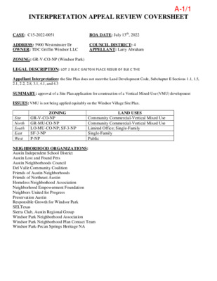
INTERPRETATION APPEAL REVIEW COVERSHEET CASE: C15-2022-0051 BOA DATE: July 13th, 2022 ADDRESS: 5900 Westminster Dr OWNER: TDC Griffin Windsor LLC COUNCIL DISTRICT: 4 APPELLANT: Larry Abraham ZONING: GR-V-CO-NP (Windsor Park) LEGAL DESCRIPTION: LOT 2 BLK C GASTON PLACE RESUB OF BLK C THE Appellant Interpretation: the Site Plan does not meet the Land Development Code, Subchapter E Sections 1.1, 1.5, 2.1, 2.2, 2.8, 3.1, 4.1, and 4.3 SUMMARY: approval of a Site Plan application for construction of a Vertical Mixed-Use (VMU) development ISSUES: VMU is not being applied equitably on the Windsor Village Site Plan. ZONING LAND USES GR-V-CO-NP Site North GR-MU-CO-NP South LO-MU-CO-NP; SF-3-NP East West SF-3-NP P-NP Community Commercial-Vertical Mixed Use Community Commercial-Vertical Mixed Use Limited Office; Single-Family Single-Family Public NEIGHBORHOOD ORGANIZATIONS: Austin Independent School District Austin Lost and Found Pets Austin Neighborhoods Council Del Valle Community Coalition Friends of Austin Neighborhoods Friends of Northeast Austin Homeless Neighborhood Association Neighborhood Empowerment Foundation Neighbors United for Progress Preservation Austin Responsible Growth for Windsor Park SELTexas Sierra Club, Austin Regional Group Windsor Park Neighborhood Association Windsor Park Neighborhood Plan Contact Team Windsor Park-Pecan Springs Heritage NA A-1/1 CITY OF AUSTIN Development Services Department One Texas Center | Phone: 512.978.4000 505 Barton Springs Road, Austin, Texas 78704 Board of Adjustment Interpretations Application Appeal of an Administrative Decision AMENDED This application is a fillable PDF that can be completed electronically. To ensure your information is saved, click here to Save the form to your computer, then open your copy and continue. The Tab key may be used to navigate to each field; Shift + Tab moves to the previous field. The Enter key activates links, emails, and buttons. Use the Up & Down Arrow keys to scroll through drop-down lists and check boxes, and hit Enter to make a selection. The application must be complete and accurate prior to submittal. If more space is required, please complete Section 6 as needed. All information is required (if applicable). For Office Use Only Case # __________________ ROW # ___________________ Tax # ____________________ C15-2022-0051 12938545 0222170914 Section 1: Applicant Statement Street Address: __________________________________________________________________ Subdivision Legal Description: ____________________________________________________________________________ ____________________________________________________________________________ Lot(s): _________________________________ Block(s): _____________________________ Outlot: _________________________________ Division: _____________________________ Zoning District: ___________________________________________________________________ I/We ________________________________________________ on behalf of myself/ourselves as authorized agent for ________________________________________________ affirm that on Month , Day , Year , hereby apply for an interpretation hearing before the Board of Adjustment. City of Austin | Board of Adjustment Interpretations Application 09/11/2015 | Page 2 of (cid:24) A-1/2 Development Services Department interpretation is: ____________________________________________________________________________ ____________________________________________________________________________ ____________________________________________________________________________ ____________________________________________________________________________ I feel the correct interpretation is: ____________________________________________________________________________ ____________________________________________________________________________ ____________________________________________________________________________ ____________________________________________________________________________ Section 2: Findings The Board must determine the existence of, sufficiency of and weight of evidence supporting the findings described below. Therefore, you must complete each of the applicable findings statements as part of your application. Failure to do so may result in your application being rejected as incomplete. Please attach any additional supporting documents. 1. There is a reasonable doubt of difference of interpretation as to the specific intent of the regulations or map in that: ____________________________________________________________________________ ____________________________________________________________________________ ____________________________________________________________________________ ____________________________________________________________________________ ____________________________________________________________________________ 2. An appeal of use provisions could clearly permit a use which is in character with the uses enumerated for the various zones and with the objectives of the zone in question because: ____________________________________________________________________________ ____________________________________________________________________________ ____________________________________________________________________________ ____________________________________________________________________________ ____________________________________________________________________________ 3. The interpretation will not grant a special privilege to one property inconsistent with other properties or uses similarly situated in that: ____________________________________________________________________________ ____________________________________________________________________________ ____________________________________________________________________________ ____________________________________________________________________________ ____________________________________________________________________________ City of Austin | Board of Adjustment Interpretations Application 09/11/2015 | Page 3 of (cid:24) Site Plan Permit Case#: 2020-093520 SPReference File Name: SP-2020-0757C.SH Description: The applicant is proposing residential building and garage/carport parking with associated improvements.Approved and Released May 2, 2022.The Windsor Village Consolidated Site Plan does not meet the Austin, Texas Code of Ordinances, Title 25 - Land Development; Subchapter E: § 1.1 General Intent of General Provisions, § 1.5 Alternative Equivalent Compliance, § 2.1 Intent of Site Development Standards, § 2.2 Relationship of Buildings to Streets and Walkways § 2.8 Shade and Shelter, § 3.1 Intent of Building Design Standards, § 4.1 Intent of Mixed Use, and § 4.3. Vertical Mixed Use Buildings.not convenient to nor easily accessible from the roadside pedestrian and bicycle system (§ 2.1.7). This is a large site that is not developed in a manner that supports and encourages connectivity (§ 2.1.10). The site plan does not ensure that buildings contribute to the creation of a pedestrian-friendly environment through the provision of glazing, shading, and shelter at the pedestrian level (§ 3.1.3), nor does it offer a balanced & sustainable mix of use, nor promote an efficient pedestrian-access network that connects the nonresidential and residential uses and transit facilities. (§ 4.1)The site is zoned GR-V-CO-NP. The site plan misapplies the optional VMU zoning to construct a multi-family project on a commercially zoned lot. The site plan must comply with all VMU requirements or apply for a zoning change.VMU is not being applied equitably on the Windsor Village site plan, compared to other projects cited by the City review staff : (frontages estimated using Google Earth)The site plan fails to meet many of the Subchapter E goals: It does not relate well to adjoining public streets, open spaces or the neighborhood as outlined (§ 1.1.5). Building entranceways are6701 Burnet Road The Marq 36 square feet 90% of 575-foot frontage1620 E. Riverside AMLI South Shore 21 square feet 85% of 500-foor frontage3715 S. First St. Tree Apartments 18 sqiare feet57% of 250-foot frontage5900 Westminster Windsor Village 7 square feet0% of 440-foot frontage on ICRAddress Project Name Commercial Space/Unit % Commercial on Street FrontageA-1/3 Section 3: Applicant/Aggrieved Party Certificate I affirm that my statements contained in the complete application are true and correct to the best of my knowledge and belief. Applicant Signature: ____________________________________________ Date: _____________ Applicant Name (typed or printed): ___________________________________________________ Applicant Mailing Address: __________________________________________________________ City: ________________________________________ State: ________________ Zip: _______ Phone (will be public information): ____________________________________________________ Email (optional – will be public information): _____________________ Section 4: Owner Information Owner Name: ____________________________________________________________________ Owner Mailing Address: ____________________________________________________________ City: ________________________________________ State: ________________ Zip: _______ Section 5: Agent Information Agent Name: ____________________________________________________________________ Agent Mailing Address: ____________________________________________________________ City: ________________________________________ State: ________________ Zip: _______ Phone (will be public information): ____________________________________________________ Email (optional – will be public information): ___________________________ Section 6: Additional Space (if applicable) Please use the space below to provide additional information as needed. To ensure the information is referenced to the proper item, include the Section and Field names as well (continued on next page). _______________________________________________________________________________ _______________________________________________________________________________ _______________________________________________________________________________ _______________________________________________________________________________ _______________________________________________________________________________ _______________________________________________________________________________ _______________________________________________________________________________ _______________________________________________________________________________ _______________________________________________________________________________ _______________________________________________________________________________ City of Austin | Board of Adjustment Interpretations Application 09/11/2015 | Page 4 of 5 ATTACHMENTS 1. Property Owner Representative (Letter)2.Agent: Pro Bono Consultant (Letter) 3. Location Eligibility (Copy Of City Staff Email) 4. Reference PlansA.C100 Existing Conditions & Demolition Plan B. C200 Overall Site Layout C. Backup Documentation 5. Windsor Village Compliance Concerns Narrative 6. Approved Civil Plans with Concerns Notated: C000, C001, C002, C200, C201, C202 R A011, A0197.Engineers Summary Letter 8. Site Plan Permit Approval Letter 9. Windsor Park Neighborhood Association Letter of Support10.Windsor Park Neighborhood Plan Contact Team Letter of SupportFurther documentation can be provided as allowed.A-1/4 Additional Space (continued) _______________________________________________________________________________ _______________________________________________________________________________ _______________________________________________________________________________ _______________________________________________________________________________ _______________________________________________________________________________ _______________________________________________________________________________ _______________________________________________________________________________ _______________________________________________________________________________ _______________________________________________________________________________ _______________________________________________________________________________ _______________________________________________________________________________ _______________________________________________________________________________ _______________________________________________________________________________ _______________________________________________________________________________ _______________________________________________________________________________ _______________________________________________________________________________ _______________________________________________________________________________ _______________________________________________________________________________ _______________________________________________________________________________ _______________________________________________________________________________ _______________________________________________________________________________ _______________________________________________________________________________ _______________________________________________________________________________ _______________________________________________________________________________ _______________________________________________________________________________ _______________________________________________________________________________ _______________________________________________________________________________ _______________________________________________________________________________ _______________________________________________________________________________ _______________________________________________________________________________ _______________________________________________________________________________ _______________________________________________________________________________ _______________________________________________________________________________ _______________________________________________________________________________ _______________________________________________________________________________ _______________________________________________________________________________ _______________________________________________________________________________ _______________________________________________________________________________ City of Austin | Board of Adjustment Interpretations Application 09/11/2015 | Page 5 of 5 WINDSOR VILLAGE No. SP-2020-0257C.SH APPEAL SUMMARY May 18, 2022 1. In order for a property owner/applicant to receive approval for a building permit in the City of Austin for commercial and/or multi-family new construction, the City staff must approve site plans and building plans. 2. In order to receive approval, an applicant must demonstrate compliance with zoning,subdivision, site plan, building code, and other applicable regulations. 3. This site plan application, as initially filed and subsequently revised, does not comply withportions of Subchapter E of the Zoning Code, including: § 1.1 General Intent of the General Provisions § 2.1 Intent of Site Development Standards § 2.2 Relationship of Building to Streets and Walkways § 2.8 Shade and Shelter § 3.1 Intent of Building Design Standards § 4.1 Intent of Mixed Use § 4.3 Vertical Mixed Use Buildings 4. § 2.2 Relationship of Building to Streets and Walkways requires: a) An Internal Circulation Route (ICR) is the highest priority roadway type in the site plan, and therefore considered the principal street of the development. b) Buildings must be oriented along an Internal Circulation Route with the majority of tenant spaces facing the ICR. c) Building entrances should be located along the elevation facing the principal street. 5. § 2.8 Shade and Shelter requires: shaded sidewalks along 50% of the building frontage on the designated Internal Circulation Route. 6. § 4.3 Vertical Mixed Use Buildings requirements: a) The building must be designed for commercial uses in ground-floor spaces along at least 75% of the building frontage facing the principal street. b) A mix of uses, where a use on the ground floor must be different from a use on an upper floor. 7. If an applicant voluntarily chooses to develop under Vertical Mixed Use regulations adopted by the City Council, the applicant is required to meet with the Director and/or his/her designee, prior to submitting site plans and/or building plans per § 4.3.38.A Project Circulation Plan depicting Internal Circulation Routes must be submitted with a siteplan application for an area of 5 acres or larger per § 2.2.5.D 9. Based on information provided by City staff to date, the applicant for the site plan did not meet with the Director prior to submittal, nor provide a Project Circulation Plan.10. Based on information provided by City staff to date, the site plan was approved on May 2, 2022 without complying with the code sections listed in item 3 and § 1.5 Alternative Equivalent Compliance.11. The appellant requests that the Board of Adjustment reverse the City staff decision to approve the site plan and requests that the Director and/or their designee schedule a meeting with the applicant to outline all applicable zoning, subdivision, site plan, building code and other applicable regulations.Denial of this appeal could result in an appeal of the Validity of Permit provisions of the adopted 2021 International Building Code Section 105.4 if a building permit is issued based upon the May 2, 2022 site plan approval.A-1/5 ATTACHMENTS I. PROPERTY OWNER REPRESENTATIVE (LETTER) II. AGENT: PRO BONO CONSULTANT (LETTER) III. LOCATION ELIGIBILITY (COPY OF CITY STAFF EMAIL) IV. REFERENCE PLANS A. C100 EXISTING CONDITIONS & DEMOLITION PLAN B. C200 OVERALL SITE LAYOUT V. WINDSOR VILLAGE COMPLIANCE CONCERNS NARRATIVE VI. APPROVED CIVIL PLANS WITH CONCERNS NOTATED: C000, C001, C002, C200, C201, C202 R A011, A019 VII. ENGINEERS SUMMARY LETTERVIII. SITE PLAN PERMIT APPROVAL LETTER IX. WINDSOR PARK NEIGHBORHOOD ASSOCIATION LETTER OF SUPPORT X. WINDSOR PARK NEIGHBORHOOD PLAN CONTACT TEAM LETTER OF SUPPORTXI. AMENDMENTS A. SITE PLAN APPROVAL LETTER B. APPELLANT LETTER C. EXCERPTS FROM THE UNIVERSITY HILLS/WINDSOR PARK NEIGHBORHOOD PLANA-1/6 I. PROPERTY OWNER REPRESENTATIVE (LETTER) A-1/7 A-1/8 II. AGENT: PRO BONO CONSULTANT (LETTER) A-1/9 A-1/10 III. LOCATION ELIGIBILITY (COPY OF CITY STAFF EMAIL) A-1/11 5/17/22, 9:02 PM windsor park neighborhood association Mail - Appeal of Site Plan Permit Case# 2020-093520 SP Jackie Brooks > Appeal of Site Plan Permit Case# 2020-093520 SP Lloyd, Brent <brent.lloyd@austintexas.gov> To: RICK KRIVONIAK Cc: Larry Abraham <l < < , Lane Hicks >, "Garwood, Lyndi" , "Ramirez, Elaine" <Elaine.Ramirez@austintexas.gov> , Jackie Livelli Brooks , Hector Martell < > Mon, May 16, 2022 at 3:40 PM , rodney ahart >, shersh HPD staff confirmed that the property at 5801 Westminster Drive is within 200 feet of the site plan at issue, which is located at 5811 Berkman. The decision would ultimately be the BOA's, and we do not know the applicant's position in regards to this issue. From our perspective, however, the church property appears to satisfy the distance requirement. [Quoted text hidden] https://mail.google.com/mail/u/4/?ik=9f5a16fe80&view=pt&search=all&permmsgid=msg-f%3A1733016807005513787&simpl=msg-f%3A17330168070… 1/1 A-1/12 IV. REFERENCE PLANS A. C100 EXISTING CONDITIONS & DEMOLITION PLAN B. C200 OVERALL SITE LAYOUT A-1/13 Austin Mennonite Church 5801 Westminster Dr. A-1/14 Austin Mennonite Church 5801 Westminster Dr. A-1/15 V. WINDSOR VILLAGE COMPLIANCE CONCERNS NARRATIVE A-1/16 WINDSOR VILLAGE SITE PLAN COMPLIANCE CONCERNS I. SITE AREA CALCULATIONS The developer owns the 12.36-acre parcel at 5900 Westminster Dr., and intends to develop 11 +/- acres in the immediate future. The site area for the site plan application of the southern portion of the parcel has fluctuated in the various site plan submissions. The City’s opinion of the site area has also changed through the review process, excluding the parkland dedication area initially, then ultimately including the parkland dedication area, and determining that the site area is greater than 5 acres. The initial Windsor Village site plan submittal development size was greater than 5 acres. The area was reduced on the subsequent updates by subtracting the park area from the site area, which was prompted following the advice of City Staff per comments in review responses for Update 0. Summary of those changes are as follows: Submission Site Area excluding parkland (acres) Site Area including parkland (acres) Site Area as reviewed by City Staff (acres) Not provided 6.56** U0 U1 U2 U3 U4 U5 U6 (approved) 4.98 4.99 5.00 4.97 4.97 4.97 6.24 6.24 6.25 6.25 6.22* 6.22* 6.56 4.98 4.99 6.25 6.22 6.22 4.99*** *Calculation was not provided on site plan submittals, but was calculated with the areas provided in the submittal. **Site plan included development of Lot 2 (0.35 acres), which was submitted under a separate site plan. It is unclear if the parkland is included in this area provided on the site plan. ***U3 comments reflected City Staff’s acceptance of a site area less than 5 acres and did not revisit cleared comments associated with the site area being 5 acres or greater. Reopening cleared comments was done by City Staff at the insistence of the Windsor Village Working Group. Land Development Code (LDC) 25-1-21 - DEFINITIONS (47) GROSS SITE AREA means the total site area (105) SITE means a contiguous area intended for development, or the area on which a building has been proposed to be built or has been built. A site may not cross a public street or right-of-way. LDC definitions do not specifically allow for parkland to be excluded from site area calculations. The developer proposes an additional 345 units on land to the north, not currently under review, as well as the development of Lot 4 as commercial use. The developer has subdivided the site in what appears to be an attempt to skirt requirements for sites greater than 5 acres. A-1/17 U0 project response letter to Ann DeSanctis (Feb 1, 2021) included responses to comments requiring ICR with “Per our meeting with COA case manager and staff on October 26, 2020, we are no longer required to provide an ICR for this development, as our total lot size has been reduced to be < 5AC. Per our new site plan layout, facade of buildings along the Principal Roadway (Westminster Dr) will be built up to the supplemental zone.” It was later confirmed in the U5 report per staff consensus that an ICR is required for this site “Though the Parkland dedication reduces the overall site size to below 5 acres, it is staff consensus that the gross site area and applicable standards are determined by pre-dedication site size. As such, the applicable standards are internal circulation routes. In order to achieve project goals, Alternative Equivalent Compliance can be sought…” ➔ By excluding the parkland area calculations in early submissions, the project was exempted from the requirements for developments 5 acres or greater. The result is that the large site requirements are ‘shoehorned’ into the development to the detriment of the design as a whole. See annotated sheet C200 ➔ The exemption from large site requirements provided by the City early in the project review was corrected in the U5 comment report. This early mis-interpretation resulted in leniency in large site requirements, including Internal Circulation Route (ICR) requirements. II. INTERNAL CIRCULATION ROUTE LDC 25-2 Zoning, Subchapter E.2.2.5 A & B state the following: B. Internal Circulation Route. An Internal Circulation Route that establishes blocks and forms an interconnected, grid-like transportation system must be provided for development subject to this section. (See Figure 29.) An Internal Circulation Route must comply with the requirements of this subsection and should provide a safe and enjoyable walking environment overlooked by buildings that offer natural surveillance and contact from their occupants/users. A-1/18 ➔ The Windsor Village Development is 5 acres, designed with the principal street frontage on an Urban Roadway (Westminster) and does not provide an Internal Circulation Route as intended and defined by the Code. ➔ The proposed drive does not meet the intent or definition of an Internal Circulation Route. It does not offer connectivity, is not overlooked by buildings and has no surveillance or contact from building occupants. The proposed drive is primarily lined by enclosed single-vehicle parking garages and is not grid-like. III. PRINCIPAL STREET IN CONFLICT WITH CODE DEFINITION Article 5 of Subchapter E states: In this Subchapter, the principal street of a lot or site is the street with the highest priority that is adjacent to the lot or site. Street priorities are as follows from highest to lowest: Internal Circulation Route; ● Core Transit Corridor; ● ● Urban Roadway; ● ● HIghway or Hill Country Roadway Suburban Roadway; and Internal Circulation Route; ● Core Transit Corridor; ● ● Urban Roadway; ● ● HIghway or Hill Country Roadway Suburban Roadway; and Article 2.2.1. Overview of Roadway Types in Subchapter E states: A. Purpose. In this Subchapter, roadway types are used as an organizing tool for certain development standards. In this Section 2.2., sidewalk, building placement and streetscape standards and building entryway location are determined by the roadway type that is adjacent to the site. The following five roadway types are listed from the highest to lowest priority for the purposes of this Subchapter: B. Applicability. The roadway with the highest level of priority adjacent to the lot or site is considered the “principal street'' for purposes of this Subchapter. …. For large sites subject to Section 2.2.5 or for sites abutting more than one roadway type, the Sidewalk and Supplemental Zone requirements (but not he Building Placement and Parking requirements) shall apply along all abutting streets or Internal Circulation Route frontages, with the applicable requirements determined by the roadway type. The approved Site Plan Cover Sheet C000 states that the Principal Roadway Type is Westminster Drive, which is an Urban Roadway. ➔ The Internal Circulation Route (ICR) is a higher street priority than an Urban Roadway. Therefore the principal street is the Internal Circulation Route. ICR in the approved site plan does not comply with requirements of a principal street for site development or VMU development. A-1/19 IV. PROPOSED DEVELOPMENT EXCEEDS MAXIMUM BLOCK AREA FOR LARGE SITES LDC 25-2 Zoning, Subchapter E 2.2.5.C. Block Standards. 1. Maximum Block Size. Unless exempted by this subsection, a site shall be divided into internal blocks no larger than 5 acres. The maximum length of any block face, as measured from intersection to intersection, shall be 800 feet. No exemptions in this paragraph apply and the following Fig 29 (http://www.municode.com/webcontent/MunicodeNEXT/15303/25-2Fig29.png) is provided: The block area north and west of the proposed ICR, including Lot 1 (Hank’s), Lot 2 (permitted commercial development), is about 6 acres, exceeding the 5 acres maximum block area requirement. ➔ The approved ICR placement yields a block area greater than 5 acres. ICR should be located to divide blocks into less than 5 acres as intended by the Code. See annotated sheet C200 V. PROJECT CIRCULATION PLAN REQUIREMENT LDC 25-2 Zoning, Subchapter E 2.2.5.D 1. Plan Requirements. a. b. A Project Circulation Plan depicting Internal Circulation Routes required by this section must be submitted with a site plan application for an area of 5 acres or larger. b.The Project Circulation Plan must demonstrate that the project: (i) meets the applicable requirements of this section and Section 2.3 (Connectivity) of this Subchapter; (ii) integrates with existing and planned streets, bicycle and pedestrian facilities, and trails in the surrounding area; and (iii) is consistent with area mobility goals, as contained in the Transportation Plan or an approved collector plan. 2. Director Approval. a. b. A Project Circulation Plan must be reviewed and approved by the director under the requirements of this section. The Director may approve a Project Circulation Plan containing blocks bounded by railroad right-of-way, subdivision boundary lines, or natural features if no reasonable alternatives are available. A-1/20 c. d. Revisions to the Project Circulation Plan may be approved by the Director after considering the circulation characteristics of a proposed development plan, the need for access to adjoining properties, and the compatibility of surrounding development. The Director may waive the requirement for a Project Circulation Plan if the Director finds that a plan is not necessary due to the nature of the proposed development on the site, the existence of surrounding incompatible development, or other factors unique to the property which make strict compliance infeasible. ➔ Windsor Village is greater than 5 acres in area and a Project Circulation Plan has not been provided in the submissions for review or Director approval, nor has an exemption been granted and documented. ➔ Windsor Village should be designed and reviewed as a whole, including the north lot(s) that are slated to be developed by the same developer in the future. Dividing the site and not considering future design phases has reduced the developability of the northern lots. ➔ Had the Project Circulation Plan requirement been enforced and evaluated by City Staff, the ICR would have likely been placed in a location that would integrate with existing circulation patterns and would not have had to use alternative equivalent compliance. VI. SIDEWALK REQUIREMENTS LDC 25-2 Zoning, Subchapter E 2.2.5.E a. Publicly accessible sidewalks shall be provided along both sides of all Internal Circulation Routes (whether built as public streets or as private drives) unless: (i) no buildable area exists on one side. b. On portions of the Internal Circulation Route with building frontage the sidewalks and supplemental zones shall: (i) comply with the applicable standards for Urban Roadways, as provided in Section 2.2.3 (Urban Roadways: Sidewalk and Building Placement), and (ii) The planting zone shall be planted with street trees at an average spacing not greater than 30 feet on center. (See Figure 30.) c. On portions of the Internal Circulation Route that do not contain building frontage a five-foot unobstructed sidewalk shall be provided, all of which shall be located within 12 feet of the curb. (See Figure 30.) ➔ Windsor Village does not have publicly accessible sidewalks on both sides of an Internal Circulation Route. Sidewalks along the ICR are only provided on one side on the north-south portion of the drive and no sidewalks are provided on the east-west portion of the drive. ➔ Although a crosswalk is provided across the ICR, sidewalks on the north-south portion of the ICR is interrupted by the ICR itself and does not form a contiguous, uninterrupted path of travel for pedestrians through the site. The site plan cover page C000 includes the following Alternative Equivalent Compliance (AEC) notes: 1. Along the north-south section of the ICR, a publicly accessible sidewalk and planting zone has been provided along the entire western frontage. The east side of the ICR does not include walkways because of Building C’s garage entrances. The orientation of Building C was mirrored to address community input to provide the building frontage along the public park. Mirroring Building C allowed for the implementation of desired live/work units along the park, allowed for the removal of the rear drive aisle to the garages, and thereby increased the size of the parkland dedication. The park development plans allow for north-south public pedestrian movement east of the ICR and Building C. A-1/21 2. Along the west-east section of ICR, publicly accessible sidewalks and planting zones have not been provided adjacent to the ICR because of Building B’s garage entrances on the north side, and because of site constructions to the south. In place of sidewalks being developed directly adjacent to the ICR, publicly accessible sidewalks have been implemented along an 8’ public park trail that extends from Westminster to Berkman. The rail will be placed between existing preserved heritage trees and new plantings. ➔ Utilizing pedestrian walkways in the parkland areas to comply with ICR requirements reduces the area in the parkland for other recreational uses. ➔ Separating the 8’ park trail from an ICR deactivates the ICR, reducing surveillance on the sidewalk, creating safety concerns for park trail users. ➔ Community input referenced in the AEC statement was provided when the City Staff was not requiring an ICR, and should be irrelevant in the evaluation and acceptance of AEC. Including community input in the documents gives the false impression that the developer was interested in or took community input to heart. The developer was generally dismissive of community concerns and input. VII. BUILDING PLACEMENT 2.2.5. F. Building Placement. 1. Orientation of Building Frontage. Except as otherwise provided in this Section each building must be oriented along either an Internal Circulation Route or the adjacent public roadway of the highest priority. Each building must meet the building placement standards of the roadway to which it is oriented. 2. Building Placement Along Internal Circulation Route. The following standards apply where required building frontage is provided along an Internal Circulation Route: b. On a site with more than one principal building i. ii. The longer side of any building, any portion of which is within 100 feet of the Internal Circulation Route, must be built up to the clear zone (or supplemental zone if provided, or At least one side of any building, any portion of which is within 100 feet of the Internal Circulation Route, must be built up to the clear zone (or supplemental zone if provided) and the majority of the tenant spaces must have principal entrances facing the Internal Circulation Route. ➔ The long side of Building A is not built up to the ICR clear/supplemental zone. The portion of Building A built along the ICR does not have the majority of tenant spaces facing the ICR. Fenced residential porches face the ICR. Tenant spaces face Westminster, not the ICR, as required. ➔ The long side of Building B is oriented to the paseo, which is not presented as AEC for the ICR Sidewalk requirements and does not offer connectivity with Berkman. Building B garages and trash enclosures face the ICR. No tenant spaces have principal entrances facing the ICR. [See Annotated Sheet A011] ➔ The long side of Building C is oriented to the park, and there is no clear zone provided along the ICR adjacent to Building C. No tenant spaces have principal entrances facing the ICR. ➔ Buildings do not meet placement standards for ICRs. The approved site plan cover page C000 includes the following Alternative Equivalent Compliance (AEC) notes: A-1/22 1. Along the north-south section of the ICR, Building A (located on the west side), has been oriented towards the ICR. Building C (located on the east side), has been oriented toward the principal street (Westminster Dr.) to address community input. 2. Along the west-east section of the ICR, buildings have not been proposed along the south side of the ICR to preserve heritage trees and to allow for the dedicated parkland and public trail connecting Westminster to Berkman. Building B (located on the north side), has been oriented towards the paseo of the development to allow for the required parking garages to be accessed via the ICR. The park trail to the south has been developed to provide the desired east-west pedestrian connectivity for the ICR, thereby making this section of the ICR more focussed on serving the vehicular needs of the development. ➔ Building A is not oriented to the ICR. The long side faces north and south. Building A is oriented toward Berkman (leasing office) or Westminster (retail spaces). ➔ Community input referenced in the AEC statement was provided when the City Staff was not requiring an ICR, and should be irrelevant in the evaluation and acceptance of AEC. Including community input in the documents gives the false impression that the developer was interested in or took community input to heart. The developer was generally dismissive of community input. ➔ AEC states that Westminster is the principal street. As required by Subchapter E, ICR is a higher priority street and should therefore be considered the principal street. ➔ The designer opted to locate the parkland dedication and public trail along the ICR, this placement was not required, and should not trigger AEC. ➔ The designer chose to design Building B with individual parking garages, requiring a drive to access them before this drive was required to be an ICR. VIII. ALTERNATIVE EQUIVALENT COMPLIANCE Subchapter E 1.5 ALTERNATIVE EQUIVALENT COMPLIANCE states the following: 1.5.1. Purpose and Scope. To encourage creative and original design, and to accommodate projects where the particular site conditions or the proposed use prevent strict compliance with this Subchapter, alternative equivalent compliance allows development to occur in a manner that meets the intent of this Subchapter, yet through an alternative design that does not strictly adhere to the Subchapter's standards. The procedure is not a general waiver of regulations. Alternative equivalent compliance shall not be used when the desired departure from the standards of this Subchapter could be achieved using the minor modification process in Section 1.4. 1.5.3. Procedure. The applicant may select at his or her discretion whether to seek an informal recommendation or a formal approval on a proposal for alternative compliance. A. Option One: Informal Recommendation. 1. Pre-Application Conference Required. If an applicant desires only an informal response and recommendation as to a proposal for alternative compliance, he or she shall request and attend a pre-application conference prior to submitting the site plan and/or building permit application for the development. At the conference, the applicant shall provide a written summary of the project and the proposed alternative compliance, and the Director shall offer an informal, non-binding response and recommendation regarding the appropriateness of the proposed alternative. Based on that response, the applicant may prepare a site plan and/or building permit application that proposes alternative compliance, and such application shall include sufficient explanation and justification, in both written and graphic form, for the alternative compliance requested. A-1/23 2. Decision-Making Responsibility. Final approval of any alternative compliance proposed under this section shall be the responsibility of the decision-making body responsible for deciding upon the application. The final decision-making body for site plans is either the Director or the appropriate Land Use Commission, as specified in Chapter 25-5, and the building official for building permits. 3. Decision by Director. If an Alternative Equivalent Compliance proposal is submitted under this subsection the Director shall review the concept plan for compliance with the criteria in Section 1.5.4. and shall approve, approve with conditions, or deny the concept plan in writing. 1.5.4. Criteria. Alternative equivalent compliance may be approved only if the applicant demonstrates that the following criteria have been met: A. The proposed alternative achieves the intent of the subject Article of this Subchapter from which the alternative is sought; or B. The proposed alternative achieves the intent of the subject Article of this Subchapter from which the alternative is sought to the maximum extent practicable and is necessary because: 1. Physical characteristics unique to the subject site (such as, but not limited to, slopes, size, shape, and vegetation) make strict compliance with the subject standard impracticable or unreasonable; 2. Physical design characteristics unique to the proposed use or type of use make strict compliance with the subject standard impracticable or unreasonable; or 3. An undue financial hardship would be created for a development less than 10,000 square feet without any exterior trademark design feature. ➔ No stated hardship or site conditions prohibit compliance with either the Sidewalks Requirements or Building Placement/Orientation of Building Frontage that would warrant an AEC necessary. ➔ AEC does not propose an original or creative design, but rather explains why the applicant’s site plan doesn’t meet code requirements as a result of their initial design and unwillingness to consider revisions or look at Windsor Village as a whole. ➔ An AEC was suggested by the City and was considered and incorporated in the final plan update. There is no documentation on file of AEC being approved in writing. IX. FIRE APPARATUS ACCESS ROAD LOCATED ON ADJACENT SUBDIVIDED LOT Chapter 25-12: Local Amendments to the 2021 International Fire Code states The Fire Site Plan review comment requires a Joint Use Access Agreement for the use of the fire lanes on Lot 3 (Hank’s Restaurant) and Lot 2 (Briarcliff Frontage). A-1/24 ➔ Since the lot can be configured to include most of the proposed fire apparatus access roads, the exception for a JUAA should not be offered. The exception is not necessary and will limit future development on Lot 2. The fire apparatus access roads should be reviewed with the required Project Circulation Plan (Item III). See Annotated Sheet C200 ➔ The Joint Use Access Agreement, binding the fire apparatus access road in perpetuity, cannot be found in the approved plat documents. See Annotated Sheet C001 ➔ The easternmost portion of the fire apparatus drive is in Lot 4, which is to be dedicated as parkland. In documents provided by the developer, Lot 4 is depicted as a fenced dog park. It is unclear how Lot 4 can be both. Additional parkland should be provided if displaced by the fire road or the fire road location should be re-evaluated. The fire road may also prohibit the parkland from being contiguous across the fire lane. X. BUILDING ENTRYWAYS Subchapter E 2.4 Building Entryways. A. Applicability. Applies if the Principal Street Is: Internal Circulation Route (All non-residential zoning) B. Standards. 1. At least one customer entrance must face and connect directly to the roadway or Internal Circulation Route where building frontage is provided consistent with the requirements of this Subchapter. A building entrance is not required under this subsection if the following requirements are met (See Figure 32.): (See Figure 32 set forth in Exhibit A attached to Ord. 20130606-088; Requirements for a principal entrance that does not face the principal street.) a. At least 80 percent of the net frontage length along the principal street must consist of continuous building facade that is built up to the clear zone (or supplemental zone if provided) regardless of the applicable building frontage requirements of Sections 2.2.2 through 2.2.5; b. The building must have a continuous shaded sidewalk linking the principal street c. and the building's principal entrance; The entrance must be less than 100 feet from the street-facing facade line of the building; and d. A row of shade trees between the building and the parking area must be provided at an average spacing not greater than 30 feet on center. 2. Building entrances should be located at intervals of no more than 75 feet along the elevation facing the principal street. If building entrances are located more than 75 feet A-1/25 apart (or there is a single entrance point on a facade greater than 150 feet in length), the areas between the entrances (or from pedestrian-friendliness of the building along the principal street. In no case shall this section require orienting building entryway toward a street with zoning of SF6 or lesser density. 3. ➔ Principal entrances do not face principal street (ICR). Design does not meet requirements for principal entrances that do not face the principal street. XI. SHADE AND SHELTER 2.8.1. Purpose: Austin's climate requires shade and shelter amenities in order to accommodate and promote pedestrian activity. These amenities will provide greater connectivity between sites and allow for a more continuous and walkable network of buildings. 2.8.2. Applicability. Applies if the Principal Street Is: All roadway types Applies to: any building frontage. Building facades facing loading areas, rear service areas or facades adjoining other buildings (attached to more than 50% of the sidewall) are exempt A. Standards. Projects subject to this section shall meet the following shade and shelter requirements: 1. A shaded sidewalk must be provided alongside at least 50 percent of: a. the roadway or Internal Circulation Route where building frontage is provided under the requirements of this Subchapter; and b. any parking adjacent to the building. 2. When adjacent to parking, the shaded sidewalk shall be raised above the level of the parking by way of a defined edge. ADA ramps alongside the building must also be shaded. (See Figure 38.) 3. A shaded sidewalk must meet the following requirements: a. b. Along a roadway or Internal Circulation Route where building frontage is provided a shaded sidewalk shall comply with the applicable sidewalk standards for that roadway type. If not otherwise required, the shaded sidewalk shall provide trees planted no more than 30 feet on center or a 4′ awning. Along any parking adjacent to the building the shaded sidewalk shall consist of a minimum 5 foot clear zone and 5 foot planting zone, planted with trees no more than 30 feet on center, or a 5 foot clear zone with a minimum 5 foot wide weather protection. 4. Building entrances and exits, other than those used solely for emergency purposes or for deliveries, shall be located under a shade device such as an awning or portico. ➔ Park trail at the southern edge of site does not meet the required shading. The current pedestrian thoroughfare along the north face of the existing building is shaded the entire length. This is a net loss in shading and connectivity for the site and neighborhood. XII. INADEQUATE PEDESTRIAN ACTIVATION ZONE FOR VMU LDC 25-2 Zoning, Subchapter E 4.3.3.C A-1/26 Along at least 75% of the building frontage along the principal street, the building must be designed for commercial uses in ground-floor spaces. Building A: 75% of 195’ required building frontage on ICR = 146’ of the building frontage is required to be pedestrian-oriented commercial spaces. The current design is 0 feet of building commercial frontage on the ICR/principal street. Building B: 75% of 350’ required building frontage on ICR = 262’ of the building frontage is required to be pedestrian-oriented commercial spaces. The current design is 0 feet of building commercial frontage on the ICR/principal street. Building C: 75% of 250’ required building frontage on ICR = 187’ of the building frontage is required to be pedestrian-oriented commercial spaces. The current design is 0 feet of building commercial frontage on the ICR/principal street. ➔ 595 linear feet of pedestrian-oriented commercial frontage is required on the ICR/Principal street. Zero (0) linear feet are provided on the principal street. ➔ 14,280 SF (at 24’ minimum depth) of commercial space is required. Only 2,924 SF of commercial area was approved in the site plan. XIII. GROUND-FLOOR COMMERCIAL USES ALLOWED LDC 25-2 Zoning, Subchapter E 4.3.3.C. 2: Ground Floor Commercial Uses Allowed. Any commercial uses allowed in the base zoning district may be allowed at the ground-floor level in VMU buildings. In addition, in office districts the following additional uses may be allowed, except as provided in Section 4.3.5.: a. Consumer convenience services; b. Food sales; c. General retail sales (convenience or general); d. Restaurants (limited or general) without drive-in service. The City of Austin (Brent Lloyd’s November 1, 2021 letter) has insisted: The project includes substantially more than 2,661 square feet of commercial space because each of the approximately six “live-work units” includes commercially designed space that can later be repurposed to retail or other active commercial uses. Treating this space as commercial for purposes of VMU standards is consistent with past practice. ➔ Live-work units were allowed to count toward the commercial area calculations. However, live-work units are not listed as an allowable use in the zoning code. Documentation of the policy of allowing live/work to be used as commercial space or past practices of this application could not be located. IBC considers live/work units as R-2, and live-work units do not appear to be addressed or defined in the development code. XIV. VERTICAL MIX OF USES LDC 25-2 Zoning, Subchapter 4.1. - INTENT. This Article 4 is intended to provide for and encourage development and redevelopment that contains a compatible mix of residential, commercial, and institutional uses within close proximity to each other, rather A-1/27 than separating uses. The mixed use provisions define the uses of land and the siting and character of the improvements and structures allowed on the land in a manner that encourages a balanced and sustainable mix of uses. They promote an efficient pedestrian-access network that connects the nonresidential and residential uses and transit facilities. Redevelopment of underutilized parcels and infill development of vacant parcels should foster pedestrian-oriented residential and mixed use development. (See Figure 45.) LDC 25-2 Zoning, Subchapter E 4.3.3.B A VMU building shall meet the following requirements: B. Mix of Uses. A use on the ground floor must be different from a use on an upper floor. The second floor may be designed to have the same use as the ground floor so long as there is at least one or more floor above the second floor that has a different use from the first two floors. At least one of the floors shall contain dwelling units. See Figure 46. Figure 46 with color-coded overlay to signify residential and commercial uses: Figure 46 demonstrates that a vertical mix of uses, such that a section cut through any portion of a VMU building would not have 100% commercial or 100% residential uses. This applies to the entire building, not just along the principal roadway. A-1/28 Building B is 100% residential, and therefore not a VMU building. The City Staff has stated that a covered walkway/awning connecting Building B and Building A results in Building A and Building B to be considered a single building: Building B is connected to Building A, which contains retail space on the ground floor. The two are therefore treated as a single VMU building per longstanding practice in applying these regulations. However, no documentation of this interpretation can be found. Additionally, the building permit states that the permit is for: “The construction of three vertical mixed-use buildings, with 405 residential units and 8072 sq ft of general retail and personal service uses, with parking, drives, drainage, water quality & detention, and utilities for a total of 162,629r sq ft impervious cover (approx. 74.8%), per the approved plans.” 2.5% of Building A, excluding the parking garage and leasing office, is vertical mixed use. The remaining 97.5% of the building is residential uses and does not meet VMU vertical mix of uses. 8% of Building C is vertical mixed use.The remaining 92% of the building is solely residential use and does not meet VMU vertical mix of uses. City staff has indicated that the proposed design meets their interpretation and application of VMU for other projects. This project deviates significantly from the majority of VMU development in the City, which is observed mostly on Burnet, North and South Lamar, South First and Koenig. The following VMU projects present a significantly greater percentage (85%-90%) of commercial frontage along their principal streets in comparison to the proposed Windsor Village Development. The Marq - 6701 Burnet AREA: 3.74 acres HEIGHT: 5 stories RESIDENTIAL UNITS: 343 FRONTAGE: 575 ft COMMERCIAL FRONTAGE: 90% = 470 ft (includes leasing office) + 50 ft dining patio w/ pedestrian thoroughfare in setback area from adjacent lot PRESUMED COMMERCIAL AREA (24’ DEPTH): 12,480 SF DEPTH: 250 ft to 360 ft BOUNDARY CONDITIONS: Secondary, residential-only frontage on Burnet Lane, Commercial uses on adjacent lots. CONFIGURATION: 3 courtyards - 1 courtyard has direct connection to west block of commercial/retail space MISC NOTES: Secondary entry and fire apparatus access from Burnet Lane → 36 SF of commercial area per residential unit AMLI South Shore - 1620 E Riverside Dr AREA: 7.5 acres HEIGHT: 4 story at VMU building RESIDENTIAL UNITS: 475 A-1/29 FRONTAGE: 500 ft COMMERCIAL FRONTAGE: 85% = 270 ft retail + 65 ft food trailers + 90 ft resident amenities DRIVE/ENTRY FRONTAGE: 75 ft PRESUMED COMMERCIAL AREA (24’ DEPTH): 10,200 SF DEPTH: to 340 ft to 540 ft BOUNDARY CONDITIONS: Apartments backup to the river shore green space and hike/bike trail. CONFIGURATION: Internal Circulation Drive between front VMU building and courtyard apartments. Parking garage sandwiched between apartment buildings. Through-street serves as a business entrance for apartment residents and service entries. Perimeter fire apparatus drive/loop. Adjacent to hike/bike trail system. → 21 SF of commercial area per residential unit Tree Apartments - 3715 S First AREA: 6 acres HEIGHT: 3-5 stories (has topography and steps down at residential adjacencies on east and south edges) RESIDENTIAL UNITS: 335 FRONTAGE: 440 ft frontage COMMERCIAL FRONTAGE: 57% = 250 ft DRIVE/ENTRY FRONTAGE 65 ft; remaining frontage is detention pond (limestone wall w/ fence and planting) PRESUMED COMMERCIAL AREA (24’ DEPTH): 6,000 SF DEPTH: 475 to 625 ft BOUNDARY CONDITIONS: Secondary street (Post Rd Dr) to south with SF residences across, abuts SF homes to the east, apartments to the north CONFIGURATION: 2 courtyards with parking garage sandwiched between; two fire access drives with turnarounds (not continuous) → 18 SF of commercial area per residential unit WINDSOR VILLAGE AREA: 6.25+ ACRES HEIGHT: 3-5 stories RESIDENTIAL UNITS: 405 FRONTAGE: 490 FT COMMERCIAL FRONTAGE: 18% - 90 FT COMMERCIAL AREA: 2661 SF DEPTH: 600-760 FT BOUNDARY CONDITIONS: Abuts the back fences of single family homes to the south, develops around an existing commercial building (Lot 3 housing Hank’s and vacant commercial space), proposed commercial development (Lot 2, currently in permitting by the same developer) to the west, and creates a jogged (not straight) edge at the commercial lot (Lot 4) to the north. The jogged edge is the result of the owner’s choice to re-subdivide the property, and appears to be based upon the owner’s desired building placement, rather than consideration of required circulation (ICR and fire apparatus access). Since there is no site plan for Lot 2, which is required for a phased development, it is unclear how the jogged edge will be able to support the future development of the proposed 375 multi-family units in a VMU development. CONFIGURATION: 2 courtyards with parking in back. Two ‘Garden home’ buildings with garages facing ‘green belt’. → 7 SF of commercial area per residential unit ➔ The development does not meet the vertical mix of uses for VMU developments. ➔ One of the three permitted buildings is 100% residential use. See annotated sheet A019 ➔ Apartment units Labeled as Personal Services do not meet the Mix of uses required, See annotated sheet A019. A-1/30 ➔ The project is enjoying undue VMU development bonuses, including reduced connectivity options requirements, relaxed impervious cover and parking reductions. ➔ The application of the City’s interpretation and application of VMU results in a significantly smaller commercial space for Windsor Village in comparison to completed VMU developments in Austin. ➔ Commercial area per residential unit at Windsor Village is significantly less than completed VMU developments in Austin. See annotated sheet A019 ➔ The Provided Commercial Space on Westminster (not the ICR/principal roadway) does not meet 4.3.3.C, 24 foot depth requirements. See annotated sheet A019 XV. INTENT OF SITE DEVELOPMENT STANDARDS SUBCHAPTER E, ARTICLE 2.1 § 2.1. INTENT. The standards of Article 2 are intended to use site planning and building orientation in order to: 2.1.1. Ensure that buildings relate appropriately to surrounding developments and streets and create a cohesive visual identity and attractive street scene; 2.1.2. Ensure that site design promotes efficient pedestrian, bicycle and vehicle circulation patterns; 2.1.3. Ensure the creation of a high-quality street and sidewalk environment that is supportive of pedestrian, bicycle and transit mobility and that is appropriate to the roadway context; 2.1.4. Ensure that trees, sidewalks, and buildings - three of the major elements that make up a streetscape - are arranged in a manner that supports the creation of a safe, human-scaled, and well-defined roadway environment; 2.1.5. Ensure that trees or man-made shading devices are used to create a pedestrian- and bicycle-friendly environment both alongside roadways and connecting roadside sidewalks to businesses; 2.1.6. Ensure that buildings relate appropriately to their roadway context, allowing for easy pedestrian access to buildings and providing well-defined edges to the roadway environment; 2.1.7. Ensure that building entranceways are convenient to and easily accessible from the roadside pedestrian and bicycle system; 2.1.8. Provide opportunities for roadside uses that enliven and enrich the roadway, bicycle and pedestrian environment, such as outdoor dining, porches, patios, and landscape features; 2.1.9 Ensure that motor vehicle and bicycle parking is accommodated in a manner that enriches and supports, rather than diminishes, the roadside pedestrian and bicycle environment, that does not create a barrier between the roadside environment and the roadside buildings and that encourages bicycle use by locating bicycle parking in a visible area; and 2.1.10 Ensure that large sites are developed in a manner that supports and encourages connectivity and creates a cohesive visual identity and attractive street scene. A-1/31 ➔ Using the intent of the development code as a measure of success of the approved project, the project fails to meet the intended results. ◆ The pedestrian, bicycle and vehicle design circulation patterns are inefficient. ◆ Street and side-walk environment is not supportive of pedestrian, bicycle or transit ◆ Streetscape does not create a safe, human-scaled or well-defined roadway mobility. environment. ◆ Shading devices are inadequate. ◆ The large site does not support or encourage connectivity. XVI. ZONING AND INTENT OF VMU Windsor village is zoned GR-V-CO-NP: Community Commercial, Vertical Mixed Use Building, Conditional Overlay Combining District, Neighborhood Plan Combining District. The optional VMU development is being utilized by the developer to build a multi-family project on a commercially zoned lot. While this project brings much-needed housing and parkland to Windsor Park, it does so at the expense of commercial uses that are necessary to build a healthy, inclusive, sustainable, pedestrian-oriented community, in conflict with the intent stated in 4.1: This Article 4 is intended to provide for and encourage development and redevelopment that contains a compatible mix of residential, commercial, and institutional uses within close proximity to each other, rather than separating uses. The mixed use provisions define the uses of land and the siting and character of the improvements and structures allowed on the land in a manner that encourages a balanced and sustainable mix of uses. They promote an efficient pedestrian-access network that connects the nonresidential and residential uses and transit facilities. Redevelopment of underutilized parcels and infill development of vacant parcels should foster pedestrian-oriented residential and mixed use development. (See Figure 45.) The development does not offer a balanced and sustainable mix of uses; the development will reduce the commercial area of the 12-acre+ site by 47,280 SF (demolition of 49,980 SF of existing retail space, less the 2700 SF of proposed commercial area at Westminster). The development does not promote an efficient pedestrian-access network that connects nonresidential and residential uses and transit facilities. The development has not considered existing pedestrian circulation or pedestrian connections to transit. A-1/32 Mapping of the existing pedestrian network around the development area. The pedestrian network of the proposed development ignores established pedestrian paths, crosswalks and does not offer any improvements over the existing pedestrian paths in quality (with respect to comfort and activation) or connectivity. Mapping of the existing pedestrian network with proposed public pedestrian network (dashed). A-1/33 The development pushes pedestrian paths to the ‘back’ of the site, flanked by existing residential fences to the south. To the north of the pedestrian path is back-of-house restaurant space (dumpster area of Hank’s) at the west end with a fence, deactivated ICR, and parking garage doors. No shade trees are proposed along this south edge. The development pushes pedestrian paths to the north side of the development, much of which is along the 5-story, nearly 60’ high concrete enclosed parking garage wall. The ADA path of travel from accessible parking stalls to retail entrances is 600 ft. While there is no requirement for proximity from an accessible parking stall to the retail services, this does not support equitable access to services. ➔ The development is a multi-family use on a commercially-zoned lot. ➔ The development does not improve or consider pedestrian connectivity or comfort, as the code intends for VMU development. XVII. APPLICANT INTENT 4.3.3 A requires a pre-application conference. It is evident from the applicant’s responses to the City’s comments that the meeting following the initial application was the first time the applicant had met with the City Design team response to comment in response letter dated January 28, 2021(below) indicates that a meeting with the City and the applicant occurred on October 26, 2020, after the initial application was submitted. It appears that the City advised the applicant how to avoid requirements, such as an Internal Circulation Route. Given that the initial application was 100% residential, it is evident that the applicant’s intent is to develop a multi-family project with no regard to the neighborhood’s need for commercial services or to meet the City’s development requirements. A-1/34 ➔ The applicant did NOT initiate a Pre-Application Conference and did NOT meet with the Director prior to filing an application. ➔ The applicant has demonstrated disregard for development standards and needs of the community with both the design of the development and the limited amount of commercial space. ➔ The initial site plan application was a 100% residential project with a separate commercial building. If the project applicant had no intent of meeting VMU requirements, this project should have requested a zoning change to a residential zoning type. (Reference Engineers Summary Letter - Windsor Village, June 23, 2020) XVIII. CONFLICT WITH NEIGHBORHOOD PLAN The Windsor Village Neighborhood Plan addresses Windsor Village Shopping Center: Objective: Transform the Windsor Village Shopping Center and surrounding area into a pedestrian-friendly and neighborhood-oriented urban center that also includes space for neighborhood gatherings and allows for residential mixed-use development. Recommendations: • Apply the Neighborhood Urban Center infill option to the Windsor Village Shopping Center. • Opt-in to the Vertical Mixed Use (VMU) overlay for the Windsor Village Shopping Center properties. • Restrict automobile-oriented uses (such as car washes, car repair shops, etc.) at Windsor Village and nearby Gaston Place properties with a conditional overlay. • Commercial development at Windsor Village and nearby commercial sites on Gaston Place does not encroach into the existing adjacent neighborhoods. Commercial development in this portion of the planning area should be limited to the existing commercially zoned sites. ➔ The developer designed a site that counters the neighborhood’s written plan and recommendation that Windsor Village be developed into a neighborhood center. XIX. EXPIRED APPLICATION U6 comment report included the following statement: On April 21, the permit application status was Expired. A-1/35 ➔ Rather than being automatically denied, on May 2, notification was given that the site plan was approved. No apparent re-application was submitted, or was an extension noted in the site plan folder. A-1/36 VI. APPROVED CIVIL PLANS WITH CONCERNS NOTATED: C000, C001, C002, C200, C201, C202 R A011, A019 A-1/37 Austin Mennonite Church 5801 Westminster Dr. A-1/38 LDC 25-12 Does not comply with Local Ammendments to the IFC. Required Fire Lanes & Access provided on adjacent properties. UDA of JUAE easements not recorded on the Plat.A-1/39 LDC 25-12 Does not comply with Local Ammendments to the IFC. Required Fire Lanes & Access provided on adjacent properties. UDA of JUAE easements not recorded on the Plat.A-1/40 Internal Circulation Route 49,980 Square feet of Commercial Space to be demolished.Existing covered walkway to be demolished.Existing Internal Circulation Route to be abandonded.Circulation RouteExisting Circulation Route to be abandoned.A-1/41 e t u o R n o i t a u c r i C l l a n r e t n I Internal Circulation Route LDC 25-2, Subchapter E 2.2.5.CDoes not comply with Block Size. Block created is greater than 5 acres (11 acres)LDC 25-12 Does not comply with Local Ammendments to the IFC. Required Fire Lanes & Access provided on adjacent properties. UDA of JUAE easements not recorded on the Plat.LDC 25-12 Does not comply with Local Ammendments to the IFC. Required Fire Lanes & Access provided on adjacent properties. UDA of JUAE easements not recorded on the Plat.A-1/42 Internal Circulation Route Porperty Fence does not encourage connectivy.LDC 25-12 Does not comply with Local Ammendments to the IFC. Required Fire Lanes & Access provided on adjacent properties. UDA of JUAE easements not recorded on the Plat.LDC 25-12 Does not comply with Local Ammendments to the IFC. Required Fire Lanes & Access provided on adjacent properties. UDA of JUAE easements not recorded on the Plat.VMU 2.2.5Does not comply with building placement.Property Fence does not encourage connectivityA-1/43 e t u o R n o i t a u c r i C l l a n r e t n I Internal Circulation Route 0 " 0 ' - 3 • 7 Ground floor apartments do not comply with VMU commercial requirement.• Building 3 does not comply with building placement.• Commercial Space faces Westminster instead of ICR.VMU Building placement.• Building has been oriented to Westminster instead of ICR.• Building does not comply with building placement (30' max supplemental zone).VMU 4.3.3.CGarages do not comply with VMU ground floor frontage on Internal Circulation Route.VMU 4.3.3.CDoes not comply with sidewalk requirement.Porperty Fence does not encourage connectivy.VMU 2.2.5Does not comply with building placement.Does not comply with CommercialRequirement on ICR.VMU 2.2.5• Does not comply with building placement.• Does not comply with Commercial Requirement on ICR.• Garages facing the ICR.• No Sidewalk ProvidedVMU 2.2.5• Building oriented to Paseo, instead of ICRProperty Fence does not encourage connectivityA-1/44 VII BUILDING PLACEMENT: Building BBuildings do not meet placement standards for Internal Circulation Route (ICR).• Private Garages facing ICR.• Building entrances face Paseo instead of the ICR.• No commercial provided in Building B.A-1/45 W e s t m i n s t e r D ri v e 24'-0" 24'-0" e t u o R n o i t a u c r i C l l a n r e t n I 24'-0" Internal Circulation Route • 7 Ground floor apartments do not comply with VMU commercial requirement.• Building 3 does not comply with building placement.• Commercial Space faces Westminster instead of ICR.Building 2• No Commercial Space provided as required by VMU.• Does not Comply with Building PLacement (Private Garages faces the ICR).• No sidewalk provided on both sides of ICR.Ground Floor Apartments do not meet requrement for Personal Services UseLDC 25-2-4 (51)PERSONAL SERVICES use is the use of a site for the provision of periodically needed services of a personal nature. This use includes beauty or barber shops, seamstress or tailor services, shoe repair shops, and dry cleaning pick-up station services.• Does not comply with Frontage Length requirements.• Commercial Space faces Westminster instead of ICR.VMU 4.3.3.C• Commercial Space does not comply with 24 ft depth.VMU 4.3.3.C• Commercial Space does not comply with 24 ft depth.VMU 4.3.3.C• Space does not comply with 24 ft depth.A-1/46 VII. ENGINEERS SUMMARY LETTER A-1/47 5936 Westminster Dr. Austin, Travis County, Texas 78723 June 23, 2020 Review Staff City of Austin Development Services Department 505 Barton Springs Road Austin, Texas 78704 RE: Engineer’s Summary Letter – Windsor Village Dear Review Staff: On behalf of Transwestern Development Company, CEC is submitting the following site plan application for Windsor Village located within the Full Purpose Jurisdiction of the City of Austin Texas. The subject site is approximately 6.57 acres out of an existing 12.36 acre subdivision. The current site consists of a 1-story 49,980 sf retail building, and will be demolished upon Site Development Permit approval. The proposed project consists of three (3) multifamily buildings, leasing office, structured parking, parkland and one (1) retail building. This site is currently zoned General Retail-Vertical with conditional overlays in the Windsor Park Neighborhood Plan (GR-V-CO-NP). The current zoning allows permitted land use for general retail and restaurants. The base zoning district (GR) does not allow permitted land use for multifamily; however, Zoning Ordinance No. 20080522-041 changed the zoning map to add a vertical mixed use building (V) combining district to the subject tract, which allows permitted land use for multifamily. In addition, Zoning Ordinance No. 20070809-057 describes the conditional overlay for the tract, that being off-site accessory parking being conditional use. As part of the site development application, we are proposing to re-subdivide the 12.36 acre site into 4 separate legal lots. The proposed Site Development Permit will develop Lots 1 and 2, 6.25 AC and 0.32 AC respectively. Lot 3 will be 1.77 AC, and will retain an existing ±23,437 square feet building with restaurant and retail uses, with associated parking. Lot 4 will be 4.02 AC, and shall remain in its existing condition. The proposed development for this site will consist of three (3) separate residential buildings totaling ±130,910 SF, a ±27,145 SF garage parking structure, a ±3,500 square foot retail building, and a ±1,515 square foot leasing office. The development is proposing 410 total living units, which A-1/48 will consist of a mix of Studio, 1-bedroom, and 2-bedroom units. Additional individual carport/garage parking will be provided on certain buildings. According to City of Austin GIS the entire site lies within the limits of the Fort Branch Watershed, classified as an Urban Watershed. The project is subject to the current watershed ordinance. The developed condition proposes to reduce overall impervious cover and therefore not increase the stormwater flows leaving the site. Therefore, no detention will be required for this development. There are off-site flows that will convey onto our site by means of sheet-flow on parking surfaces, and/or via existing storm pipe systems. Rain Gardens are being proposed as the Water Quality measures for this site in order to treat all on-site impervious cover. According to Greater Austin Fully Developed Floodplain per FEMA map panel No. 48453C0465J, no portions of the site lies within the Greater Austin FEMA Floodplain. Erosion & Sedimentation controls have been provided in the plan set in accordance with the LDC and DCM. The proposed project does not exceed 2,000 trips per day threshold, therefore a TIA is not required. Driveway access to the site includes two access points from Berkman Drive and one from Westminster Drive. The site is located in a parkland deficient zone. Based on discussions with City staff, the project proposes to dedicate and develop approx. 1.25 ac of parkland to the City. The parkland is located along the southern and eastern boundary of the site. Austin Water is the water and wastewater provider for the project. Reclaimed water and chilled water service connections are not proposed. A SER has been submitted for water and wastewater service to the project. Austin Energy is the electrical service provider. ESPA forms will be submitted when sufficient load information is available. A-1/49 Please accept the following submittal package and city approved support materials describing compliance to the City of Austin Land Development Code and design criteria manuals. If you have any questions or concerns, please feel free to contact me at 512-439-0400. Sincerely, Russell F. Tomer, P.E. Senior Project Manager CIVIL & ENVIRONMENTAL CONSULTANTS, INC. 06-23-2020A-1/50 VIII. SITE PLAN PERMIT APPROVAL LETTER A-1/51 A-1/52 IX. WINDSOR PARK NEIGHBORHOOD ASSOCIATION LETTER OF SUPPORT A-1/53 May 17, 2022 To Whom it May Concern: The Windsor Park Neighborhood Association (WPNA) is in full support of an Appeal to the administratively approved site plan for Windsor Village (as referenced in this letter below). The WPNA supports the appellant's request that the Board of Adjustment reverse the City staff decision to approve the site plan. The Site Plan for Windsor Village No. SP-2020-0257C.SH was approved administratively by staff on May 2, 2022. Based on the information provided by City Staff to date, the site plan was approved without complying with applicable Vertical Mixed-Use regulations; Including, but not limited to, Subchapter E, Article 4: Mixed Use 4.3.3 C Pedestrian-Oriented Commercial Spaces which requires that along 75 percent of the building frontage along the principal street, the building must be designed for commercial uses in ground floor spaces. The Windsor Village property is the historic commercial center for the Windsor Park neighborhood. The neighborhood worked hard to use the tools provided to us during the neighborhood planning process to ensure that the Windsor Village Shopping Center would remain a Neighborhood Urban Center with a wide range of commercial services. Sincerely, Jackie Brooks Windsor Park Neighborhood Association, President Email: President@windsorpark.info W.P.N.A. P.O. Box 16183 Austin, Texas 78761 A-1/54 X. WINDSOR PARK NEIGHBORHOOD PLAN CONTACT TEAM LETTER OF SUPPORT A-1/55 May 18, 2022 Re: Proposed project: Case Number: Location: Planning area: To whom it may concern, Windsor Village SP-2020-0257C.SH 5900 Westminster Drive Austin, TX 78723 Windsor Park Neighborhood Planning Area The Windsor Park Neighborhood Plan Contact Team reviewed the above-referenced case and met Monday, April 11, to discuss the neighborhood appeal process for the Board of Adjustment on the Windsor Village development that is under consideration. The contact team voted unanimously to support the filing of an appeal to the Board of Adjustment by a concerned party regarding the review and interpretation of the Windsor Village site permit application made by the Development Services Department. The contact team also affirmed the need for continued research and effort to determine the next steps to achieve a neighborhood urban center with a balanced mix of residential and commercial uses and open space. Thank you, Rodney E. Ahart Windsor Park Neighborhood Plan Contact Team, Chair A-1/56 XI. AMENDMENTS A. SITE PLAN APPROVAL LETTER B. APPELLANT LETTER C. EXCERPTS FROM THE UNIVERSITY HILLS/WINDSOR PARK NEIGHBORHOOD PLANA-1/57 City of Austin Founded by Congress, Republic of Texas, 1839 Development Services Department 6310 Wilhelmina Delco Dr, 2nd Floor Austin, TX 78752 May 03, 2022 Dear Citizen: Because of your expressed interest in the site plan Windsor Village No. SP- 2020-0257C.SH, this is to advise you that the site plan was approved administratively and the site development permit was issued, May 2, 2022. The current development process provides that projects submitted for administrative review shall be approved if all the requirements of the Land Development Code (LDC) are met. City staff determined that the site plan complies with the Land Development Code, and the applicant has paid all required fees and met all fiscal requirements. According to the Land Development Code, Section 25-5-111 and 25-5-112, an applicant has a standing to appeal an administrative decision for denial. There is no legal standing for anyone other than the applicant to file an appeal of the grant or denial of administrative site plans. You may also find additional information about this case on the City’s web site at https://abc.austintexas.gov/web/permit/public-search-other, where you may enter the case number to view information about the site plan. If you need any additional information please contact the Case Manager Christine Barton-Holmes 512-974-2788. Sincerely, Chima Onyia Development Services Department A-1/58 A-1/59 The University Hills/Windsor Park Neighborhood Plan An Amendment to the Austin Tomorrow Comprehensive Plan August 2007 Windsor Village Site Plan Appeal • Intent Notes Page 3: “By adopting the plan, the City Council demonstrates the City’s commitment to the implementation of the plan... The Neighborhood Plan will be supported by City Boards, Commissions, and Staff.” Page 4: ACKNOWLEDGEMENTS The following residents of the UHWP planning area and interested citizens devoted significant time and effort during the planning process: Rick Krivoniak Page 5: CITY STAFF & OTHER ACKNOWLEDGEMENTS Other staff who lent assistance and support to the planning process included: Stuart Hersh Page 11: PLAN SUMMARY • Vision Statement / Neighborhood Plan Goals “The objectives and recommendations in the University Hills/Windsor Park Neighborhood Plan will contribute to improving the quality of life of area residents.” “Attract needed vendors and service providers into the planning area through support for local businesses and revitalization/redevelopment of neighborhood shopping areas.” Page 12: PLAN SUMMARY • Priority Action Items “Improve the planning area’s business and retail environment by patronizing local businesses, and conducting research to identify challenges to existing businesses and impediments to new businesses locating in the planning area.” Page 37: LAND USE AND DEVELOPMENT • Introduction / Themes “Allowing for residential uses on the sites of the major shopping centers was a means to demonstrate support for improving and revitalizing these centers, which was also a major theme in land use planning discussion.” Page 38: LAND USE AND DEVELOPMENT • Chapter Content “… revitalizing existing shopping centers and attracting additional neighborhood-oriented commercial services to the planning area was a major theme in the planning process.” Page 39: LAND USE AND DEVELOPMENT • Special Note on Vertical Mixed Use On August 31, 2006, the City Council adopted the Design Standards and Mixed Use subchapter of the City’s Land Development Code. The provisions in this subchapter created a Vertical Mixed Use (VMU) Overlay along certain streets (referred to as Core Transit Corridors and Future Core Transit Corridors) in Austin.” “The adoption of the Design Standards and Mixed Use subchapter and the formulation of the opt-in/opt-out process was occurring at the same time as the UHWP planning process. As such, NPZD staff discussed the VMU overlay with stakeholders and the zoning committee considered VMU when making zoning recommendations. Therefore, although the opt-in/opt-out process was be conducted separately from the process to approve the neighborhood plan, the plan includes recommendations where appropriate that reflect the neighborhood’s interest in maintaining the VMU overlay along these corridors, and to “opt-in” to the overlay on other locations (e.g., Capital Plaza shopping center, Windsor Village shopping center, etc.). This is most applicable to the recommendations in the Windsor Park planning area.” A-1/60 Page 40: LAND USE AND DEVELOPMENT • Land Use Recommendations “Attract needed vendors and service providers into the planning area through support for local businesses and revitalization/redevelopment of neighborhood shopping areas.” Page 46: LAND USE AND DEVELOPMENT • Berkman Drive & Vicinity Land Use Workshop held on April 19, 2006 ”They also expressed support for redevelopment of the Windsor Village Shopping Center and neighboring commercial properties along Gaston Place so that they offer a wide variety of neighborhood-serving uses. Additionally, they would like these shopping areas to be more visually attractive and less automobile-oriented. Additional information regarding attracting businesses to Windsor Village is included in the Economic Development section of this chapter. Also, design-related recommendations specific to Windsor Village and the Berkman Drive area are included in the Design section of this chapter.” Page 46-48: LAND USE AND DEVELOPMENT • Objective / Recommendations: “Transform the Windsor Village Shopping Center and surrounding area into a pedestrian- friendly and neighborhood-oriented urban center that also includes space for neighborhood gatherings and allows for residential mixed-use development.” - “Apply the Neighborhood Urban Center infill option to the Windsor Village Shopping Center.” - “Opt-in to the VMU overlay for the Windsor Village Shopping Center properties.” Page 56: LAND USE AND DEVELOPMENT • Economic Development: “Attract needed vendors and service providers into the planning area through support for local businesses, and encourage revitalization/ redevelopment of neighborhood shopping areas.” “At most of the neighborhood planning meetings, stakeholders expressed their concerns about the lack of some services in the area (e.g., local restaurants, shops, entertainment, etc.). Additionally, they stated that they wanted to be able to walk or ride a bike to these types of services.” “Commercial services in the planning area are located along the major corridors… and also within shopping centers (…Windsor Village). These shopping centers have the potential to become vibrant community meeting places that serve their surrounding neighborhoods. However, they currently have some vacant spaces, do not offer a wide range of services, and are not pedestrian-oriented spaces, do not offer a wide range of services, and are not pedestrian-oriented.” Page 56: LAND USE AND DEVELOPMENT • Objective “Improve the retail and business environment in the UHWP Planning Area by identifying the challenges to existing businesses and methods to overcome those challenges.” Page 57: LAND USE AND DEVELOPMENT • Objective “Attract desired businesses and service providers into the planning area.” Page 57-58: LAND USE AND DEVELOPMENT • Economic Development “Support the land use changes proposed in this plan, and any future land use changes and re- zonings that may facilitate the location of desirable service providers and retail at targeted locations (e.g. shopping centers) and along designated corridors.” A-1/61 Page 58: LAND USE AND DEVELOPMENT • Objective “Revitalize and redevelop area shopping centers.” Page 58: LAND USE AND DEVELOPMENT • Recommendations “Support the designation of the Windsor Village…shopping center as a mixed use Neighborhood Urban Center that offers a range of services and also include residential units” Page 61-62: LAND USE AND DEVELOPMENT • Commercial Design “In August 2006, the City of Austin adopted a Design Standards & Mixed Use (DSMU) subchapter of the Land Development Code. The ordinance intends to improve the quality of all non-residential and mixed use development in the City. To accomplish this goal, the ordinance established new site development standards defined by the roadway type adjacent to the site (Core Transit Corridor, Urban Roadway, Suburban Roadway, Hill Country Roadway, Highways, and Internal Circulation Routes). These design standards address design elements pertaining to: the amount of building frontage along a street, parking areas between structures and roadways, sidewalk width, and street trees.” “Additionally, the design standards include specific provisions for sites greater than five acres in order to address the specific design-related issues associated with large sites, such as the shopping center sites in the UHWP planning area. All commercial properties are subject to the development standards of the DSMU subchapter (with some exceptions, which are described in the subchapter). Therefore, UHWP stakeholders’ vision to encourage the pedestrian-oriented design of developments in their neighborhood will be addressed through the site plan review process, as all plans will be reviewed to verify their compliance with the DSMU standards.” Page 62: LAND USE AND DEVELOPMENT • Objective/Recommendation/Implementation Note: “Promote pedestrian-oriented redevelopment along 51st Street, Cameron Road, and Briarcliff/Gaston Place. (See Land Use section for a discussion of the “vision” for 51st Street, Cameron Road, and Berkman Drive).” - “Amend the Design Standards & Mixed Use Subchapter of the City of Austin’s Land Development Code to designate the following streets as Core Transit Corridors: Briarcliff/Gaston Place (from Berkman Drive to Wellington)” - “This recommendation will be implemented upon City Council’s approval of an amendment to the DSMU Subchapter of the Land Development Code.” Page 62-63: LAND USE AND DEVELOPMENT • Objective / Implementation Note “Enhance commercial and large civic sites in the planning area with basic aesthetic improvements.” - “The following recommendations could be implemented through coordination between neighborhood residents and the owners of the following sites. If redevelopment of these sites were to occur, the provisions of the DSMU subchapter would also apply. These provisions include requirements for pedestrian walkways, landscaping, etc. See section 2.2.5 of the DSMU subchapter.” Page 63: LAND USE AND DEVELOPMENT • Objective / Implementation Note “Redesign the Gaston Place/Westminster intersection to eliminate the numerous right-turn lanes.” - “Public Works would implement this recommendation upon allocation of sufficient funding from a bond or other funding source.” Page 132-133: APPENDIX D • Vertical Mixed Use Opt-in Opt-out Process Meeting Minutes (12/13/2006- copy of presentation slides available upon request) “...if the developer follows all prescribed procedures for construction. These procedures include a pre-application conference, design for ground floor pedestrian-oriented commercial spaces, and affordability requirements.” A-1/62