D-7 C15-2022-0061 ADV PACKET JULY 11, 2022 — original pdf
Backup
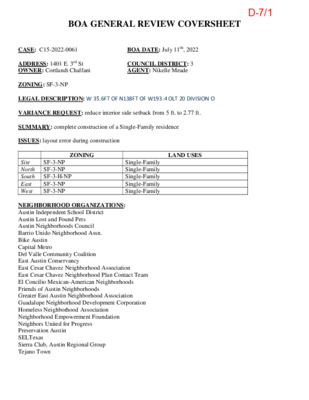
BOA GENERAL REVIEW COVERSHEET CASE: C15-2022-0061 BOA DATE: July 11th, 2022 ADDRESS: 1401 E. 3rd St OWNER: Cortlandt Chalfant COUNCIL DISTRICT: 3 AGENT: Nikelle Meade ZONING: SF-3-NP LEGAL DESCRIPTION: W 35.6FT OF N138FT OF W193.4 OLT 20 DIVISION O VARIANCE REQUEST: reduce interior side setback from 5 ft. to 2.77 ft. SUMMARY: complete construction of a Single-Family residence ISSUES: layout error during construction ZONING LAND USES Site North South East West SF-3-NP SF-3-NP SF-3-H-NP SF-3-NP SF-3-NP Single-Family Single-Family Single-Family Single-Family Single-Family NEIGHBORHOOD ORGANIZATIONS: Austin Independent School District Austin Lost and Found Pets Austin Neighborhoods Council Barrio Unido Neighborhood Assn. Bike Austin Capital Metro Del Valle Community Coalition East Austin Conservancy East Cesar Chavez Neighborhood Association East Cesar Chavez Neighborhood Plan Contact Team El Concilio Mexican-American Neighborhoods Friends of Austin Neighborhoods Greater East Austin Neighborhood Association Guadalupe Neighborhood Development Corporation Homeless Neighborhood Association Neighborhood Empowerment Foundation Neighbors United for Progress Preservation Austin SELTexas Sierra Club, Austin Regional Group Tejano Town D-7/1 C15-2022-0061 12953473 0204061201 Council District: 3 D-7/2 D-7/3 ____________________________________________________________________________ Allowing the existing structure to remain will not alter the character of the area, impair the use of ____________________________________________________________________________ the adjacent conforming property, or impair the purpose of the regulations because it is ___________________________________________ _____________________ common for structures to be placed in setbacks in this neighborhood because of discrepancies ____________________________________________________________________________ and errors in the original surveying and lot creation. ____________________________________________________________________________ ____________________________________________________________________________ - - 1. 2. 3. 4. ____________________________________________________________________________ ____________________________________________________________________________ ____________________________________________________________________________ ____________________________________________________________________________ ____________________________________________________________________________ ____________________________________________________________________________ ____________________________________________________________________________ ____________________________________________________________________________ ____________________________________________________________________________ ____________________________________________________________________________ ____________________________________________________________________________ ____________________________________________________________________________ ____________________________________________________________________________ ____________________________________________________________________________ ____________________________________________________________________________ ____________________________________________________________________________ | Board of Adjustment General/Parking Variance Application | Page 6 of 8 D-7/4 D-7/5 D-7/6 3 4 L14 T. S Outlot 19 3 1 1 L23 3 1 L 3 1 3 2 0 4 3 2 T. S 2 1 L 3 1 R E L L A W 1 1 L 0 3 3 1 0 L10 9 2 3 6 8 2 3 3 5 EAST T. N S NIO O 7 2 L T. S 4 1 Subject Tract L15 3RD ST. 8 1 L 3 3 0 L24 4 2 C A Y A T T A 2 2 L 3 3 7 A T O S A V A N 6 2 L 3 0 9 L9 L8 2 8 4 2 3 L28 L25 Outlot 20 EAST 2ND ST. Division "O" Formerly: EAST 1ST ST 7 L7 2 4 0 3 5 0 3 2 3 7 1 L T. S 4 2 5 4 0 1 3 0 8 3 9 2 T. A S T O S A V A N INSET MAP No Scale (28.03) 27.97 g k ric Bld B 0+79.94 E " 7 2'4 3 ° 0 2 N r r's e e fo e gin rlin r St. n City E nte alle e C W (28.04) 28.12 5) 9.9 4 9.9 (3 3 5) 9.9 6 9.9 (3 3 3 2.5 6 + 9 3 8 2.5 8 + 9 3 3 0 1 0+00 9 0.5 1 + 0 4 City Engineer's Monument Line N69°36'18"W Survey Completed 09/12/2021 Graphic Scale 0 100 200 400 F e e t Reconstruction of City Engineer's Monument Lines : Sheets 1 and 2 of this map show the reconstruction of the City Engineer's Monument lines in the vicinity of Outlot 20 from which old boundaries and evidence thereof perpetuated by surveys made by the City Engineer and his staff at early dates in the 20th century were also reconstructed as a part of the determination of the boundaries of the Subject Property. Boundary of Subject Property : Sheet 3 shows the boundary of the Subject Property as determined by my resurvey and improvements in place upon it. Legend City Engineer's Monument Line marking Baseline or Established Centerline as noted in KEY TO SURVEY MARKS on Sheet 2 (or common line of Outlots 19 and 20 where symbol appears in Navasota Street) LNo. Refer to LINE DATA TABLE on Sheet 2 (Data) Tie Data in Parentheses from Monument Lines to Building Corners is from City FB 1118 Pg 7 dated 10/30/1936 or City Engineer's District Map No.10 L19 Refer by Number to KEY TO SURVEY MARKS on Sheet 2 for marker descriptions 1 0 1 1 1 L 2 1 0 0 2 L A M O C 6 1 L 3 0 2 h t r o N d i r G Outlot 21 3 0 6 L20 L29 1 2 L Outlot 22 EAST CESAR CHAVEZ L6 2 L 7 0 3 3 3 L T. S 2 0 1 4 3 0 1 L5 N O HIC 4C L 5 0 0 2 1 0 2 MAP FOR SURVEYOR'S REPORT No. 21-1009 Upon the Lot known locally as 1401 East 3rd Street, in Outlot 20 of Division "O" of the City of Austin, Travis County, Texas Map No. 21-1009 Sheet 1 of 3 D-7/7 K E Y T O S U R V E Y M A R K S In the following list "Standard Spike and Washer" denotes a Punchmark on a 3/8 in. Spike with a 2 in. Aluminum Washer stamped "KENT MCMILLAN, SURVEYOR, RPLS 4341" and numbered as noted, set in a Hole Drilled in a Concrete Curb or Pavement No. Description 1-5 Set Standard Spike and Washer (in 2015) 23 Set Standard Spike and Washer SE Cor E 3rd & Comal 24 Set Standard Spike and Washer NE Cor E 2nd & Comal 25 Set Standard Spike and Washer SW Cor E 2nd & Comal 27 Set Standard Spike and Washer in Sidewalk at 1408 E 1st 28 Set Standard Spike and Washer in Curb Laydown NW Cor E 1st & Navasota 29 Set Standard Spike and Washer on E side Driveway at 1208 E 1st 30 Set Standard Spike and Washer NE Cor E 1st & Waller 31 Set Standard Spike and Washer NW Cor E 2nd & Waller (N side of Inlet on Waller) 32 Set Standard Spike and Washer SE Cor E 3rd & Waller 34 Set Standard Spike and Washer NW Cor E 3rd & Attayac 35 Set Standard Spike and Washer SE Cor E 3rd & Navasota 36 Set Standard Spike and Washer NW Cor E 3rd & Navasota 41 Set Standard Spike and Washer in Gutter E side of Navaosta at Alley 42 Set Standard Spike and Washer NW Cor E 2nd & Navasota 100 Found (in 2015) 1/4 in. Copper Pin in Concrete in Iron Casting on Established Centerline of Chicon St 101 Found (in 2015) 1/4 in. Copper Pin in Concrete in Iron Casting on Established Centerline of Chicon St from which Copper Pin: - Spike and Washer No. 1 bears S02-50-25E, 52.25 ft. 102 Found (in 2015) 1/4 in. Copper Pin in Concrete in Iron Casting on Established Centerline of Chicon St from which Copper Pin: - Spike and Washer No.4 bears S14-15-49E, 34.40 ft. 200 Reconstructed Position of Intersection of Established Centerlines of Chicon Street and East 1st St from which Point: - Spike and Washer No.5 bears N11-19-10W, 34.32 ft. 201 Reconstructed Position of Concrete Monument on Established Centerline of Chicon Street at Intersection of Monument Line Offset 10 ft. South of Established Centerline of East 1st Street from which Point: - Spike and Washer No.5 bears N04-18-04W, 43.14 ft. 301 Reconstructed Position of City Engineer's Monument on 10 ft. Offset Baseline in E 1st St 302 Reconstructed Position of City Engineer's Monument on 10 ft. Offset Baseline in E 1st St at Intersection of Established Centerline of Comal St 304 Reconstructed Position of City Engineer's Monument on Established Centerline of Comal St at Intersection of City Engineer's Baseline for E 3rd between Navasota and Comal from which Point: - Spike and Washer No.23 bears S35-17-33E, 26.07 ft. 305 Reconstructed Position of City Engineer's Monument on Established Centerline of Comal St at Intersection of City Engineer's Baseline for E 3rd running East from Comal 306 Reconstructed Position of City Engineer's Monument on City Engineer's baseline for E 3rd between Comal and Chicon 308 Reconstructed Position of City Engineer's Monument on 10 ft. Offset Baseline in E 1st St at intersection of Baseline for Navasota St. running South from which Point: - Spike and Washer No.28 bears N32-30-17W, 55.69 ft. 309 Reconstructed Position of City Engineer's Monument on 10 ft. Offset Baseline in E 1st St at intersection of Basline for Attayac St. from which Point - Spike and Washer No.29 bears N48-15-01W, 88.08 ft. 310 Reconstructed Position of City Engineer's Monument on 10 ft. Offset Baseline in E 1st St at intersection of Established Centerline of Waller St running North from which Point: - Spike and Washer No.30 bears N56-09-06E, 41.78 ft. 311 Reconstructed Position of City Engineer's Monument at Intersection of Established Centerlines of Waller St and E 2nd St running East from which Point: - Spike and Washer No.31 bears N06-05-30W, 45.27 ft. 313 Reconstructed Position of City Engineer's Monument at Intersection of Established Centerlines of Waller St and E 3rd St running East to Navasota 324 Reconstructed Position of Stone Monument set by R.W. Ford in 1870 to mark the South common corner of Outlots 19 and 20, Div "O" from which Point: - Spike and Washer No.28 bears S89-14-26W, 13.61 ft. and - Spike and Washer No.27 bears S68-22-34E, 251.43 ft. 328 Reconstructed Position of Stone Monument set by R.W. Ford in 1870 to mark the North common corner of Outlots 19 and 20, Div "O" from which Point: - Spike and Washer No.35 bears S11-03-23E, 25.60 ft. - Spike and Washer No.36 bears N12-19-44w, 27.53 ft. 329 Point on City Engineer's 10 ft. Offset Baseline in E 1st St at intersection of S'ly prolongation of common line of Outlots 19 and 20 330 Reconstructed Position of intersection of Baseline in Attayac St and Established Centerline of E 2nd St as shown in City FB 2521 Pg 48-49 337 Intersection of Established Centerline of E 2nd St and common line of Outlots 19 and 20, Div "O" from which Point: - Spike and Washer No.42 bears N00-35-31W, 30.31 ft. 401 Found 1/4 in. Copper Pin in Concrete in Iron Casting at intersection of Established Centerlines of Comal St and E 2nd St and from which Copper Pin: - Spike and Washer No.24 bears N60-56-43E, 35.49 ft. - Spike and Washer No.25 bears S59-25-57W, 36.20 ft. 402 Found 1/4 in. Copper Pin in Concrete without Iron Casting (under Street Pavement, 0.55 ft. Down) from which Pin: - Spike and Washer No.32 bears S71-15-13E, 20.45 ft. - Spike and Washer No.34 bears S78-37-53E, 326.83 ft. - Spike and Washer No.31 bears S24-38-42W, 284.21 ft. COORDINATE LIST Coordinates in the following list are in units of US Survey Feet and refer to the Texas Coordinate System of 1983 (Central Zone); NAD83 (2011 Epoch 2010.0 as derived by connection to the local segment of the National CORS network and estimated from analysis of variance to have uncertainies (standard errors) less than +/-0.02 ft.in N and E components. No. N (ft.) E (ft.) 1 10068171.144 3120635.097 2 10067920.384 3120491.174 3 10067569.023 3120362.525 4 10067203.782 3120272.452 5 10066940.541 3120133.846 23 10068028.847 3119123.573 24 10067731.120 3119012.308 25 10067695.477 3118950.118 27 10067557.810 3118471.095 28 10067650.281 3118223.767 29 10067786.835 3117852.139 30 10067871.449 3117629.804 31 10068234.032 3117718.055 32 10068485.770 3117855.934 34 10068427.923 3118156.965 35 10068258.126 3118483.871 36 10068310.147 3118473.083 41 10068107.415 3118426.192 42 10067981.695 3118351.945 46 10068179.684 3118454.243 100 10067897.260 3120510.679 101 10068223.327 3120632.508 102 10067237.115 3120263.978 200 10066906.895 3120140.581 201 10066897.528 3120137.081 301 10067138.702 3119496.046 302 10067379.826 3118854.889 304 10068050.127 3119108.510 305 10068052.920 3119109.564 306 10067815.509 3119750.552 308 10067603.321 3118253.689 309 10067728.189 3117917.847 310 10067848.181 3117595.110 311 10068189.020 3117722.859 313 10068517.589 3117846.136 324 10067650.461 3118237.370 328 10068283.251 3118478.961 329 10067614.494 3118223.638 330 10068066.930 3118046.224 333 10068240.080 3118516.934 334 10068252.538 3118483.291 335 10068122.663 3118433.706 336 10068110.215 3118467.006 337 10067951.384 3118352.258 401 10067713.887 3118981.288 402 10068492.344 3117836.565 423 10068108.686 3118466.418 432 10068239.666 3118516.775 441 10068263.091 3118452.544 455 10068065.951 3118523.717 456 10068101.572 3118429.842 471 10068110.907 3118467.255 LINE DATA TABLE Bearings refer to Grid North of the Texas Coordinate System of 1983 (Central Zone). Distances are Horizontal Surface Distances in units of US Survey Feet, computed using an Average Combined Scale Factor of 0.999947 Surface Dist = Grid Dist/0.999947 No. From-To Bearing Distance dd-mm-ss L1 101-100 S20-29-14W 348.10 L2 100-307 S20-29-29W 340.69 L3 307-102 S20-29-27W 364.09 L4 102-201 S20-29-23W 362.54 L4 102-200 S20-29-23W 352.54 L5 201-301 N69-22-57W 684.94 L6 301-302 N69-23-24W 685.03 L7 302-308 N69-36-27W 641.43 L8 308-309 N69-36-16W 358.32 L9 329-309 N69-36-16W 326.26 L10 309-310 N69-36-18W 344.34 L11 310-311 N20-32-47E 364.01 L12 311-402 N20-32-58E 323.95 L13 402-313 N20-45-41E 27.00 L14 313-328 S69-40-49E 674.86 L15 328-304 S69-40-49E 671.36 L16 302-401 N20-43-31E 357.19 L17 401-304 N20-43-30E 359.52 L18 304-305 N20-40-30E 2.99 L19 305-306 S69-40-34E 683.58 L20 306-307 S69-40-36E 683.45 L21 301-306 N20-36-30E 723.12 L22 309-330 N20-45-21E 362.27 L23 311-330 S69-18-56E 345.66 L24 330-337 S69-18-56E 327.14 L25 337-401 S69-18-56E 672.41 L26 329-337 N20-53-47E 360.63 L27 337-328 N20-53-47E 355.25 L28 308-329 N69-36-16W 32.06 L29 401-102 S69-36-36E 1368.50 The above represents the results of a comprehensive readjustment of data from surveys performed by the City Engineer and his staff from 1931 through 1962, including the data from following City records: City FB 743 Pg 28 __/__/1932 City FB 973 Pg 49-50 02/06/1934 City FB 953 Pg 36 05/22/1931 City FB 984 Pg 18 03/18/1935 City FB 1118 Pg 7&8 10/30/1936 City FB 2521 Pg 48 05/23/1961 City Engineer's Map of District 15 dated 08/20/1940 I, Kent Neal McMillan, a Registered Professional Land Surveyor, hereby certify that this Map No. 21-1009, consisting of Sheets 1, 2, and 3, taken together with my Surveyor's Report No. 21-1009 prepared to accompany them, is a true and correct representation of the results of an actual resurvey performed upon the ground under my direction for the purpose of determining the boundaries of the property known as 1401 East 3rd St. in Outlot 20, Division "O" of the City of Austin, Travis County, Texas. Sheets 1 and 2 of this map show the reconstruction of the City Engineer's Monument lines in the vicinity of said Outlot 20 from which old boundaries and evidence thereof perpetuated by surveys made by the City Engineer and his staff at early dates in the 20th century were also reconstructed as a part of the determination of the boundaries of the Subject Property. Sheet 3 shows the boundary of the Subject Property as determined by my resurvey and improvements in place upon it. Witness my hand and seal of registration, September 22, 2021. Kent Neal McMillan Registered Professional Land Surveyor No. 4341 1200 Cascade Trail, San Marcos TX 78666 Telephone (512) 667-7455 MAP FOR SURVEYOR'S REPORT No. 21-1009 Upon the Lot known locally as 1401 East 3rd Street, in Outlot 20 of Division "O" of the City of Austin, Travis County, Texas Map No. 21-1009 Sheet 2 of 3 D-7/8 D-7/9 D-7/10 D-7/11 D-7/12 D-7/13 D-7/14 D-7/15 D-7/16 D-7/17 D-7/18 111 Congress Avenue, Suite 1400 Austin, Texas 78701 Direct/Mobile: 512.992.6001 Nikelle Meade Partner June 24, 2022 The Board of Adjustment c/o Elaine Ramirez Planner Senior and Board of Adjustment Liaison City of Austin Development Services Department 6310 Wilhelmina Delco Dr Austin, Texas 78752 Re. Request for Sideyard Setback Variance to Preserve Existing Single-Family Home with Accessory Apartment at 1401 E. 3rd Street, Austin, 78702, District 2 On behalf of the owner of the above referenced Property, please accept the enclosed request for a variance to reduce a side-yard setback from 5 feet to 2.77 feet to preserve the existing single family home and accessory apartment. This site was reviewed by the Board in 2020, but although the existing hardship existed at the time the case was considered, the applicant failed to present proper evidence to explain what the hardship was and the reasons it was not in any way caused by the property owner. The property now has a new owner, and we, on behalf of that new owner, wish to ask for the Board’s review. Sincerely, Nikelle S. Meade NSM/sm Enclosure HB: 4863-8153-8566.1 D-7/19 Location Map D-7/20 D-7/21 D-7/22 D-7/23