D-1 C15-2022-0025 ADV PACKET — original pdf
Backup
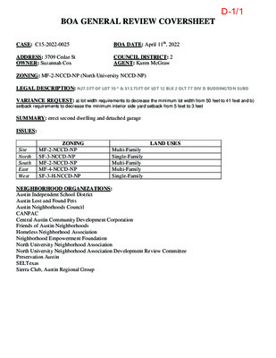
BOA GENERAL REVIEW COVERSHEET CASE: C15-2022-0025 BOA DATE: April 11th, 2022 ADDRESS: 3709 Cedar St OWNER: Suzannah Cox COUNCIL DISTRICT: 2 AGENT: Karen McGraw ZONING: MF-2-NCCD-NP (North University NCCD-NP) LEGAL DESCRIPTION: N27.5FT OF LOT 10 * & S13.75FT OF LOT 12 BLK 2 OLT 77 DIV D BUDDINGTON SUBD VARIANCE REQUEST: a) lot width requirements to decrease the minimum lot width from 50 feet to 41 feet and b) setback requirements to decrease the minimum interior side yard setback from 5 feet to 3 feet SUMMARY: erect second dwelling and detached garage ISSUES: ZONING LAND USES MF-2-NCCD-NP Site North SF-3-NCCD-NP South MF-2-NCCD-NP East MF-4-NCCD-NP West SF-3-H-NCCD-NP Multi-Family Single-Family Multi-Family Multi-Family Single-Family NEIGHBORHOOD ORGANIZATIONS: Austin Independent School District Austin Lost and Found Pets Austin Neighborhoods Council CANPAC Central Austin Community Development Corporation Friends of Austin Neighborhoods Homeless Neighborhood Association Neighborhood Empowerment Foundation North University Neighborhood Association North University Neighborhood Association Development Review Committee Preservation Austin SELTexas Sierra Club, Austin Regional Group D-1/1 3709 Cedar Street A portion of Lot 10 and Lot 12 of Buddington's Subdivision, N. 27.5FT of lot 10 and A13.75FT of Lot 12 77 MF2-NCCD-NP 2 D Karen McGraw Suzannah Cox Select Select Select Second Dwelling and separate Garage D-1/2 (see full text on P. 8) This site has a 41' front width which is the narrowest on the block except for 3711 which has the same and a new home is being constructed there now. The Owner wishes to maintain the existing 854 SF home and add a second dwelling of 850 SF limit per code. All other lots are either developed as multi-family or have the lot size and width to create a second dwelling. except for 3711 which is underconstruction. The garage needs to be relocated to allow alley access but due to tree protection it needs to use the 3' side setback. Only two lots on this block have this 41' lot width. All others are wider except next door at 3711 Cedar has a new house being constructed that will utilize it's entire .4 FAR (.39) D-1/3 This development will be far less dense than the apartments to the north, south and east and will be one story with loft and neighboring buildings are all two stories or greater. These two units will require less parking and produce less traffic than the multi-family uses surroudning it and the Austin Groups for the Elderly (AGE) that lies to the west. D-1/4 Austin TX 78751 03/10/2022 Karen McGraw 4315 Avenue C 512-459-2261 Suzannah Cox 3709 Cedar Street (361) 557-1960 Austin TX 78705 Karen McGRaw 4315 Avenue C 512-459-2261 Austin TX 78751 D-1/5 First variance: North University NCCD No. 040826-058 Part 7 (1) requires a lot minimum width of 50'. and Owner requests a variance to allow two-family use on this lot with a 41' lot width. Note that the Ordinance 20110804-040 Part 3 (5) (b) Allows 2-family use on a lot at least 5,750 SF. The existing lot is 41' wide and contains 6,636 SF. Second variance: North University NCCD No. 040826-058 Part 7 (1) requires a 5' side setback and the Owner requests a variance to place a new accessory buidling (garage) with a 3' setback from the south side property line. Note - North University NCCD No. 040826-058 Part 7 (3) (d) " a non-complying accessory buidling may be reconstructed at its existing location, but may not be less than 3' from the rear and interior side property lines". The owner requests to remove the existing garage and replace it with a new garage 3' from the south property line - not on its existing location. D-1/6 PROPERTY ADDRESS:POINTS OF INTEREST:BUYER:SELLER:CERTIFIED TO:CLIENT NUMBER:DATE:SURVEY NUMBER:FIELD WORK DATE:REVISION DATE(S):This is page 1 of 2 and is not valid without all pages.FLOOD INFORMATION:1802.26303709 CEDAR STREET, AUSTIN, TEXAS 78705Suzannah C BarnebeyMICHAEL CADENA3/6/20183/1/2018SUZANNAH C BARNEBEYBY PERFORMING A SEARCH WITH THE LOCAL GOVERNINGMUNICIPALITY OR WWW.FEMA.GOV, THE PROPERTY APPEARS TO BELOCATED IN ZONE X. THIS PROPERTY WAS FOUND IN THE CITY OFAUSTIN, COMMUNITY NUMBER 480624, DATED 10/06/16.NONE VISIBLEPREPARED BY:(REV.0 3/6/2018) D-1/7 REPORT OF SURVEYGENERAL SURVEYOR NOTES:LEGEND:JOB SPECIFIC SURVEYOR NOTES:ELECTRONIC SIGNATURE:PRINTING INSTRUCTIONS:LEGAL DESCRIPTION:This is page 2 of 2 and is not valid without all pages. OFFER VALID ONLY FOR:1802.2630Suzannah C BarnebeyTHE BEARING REFERENCE OF SOUTH 60 DEGREES 34 MINUTES 23 SECONDS EAST IS BASED ON THE PROPERTY LINE OF , LOCATED WITHINACCORDING TO THE PLAT THEREOF, AS RECORDED IN FILM CODE NO. OF THE MAP RECORDS OF TRAVIS COUNTY, TEXAS.FIELD NOTE DESCRIPTION OF A 0.152 ACRE TRACT OF LAND, BEING A PORTION OF LOT 10 AND LOT 12 OF BUDINGTON'S SUBDIVISION, A SUBDIVISION OUT OF OUTLOT 71, DIVISION AND RECORDED IN VOLUME 1, PAGE 54 OF THE PLAT RECORDS OF TRAVIS COUNTY,TEXAS SAID 0.152 ACRE TRACT BEING THE SAME AS CONVEYED IN A GENERAL WARRANTY DEED WITHVENDOR'S LIEN FROM JANET RAGSDALE TO RAYMUNDO LOPEZ, JR. AND MARGARET E. LOPEZ AND RECORDED IN VOLUME 12378, PAGE 556, OF THE REAL PROPERTYRECORDS OF TRAVIS COUNTY, TEXAS, SAID 0.152 TRACT BEING MORE PARTICULARLY DESCRIBED BY METES AND BOUNDS AS FOLLOWS:BEGINNING AT A 1" PIPE FOUND ON THE SOUTHEAST LINE OF CEDAR STREET AND THE NORTHWEST LINE OF LOT 10, AT THE NORTH CORNER OF THE BYLER, INC. TRACT OF LAND RECORDED IN VOLUME 8815, PAGE 1082, AND THE WEST CORNER OF THIS TRACT HEREINDESCRIBED;THENCE, ALONG THE COMMON LINE OF THIS TRACT AND CEDAR STREET, NORTH 27° 11' 48" EAST (RECORD = NORTH 27° 17' 39° EAST), A DISTANCE OF 41.19 FEET (RECORD = 41.13 FEET) TO A 1-1/4" PIPE FOUND AT THE WEST CORNER OF THE WILLIAM CHRISTENSENTRACT OF LAND RECORDED IN VOLUME 11852, PAGE 511, AND THE NORTH CORNER OF THIS TRACT HEREIN DESCRIBED;THENCE, DEPARTING THE SOUTHEAST LINE OF CEDAR STREET AND ALONG THE COMMON LINE OF THIS TRACT AND SAID CHRISTENSEN TRACT,SOUTH 60° 34' 23" EAST (RECORD †"BASIS OF BEARING"), A DISTANCE OF 161.30 FEET (RECORD = 161.80 FEET) TO A 1/2" IRON PIPE FOUND ON THE NORTHWEST LINE OF AN ALLEYWAY, AT THE SOUTH CORNER OF THE CHRISTENSEN TRACT AND THE EAST CORNER OFTHIS TRACT HEREIN DESCRIBED;THENCE, ALONG THE COMMON LINE OF THIS TRACT AND SAID ALLEYWAY, SOUTH 29° 09' 52" WEST (RECORD SOUTH 29° 22' 38" WEST), A DISTANCE OF 41.36 FEET (RECORD = 41.31 FEET) TO A 1/2" REBAR SET FOR THE SOUTH CORNER OFTHIS TRACT HEREIN DESCRIBED AT THE EAST CORNER OF THE AFOREMENTIONED BYLER, INC. TRACT, FROM WHICH A 1/2" IRON PIPE FOUND AT THE SOUTH CORNER OF LOT 8 BEARS SOUTH 29° 09' 62" WEST, A DISTANCE OF 79.52 FEET;THENCE, DEPARTING THENORTHWEST LINE OF SAID ALLEYWAY AND ALONG THE COMMON LINE OF THIS TRACT AND SAID BYLER, INC. TRACT, NORTH 60° 30' 00" WEST (RECORD = NORTH 60° 30' 00" WEST), A DISTANCE OF 150 FEET (RECORD = 160.31 FEET) TO THE POINT OF BEGINNING.*Offer valid for fence stakeouts and additions to the existing structures only. Valid only for the buyer as listed on the first page of this survey for up to one year after survey issuance date. Total discount not to exceed $500. 10% off1. While viewing the survey in Adobe Reader, select the “Print” button under the “File” tab.2. Select a printer with legal sized paper. 3. Under “Print Range”, click select the “All” toggle.4. Under the “Page Handling” section, select the number of copies that you would like to print.5. Under the “Page Scaling” selection drop down menu, select “None.”6. Uncheck the “Auto Rotate and Center” checkbox.7. Check the “Choose Paper size by PDF” checkbox.8. Click OK to print.TO PRINT IN BLACK + WHITE:1. In the main print screen, choose “Properties”.2. Choose “Quality” from the options.3. Change from “Auto Color” or “Full Color” to “Gray Scale”. In order to “Electronically Sign” all of the PDFs sent by STARS, you must use a hash calculator. A free online hash calculator is available at http://www.fileformat.info/tool/md5sum.htm. To Electronically Sign any survey PDF: 1. Save the PDF onto your computer. 2. Use the online tool at http://www.fileformat.info/tool/md5sum.htm to browse for the saved PDF on your computer. 3. Select the Hash Method as SHA. 4. Click Submit. Your PDF is electronically signed if all of the characters in the SHA-1 code submitted by STARS matches the code which is produced by the hash calculator. If they match exactly, your PDF is electronically signed. If the codes do not match exactly, your PDF is not authentic. D-1/8 EXHIBIT AJOB NUMBER: DATE:REVISION DATE(S):1802.26303/6/2018(REV.0 3/6/2018) Description of a 0.152 acre tract of land, being a portion of Lot 10 and Lot 12 of Budington's Subdivision of part of Out Lot 77 in Division D of the Austin City Out Lots, a subdivision recorded in Volume 1, Page 54 of the Plat Records of Travis County, Texas (P.R.T.C.Tx.), being all of that called 0.152 acre tract of land conveyed to Michael Cadena, A single man, by Warranty Deed With Vendor’s Lien, as recorded in Document No. 2000149494 of the Official Public Records of Travis County, Texas (O.P.R.T.C.Tx.), said 0.152 acre tract of land being more particularly described by metes and bounds as follows: BEGINNING at a ½” iron pipe found for the Southwest corner of that tract called “Lot 12, Block 2 of said Buddington Subdivision, less the South 13.75 feet”, as conveyed to Amy S. Bannerman by General Warranty Deed recorded in Document No. 2013183721 O.P.R.T.C.Tx., and the Northeast corner and POINT OF BEGINNING hereof; THENCE , over and across said Lot 12, with the South line of said Bannerman tract and the North line hereof, South 60° 34' 23" East (Record South 60° 34' 23" East ), a distance of 161.83 feet (Record 161.80 feet) to a 1/2" iron pipe found on the Northwest line of an alley, for the Southeast corner of said Bannerman tract and the Northeast corner hereof; THENCE , with said Northwest line of an alley, the East line of said Lot 12, the East line of said Lot 10, and the East line hereof, South 30°08’54” West (Record South 29° 09' 52" west), a distance of 41.06 feet (Record 41.36 feet) to a ½” iron rod found for the Southeast corner hereof and the Northeast corner of that called 0.30 acre tract of land conveyed to Cedar Street, LLC by Special Warranty Deed, as recorded in Document No. 2014140937 O.P.R.T.C.Tx., as established by that Final Judgement recorded in Document No. 2008172202 O.P.R.T.C.Tx., from which a 1/2" iron rod found at the Southeast corner of said 0.30 acre tract of land bears South 29° 59' 23" West (Record South 29°58’42 West), a distance of 82.24 feet (Record 82.20 feet); THENCE , departing the Northwest line of said alleyway, over and across said Lot 10, with the North line of said 0.30 acre tract of land and the South line hereof, as established by said Final Judgement, North 60°34’11” West (Record North 60°36’04” West), a distance of 160.40 feet (Record 160.28 feet) to a ½” iron rod found on the Southeast right-of-way line of Cedar Street and the Northwest line of said Lot 10, at the Northwest corner of said 0.30 acre tract and the Southwest corner hereof; THENCE with said Southeast right-of-way line of Cedar Street, said Northwest line of Lot 10, said Northwest line of Lot 12, and and the Northwest line hereof, North 28°09’14” East (Record North 27° 11' 48" East), a distance of 41.05 feet (Record 41.19 feet) to the POINT OF BEGINNING , and containing 0.152 acres (6,613 sq. ft.) of land, more or less. D-1/9 CEDAR STREET (55' R/W) W M LINE OF CURB 41.25' (D) N 29°45'34" E 41.36' (M) 1/2" FIP 1/2" FIP P . O . B 5.3' D O C . N O . 2 0 1 3 1 8 3 7 2 1 L E S S S O U T H 1 3 . 7 5 ' L O T 1 2 B L K 2 A M Y S . B A N N E R M A N N 28°09'14" E 41.05' (M) // 1/2" FIR 1 7 . 5 ' 2 4 . 0 ' D O C . N O . 2 0 1 4 1 4 0 9 3 7 0 . 3 0 A C R E S C E D A R S T R E E T , L L C 10.9' / / / / / / / / / / / / / / / / N ° 6 0 3 4 1 1 ' " W 1 6 0 4 0 . ' ( M ) / / / / / / / / / / / / / / 10.4' 2.3' D O C . N O . 2 0 0 0 1 4 9 4 9 4 . 0 1 5 2 A C R E S 3 2 . 2 ' W O O D S H E D R E M O V E D 2 7 . 4 ' ° S 6 0 3 4 2 3 ' " E 1 6 1 . 8 3 ' ( M ) O H L O H L SITE PLAN PROPOSED 0 10' 20' 40' 1" = 20'-0" 1/2" FIR S 30°08'54" W 41.06' (M) 3/8" FIR PAVED ALLEY - 16' R.O.W. 1 O F 1 P L A N I S T E . . . 0 3 0 7 . 2 0 2 2 3709 CEDAR STREET . c K are n M Gra w, Arc hite ct C o n stru ctio n n d e N ot inte d for R ulatory e g A p pro v al, P ermittin g, or F or interim re vie w o nly # 6 4 9 5 Karen McGraw Architect PLLC 4315 Avenue C Austin, Texas 78751 512-917-1761 mcgrawka@earthlink.net D-1/10 2/24/2022 Property Profile Map Changed. Center latitude: 30.3001 degrees North. Center longitude: 97.7341 degrees West. Visible Features: 69 features visible on Addresses. 14 features visible on Zoning Ordinance. 38 features visible on Zoning Text. 38 features visible on Zoning. Tools GreySca… 0 50 100ft https://www.austintexas.gov/GIS/PropertyProfile/ 1/1 D-1/11 D-1/12 ORDINANCE NO. 040826-58 AN ORDINANCE REZONING AND CHANGING THE ZONING MAP ACCOMPANYING CHAPTER 25-2 OF THE CITY CODE TO ESTABLISH THE NORTH UNIVERSITY NEIGHBORHOOD CONSERVATION-NEIGHBORHOOD PLAN (NCCD-NP) COMBINING DISTRICT FOR THE PROPERTY WHOSE BOUNDARIES ARE 38™ STREET TO THE NORTH, SAN JACINTO BOULEVARD AND 27™ STREET TO THE SOUTH, GUADALUPE STREET TO THE WEST AND DUVAL STREET TO THE EAST, IN THE CITY OF AUSTIN, TRAVIS COUNTY, TEXAS; AND TO MODIFY CERTAIN BASE DISTRICTS IN THE NCCD-NP. BE IT ORDAINED BY THE CITY COUNCIL OF THE CITY OF AUSTIN: PART 1. The zoning map established by Section 25-2-191 of the City Code is amended to establish the North University neighborhood conservation-neighborhood plan (NCCD-NP) combining district and to add a NCCD-NP to each base zoning district within the property and to change the base zoning districts on 74 tracts of land on the property described in Zoning Case No.C14-04-0022, on file at the Neighborhood Planning and Zoning Department, as follows: Approximately 234.87 acres of land in the City of Austin, Travis County, Texas, more particularly described and identified in the attached Exhibit "A" incorporated into this ordinance, (the "Property"), generally known as the North University conservation-neighborhood plan combining district, locally known as the area bounded by 38th Street to the north, San Jacinto Boulevard and 27th Street to the south, Guadalupe Street to the west, and Duval Street to the east, in the City of Austin, Travis County, Texas, and generally identified in the map attached as Exhibit "B". PART 2. The base zoning of the 74 tracts shown in the chart below are changed from family residence (SF-3) district, multifamily residence low density (MF-2) district, multifamily residence medium density (MF-3) district, multifamily residence moderate- high density (MF-4) district, multifamily residence high density (MF-5) district, multifamily residence medium density-historic (MF-3-H) combining district, limited office (LO) district, general office (GO) district, general office-mixed use (GO-MU) combining district, neighborhood commercial (LR) district, general commercial services (CS) district, commercial-liquor sales (CS-1) district, and unzoned (UNZ) district to family residence Page 1 of 46 D-1/13 neighborhood conservation-neighborhood plan (SF-3-NCCD-NP) combining district, multifamily residence limited density-neighborhood conservation-neighborhood plan (MF- 1-NCCD-NP) combining district, multifamily residence low density-neighborhood combining district, multifamily conservation-neighborhood plan (MF-2-NCCD-NP) residence medium density-neighborhood conservation-neighborhood plan (MF-3-NCCD- NP) combining district, multifamily residence moderate high density-neighborhood conservation-neighborhood plan (MF-4-NCCD-NP) combining district, multifamily residence high density-neighborhood conservation-neighborhood plan (MF-5-NCCD-NP) combining district, multifamily limited density-historic-neighborhood conservation-neighborhood plan (MF-1-H-NCCD-NP) combining district, multifamily residence low density-historic-neighborhood conservation-neighborhood plan (MF-2-H- NCCD-NP) residence medium density-historic- neighborhood conservation-neighborhood plan (MF-3-H-NCCD-NP) combining district, (NO-NCCD-NP) neighborhood office-neighborhood conservation-neighborhood plan combining district, limited office-neighborhood conservation-neighborhood plan (LO- NCCD-NP) combining district, community commercial-neighborhood conservation- neighborhood plan (GR-NCCD-NP) combining district, neighborhood commercial- neighborhood conservation-neighborhood plan (LR-NCCD-NP) combining district, general commercial services-neighborhood conservation-neighborhood plan (CS-NCCD- NP) combining district, and public-neighborhood conservation-neighborhood plan (P- NCCD-NP) combining district. combining district, multifamily residence TRACT APD-843 APD-846 APD-848 APD-850 APD-851 APD-852 APD-853 APD-855 APD-856 . . ADDRESS 3004-A FRUTH ST; 502 W 30TH ST 501, 503 W 30TH ST; 2910 FRUTH ST 500. 510W29THST 0 FRUTH ST (W PT OF LOT 4-7 BLK 2 OLT 73 DIV D FRUTH ADDN) 0 W 30TH ST (W TRI OF LOT 1 0-1 1 BLK 2 OLT 73 DIV D FRUTH ADDN) 0 WEST DR (PART OF LOT 2-7&10-14 * & ALLEY BLK 2 OLT 73 DIV D FRUTH ADDN) 0 W 29TH ST (E PT OF LOT 1-4,14-15 BLK 2 OLT 74 DIV D FRUTH ADDN) 0 HEMPHILL PARK (W PART OF LOT 7-9 BLK 3 OLT 73 DIV D FRUTH ADDN) 0 (LOT 5,10-14 & E PT OF LOT 6-8 & ALLEY BLK 3 OLT 73 DIV D FRUTH ADDN), 201 W 30TH ST (THE PORTION OF BLK 4, ALLEY, & ADJ W25FT OF STREET OLT 73 DIV D FRUTH ADDN THAT EXTENDS FROM THE NORTH RIGHT-OF-WAY LINE OF W 29TH ST TO THE CENTERLINE OF WALLER CREEK) FROM CS LO LO, CS UNZ UN2 UNZ MF-3, UNZ UNZ TO GR-NCCD-NP GR-NCCD-NP GR-NCCD-NP P-NCCD-NP P-NCCD-NP P-NCCD-NP P-NCCD-NP P-NCCD-NP UNZ P-NCCD-NP APD-861 3001 CEDAR ST (N 156 FT OF S 176 FT OF BENCHMARK CONDOMINIUMS AMENDED) APD-861A APD-865 3001 CEDAR ST (S 20 FT OF BENCHMARK CONDOMINIUMS AMENDED} 2807, 2809, 281 1 HEMPHILL PARK; 305 W 29TH ST; GO GO MF-4-NCCD-NP MF-4-NCCD-NP MF-5 NO-NCCD-NP Page 2 of 46 D-1/14 TRACT GDC- 71 4A GDN- 701 A GDN- 704A GDS- 71 5A ADDRESS 2819 (E 37.79 FT LOT 2 BLK 2 OLT 14 DIV D FRUTH ADDN) GUADALUPE ST . .. . 505 W 38TH ST (E 16 FT LOT 3 BLK 2 OLT 77 DIV D LAKEVIEW ADDN) 510 W 35TH ST (E 16 FT LOT 3 BLK 1 OLT 77 DIV B STEINLE ADDN} 281 9 (E 37.79 FT AV & 1/2 ADJ 16 FT VAC ALLEY LOT 1 BLK 2 OLT 14 DIV D FRUTH ADDN FROM CS-1 TO CS-NCCD-NP LO GO CS-NCCD-NP CS-NCCD-NP CS-1 CS-NCCD-NP RDE-783A RDE-784 RDE-794 RDE-805A 3710 TOM GREEN ST 300 E 35TH ST; 3503 GROOMS ST 3405 HELMS ST 407 E 35TH ST; 3408 (S 5 FT LOT 6 BLK 9 RESUB OF BLK 9 GROOMS ADDN), 3410, 3412 DUVAL ST RDE-807A 3305 HELMS ST; 200, 202, 204 E 33RD ST RDE-809 305 E 34TH ST 31 1 E 34TH ST 3305 TOM GREEN ST 202 E 32ND ST 400, 402 E 32ND ST; 3203 TOM GREEN ST 301 E 32ND ST 300, 302, 304, 308 MOORE BLVD; 303. 305, 309 E 32ND ST; 3110, 3112 WALLING DR; 3111 GROOMS ST 308 MOORE BLVD; 3108 WALLING DR 301 , 303, 305, 309 MOORE BLVD; 3105 GROOMS ST 311 MOORE BLVD 200, 202, 206 E 31 ST ST; 31 03 GROOMS ST 208E31STST 3100, 3102, 3104 TOM GREEN ST; 3101, 3103, 3105, 3109 WALLING DR 403, 405, 407 E 32ND ST 3116BENELVADR 403 W 38TH ST 404 W 35TH ST 405 W 35TH ST 303, 305 W 35TH ST 408, 410 W 34TH ST; 3405 FRUTH ST 400W34THST 306, 308, 310, 312 W 34TH ST 3707, 3709 CEDAR ST 3703, 3705 CEDAR ST 3405 CEDAR ST 3201 HEMPHILL PARK 31 12 WHEELER ST (S 34 FT LOT 2 MARKOVITS & DILLER ADDN) 3006, 3008 HEMPHILL PARK Page 3 of 46 RDE-810A RDE-813 RDE-818A RDE-821 RDE-825 RDE-826 RDE-827 RDE-828 RDE-829 RDE-830 RDE-831 RDE-832 RDE-833 RDE-834 RDW- 729A RDW- 737A RDW- 739A RDW-740 RDW-742 RDW- 742B RDW- 742D RDW-745 RDW-746 RDW- 748A RDW-755 RDW- 763B RDW-766 MF-3 MF-3 MF-4 MF-3 MF-3, MF-2 MF-4 MF-4 MF-3 MF-4 MF-3 MF-4 MF-4 MF-4 MF-4 MF-4 MF-4 MF-4 MF-4 MF-4 MF-4 MF-4 MF-4 MF-4 MF-4 MF-3 MF-4 MF-3 MF-4 MF-4 MF-3 SF-3 MF-3 MF-3 SF-3-NCCD-NP MF-1-NCCD-NP MF-3-NCCD-NP SF-3-NCCD-NP SF-3-NCCD-NP MF-3-H-NCCD- NP MF-3-NCCD-NP MF-2-NCCD-NP MF-3-NCCD-NP SF-3-NCCD-NP MF-2-NCCD-NP SF-3-NCCD-NP MF-2-NCCD-NP SF-3-NCCD-NP MF-1-NCCD-NP MF-1-NCCD-NP MF-3-NCCD-NP SF-3-NCCD-NP SF-3-NCCD-NP MF-1-NCCD-NP MF-3-NCCD-NP MF-3-NCCD-NP SF-3-NCCD-NP MF-3-NCCD-NP SF-3-NCCD-NP SF-3-NCCD-NP MF-1-NCCD-NP MF-2-NCCD-NP SF-3-NCCD-NP SF-3-NCCD-NP P-NCCD-NP SF-3-NCCD-NP SF-3-NCCD-NP D-1/15 ADDRESS 0 HEMPHIILL PARK (1.05ACR APPROX LOT 1 BLK 2 OLT 74 DIV D ALDRIDGE PLACE) . . FROM SF-3 TO P-NCCD-NP 3105, 31 07 CEDAR ST 3013 HEMPHILL PARK 300 W 30TH ST 3706 SPEEDWAY 3704 (LOT 9 BLK 2 OLT 77 DIV D SIMMS RESUB OF BUDDINGTON SUBD) 102 W 35TH ST; 3502, 3504 SPEEDWAY 3500 SPEEDWAY 104 E 37TH, 3701, 3703 SPEEDWAY 3410, 3412, 3414 SPEEDWAY 3121 SPEEDWAY 3105 (W1/2 OF LOT 3 BLK 15 DIV D GROOMS ADDN), 3107. 3109, 3111 SPEEDWAY; 3104 (E1/2 OF LOT 3 BLK 15 DIV D GROOMS ADDN) HELMS ST GO, MF-4 , MF-4 CS cs SD-880A 31 08 (S45FT OF E69FT OF LOT 5 BLK 15 DIV D GROOMS ADDN) HELMS ST CS NO-NCCD-NP SJD-886 300, 302, 304, 306 E 30TH ST; 3001 SPEEDWAY 400, 402, 404, 406 E 30TH ST 303 E 30TH ST 2911 SAN JACINTO BLVD 309, 405, 407, 409 E 30TH ST; 2827 SAN JACINTO BLVD 41 1 E 30TH ST 506 W 37TH ST 502W35THST 3401 (E 1 17.39 FT OF S CEN 65.8 FT OF BLK 6 OLT 77 DIV D BUDDINGTON SUB) GUADALUPE ST 506 (S 94.35 FT OF THE E 202.93 FT BLK 6 OLT 77 BUDDINGTON SUB LESS THE PORTION DESCRIBED IN TRACT TD-728) W 34TH ST 506 (62%, MORE OR LESS, OF S 94.35 FT OF E 202.93 FT BLK 6 OLT 77 BUDDINGTON SUB) W 34TH ST MF-3-H 2803 HEMPHILL PARK (N 100 FT OF S 200 FT OF W 1/2 OF LOT 10 BLK 13 OLT 13 DIV D WHITIS SUBD) 2707 HEMPHILL PARK (N 46FT OF W 1/2 OF LOT 4 & W 1/2 OF LOT 5 BLK 1 3 OLT 13 DIV D WHITIS SUBD) 2703 GUADALUPE ST; 300 W 27TH ST (LOTS 1-2 BLK 13 OLT 13 DIV D WHITIS SUBD) CS CS CS MF-2-H-NCCD- NP MF-5-NCCD-NP MF-5-NCCD-NP MF-5-NCCD-NP MF-4 UNZ UNZ MF-4 LR MF-4 MF-4 MF-1-NCCD-NP P-NCCD-NP P-NCCD-NP LR-NCCD-NP MF-4-NCCD-NP MF-1-NCCD-NP MF-1-H-NCCD- NP LO-NCCD-NP MF-1-NCCD-NP MF-4-NCCD-NP NO-NCCD-NP LR, GO- MU, MF-4 MF-4 LR CS LR LR MF-4 MF-4 MF-3 CS-NCCD-NP CS-NCCD-NP CS-NCCD-NP CS-1-NCCD-NP CS-NCCD-NP CS-NCCD-NP LO-NCCD-NP MF-3-NCCO-NP CS-NCCD-NP CS CS-H-NCCD-NP TRACT RDW-767 RDW-770 RDW-773 RDW-774 SD-868 SD-869A SD-870 SD-870A SD-872 SD-874 SD-879 SD-880 SJD-886A SJD-887 SJD-888 SJD-889 SJD-889A TD-722 TD-725 TD-726A TD-727 TD-728 WCD- 893A WCD- 893B WCD- 893C Page 4 of 46 D-1/16 PART 3. Definitions. In this ordinance: ACCESSORY BUILDING means a building in which an accessory use is located that is detached from and located on the same site as a building in which a principal use is located. CIRCULAR DRIVEWAY means a cul-de-sac type driveway with one access point or a half-circular driveway with two access points. COMMERCIAL DISTRICT means the districts within the hierarchy of zoning districts from neighborhood office (NO) district through commercial-liquor sales (CS-1) district. DISTRICT means the Residential District, Speedway District, Adams Park District, San Jacinto District, Guadalupe District, Transition District, and Waller Creek/Seminary District. DRIVEWAY RUNNERS means a pair of pavement strips used as access to a parking space. EXCESS PARKING means parking spaces that exceed the parking required by Title 25 of the Code and the regulations in this ordinance. FRONT OF BUILDING means the side of a building that includes the main entrance to the building including any offset. HABITABLE SPACE has the meaning used in the Building Code. HALF-STORY means livable space that is contained between the eave and ridge of a dwelling. MANEUVERING means managing a vehicle into or out of a driveway or parking space from a public right-of-way. PEDESTRIAN-ORIENTED USES means those uses identified in Subsection (C) of Section 25-2-691 (Waterfront Overlay District Uses), Pace 5 of 46 D-1/17 REDEVELOPMENT means development in which the value of the improvements is 50 percent of the value of all existing improvements on the site or development that requires a site plan. TANDEM PARKING means one car behind another so that one car must be moved before the other can be accessed. PART 4. The North University NCCD-NP is divided into the following districts which are more particularly identified on the map attached as Exhibit CkC'\ 1. The Residential District - includes all property not included in another district from 27th to 38lh Street and from Guadalupe Street to Duval Street. It includes Districts 1 and 1A. 2. The Speedway District - generally located along both sides of Speedway Street from 30lh Street to 381'1 Street. It includes Districts 2 and 2A. 3. The Adams Park District - generally located within one-half block of Adams Park between 29th Street and 30th Street. It includes Districts 3 and 3A. 4. The San Jacinto District - generally located in the area bounded by Duval Street, West 31st Street, Speedway and San Jacinto Street. It includes District 4. 5. The Guadalupe District - generally located along the east side of Guadalupe Street from 27lh Street to 38th Street. This district does not include single family residential zoning districts. This includes District 5. 6. The Transition District - generally located east of the northern section of the Guadalupe District from 34th Street to 38th Street. It includes District 6. 7. The Waller Creek/Seminary District - generally located from 27lh Street to 30th Street and from Speedway to the Adams Park District. It includes Districts 7, 7A, and 7B. PART 5. Permitted and Conditional Uses. 1. Residential Base Districts. a. Except as provided in this section, the permitted and conditional uses for the residential base zoning districts apply in accordance with the Code. Page 6 of 46 D-1/18 b. Single family attached residential use is prohibited. c. Group residential use is prohibited in the Residential District, the Transition District, the San Jacinto District, and the Speedway District. d. Except as provided in Subsection e, a civic use that is 5,000 gross square feet or less is permitted. A civic use that is greater than 5,000 gross square feet is a conditional use. This does not apply to a religious assembly use or to a use in Waller Creek/Seminary district 7 and 7A. e. Religious assembly use is a permitted use. f. A drive-in service use is not permitted. Commercial Base District. Except as otherwise provided in this ordinance, the following table establishes the permitted and conditional uses for property in commercial zoning district in the North University NCCD-NP. NUNA NCCD DISTRICTS Speedway 2 Speedway 2 Speedway 2A Adams ParkS Adams Park 3A San Jacinto 4 Guada- lupeS Transition 6 CS/LR LO/NO Residential Uses Bed & Breakfast (Group 1) Bed & Breakfast (Group 2) Condominium Residential Duplex Residential Group Residential Mobile Home Residential Multifamily Residential Retirement Housing (Small Site) Retirement Housing (Large Site) Single-Family Attached Residential P P P ._ __ ._ P P C m^ P P P P P P P P P P __ P P C .. P<2) P(5) P P P P P P C P P P __ P P P C P P P _„ P P C .. P P C __ P P P P .. P P P P P P C Page 7 of 46 D-1/19 NUNA NCCD DISTRICTS Speedway 2 Speedway 2 Speedway 2A Adams Parks Adams Park 3A San Jacinto 4 Guada- lupeS Transition 6 CS/LR LO/NO Single-Family Residential Small Lot Single-Family Residential Townhouse Residential Two-Family Residential Commercial Uses Administrative and Business Offices Agricultural Sales and Services Art Gallery Art Workshop Automotive Rentals Automotive Repair Services Automotive Sales Automotive Washing (of any type) Building Maintenance Services Business or Trade School Business Support Services Campground Carriage Stable Cocktail Lounge Commercial Blood Plasma Center Commercial Off-Street Parking Communications Services P Construction Sales and Services Consumer Convenience Services Consumer Repair Services P P 2 P P __ __ _^ „ P P P P P 2 P __ „ mf mm __ __ _„ „ P P P P 2A P P P __ __ P __ __ __ P P P Pagt : 8 of 46 P ^, P 6 P __ P __ ^_ ^_ „_ __ -_ P P P P 3 P _^ __ ^^ __ ... __ P P 3A P P P P P P P .. __ P 4 P P C ._ .. _„ P P P P(2) P(2) P(2) P(2) C P(2L »» 5 P P P __ P P P C P(D C P(1) _. P(10) Q(2) D-1/20 NUNA NCCD DISTRICTS Speedway 2 Speedway 2 Speedway 2A Adams Park3 Adams Park 3A San Jacinto 4 Guada- lupeS Transition 6 CS/LR LO/NO Food Sales P(4) P(4) P(3) Convenience Storage Drop-Off Recycling Collection Facility Electronic Prototype Assembly Equipment Repair Services Equipment Sales Exterminating Services Financial Services Food Preparation Funeral Services General Retail Sales (Convenience) General Retail Sales (General) Hotel-Motel Indoor Entertainment Indoor Sports and Recreation Kennels Laundry Services Liquor Sales Marina Medical Offices -- Exceeding 5000 sq. ft. gross floor area Medical Offices - not exceeding 5000 sq. ft. gross floor area Monument Retail Sales Off-Site Accessory Parking Outdoor Entertainment P/C(13) __ P P P _^ ^m __ P __ __ __ __ __ __ __ •*. _^ __ _„ __ _. P „„ h» P P P P P P P P „. mm __ m^ P __ C __ P(6) „ __ __ P P P P C __ __ C P __ C ,, -- .. __ mm __ ^m ._ .. ._ fc- __ .. ^_ __ P(12) __ P P/C P P P ._ C __ _„ C P C __ _^ P P P P P C __ P P C PdD P(10) __ _„ „., __ C __ _„ __ «, Pag s 9 of 46 D-1/21 NUNA NCCD DISTRICTS Speedway 2 Speedway 2 Speedway 2A Adams Parks Adams Park 3A San Jacinto 4 Guada- lupeS Transition 6 CS/LR LO/NO Outdoor Sports and Recreation Pawn Shop Services 3ersonal Improvement Services Personal Services Pet Services Plant Nursery Printing and Publishing Professional Office Recreational Equipment Maint. & Stor. Recreational Equipment Sales rlesearch Assembly Services Research Services Research Testing Services Research Warehousing Services Restaurant (General) Restaurant (Limited) Scrap and Salvage Service Station Software Development Special Use Historic P/C(13) Veterinary Services P(4) Stables Theater Vehicle Storage Industrial Uses Basic Industry mm P P fc_ P _. P C fcta ._ 2 _^ P(4) P .. P(4) P P P ._ __ P .. P P __ P C __ P __ P(4) 2A P(4) P/C(7) P(8) __ „ P „ __ __ _. P „ __ 3 ._ m^ „ „ __ __ P „ „ __ P ^m __ __ ^^ 2 m^ ^m __ ._ C ._ P P P C _. P .. .. P P _. P C P ._ _- 3A C „ P P P C P P P P .« P P P ta_ P 5 P(2) P P P C P .. __ _ P P __ P C P __ 4 — __ P __ __ __ __ __ P C __ __ 6 Custom Manufacturing P(4) P(4) P(4) P(4) Page 10 of 46 D-1/22 NUNANCCD DISTRICTS Speedway 2 Speedway 2 Speedway 2A Adams Park3 Adams Park 3A San Jacinto 4 Guada- Iupe5 Transition 6 CS/LR LO/NO Administrative Services P(4) General Warehousing and Distribution Light Manufacturing Limited Warehousing and Distribution Recycling Center Resource Extraction Urban Farm All Other Agricultural Uses Civic Uses Aviation Facilities Camp Cemetery Club or Lodge College and University Facilities Communication Service Facilities Community Events Community Recreation (Private) Community Recreation (Public) Congregate Living Convalescent Services Convention Center Counseling Services Cultural Services Day Care Services (Commercial) Day Care Services (General) Day Care Services (Limited) „ __ „ P _. 2 __ __ C __ __ __ „ __ P C C P __ .. __ __ P .. 2 P __ __ C __ ._ __ C P P 2A P(4) P(9) __ .. __ __ P __ __ „ „ __ C P C P C C P Page 1 1 of 46 3A „ __ P __ P __ ._ __ __ C C C „ „ P C C P __ „ __ __ 4 P C C C C __ __ __ P C C P P __ 3 P „ __ __ __ C __ C P P __ __ __ ^_ 5 P _, k«* .** .. C C C C -- __ __ P P C P P P 6 P -w __ fcfc __ __ C P D-1/23 NUNA NCCD DISTRICTS Speedway 2 Speedway 2 Speedway 2A Adams Park3 Adams Park 3A San Jacinto 4 Guada- lupeS Transition 6 CS/LR LO/NO Detention Facilities Employee Recreation Family Home Group Home, Class 1 (General) Group Home, Class 1 (Limited) Group Home, Class II Guidance Services Hospital Services (General) Hospital Services (Limited) Local Utility Services Maintenance and Service Facilities Major Public Facilities Major Utility Facilities Military Installations Park and Recreation Services (General) Park and Recreation Services (Special) Postal Facilities Private Primary Educational Facilities Private Secondary Educational Facilities Public Primary Educational Facilities Public Secondary Educational Facilities Railroad Facilities Religious Assembly Residential Treatment Safety Services Transitional Housing __ ^_ „ C „ C __ p „ C P __ __ .. C .. „ .. .. __ p __ __ ^^ P P P C C P C „ __ C C __ p C C -w Page 12 of 46 „ P C P __ „ C _. _ C C C C „ p C __ P C P „ C ._ .. __ C C p p __ p __ P C P __ ._ C .. C C p p p C „ P C P .. C ,„ .. C C p p p __ C _, __ P C P C C C C __ __ .. C C C p p __ p C C D-1/24 NUNA NCCD DISTRICTS Speedway 2 Speedway 2 Speedway 2A Adams Parks Adams Park 3A San Jacinto 4 Guada- lupe 5 Transition 6 Transportation Terminal CS/LR LO/NO All other Civic Uses _. __ „ -„ (1) Limited to 5,000 Gross Square Feet (2) Limited to south of 29th St.. (3) Limited to 10,000 Gross Square Feet (4) Limited to 2,500 Gross Square Feet (5) South of 30th St. only (6) Limited to 8,000 Gross Square Feet (7) Conditional over 3500 Square Feet (8) Limited to 2,000 Gross Square Feet (9) Indoor only (10) Limited to CS-1 only (11) Permitted only at 3001 Guadalupe (12) Permitted at 3000 Hemphill Park only (13) P under 5.000GSF - C over 5,000 SF per tenant NUNA NCCD DISTRICTS Residential Uses Bed & Breakfast (Group 1) Bed & Breakfast (Group 2) Condominium Residential Duplex Residential Waller Crk/ Seminary 7 Waller Crk/ Seminary 7A Waller Crk/ Seminary 7B P P P P P P P P P P P P Page 13 of 46 D-1/25 Administrative and Business Offices P(2) NUNA NCCD DISTRICTS Group Residential Mobile Home Residential Multlfamily Residential Retirement Housing (Small Site) Retirement Housing (Large Site) Single-Family Attached Residential Single-Family Residential Small Lot Single-Family Residential Townhouse Residential Two-Family Residential Commercial Uses Agricultural Sales and Services Art Workshop Art Gallery Automotive Rentals Automotive Repair Services Automotive Sales Automotive Washing (of any type) Building Maintenance Services Business or Trade School Business Support Services Campground Carriage Stable Cocktail Lounge Commercial Blood Plasma Center Commercial Off-Street Parking Communications Services Construction Sales and Services Waller Crk/ Seminary 7 Waller Crk/ Seminary 7A Waller Crk/ Seminary 7B P __ P P C P __ P P 7 -, „ __ P __ P P C P __ P P 7A P P __ __ __ „ P __ 7B P P P C P P P fm __ _. ,„ „ __ ._ __ __ __ __ P(2) Page 14 of 46 D-1/26 NUNA NCCD DISTRICTS Waller Crk/ Seminary 7 Waller Crk/ Seminary 7A Waller Crk/ Seminary 7B Consumer Convenience Services P(2) Consumer Repair Services Convenience Storage Drop-Off Recycling Collection Facility Electronic Prototype Assembly Equipment Repair Services Equipment Sales Exterminating Services Financial Services Food Preparation Food Sales Funeral Services General Retail Sales (Convenience) General Retail Sales (General) Hotel-Motel Indoor Entertainment Indoor Sports and Recreation Kennels Laundry Services Liquor Sales Marina Medical Offices -- Medical Offices -- exceeding 5000 sq. ft. gross floor area not exceeding 5000 sq. ft. gross floor area Monument Retail Sales Off-Site Accessory Parking Outdoor Entertainment Outdoor Sports and Recreation P „_ __ P P P P __ P „ P -_ „ C(2) P(2) P(2) ._ __ __ __ __ __ „ __ „ „ .. „ P(2) (3) P(D -. P(1) _. Page 15 of 46 __ __ __ __ __ __ __ __ __ „ __ „ __ .... «_ __ __ D-1/27 NUNA NCCD DISTRICTS Pawn Shop Services Personal Improvement Services Personal Services Pet Services Plant Nursery Printing and Publishing Professional Office Recreational Equipment Maint. & Stor. Recreational Equipment Sales Research Assembly Services Research Services Research Testing Services Research Warehousing Services Restaurant (General) Restaurant (Limited) Scrap and Salvage Service Station Software Development Special Use Historic Stables Theater Vehicle Storage Veterinary Services Industrial Uses Basic Industry Custom Manufacturing General Warehousing and Distribution Light Manufacturing Limited Warehousing and Distribution Page 16 of 46 Waller Crk/ Seminary 7 Waller Crk/ Seminary 7A Waller Crk/ Seminary 7B „ __ __ __ __ __ __ __ „ __ __ __ __ „ __ __ __ __ 7 .- __ __ -. .. __ _. __ __ ._ __ _.. __ __ __ .. _fLQ.QL. . P/C(1) 7A 7B ,_ _. .. __ __ __ __ __ __ __ _. p p __ p __ __ ._ __ -. D-1/28 NUNA NCCD DISTRICTS Recycling Center Resource Extraction Urban Farm All Other Agricultural Uses Civic Uses Administrative Services Aviation Facilities Camp Cemetery Club or Lodge College and University Facilities Communication Service Facilities Community Events Community Recreation (Private) Community Recreation (Public) Congregate Living Convalescent Services Convention Center Counseling Services Cultural Services Day Care Services (Commercial) Day Care Services (General) Day Care Services (Limited) Detention Facilities Employee Recreation Family Home Group Home, Class 1 (General) Group Home, Class 1 (Limited) Group Home, Class II Waller Crk/ Seminary 7 Waller Crk/ Seminary 7A Waller Crk/ Seminary 7B P 7 P __ P P P C „ C P P P P __ P P P — P 7A P _.. P P „ P P C __ C P P P P P P P -. P 7B P -^ __ C C C C P P P „_ » P C C -_ Pace 17 of 46 D-1/29 NUNA NCCD DISTRICTS Guidance Services Hospital Services (General) Hospital Services (Limited) Local Utility Services Maintenance and Service Facilities Major Public Facilities Major Utility Facilities Military Installations Park and Recreation Services (General) Park and Recreation Services (Special) Postal Facilities Private Primary Educational Facilities Private Secondary Educational Facilities Public Primary Educational Facilities Public Secondary Educational Facilities Railroad Facilities Religious Assembly Residential Treatment Safety Services Transitional Housing Transportation Terminal All other Civic Uses Waller Crk/ Seminary 7 Waller Crk/ Seminary 7A Waller Crk/ Seminary 7B P C __ __ __ _. P P P P __ P __ _. _. __ __ P _« C __ __ P P P P -- P __ _. „_ „ C __ __ „ P P P P P __ __ ._ (1) P under 5.000GSF - C over 5,000 SF per tenant (2) Total commercial uses shall not exceed 10,000 SF (does not apply to accessory uses); A display window for commercial uses may not be visible from 30th St.; A commercial building entrance or sign may not be located on or visible from 30th St.; (3) Limited to temporary housing of Seminary faculty, students and staff Page 18 of 46 D-1/30 3. This section applies to the uses established in Section 2 of this part. a. A drive-in service use is not permitted. b. An automotive repair services use and a service station use are permitted uses on Guadalupe north of 35th Street. The maximum lot size for the use is 12,500 square feet. c. A multi-family residential use, condominium residential use, or any combination of multifamily and condominium residential uses permitted in the Guadalupe District may not exceed 75 percent of the gross floor area of all buildings constructed on a site. d. A residential use may not be located in the front 70 percent of the ground floor of a building in the Guadalupe District. e. Only residential uses may be located above the ground floor in the Transition f. A telecommunication tower use is a permitted or conditional use as defined by Section 25-2-839 (Telecommunication Towers) of the Code. g. A commercial use that is permitted in the Guadalupe District is permitted on Tract District. TD 726 if: 1) there is a five foot setback at Fruth and W. 35th Streets; 2) vehicular access is prohibited to Fruth Street; and 3) a commercial use is screened according to Section 25-2-1066 (Screening Requirements) of the Code. h. The following uses are permitted on Tract RDE 817 1) uses permitted in the neighborhood office district; and 2) a single-family residential, two-family residential, and duplex residential use. Page 19 of 46 D-1/31 PART 6. General Provisions. Except as otherwise provided in this ordinance, the following provisions apply to all property within the NCCD-NP. This section does not apply to Waller Creek/Seminary District 7 or District 7A. 1. Pedestrian-oriented uses. A pedestrian-oriented use, a civic use, or habitable space shall be located at the front of a building on the ground floor. 2. Front of building and lot. a. Except as provided in Subsection b, a building shall front on the short side of the lot or where lots have been combined, on the side where the original short ends of the lots fronted. b. A building on a through lot located west of Speedway between West 33rd Street and West 34th Street shall front on West 33rd Street. 3. Street yard setbacks. a. Front yard setback.. The minimum front yard setback equals the average of the front yard setbacks of the principal single family buildings on the same side of the street of a block. The maximum setback may not exceed the average setback by more than five feet. b. Street side yard setbacks. Except as otherwise provided in this section, minimum street side yard setbacks are established by Exhibit "E'\ 1) On a block face that includes an alley approach, the street yard setback of the subject property may equal the average of the street yard setbacks of the buildings on adjoining lots that front the same street. In this section, a building across an alley is a building on an adjoining lot. The street side yard setback may be established by a building that contains a living unit on the ground floor that fronts on the same street. 2) If there are no adjoining buildings that contain a living unit on the ground floor that fronts on the same street to establish an average setback, then the street yard setbacks are according to the Setback Map attached as Exhibit UE". c. Notwithstanding any other provision in this section, a street side yard setback may not be less than five feet. Page 20 of 46 D-1/32 4. Site development standards for certain two-family residential uses. Except in the Guadalupe District, this section applies to construction of a two-family residential use on property that is located in a townhouse and condominium residence (SF-6) district or less restrictive zoning district. Except as otherwise provided in this section, construction must comply with the regulations for the family residence (SF-3) district. Construction may comply with the regulations of the district in which the use is located if construction complies with the compatibility standard of the Code. 5. Two-family residential use. a. In the Residential District, a two family residential use is permitted on a lot that is 7,000 square feet or larger and has a front lot width of at least 50 feet. b. In District 1A, a two family use is permitted on a lot that is at least 7,000 square feet or larger and has a front lot width of at least 48 feet. c. Except as otherwise provided in this section, the maximum gross floor area of the rear dwelling unit of a two-family residential use is 850 square feet. On a corner lot, the rear dwelling unit may exceed 850 square feet if: .1) living space is provided on the ground floor. 2) one unit has frontage on a north-south street; and 3) one unit has frontage on an east-west street. 6. Duplex residential use. In the Residential District, a duplex residential use is permitted on a lot that is 7,000 square feet or larger and has a front lot width of at least 50 feet. 7. Parking. a. Except as otherwise provided in this section, a parking space for a residential use may not be located in a street side yard. b. The maximum number of parking spaces in all street yards on a site is two. c. Pavement for a parking space in a front yard may not be located in front of a principal structure. Page 21 of 46 D-1/33 d. Except for a single-family or two-family residential use, excess parking is prohibited. e. This subsection applies to an existing single-family, duplex, or two-family residential. If 400 square feet or more are added to the conditioned gross building floor area, the use must comply with current parking regulations. This includes conversion of accessory space to habitable space. f. A person may not reduce existing parking spaces to a number less than the number of spaces prescribed in the City Code for the present use nor may a person reallocate existing parking spaces to a new use unless the prior use is terminated or reduced in size. g. For a multi-family use, a parking space must be provided for each bedroom in a dwelling unit. h. For tandem parking, only one car may be parked behind one other. This provision includes a car parked in a garage or open parking area. i. The following provision applies to required parking spaces. 1) For a single-family residential use, tandem parking is permitted. 2) For a multi-family use, tandem parking is permitted if both spaces are assigned to the same unit. 3) For a duplex or two-family residential use, tandem parking is permitted if the use is less than 2,500 gross square feet. j. This section applies to a duplex or two-family residential use if there are at least five bathrooms in all buildings in which the use is located. An additional parking space is required for each new full bathroom constructed on the property. k. The parking requirements in Title 25 and this ordinance apply to a two-family or duplex residential use that is converted from a singly-family use. 8. Driveways and parking access. a. A driveway that provides four or fewer required parking spaces may be designed with gravel surfacing or using driveway runners. The Director of the Watershed Page 22 of 46 D-1/34 Protection and Development Review Department must approve design and construction. Parking spaces must be solid pavement. b. Alley access is permitted if the access complies with applicable City regulations for turning and maneuvering into and out of parking spaces. The sum of the alley width and the distance between the property line and the parking space must equal 25 feet or more. c. The following provisions apply in all Districts except the Guadalupe District. 1) Except as otherwise provided in the section, access to a site is limited to one curb cut. Except in the Residential District, a site that has 100 feet of frontage or more may have two curb cuts. In the Residential District, a site may have two curb cuts if the site has 100 feet of frontage or more and has two dwelling units. 2) The width of a driveway for a single family residential use may not exceed: i) 12 feet from the driveway apron to the building setback line for a one lane driveway; ii) 18 feet for a two lane driveway; and iii) 24 feet from the building setback line to a parking area. 3) Except as otherwise provided in this subsection, for a commercial, civic, multifamily residential, or condominium residential use with three or more units, the maximum driveway width is the minimum allowed by the City Code. If the minimum width established by the Code is less than 20 feet, then the maximum width is 20 feet. 4) A one-lane circular driveway is permitted on lots over 100 feet wide. d. Not more than a total of two driveway lanes are permitted in all street yards of a single-family, duplex or two-family residential use. 9. Accessory buildings. Accessory buildings may not exceed 10 percent of the site area. Page 23 of 46 D-1/35 1 0. Fences. A fence located in a front yard may not exceed a height of four feet and shall have a ratio of open space to solid material of not less than 1 to 1.5. 11. Minimum site area for multifamily uses (square feet). RESIDENTIAL, SPEEDWAY & TRANSITION DISTRICTS Efficiency 1 Bdrm 2 Bdrm 3 Bdrm 4 Bdrm 5 Bdrm 6 Bdrm MF-1 MF-2 MF-3 MF-4 MF-5 MF-6 NO LO/LR MF-1 MF-2 MF-3 MF-4 MF-5 MF-6 NO LO/LR GO/GR/CS/CS-1 1200 1400 1600 1800 2000 2200 2400 ADAMS PARK DISTRICT Effcy 1 Bdrm 2 Bdrm 3 Bdrm 4 Bdrm 5 Bdrm 6 Bdrm 2500 1600 1400 1200 1200 1200 3600 1600 2500 1600 1200 800 800 800 2500 1200 3000 2000 1700 1400 1400 1400 4000 2000 3500 2400 2000 1600 1600 1600 4400 2400 4000 4500 2800 3200 2300 2600 1800 2000 1800 2000 1800 4800 2800 2000 5200 3200 3000 3500 4000 4500 2000 2400 2800 3200 1500 1800 2100 2400 1000 1000 1000 3000 1400 1200 1200 1200 3500 1600 1400 1600 1400 1600 1400 4000 1800 1600 4500 2000 Page 24 of 46 5000 3600 2900 2200 2200 2200 5600 3600 5000 3600 2700 1800 1800 1800 5000 2200 5500 4000 3200 2400 2400 2400 6000 4000 5500 4000 3000 2000 2000 2000 5500 2400 D-1/36 GO/GR/CS/CS-1 700 800 900 1000 1100 1200 1300 SAN JACINTO, GUADALUPE, SPEEDWAY 2A, & WALLER CREEK 78 DISTRICTS Etrcy 1 Bdrm 2 Bdrm 3 Bdrm 4Bdrm 5 Bdrm 6 Bdrm -----·- MF-1 2500 3000 3500 4000 4500 5000 6000 MF-2 1600 2000 2400 2800 3200 - ·. ··- 3600 4000 MF-3 1200 1500 1800 2100 2400 2700 3000 MF-4 700 800 900 1000 1100 1200 1300 MF-5 700 800 900 1000 1100 1200 1300 MF-6 700 800 900 1000 1100 1200 1300 NO 2500 3000 3500 4000 4500 ·-·- 5000 6000 LO/LR 700 800 900 1000 -···- 1100 1200 1300 GO/GR/CS/CS-1 600 700 800 900 1000 1100 1200 buildings use. Single PART 7. RESIDENTIAL original residential built in the context should respect and parking location. DISTRICT. and development The Residential of the neighborho patterns District is intended od that were established family homes and some of the older multi-family of the traditional New residential patterns. patterns including building orientation, development traditional height, scale, structures to protect the for were development setbacks 1.Site development standards site development table. regulations apply. following Except as otherwise modified 111 this pmi, the .. - RESIDENTIAL DISTRICT STANDARDS SF-2/SF-3 MF-I MF-2 MF-3 thru SITE DEVELOPMENT NO Min. lot size Min. lot width 5750* so• so• 50* -·- 50"' 8000* 8000* sooo• 5750"' 50%1 MF-6 Max. FAR Duplex 0.4: 1 0.5:1 0.5:1 0.5:1 0.35:1 Ivlax. building coverage 40% 45�1(1 50% 55�..-o 35% Page 25 of 46 D-1/37 RESIDENTIAL DISTRICT SF-2/SF-3 SITE DEVELOPMENT STANDARDS MF-1 MF-2 thru NO Max. impervious cover 45% 55% 60% 60% MF-3 MF-6 6?% Max height (See Height Map - Exhibit -D) Min. front setback (See Part 6. General Provisions) Max. front setback (See Part 6. General Provisions) Min. street side yard setback (Sec Part 6. General Provisions) Min. interior side yard setback 5'** 5'** 51** .V** «»** rear setback - principal Min. structure *See Part 6. Subsections 5 & 6 (General Provisions) 10'*** 10' *** 10' *** 10" *** 10' *** **A new principal structure must be at least 10' from a principal structure on an adjacent lot ***For a through lot the rear setback is 1 5' 2. Porch setback. a. A porch may extend a maximum of eight feet in front of the front yard setback if a principal building has a setback of at least 25 feet. b. On a corner lot, a porch may extend a maximum of five feet in front of the street side yard setback. c. A porch must set back at least five feet from a property line. 3. Accessory building setbacks. a. Street yard setback - for an accessory building the minimum setback from: 1) The front property line of a residential use is 60 feet. 2) The setback map determines any other street yard setback. b. Interior side yard setback: The minimum setback from an interior side property line is five feet. Page 26 of 46 D-1/38 c. Rear setback - the minimum setback from a rear property line abutting an alley or the South side of West 3411 St. for an accessory building that is not more than 30 feet in height, is five feet. d. A non-complying accessory building may be reconstructed at its existing location, but may not be less than three feet from the rear and interior side property lines. e. Attached Garage - An attached garage shall set back a minimum of 60 feet from the front property line. 4. On 3701 Cedar Street, the maximum number of mullifamily units is 40 units per acre. 5. On 208 E. 31st Street, the maximum number of multifamily units is 28 units per acre. 6. Compatibility standards for height and setbacks do not apply to the rear 70 feet of the common property line between 305 East 34lh Street (Tract RDE 809) and 309 E. 34th Street (Tract RDE 810-part). PART 8. SPEEDWAY DISTRICT. The Speedway District is intended to protect remaining single family buildings, encourage multi-family redevelopment compatible with nearby single family structures, enhance historical streetscape patterns, and support existing commercial uses. Area "2A" is intended to replace existing intense commercial zoning with mixed use zoning to encourage infill residential development with appropriate supporting commercial use. 1. Site development standards table. Except as otherwise modified in this part, the following site development regulations apply. SPEEDWAY DISTRICT SF-J MF-l MF-2 MF-3 MF-4 NO LO/GO LR cs SITE DEVELOPMENT STANDARDS Min. Lot Size 5750* 8000* 8000* 8000* 8000* 5750* 5750* 5750* 5750* Min. Lot Width 50* 50* 50* 50* 50* 50* 50* 50* 50* Max. FAR duplex 0.4 : 1 0.5: 1 0.5 : 1 0.75 : 1 0.75 : 1 0.5:1 0.7:1 0.5:1 2.0:1 Page 27 of 46 D-1/39 ORDINANCE NO. 20110804-040 AN ORDINANCE AMENDING ORDINANCE NO. 040826-58 TO CLARIFY THE PROVISIONS FOR A TWO-FAMILY RESIDENTIAL USE FOR PROPERTY LOCATED WITHIN THE NORTH UNIVERSITY NEIGHBORHOOD CONSERVATION-NEIGHBORHOOD PLAN AREA, AND REZONING AND CHANGING THE ZONING MAP FROM NEIGHBORHOOD CONSERVATION- NEIGHBORHOOD TO NEIGHBORHOOD CONSERVATION-NEIGHBORHOOD PLAN (NCCD-NP) COMBINING DISTRICT. COMBINING DISTRICT (NCCD-NP) PLAN BE IT ORDAINED BY THE CITY COUNCIL OF THE CITY OF AUSTIN: PART 1. Ordinance No. 040826-58 (the "Original Ordinance") zoned property and established a neighborhood conservation-neighborhood plan combining district to approximately 234.87 acres of land in (he City of Austin, Travis County, Texas, generally known as the North University conservation-neighborhood plan combining district ("NUNA") and more particularly described and identified in Zoning Case No. C14-04- 0022. The Original Ordinance was amended by Ordinance No. 20070111-077 in Zoning Case No. C14-06-0186, and by Ordinance No. 20081120-026. to neighborhood conservation-neighborhood plan PART 2. The zoning map established by Section 25-2-191 of the City Code is amended to change the base district from neighborhood conservation-neighborhood plan (NCCD-NP) combining district (NCCD-NP) combining district on approximately 234.87 acres of land described in Zoning Case No. C 14-04-0022.01, on file at the Planning and Development Review Department, and generally identified in the map attached as Exhibit "A" incorporated into this ordinance, (the "Property"), locally known as the area bounded by 38th Street to the north, San Jacinto Boulevard and 27th Street to the south, Guadalupe Street to the west, and Duval Street to the east, in the City of Austin, Travis County, Texas. PART 3. Section 5 of Part 6 (General Provisions) of the Original Ordinance is amended as shown in this Part. 5. Two-family residential use. a. [in the Residential District, a] A two family residential use is permitted on a lot [50] that is 7,000 square feet or larger and has a front lot width of at least 48 feet. Page I of 2 D-1/40 b. Two-family use is permitted on a lot that is at least 5,750 square feet if all other Code and NCCD requirements are met and if the floor-to-area ratio as defined by Subchapter F of the Code does not exceed 0.4 to 1.0. [b. In District 1 A, a two family use is permitted on a lot that is at least 7,000 square feet or larger and has a front lot width of at least 48 feet. c. Except as otherwise provided in this section, the maximum gross floor area of the rear dwelling unit of a two-family residential use is 850 square feet. On a corner lot, the rear dwelling unit may exceed 850 square feet if: 1) living space is provided on the ground floor. 2) one unit has frontage on a north-south street; and 3) one unit has frontage on an east-west street. PART 4. Except as otherwise specifically provided in this ordinance, the Property in the NUNA neighborhood plan area is subject to Ordinance No. 040826-58, as amended, that established the North University neighborhood conservation-neighborhood plan combining district. PART 5. This ordinance takes effect on August 15, 2011. PASSED AND APPROVED August 4 ,2011 APPROVED: ATTEST: Lee Leffingwell Mayor I Shirle> City A. Gentry Clerk Page 2 of 2 D-1/41 SUBJECT TRACT } PENDING CASE L - ZONING BOUNDARY ZONING CASE#: C14-04-0022.01 LOCATION: W38THST SUBJECT AREA: 234.87 ACRES GRID: J24/J25 MANAGER: C.PATTERSON This map has been produced by the Communications Technology Management Depl. on behalf of the Planning Development Review Dept. for the sole purpose of geographic reference, No warranty is made by the City of Austin regarding specific accuracy or completeness. D-1/42 3711 Cedar to 3709 Cedar (Cox) 3713 Cedar to 3711 Cedar (Bannerman) corner (38th Street at 3713 Cedar) - apartments 3709 Cedar to 3707 Cedar (Cedar Flats apartments) 3707 Cedar to 3705 Cedar (Morris) to 3703 Cedar (Chapman) 3705 Cedar (Morris) to 3703 Cedar (Chapman) 3703 Cedar (Chapman) to 3701 Cedar (rental duplex) D-1/43 Adjacent Properties viewed from 3709 Back Yard 3506 Speedway - alley view 3704 Speedway - alley view 3711 Cedar Street - South side view 3707 Cedar Street - North side view D-1/44